36:
226:
115:
district. The boundary roughly follows from Wilton along to Redcar in the north and all the way down to Whitby in the south across to Danby, west of Whitby then back up along the
Cleveland Hills back up to Wilton.
286:
267:
301:
187:
296:
111:
The East
Wapentake in particular covered roughly the area of modern-day Redcar & Cleveland and the northernmost parts of the
291:
260:
89:
253:
101:
112:
93:
159:
35:
233:
105:
57:
97:
40:
Wapentakes of North
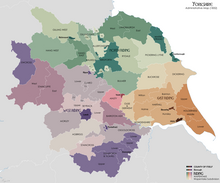
Yorkshire. Langbaurgh East is a dark green colour on the top centre right.
237:
133:
160:"2005 No. 554 MAGISTRATES' COURTS, ENGLAND AND WALES The Local Justice Areas Order 2005"
280:
202:
189:
225:
85:
104:), consisting of the eastern, mostly rural part of the borough of
241:
138:
A History of the County of York North Riding: Volume 2
51:
44:
23:
134:"'The wapentake of Langbaurgh (east): Brotton'"
261:
8:
16:Ancient division of North Yorkshire, England
287:Wapentakes of the North Riding of Yorkshire
268:
254:
34:
20:
96:, England. The name is now in use as a
125:
43:
74:
70:
66:
50:
7:
222:
220:
240:. You can help Knowledge (XXG) by
14:
224:
302:North Yorkshire geography stubs
1:
53: • Preceded by
318:
219:
92:, the eastern division of
297:Places in the Tees Valley
90:North Riding of Yorkshire
75:
71:
67:
63:
33:
28:
140:. 1923. pp. 326–332
102:petty sessional division
236:location article is a
292:Redcar and Cleveland
234:Redcar and Cleveland
106:Redcar and Cleveland
58:Langbaurgh Wapentake
199: /
167:legislation.gov.uk
98:local justice area
249:
248:
79:
78:
309:
270:
263:
256:
228:
221:
214:
213:
211:
210:
209:
204:
203:54.581°N 0.977°W
200:
197:
196:
195:
192:
179:
178:
176:
174:
164:
156:
150:
149:
147:
145:
130:
54:
38:
21:
317:
316:
312:
311:
310:
308:
307:
306:
277:
276:
275:
274:
217:
207:
205:
201:
198:
193:
190:
188:
186:
185:
183:
182:
172:
170:
162:
158:
157:
153:
143:
141:
132:
131:
127:
122:
82:Langbaurgh East
52:
39:
24:Langbaurgh East
17:
12:
11:
5:
315:
313:
305:
304:
299:
294:
289:
279:
278:
273:
272:
265:
258:
250:
247:
246:
229:
208:54.581; -0.977
181:
180:
151:
124:
123:
121:
118:
77:
76:
73:
72:
69:
68:
65:
64:
61:
60:
55:
49:
48:
46:
42:
41:
31:
30:
26:
25:
15:
13:
10:
9:
6:
4:
3:
2:
314:
303:
300:
298:
295:
293:
290:
288:
285:
284:
282:
271:
266:
264:
259:
257:
252:
251:
245:
243:
239:
235:
230:
227:
223:
218:
215:
212:
168:
161:
155:
152:
139:
135:
129:
126:
119:
117:
114:
109:
107:
103:
99:
95:
91:
87:
83:
62:
59:
56:
47:
37:
32:
27:
22:
19:
242:expanding it
231:
216:
184:
171:. Retrieved
166:
154:
142:. Retrieved
137:
128:
110:
100:(formerly a
81:
80:
18:
206: /
113:Scarborough
281:Categories
191:54°34′52″N
120:References
94:Langbaurgh
194:0°58′37″W
86:wapentake
29:Wapentake
144:30 April
173:10 July
88:of the
45:History
169:. 2005
84:was a
232:This
163:(PDF)
238:stub
175:2021
146:2012
108:.
283::
165:.
136:.
269:e
262:t
255:v
244:.
177:.
148:.
Text is available under the Creative Commons Attribution-ShareAlike License. Additional terms may apply.