53:
407:
86:
36:
93:
60:
320:
with a volume of 12,000,000 to 15,000,000 cubic metres (16,000,000 to 20,000,000 cubic yards) — the largest known landslide in Norway in historic time — traveled at high speed from a height of 400 metres (1,312 ft) on the side of the mountain
Tjellafjellet into the Langfjorden about 1 kilometre
329:. The slide generated three megatsunamis in the Langfjorden and the Eresfjorden with heights of 40 to 50 metres (131 to 164 ft). The waves flooded the shore for 200 metres (660 ft) inland in some areas, destroying farms and other inhabited areas. Damaging waves struck as far away as
448:
337:, 40 kilometres (25 mi) from the slide. The waves killed 32 people and destroyed 168 buildings, 196 boats, large amounts of forest, and roads and boat landings.
52:
136:
482:
477:
441:
333:, 25 kilometres (16 mi) from the landslide — where they washed inland 20 metres (66 ft) above normal flood levels — and
434:
85:
20:
346:
302:
298:
467:
366:
194:
406:
294:
283:
275:
267:
180:
414:
279:
251:
121:
326:
322:
306:
201:
472:
418:
208:
390:
Hoel, Christer, "The Tjelle Rock
Avalanche in 1756," fjords.com Retrieved 22 June 2020
35:
461:
259:
168:
389:
334:
290:
187:
151:
138:
317:
309:
is a proposed undersea tunnel that would replace the ferry. The village of
19:
This article is about fjord arm of the
Romsdalsfjord. For other uses, see
330:
297:
at the west end are oriented to the south. The fjord is crossed by the
181:
195:
310:
263:
255:
214:
370:
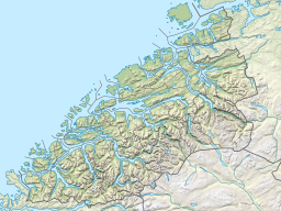
258:. The 35-kilometre (22 mi) long fjord is an arm of the large
247:
173:
262:
which begins between the most easterly point on the island of
278:. The fjord then continues to the east to the village of
422:
232:
224:
220:
207:
193:
179:
167:
128:
117:
28:
129:
313:in Rauma lies on the south shore of the fjord.
442:
316:Just before 8:00 p.m. on 22 February 1756, a
8:
449:
435:
25:
358:
7:
403:
401:
92:
59:
14:
405:
91:
84:
58:
51:
34:
16:Fjord in Møre og Romsdal, Norway
483:Møre og Romsdal geography stubs
231:
223:
1:
116:
421:. You can help Knowledge by
75:Show map of Møre og Romsdal
499:
400:
236:3 kilometres (1.9 mi)
228:35 kilometres (22 mi)
18:
478:Fjords of Møre og Romsdal
45:
33:
347:List of Norwegian fjords
325:and between Tjelle and
417:location article is a
321:(0.6 mi) west of
289:The fjord's two arms,
299:Åfarnes–Sølsnes Ferry
72:Location of the fjord
105:Langfjorden (Norway)
148: /
284:Molde Municipality
276:Rauma Municipality
268:Molde Municipality
152:62.6411°N 7.4159°E
108:Show map of Norway
430:
429:
240:
239:
40:View of the fjord
490:
451:
444:
437:
409:
402:
392:
387:
381:
380:
378:
377:
369:(in Norwegian).
363:
307:Langfjord Tunnel
293:at east end and
197:
196:Primary outflows
183:
163:
162:
160:
159:
158:
153:
149:
146:
145:
144:
141:
131:
109:
95:
94:
88:
76:
62:
61:
55:
38:
26:
498:
497:
493:
492:
491:
489:
488:
487:
458:
457:
456:
455:
415:Møre og Romsdal
398:
396:
395:
388:
384:
375:
373:
365:
364:
360:
355:
343:
252:Møre og Romsdal
211: countries
202:Romsdalsfjorden
182:Primary inflows
157:62.6411; 7.4159
156:
154:
150:
147:
142:
139:
137:
135:
134:
122:Møre og Romsdal
113:
112:
111:
110:
107:
106:
103:
102:
101:
100:
96:
79:
78:
77:
74:
73:
70:
69:
68:
67:
63:
41:
24:
17:
12:
11:
5:
496:
494:
486:
485:
480:
475:
470:
460:
459:
454:
453:
446:
439:
431:
428:
427:
410:
394:
393:
382:
357:
356:
354:
351:
350:
349:
342:
339:
303:County Road 64
238:
237:
234:
230:
229:
226:
222:
221:
218:
217:
212:
205:
204:
199:
191:
190:
185:
177:
176:
171:
165:
164:
132:
126:
125:
124:county, Norway
119:
115:
114:
104:
98:
97:
90:
89:
83:
82:
81:
80:
71:
65:
64:
57:
56:
50:
49:
48:
47:
46:
43:
42:
39:
31:
30:
15:
13:
10:
9:
6:
4:
3:
2:
495:
484:
481:
479:
476:
474:
471:
469:
468:Rauma, Norway
466:
465:
463:
452:
447:
445:
440:
438:
433:
432:
426:
424:
420:
416:
411:
408:
404:
399:
391:
386:
383:
372:
368:
367:"Langfjorden"
362:
359:
352:
348:
345:
344:
340:
338:
336:
332:
328:
324:
319:
314:
312:
308:
304:
301:, as part of
300:
296:
295:Rødvenfjorden
292:
287:
285:
281:
277:
273:
269:
265:
261:
260:Romsdalsfjord
257:
253:
249:
245:
235:
227:
219:
216:
213:
210:
206:
203:
200:
198:
192:
189:
186:
184:
178:
175:
172:
170:
166:
161:
133:
127:
123:
120:
87:
54:
44:
37:
32:
27:
22:
423:expanding it
412:
397:
385:
374:. Retrieved
361:
315:
288:
271:
243:
241:
335:Gjermundnes
291:Eresfjorden
244:Langfjorden
225:Max. length
188:Eresfjorden
155: /
130:Coordinates
99:Langfjorden
66:Langfjorden
29:Langfjorden
21:Langfjorden
462:Categories
376:2010-10-30
353:References
233:Max. width
140:62°38′28″N
318:landslide
272:Okseneset
143:7°24′57″E
341:See also
327:Gramsgrø
254:county,
118:Location
280:Eidsvåg
323:Tjelle
311:Mittet
305:. The
264:Sekken
256:Norway
215:Norway
473:Molde
413:This
371:yr.no
248:fjord
246:is a
209:Basin
174:Fjord
419:stub
331:Veøy
270:and
242:The
169:Type
282:in
274:in
266:in
250:in
464::
286:.
450:e
443:t
436:v
425:.
379:.
23:.
Text is available under the Creative Commons Attribution-ShareAlike License. Additional terms may apply.