435:
62:
87:
273:
48:
94:
69:
252:
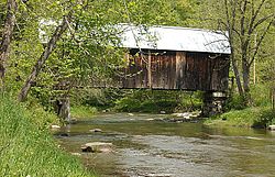
of stone and concrete, and is covered by a metal roof. Its side walls are made of vertical board siding and have no openings. The portal ends and the interiors of the portals are also finished in vertical board siding. Although the trusses are set to form a rectangle, the portals are slightly
838:
863:
843:
815:
284:
294:
228:. Built in 1902, it is one of the last documented covered bridges to be built in Vermont during the historic period of bridge construction, and is one of five covered bridges in the town. It was listed on the
391:
858:
127:
873:
86:
699:
581:
443:
853:
496:
61:
819:
384:
659:
764:
878:
536:
377:
240:
The Larkin
Covered Bridge stands a short way north of the village center of North Tunbridge, on Larkin Road a short way east of its junction with
571:
516:
476:
400:
322:
229:
34:
434:
649:
561:
541:
868:
848:
248:
truss structure, 68 feet (21 m) long and 16 feet (4.9 m) wide, with a 13-foot (4.0 m) roadway (one lane). It rests on
546:
531:
491:
769:
609:
551:
289:
786:
424:
758:
256:
The bridge was built in 1902, and is one of only two documented early 20th-century bridges in the state; the other is the
791:
679:
594:
521:
412:
674:
369:
748:
556:
466:
257:
669:
526:
471:
738:
634:
619:
589:
501:
404:
775:
723:
713:
707:
349:
327:
221:
728:
684:
566:
743:
644:
599:
486:
268:, form a remarkably dense concentration of covered bridges across a single waterway in the state.
639:
614:
225:
115:
361:
664:
654:
624:
604:
261:
241:
345:
451:
265:
264:, built in 1904. The bridge is one of five in Tunbridge, which, when combined with one in
780:
461:
272:
733:
217:
196:
47:
832:
689:
629:
506:
481:
511:
456:
142:
129:
718:
249:
245:
93:
68:
816:
National
Register of Historic Places listings in Orange County, Vermont
285:
National
Register of Historic Places listings in Orange County, Vermont
839:
Covered bridges on the
National Register of Historic Places in Vermont
295:
List of bridges on the
National Register of Historic Places in Vermont
864:
Road bridges on the
National Register of Historic Places in Vermont
317:
805:‡ This historic property also has portions in an adjacent state.
253:
skewed, giving the bridge a parallelogram shape on the outside.
373:
844:
National
Register of Historic Places in Orange County, Vermont
800:
698:
580:
442:
411:
202:
189:
181:
166:
158:
121:
110:
220:, carrying Larkin Road across the First Branch
859:Buildings and structures in Tunbridge, Vermont
820:List of National Historic Landmarks in Vermont
385:
8:
874:King post truss bridges in the United States
600:Chandler Music Hall and Bethany Parish House
346:"NRHP nomination for Larkin Covered Bridge"
660:South Tunbridge Methodist Episcopal Church
392:
378:
370:
271:
46:
854:Covered bridges in Orange County, Vermont
35:U.S. National Register of Historic Places
537:South Newbury Village Historic District
306:
572:West Newbury Village Historic District
339:
337:
318:"National Register Information System"
312:
310:
18:
615:Ely Boston & Maine Railroad Depot
567:Wells River Village Historic District
7:
477:Brookfield Village Historic District
401:National Register of Historic Places
323:National Register of Historic Places
230:National Register of Historic Places
562:Tunbridge Village Historic District
542:Strafford Village Historic District
472:Bradford Village Historic District
14:
547:Thetford Center Historic District
532:Randolph Center Historic District
522:Newbury Village Historic District
492:Chelsea Village Historic District
610:Congregational Church of Chelsea
433:
244:. It is a single-span multiple
92:
85:
67:
60:
552:Thetford Hill Historic District
290:List of Vermont covered bridges
879:1902 establishments in Vermont
787:Thetford Center Covered Bridge
497:Depot Square Historic District
425:Justin Smith Morrill Homestead
191:
1:
595:Central Vermont Railway Depot
101:Show map of the United States
792:Union Village Covered Bridge
16:United States historic place
895:
680:West Fairlee Center Church
869:Wooden bridges in Vermont
849:Bridges completed in 1902
810:
759:Lyme–East Thetford Bridge
675:Wells River Graded School
431:
190:NRHP reference
54:
45:
41:
32:
25:
21:
749:Kingsbury Covered Bridge
557:Thetford Hill State Park
467:Bayley Historic District
258:Kingsbury Covered Bridge
182:Architectural style
670:Waits River Schoolhouse
527:Oxbow Historic District
236:Description and history
185:multiple kingpost truss
739:Gifford Covered Bridge
635:Kimball Public Library
620:Fairlee Railroad Depot
590:Brock Hill Schoolhouse
502:Hayward and Kibby Mill
405:Orange County, Vermont
776:Moxley Covered Bridge
770:Morey Memorial Bridge
754:Larkin Covered Bridge
724:Cilley Covered Bridge
714:Braley Covered Bridge
708:Bedell Covered Bridge
350:National Park Service
328:National Park Service
214:Larkin Covered Bridge
162:1 acre (0.40 ha)
143:43.92278°N 72.46556°W
27:Larkin Covered Bridge
729:Flint Covered Bridge
685:Harlie Whitcomb Farm
765:Mill Covered Bridge
744:Howe Covered Bridge
645:Marvin Newton House
344:Hugh Henry (1974).
148:43.92278; -72.46556
139: /
76:Show map of Vermont
640:Newbury Town House
226:Tunbridge, Vermont
116:Tunbridge, Vermont
826:
825:
655:Post Mills Church
625:Fairlee Town Hall
605:Elwin Chase House
242:Vermont Route 110
210:
209:
886:
452:Allis State Park
437:
394:
387:
380:
371:
364:
362:photos from 1974
359:
357:
356:
341:
332:
331:
314:
275:
193:
177:
175:
154:
153:
151:
150:
149:
144:
140:
137:
136:
135:
132:
102:
96:
95:
89:
77:
71:
70:
64:
50:
19:
894:
893:
889:
888:
887:
885:
884:
883:
829:
828:
827:
822:
806:
796:
781:Piermont Bridge
694:
650:Peabody Library
576:
462:Aloha Hive Camp
438:
429:
416:
414:
407:
398:
368:
367:
354:
352:
343:
342:
335:
330:. July 9, 2010.
316:
315:
308:
303:
281:
238:
173:
171:
147:
145:
141:
138:
133:
130:
128:
126:
125:
106:
105:
104:
103:
100:
99:
98:
97:
80:
79:
78:
75:
74:
73:
72:
37:
28:
17:
12:
11:
5:
892:
890:
882:
881:
876:
871:
866:
861:
856:
851:
846:
841:
831:
830:
824:
823:
811:
808:
807:
804:
802:
798:
797:
795:
794:
789:
784:
778:
773:
767:
762:
756:
751:
746:
741:
736:
734:Foundry Bridge
731:
726:
721:
716:
711:
704:
702:
696:
695:
693:
692:
687:
682:
677:
672:
667:
665:Stratton's Inn
662:
657:
652:
647:
642:
637:
632:
627:
622:
617:
612:
607:
602:
597:
592:
586:
584:
578:
577:
575:
574:
569:
564:
559:
554:
549:
544:
539:
534:
529:
524:
519:
514:
509:
504:
499:
494:
489:
484:
479:
474:
469:
464:
459:
454:
448:
446:
440:
439:
432:
430:
428:
427:
421:
419:
409:
408:
399:
397:
396:
389:
382:
374:
366:
365:
333:
305:
304:
302:
299:
298:
297:
292:
287:
280:
277:
237:
234:
218:covered bridge
216:is a historic
208:
207:
204:
200:
199:
194:
187:
186:
183:
179:
178:
168:
164:
163:
160:
156:
155:
123:
119:
118:
112:
108:
107:
91:
90:
84:
83:
82:
81:
66:
65:
59:
58:
57:
56:
55:
52:
51:
43:
42:
39:
38:
33:
30:
29:
26:
23:
22:
15:
13:
10:
9:
6:
4:
3:
2:
891:
880:
877:
875:
872:
870:
867:
865:
862:
860:
857:
855:
852:
850:
847:
845:
842:
840:
837:
836:
834:
821:
817:
814:
809:
803:
799:
793:
790:
788:
785:
782:
779:
777:
774:
771:
768:
766:
763:
760:
757:
755:
752:
750:
747:
745:
742:
740:
737:
735:
732:
730:
727:
725:
722:
720:
717:
715:
712:
709:
706:
705:
703:
701:
697:
691:
690:Wildwood Hall
688:
686:
683:
681:
678:
676:
673:
671:
668:
666:
663:
661:
658:
656:
653:
651:
648:
646:
643:
641:
638:
636:
633:
631:
630:Goshen Church
628:
626:
623:
621:
618:
616:
613:
611:
608:
606:
603:
601:
598:
596:
593:
591:
588:
587:
585:
583:
579:
573:
570:
568:
565:
563:
560:
558:
555:
553:
550:
548:
545:
543:
540:
538:
535:
533:
530:
528:
525:
523:
520:
518:
517:Asa May House
515:
513:
510:
508:
507:Lanakila Camp
505:
503:
500:
498:
495:
493:
490:
488:
485:
483:
482:Camp Billings
480:
478:
475:
473:
470:
468:
465:
463:
460:
458:
455:
453:
450:
449:
447:
445:
441:
436:
426:
423:
422:
420:
418:
410:
406:
402:
395:
390:
388:
383:
381:
376:
375:
372:
363:
351:
347:
340:
338:
334:
329:
325:
324:
319:
313:
311:
307:
300:
296:
293:
291:
288:
286:
283:
282:
278:
276:
274:
269:
267:
263:
259:
254:
251:
247:
243:
235:
233:
231:
227:
223:
219:
215:
206:July 30, 1974
205:
203:Added to NRHP
201:
198:
195:
188:
184:
180:
169:
165:
161:
157:
152:
124:
120:
117:
113:
109:
88:
63:
53:
49:
44:
40:
36:
31:
24:
20:
812:
753:
353:. Retrieved
321:
270:
255:
239:
224:in northern
213:
211:
114:Larkin Rd.,
512:Mari-Castle
222:White River
146: /
122:Coordinates
833:Categories
700:Structures
487:Camp Wyoda
457:Aloha Camp
355:2016-08-28
301:References
260:in nearby
134:72°27′56″W
131:43°55′22″N
813:See also:
801:Footnotes
719:Bridge 22
582:Buildings
444:Districts
250:abutments
232:in 1974.
417:Landmark
415:Historic
413:National
279:See also
262:Randolph
246:kingpost
197:74000327
111:Location
266:Chelsea
172: (
360:with
167:Built
818:and
212:The
174:1902
170:1902
159:Area
403:in
192:No.
835::
348:.
336:^
326:.
320:.
309:^
783:‡
772:‡
761:‡
710:‡
393:e
386:t
379:v
358:.
176:)
Text is available under the Creative Commons Attribution-ShareAlike License. Additional terms may apply.