210:
40:
163:
159:. Extensive mining began in the headwaters of the Lauricocha in 1927. The Raura mine is one of the highest in the world operating up to an elevation of 4,791 m (15,719 ft). The extensive area of mining activity has polluted some of the area's lakes and interrupted the flow of the river.
217:
The total length of the
Lawriqucha River, in straight-line distance from Niñococha Lake to its junction with the Nupe, is about 50 kilometres (31 mi). A U.S. intelligence agency map of the area calls the lower portion of the Lauricocha River the Quebrada Linda ("Beautiful Gorge").
457:
501:
186:
where archaeologists have found evidence of human habitation 10,000 years ago. The river continues flowing north near the villages of
400:
Fehren-Schmitz; L, Llamas, B.; Lindauer, S.; et al (2015), "A Re-Appraisal of Early Andean Human
Remains from Lauricocha in Peru,"
191:
155:. Several other sources of the Amazon have been proposed. From Niñococha the river flows north through the Raura mine to
383:
Enock, Reginald (1905), "The Ruins of 'Huanuco Viejo' or Old
Huanuco, with Notes on an Expedition to the Upper Marañon,"
352:
187:
432:
234:
Diccionario
Quechua - Español - Quechua, Academía Mayor de la Lengua Quechua, Gobierno Regional Cusco, Cusco 2005:
148:
256:
Teofilo Laime
Ajacopa, Diccionario Bilingüe Iskay simipi yuyayk'ancha, La Paz, 2007 (Quechua-Spanish dictionary):
496:
44:
The headwaters of the
Lawriqucha River may be seen in Sections 19 and 22 of this map. Map can be magnified.
304:
171:
506:
144:
209:
206:
to form the Marañón. The elevation at the junction of the rivers is 3,316 metres (10,879 ft).
133:
95:
183:
107:
125:
78:
167:
114:
53:
39:
162:
199:
156:
147:
at an elevation of 4,809 metres (15,778 ft). In 1952 this lake was identified as the
195:
152:
326:
490:
213:
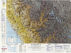
The Nupe (bottom right) joins the
Lauricocha River (center) to form the Marañón.
179:
143:
The
Lawriqucha River originates in a small glacial lake called Niñococha in the
90:
17:
422:
Google Earth Pro, coord: -9.988197, -76.683124 to coord: -10.456322, -76.756823
203:
137:
472:
459:
178:
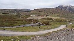
Near
Lauricocha Lake is a stone bridge across the river, dating back to the
388:
208:
161:
129:
68:
246:). Cementerio inkaico en la provincia de Chankay, Lima, Perú.
182:
and still in use for horse and foot travel, and the
120:lake, lagoon, "bluish lake", hispanicized spelling
89:
84:
74:
64:
59:
49:
32:
291:Google Earth Pro, coord: -10.456322, -76,756823
315:Google Earth Pro, coord:-10.313315, -76.700480
413:Google Earth Pro, coord:-9.988197, -76.683124
8:
281:s. Lago. Gran masa de agua en una depresión.
242:s. Hist. (etim. De un dialecto huanuqueño:
387:Vol. 26, No. 2, page 162. Downloaded from
170:crosses the Lauricocha near the hamlet of
227:
437:Latin America Joint Operations Graphic
29:
132:. It belongs to the watershed of the
7:
404:Vol. 10, No. 6, page 2. DOI:10.1371
136:. The river is named after the lake
202:(Runtus) the Lawriqucha joins the
25:
38:
300:"Sebastian Snow," (7 May 2001)
327:"The world's 10 highest mines"
1:
85:Physical characteristics
439:. U.S. Department of Defense
360:The American Alpine Journal
523:
149:source of the Amazon River
37:
502:Rivers of Huánuco Region
268:s. Laguna. Lago pequeño.
151:by an English explorer,
385:The Geographic Journal,
214:
175:
351:Ricker, John (1974).
306:, accessed 6 Oct 2018
212:
165:
145:Raura mountain range
124:) is a river in the
469: /
198:. Near the town of
473:9.9886°S 76.6824°W
353:"Cordillera Raura"
325:Els, Eric (2015).
215:
176:
478:-9.9886; -76.6824
264:qhucha, quchacha.
101:
100:
16:(Redirected from
514:
484:
483:
481:
480:
479:
474:
470:
467:
466:
465:
462:
449:
448:
446:
444:
429:
423:
420:
414:
411:
405:
398:
392:
381:
375:
374:
372:
371:
357:
348:
342:
341:
339:
337:
322:
316:
313:
307:
298:
292:
289:
283:
254:
248:
232:
184:Lauricocha caves
104:Lawriqucha River
42:
33:Lawriqucha River
30:
21:
18:Lauricocha River
522:
521:
517:
516:
515:
513:
512:
511:
487:
486:
477:
475:
471:
468:
463:
460:
458:
456:
455:
453:
452:
442:
440:
431:
430:
426:
421:
417:
412:
408:
399:
395:
382:
378:
369:
367:
355:
350:
349:
345:
335:
333:
324:
323:
319:
314:
310:
299:
295:
290:
286:
255:
251:
233:
229:
224:
157:Lake Lauricocha
140:or Lauricocha.
108:Huánuco Quechua
45:
28:
23:
22:
15:
12:
11:
5:
520:
518:
510:
509:
504:
499:
497:Rivers of Peru
489:
488:
451:
450:
424:
415:
406:
393:
376:
343:
317:
308:
302:The Telegraph,
293:
284:
249:
226:
225:
223:
220:
153:Sebastian Snow
126:Huánuco Region
99:
98:
93:
87:
86:
82:
81:
76:
72:
71:
66:
62:
61:
57:
56:
51:
47:
46:
43:
35:
34:
26:
24:
14:
13:
10:
9:
6:
4:
3:
2:
519:
508:
505:
503:
500:
498:
495:
494:
492:
485:
482:
438:
434:
428:
425:
419:
416:
410:
407:
403:
397:
394:
390:
386:
380:
377:
365:
361:
354:
347:
344:
332:
328:
321:
318:
312:
309:
305:
303:
297:
294:
288:
285:
282:
278:
274:
273:
269:
265:
261:
260:
253:
250:
247:
245:
239:
238:
231:
228:
221:
219:
211:
207:
205:
201:
197:
193:
189:
185:
181:
173:
169:
164:
160:
158:
154:
150:
146:
141:
139:
135:
134:Marañón River
131:
127:
123:
119:
116:
112:
109:
105:
97:
96:Marañón River
94:
92:
88:
83:
80:
77:
73:
70:
67:
63:
58:
55:
52:
48:
41:
36:
31:
27:River in Peru
19:
507:Upper Amazon
454:
441:. Retrieved
436:
427:
418:
409:
401:
396:
384:
379:
368:. Retrieved
363:
359:
346:
334:. Retrieved
330:
320:
311:
301:
296:
287:
280:
276:
271:
270:
267:
263:
258:
257:
252:
243:
241:
236:
235:
230:
216:
177:
168:stone bridge
142:
121:
117:
110:
103:
102:
476: /
433:"Pativilca"
180:Inca Empire
491:Categories
464:76°40′57″W
370:2016-05-27
222:References
204:Nupe River
172:Lauricocha
138:Lawriqucha
122:Lauricocha
461:9°59′19″S
402:PLOS ONE,
190:(Kawri),
50:Etymology
443:20 April
336:22 April
166:An Inca
113:bluish,
60:Location
277:qhucha.
244:azulado
115:Quechua
79:Huánuco
65:Country
54:Quechua
331:Mining
200:Rondos
75:Region
389:JSTOR
356:(PDF)
272:qucha
259:qucha
237:Lawri
196:Jivia
192:Jesús
188:Cauri
118:qucha
111:lawri
91:Mouth
445:2024
338:2023
194:and
130:Peru
69:Peru
366:(1)
128:in
493::
435:.
364:19
362:.
358:.
329:.
279:-
275:,
266:-
262:,
240:-
447:.
391:.
373:.
340:.
174:.
106:(
20:)
Text is available under the Creative Commons Attribution-ShareAlike License. Additional terms may apply.