1372:
192:
99:
825:
1093:
92:
40:
176:
894:
202:
231:
217:
300:. Nevertheless, it is in fact an artificial name made up by Walther Flaig at a time when the development of mountaineering in the Alps had been largely completed. Previously, the mountain range had been called either the Klostertal Alps or counted as part of the Lechtal Alps east of the Flexen Pass.
815:
follows the southern edge of the
Lechquellen mountains. Its power is supplied by hydroelectricity from the overflow of the Spullersee, which lies at a height of 700 metres above the Klostertal valley in the southern part of the Lechquellen mountains.
398:, a well-known alpine guide and author from Vorarlberg, had a significant influence on the definition and extent of the Lechquellen Mountains. The name he gave to the mountains and his definition of their extent was included in the
707:
The use of high-altitude roads (tolls) allows the motor vehicle to penetrate the interior of the mountains to a height of almost 2000 meters. But there are also larger areas with marked seclusion.
912:
runs from Zürs to Damüls via the
Madlochjoch, the Ravensburger Hut, the Freiburger Hut, the Göppinger Hut and the Biberacher Hut. The last section from the Faschinajoch to Damüls runs through the
323:
will work out and lay down an internationally recognized classification of the Alps. If they do, then the
Lechquellen Mountains will either be officially recognised or absorbed into other groups.
303:
Artificial names often find it hard to establish themselves in everyday language. By contrast, there are Alpine groups named after placenames that go back centuries or even millennia, such as the
1134:
1033:. As a result, these core zones already present today the image of natural mountainous (virgin) forests with trees of different age classes and a high proportion of dead-wood in the
292:(literally "Lech source mountains") is certainly accurate, for the greater part of the mountain range surrounds the upper reaches of the Lech with its two spring-fed streams, the
315:. It will take decades to determine whether the name of the Lechquellen Mountains has prevailed as naturally as the name of other Alpine groups. It is also unclear whether the
1200:
1092:
399:
142:
376:
749:
The
Lechquellen mountains was made accessible in the second half of the 19th century. The small mountain group includes the upper part of the river
375:
saddle. From there it descends into the Große
Walsertal and along the Lutz to its confluence with the Ill. It then follows the Ill back to Bludenz.
1099:
417:
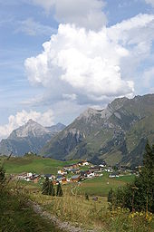
Rauhes Joch (Location of the "Freiburger Hut", 1.918 m (AA), accessible from the east by road, the crossing is also accessible by mountain bikes)
1406:
1142:
1193:
796:. Narrow toll roads lead to the valleys, and a shuttle bus from Lech leads to the Lechquellen in summer. On the other hand, it is ideal for
1396:
808:
which follows the entire "horseshoe" of the peaks, but requires some alpine experience - at least until the middle of the summer.
1411:
1401:
1186:
91:
714:- a name which is found in many Tyrolean family names. Historically, alpine farming dominates and is known today under the term
1416:
1010:
1391:
528:
195:
926:, a cross-border long-distance path with five sections through the whole Alps, also runs through the Lechquellen Mountains.
351:
and along the Lech to its confluence with the
Krumbach. The Krumbach forms the boundary of the range in the north up to the
1371:
135:
191:
951:
Stage R54 runs from
Buchboden to St. Gerold. The second part of this stage is located in the Bregenz Forest Mountains.
1017:
also covers parts of the
Lechquellen Mountains. Particularly interesting are the core zones, which, according to
1246:
913:
479:
389:
311:. Others are named after valleys that have been referred to by the same name from time immemorial, such as the
1021:, must be part of every biosphere reserve. In the Lechquellen mountains there are two larger core zones, the
1331:
1210:
1034:
824:
519:
257:
180:
61:
1316:
352:
537:
665:
570:
882:
647:
1321:
1271:
762:
758:
856:
840:
602:
410:
In addition to the named passes, there are no other passes or crossings that are accessible by car.
1326:
1256:
864:
715:
638:
463:
451:
395:
692:
683:
674:
372:
293:
1236:
1178:
848:
656:
588:
297:
210:
611:
1296:
966:
789:
726:
348:
987:
957:
769:. Because of the great popularity another hut named Freiburger hut was opened in 1912 on the
629:
1336:
1311:
1276:
1241:
1231:
1014:
872:
774:
754:
444:
277:
1301:
1266:
833:
812:
364:
243:
1346:
1221:
1042:
1029:. The mountain forests in these core zones have not been used for a number of years in
938:
785:
485:
385:
367:
and its confluence with the
Argenbach. Then it goes up the Argenbach until just before
320:
312:
1162:
1385:
1341:
1306:
1251:
1226:
941:. Making its way between the Hochtannberg Pass and Schröcken past the Kälbelesee and
805:
360:
39:
1361:
1356:
1291:
1261:
948:
Stage R53 runs from Schröcken to
Buchboden over the Schadona Pass (Biberacher Hut).
937:
Stage R52 runs from the Mindelheimer Hut to Schröcken. This stage is mainly in the
801:
750:
718:, a 3-phase lifestyle that highly influenced culture, traditions and architecture.
579:
497:
491:
381:
273:
261:
184:
175:
45:
942:
356:
17:
1351:
1074:
962:
893:
766:
340:
201:
1135:"Land Vorarlberg - Ausstellung "Das Lechquellengebirge und seine Erschließung""
922:
781:
620:
503:
429:
336:
269:
124:
157:
144:
1281:
475:
The Lechquellen Mountains border on the following other groups in the Alps:
331:
The southern boundary of Lechquellen Mountains runs from the alpine town of
224:
970:
734:
1030:
304:
997:
793:
730:
598:
Other well known peaks in the Lechquellen, in order of height are the:
459:
440:
425:
368:
344:
332:
308:
265:
206:
128:
230:
216:
1018:
797:
780:
The Lechquellen mountains are little developed, apart from the large
738:
722:
711:
68:
881:
These huts, with the exception of the Frassen Hut, are part of the
892:
823:
229:
215:
200:
190:
174:
316:
1182:
276:
with its headstreams in a horseshoe shape as well as the Upper
111:
Location of the Lechquellen (in yellow) within the Eastern Alps
1102:
360° panorama from the summit of the Zitterklapfen (2,403 m)
901:
North Alpine long-distance path 01, the Limestone Alps Way (
380:
The Flexen Pass connects the Lechquellen Mountains with the
933:) has 3 stages running through the Lechquellen as follows:
515:
The 10 highest peaks in the Lechquellen Mountains are the:
355:. From there, it runs along the Seebach via the village of
371:
and continues along the Faschinabach in the west to the
234:
The Gipslöcher nature reserve. Rear left: the Biberkopf
1056:
Bödener Magerwiesen, established 1991, size 16,5 ha
134:
120:
79:
67:
57:
52:
32:
1053:Gipslöcher Oberlech, established 1988, size 21 ha
1167:at www.via-alpina.org. Retrieved on 17 Oct 2014.
400:Alpine Club classification of the Eastern Alps
384:. The Hochtannberg Pass forms the link to the
1194:
388:. The Faschinajoch is the connexion with the
98:
8:
1085:Gadental, established 1995, size 1.543,77 ha
753:with it spring streams as well as the upper
710:The valleys were populated by the so-called
272:and includes the upper reaches of the river
343:. From there, it continues in the east via
1201:
1187:
1179:
1120:Fink, Humbert and Pflanzer, Hella (1993).
757:. The first hut was opened in 1894 by the
745:Development of local public infrastructure
29:
1050:Gadental, established 1987, size 1.336 ha
413:Other relevant touristic crossings are:
1069:Körbersee, established 1958, size 451 ha
1113:
905:), crosses the Lechquellen as follows:
552:Mittlere Wildgrubenspitze, centre top,
876:1,948 m above sea level (AA)
868:2,245 m above sea level (AA)
860:1,931 m above sea level (AA)
852:1,725 m above sea level (AA)
844:1,842 m above sea level (AA)
777:near the Spullersee in the same year.
697:1,979 m above sea level (AA)
688:2,211 m above sea level (AA)
679:2,257 m above sea level (AA)
670:2,271 m above sea level (AA)
661:2,284 m above sea level (AA)
652:2,397 m above sea level (AA)
643:2,403 m above sea level (AA)
634:2,416 m above sea level (AA)
625:2,542 m above sea level (AA)
616:2,600 m above sea level (AA)
607:2,649 m above sea level (AA)
593:2,665 m above sea level (AA)
584:2,672 m above sea level (AA)
575:2,679 m above sea level (AA)
566:2,685 m above sea level (AA)
560:2,688 m above sea level (AA)
554:2,695 m above sea level (AA)
548:2,696 m above sea level (AA)
542:2,702 m above sea level (AA)
533:2,704 m above sea level (AA)
524:2,753 m above sea level (AA)
456:2,245 m above sea level (AA)
437:2,011 m above sea level (AA)
422:1,827 m above sea level (AA)
74:2,753 m above sea level (AA)
546:Mittlere Wildgrubenspitze, east top,
256:is a small mountain group within the
44:Lechquellen Mountains: view into the
7:
25:
929:The Red Trail of the Via Alpina (
1370:
1091:
1059:Faludriga Nova, established 2003
996:Francesco Tarmann Klettersteig (
97:
90:
38:
945:it also enters the Lechquellen.
264:. It lies entirely within the
205:Zürsersee; in the background:
1:
1407:Mountain ranges of Vorarlberg
729:and the smaller villages of
1397:Mountain ranges of the Alps
1141:(in German). Archived from
961:runs 125 km from lake
450:Gamsboden (Location of the
1433:
897:Start of the Lechweg trail
761:section of the German and
721:Today tourism, especially
1368:
1217:
800:and there is a system of
84:
37:
27:Mountain group in Austria
1041:There are the following
914:Bregenz Forest Mountains
811:The western ramp of the
480:Bregenz Forest Mountains
390:Bregenz Forest Mountains
359:and continues along the
1412:Mountains of Vorarlberg
1402:Northern Limestone Alps
1211:Northern Limestone Alps
1209:Mountain ranges of the
1035:Northern Limestone Alps
931:Rote Weg der Via Alpina
520:Untere Wildgrubenspitze
258:Northern Limestone Alps
181:Untere Wildgrubenspitze
62:Untere Wildgrubenspitze
1417:Natura 2000 in Austria
1317:Upper Austrian Prealps
1122:Impressions of Austria
1064:Plant protection area:
982:Fixed rope route (DE:
898:
829:
558:Rote Wand, Ostgipfel,
353:Hochtann Mountain Pass
247:
235:
227:
223:nature reserve on the
213:
198:
188:
1392:Lechquellen Mountains
1082:Bergwälder Klostertal
993:Panorama Klettersteig
896:
827:
240:Lechquellen Mountains
233:
219:
204:
194:
178:
105:Lechquellen Mountains
33:Lechquellen Mountains
1322:Rax-Schneeberg Group
763:Austrian Alpine Club
406:Passes and crossings
307:or the neighbouring
278:Großwalsertal valley
1327:Salzburg Slate Alps
889:Long-distance paths
716:alpine transhumance
471:Neighbouring ranges
154: /
1237:Berchtesgaden Alps
899:
836:in the mountains:
830:
538:Großer Grätlisgrat
506:(to the southwest)
488:(to the northeast)
290:Lechquellengebirge
284:Origin of the name
249:Lechquellengebirge
236:
228:
214:
199:
189:
158:47.18611°N 9.985°E
53:Highest point
18:Lechquellengebirge
1379:
1378:
1139:www.vorarlberg.at
1124:, Pinguin-Verlag.
1005:Nature protection
977:Fixed rope routes
773:, as well as the
571:Spuller Schafberg
254:Lechquellen range
173:
172:
136:Range coordinates
16:(Redirected from
1424:
1374:
1242:Brandenberg Alps
1232:Bavarian Prealps
1203:
1196:
1189:
1180:
1168:
1160:
1154:
1153:
1151:
1150:
1131:
1125:
1118:
1095:
883:Lechquellenrunde
877:
873:Ravensburger Hut
869:
861:
853:
845:
834:Alpine Club huts
820:Alpine Club huts
775:Ravensburger hut
698:
689:
680:
671:
662:
653:
648:Hochkünzelspitze
644:
635:
626:
617:
608:
594:
585:
576:
567:
561:
555:
549:
543:
534:
525:
458:, crossing from
457:
445:Ravensburger Hut
438:
424:, crossing from
423:
169:
168:
166:
165:
164:
159:
155:
152:
151:
150:
147:
101:
100:
94:
75:
42:
30:
21:
1432:
1431:
1427:
1426:
1425:
1423:
1422:
1421:
1382:
1381:
1380:
1375:
1366:
1267:Gutenstein Alps
1213:
1207:
1177:
1172:
1171:
1161:
1157:
1148:
1146:
1133:
1132:
1128:
1119:
1115:
1110:
1105:
1104:
1103:
1101:
1096:
1043:nature reserves
1007:
979:
910:Section 17
891:
875:
867:
859:
851:
843:
832:There are five
822:
813:Arlberg railway
804:connected by a
747:
705:
696:
687:
678:
669:
660:
651:
642:
633:
624:
615:
606:
592:
583:
574:
573:, Hauptgipfel,
565:
559:
553:
547:
541:
532:
523:
513:
473:
464:Große Walsertal
455:
436:
435:Stierlochjoch (
421:
408:
329:
286:
163:47.18611; 9.985
162:
160:
156:
153:
148:
145:
143:
141:
140:
116:
115:
114:
113:
112:
109:
108:
107:
106:
102:
73:
48:
28:
23:
22:
15:
12:
11:
5:
1430:
1428:
1420:
1419:
1414:
1409:
1404:
1399:
1394:
1384:
1383:
1377:
1376:
1369:
1367:
1365:
1364:
1359:
1354:
1349:
1344:
1339:
1334:
1329:
1324:
1319:
1314:
1309:
1304:
1299:
1294:
1289:
1284:
1279:
1274:
1269:
1264:
1259:
1254:
1249:
1247:Bregenz Forest
1244:
1239:
1234:
1229:
1224:
1218:
1215:
1214:
1208:
1206:
1205:
1198:
1191:
1183:
1176:
1175:External links
1173:
1170:
1169:
1155:
1126:
1112:
1111:
1109:
1106:
1098:
1097:
1090:
1089:
1088:
1087:
1086:
1083:
1071:
1070:
1061:
1060:
1057:
1054:
1051:
1027:Faludriga Nova
1006:
1003:
1002:
1001:
994:
991:
978:
975:
953:
952:
949:
946:
918:
917:
890:
887:
879:
878:
870:
862:
857:Freiburger Hut
854:
846:
841:Biberacher Hut
828:Freiburger Hut
821:
818:
746:
743:
741:is important.
704:
701:
700:
699:
690:
681:
672:
663:
654:
645:
636:
627:
618:
609:
603:Braunarlspitze
596:
595:
586:
577:
568:
562:
556:
550:
544:
535:
526:
512:
509:
508:
507:
501:
500:(to the south)
495:
489:
483:
482:(to the north)
472:
469:
468:
467:
448:
439:, Access from
433:
418:
407:
404:
328:
325:
321:European Union
285:
282:
187:and Rhonspitze
171:
170:
138:
132:
131:
122:
118:
117:
110:
104:
103:
96:
95:
89:
88:
87:
86:
85:
82:
81:
77:
76:
71:
65:
64:
59:
55:
54:
50:
49:
43:
35:
34:
26:
24:
14:
13:
10:
9:
6:
4:
3:
2:
1429:
1418:
1415:
1413:
1410:
1408:
1405:
1403:
1400:
1398:
1395:
1393:
1390:
1389:
1387:
1373:
1363:
1360:
1358:
1355:
1353:
1350:
1348:
1345:
1343:
1342:Totes Gebirge
1340:
1338:
1335:
1333:
1332:Salzkammergut
1330:
1328:
1325:
1323:
1320:
1318:
1315:
1313:
1312:Mürzsteg Alps
1310:
1308:
1307:Mieming Range
1305:
1303:
1300:
1298:
1295:
1293:
1290:
1288:
1285:
1283:
1280:
1278:
1275:
1273:
1270:
1268:
1265:
1263:
1260:
1258:
1255:
1253:
1252:Chiemgau Alps
1250:
1248:
1245:
1243:
1240:
1238:
1235:
1233:
1230:
1228:
1227:Ammergau Alps
1225:
1223:
1220:
1219:
1216:
1212:
1204:
1199:
1197:
1192:
1190:
1185:
1184:
1181:
1174:
1166:
1165:
1164:The Red Trail
1159:
1156:
1145:on 2017-04-27
1144:
1140:
1136:
1130:
1127:
1123:
1117:
1114:
1107:
1100:
1094:
1084:
1081:
1080:
1079:
1078:
1076:
1068:
1067:
1066:
1065:
1058:
1055:
1052:
1049:
1048:
1047:
1046:
1044:
1038:
1036:
1032:
1028:
1025:and the area
1024:
1020:
1016:
1015:Großwalsertal
1012:
1004:
999:
995:
992:
990:(2416 m)
989:
985:
984:Klettersteig)
981:
980:
976:
974:
972:
968:
964:
960:
959:
950:
947:
944:
940:
936:
935:
934:
932:
927:
925:
924:
915:
911:
908:
907:
906:
904:
895:
888:
886:
884:
874:
871:
866:
865:Göppinger Hut
863:
858:
855:
850:
847:
842:
839:
838:
837:
835:
826:
819:
817:
814:
809:
807:
806:mountain path
803:
802:mountain huts
799:
795:
791:
787:
783:
778:
776:
772:
768:
764:
760:
756:
755:Großwalsertal
752:
744:
742:
740:
737:, as well as
736:
733:, Stuben and
732:
728:
724:
719:
717:
713:
708:
702:
694:
691:
685:
682:
676:
673:
667:
664:
658:
655:
649:
646:
640:
639:Zitterklapfen
637:
631:
628:
622:
619:
613:
610:
604:
601:
600:
599:
590:
587:
581:
578:
572:
569:
563:
557:
551:
545:
539:
536:
530:
527:
521:
518:
517:
516:
510:
505:
502:
499:
496:
494:(to the east)
493:
490:
487:
484:
481:
478:
477:
476:
470:
465:
461:
453:
452:Göppinger Hut
449:
446:
442:
434:
431:
427:
419:
416:
415:
414:
411:
405:
403:
401:
397:
396:Walther Flaig
393:
391:
387:
383:
378:
377:
374:
370:
366:
363:stream up to
362:
361:Bregenzer Ach
358:
354:
350:
346:
342:
338:
334:
326:
324:
322:
318:
314:
310:
306:
301:
299:
295:
291:
283:
281:
279:
275:
271:
267:
263:
259:
255:
251:
250:
245:
241:
232:
226:
222:
218:
212:
208:
203:
197:
193:
186:
182:
177:
167:
139:
137:
133:
130:
126:
123:
119:
93:
83:
78:
72:
70:
66:
63:
60:
56:
51:
47:
41:
36:
31:
19:
1362:Ybbstal Alps
1357:Vienna Woods
1347:Türnitz Alps
1292:Lechtal Alps
1286:
1262:Ennstal Alps
1163:
1158:
1147:. Retrieved
1143:the original
1138:
1129:
1121:
1116:
1073:
1072:
1063:
1062:
1040:
1039:
1026:
1022:
1008:
983:
956:
954:
930:
928:
921:
919:
909:
903:Kalkalpenweg
902:
900:
880:
831:
810:
779:
770:
748:
720:
709:
706:
693:Hoher Fraßen
684:Gamsfreiheit
675:Warther Horn
597:
580:Roggalspitze
514:
498:Verwall Alps
492:Lechtal Alps
474:
420:Spullersee (
412:
409:
394:
382:Lechtal Alps
379:
373:Faschinajoch
330:
319:or even the
302:
294:Formarinbach
289:
287:
262:Eastern Alps
253:
248:
239:
237:
220:
185:Roggalspitze
179:View of the
1352:Wetterstein
1287:Lechquellen
1222:Allgäu Alps
1075:Natura-2000
973:(Germany).
963:Formarinsee
939:Allgäu Alps
849:Frassen Hut
782:ski resorts
771:Rauhen Joch
767:Formarinsee
725:tourism in
657:Roggelskopf
589:Wasenspitze
486:Allgäu Alps
386:Allgäu Alps
341:Flexen Pass
313:Ötztal Alps
298:Spullerbach
161: /
46:Lech valley
1386:Categories
1272:Hochschwab
1149:2017-04-26
1108:References
923:Via Alpina
666:Feuerstein
621:Mohnenfluh
430:Klostertal
337:Klostertal
335:along the
270:Vorarlberg
221:Gipslöcher
211:Roggspitze
146:47°11′10″N
125:Vorarlberg
1282:Karwendel
1257:Dachstein
1011:biosphere
943:Körbersee
612:Hochlicht
529:Rote Wand
357:Schröcken
288:The name
268:state of
225:Biberkopf
196:Rote Wand
149:9°59′06″E
80:Geography
69:Elevation
1031:forestry
1023:Gadental
1013:reserve
967:Lechfall
786:railways
765:at lake
759:Freiburg
305:Raetikon
296:and the
266:Austrian
1297:Leogang
1077:-areas:
998:Ludesch
988:Karhorn
986:on the
965:to the
958:Lechweg
712:Walsers
703:Tourism
630:Karhorn
564:Nadel,
511:Summits
504:Rätikon
460:Lechtal
443:to the
441:Lechtal
426:Lechtal
402:(AVE).
369:Damuels
339:to the
333:Bludenz
309:Verwall
260:of the
207:Valluga
129:Austria
1337:Tennen
1277:Kaiser
1019:UNESCO
971:Füssen
798:hikers
739:hiking
735:Damüls
327:Extent
244:German
1302:Lofer
252:) or
121:State
1009:The
955:The
920:The
794:Zürs
792:and
790:Lech
784:and
751:Lech
731:Zürs
727:Lech
349:Lech
347:and
345:Zürs
317:UIAA
274:Lech
238:The
209:and
58:Peak
969:in
788:at
723:ski
462:to
428:to
1388::
1137:.
1037:.
885:.
695:,
686:,
677:,
668:,
659:,
650:,
641:,
632:,
623:,
614:,
605:,
591:,
582:,
540:,
531:,
522:,
454:,
392:.
365:Au
280:.
246::
183:,
127:,
1202:e
1195:t
1188:v
1152:.
1045::
1000:)
916:.
466:)
447:)
432:)
242:(
20:)
Text is available under the Creative Commons Attribution-ShareAlike License. Additional terms may apply.