363:
375:
57:
90:
812:
387:
351:
97:
64:
338:
The village was first mentioned between 1395 and 1396 as
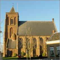
Lederbroec, and means "canal through swampy land". Leerbroek started as a cultivation project in the 12th century. The Dutch Reformed Church dated from the 16th century, but burnt down in 1935. It was rebuilt in 1936. In 1840, it was home to
623:
362:
374:
616:
877:
872:
796:
40:
609:
887:
853:
470:
181:
56:
273:
285:
125:
89:
633:
557:
495:
846:
350:
755:
265:
169:
330:. When Zederik merged into the new municipality Vijfheerenlanden in 2019, it became a part of the province of Utrecht.
760:
724:
386:
882:
839:
157:
474:
765:
601:
770:
547:
244:
39:
734:
254:
692:
819:
304:
174:
553:
823:
637:
308:
186:
687:
415:
811:
468:
Ad van der Meer and Onno
Boonstra, "Repertorium van Nederlandse gemeenten", KNAW, 2006.
866:
729:
327:
775:
697:
520:
300:
162:
318:
Leerbroek was a separate municipality between 1817, when it was separated from
785:
739:
677:
140:
127:
780:
682:
312:
235:
719:
704:
319:
580:
714:
656:
323:
30:
661:
651:
261:
240:
443:
605:
827:
496:"Fusiegemeente Vijfheerenlanden in provincie Utrecht"
311:, and lies about 9 km (6 mi) northeast of
748:
670:
644:
284:
272:
251:
234:
226:
218:
213:
205:
197:
192:
180:
168:
156:
21:
847:
797:List of cities, towns and villages in Utrecht
617:
8:
546:Ronald Stenvert & Chris Kolman (1996).
854:
840:
624:
610:
602:
18:
471:"KNAW > Publicaties > Detailpagina"
402:
346:
271:
233:
212:
204:
191:
155:
120:
48:
36:
878:Populated places in Utrecht (province)
873:Former municipalities of South Holland
410:
408:
406:
356:Map of the former municipality in 1866
307:. It is a part of the municipality of
283:
250:
225:
217:
196:
179:
167:
7:
808:
806:
416:"Kerncijfers wijken en buurten 2021"
201:3.59 km (1.39 sq mi)
888:Utrecht (province) geography stubs
826:. You can help Knowledge (XXG) by
14:
521:"Leerbroek - (geografische naam)"
96:
63:
810:
385:
373:
361:
349:
322:, and 1986, when it merged with
95:
88:
62:
55:
38:
450:(in Dutch). Het Waterschapshuis
448:Actueel Hoogtebestand Nederland
16:Village in Utrecht, Netherlands
552:(in Dutch). Zwolle: Waanders.
79:Show map of Utrecht (province)
1:
420:Central Bureau of Statistics
76:Location in the Netherlands
904:
805:
209:−0.1 m (−0.3 ft)
794:
444:"Postcodetool for 4245JS"
121:
49:
37:
28:
632:Populated places in the
230:300/km (780/sq mi)
112:Show map of Netherlands
109:Leerbroek (Netherlands)
822:location article is a
253: • Summer (
735:Tienhoven aan de Lek
299:is a village in the
227: • Density
326:in the province of
137: /
44:Church of Leerbroek
392:House in Leerbroek
368:Farms in Leerbroek
219: • Total
198: • Total
141:51.9071°N 5.0497°E
835:
834:
803:
802:
294:
293:
895:
883:Vijfheerenlanden
856:
849:
842:
814:
807:
701:
638:Vijfheerenlanden
626:
619:
612:
603:
597:
596:
594:
592:
577:
571:
570:
568:
566:
543:
537:
536:
534:
532:
517:
511:
510:
508:
506:
492:
486:
485:
483:
482:
473:. Archived from
466:
460:
459:
457:
455:
440:
434:
433:
428:
426:
412:
389:
377:
365:
353:
309:Vijfheerenlanden
258:
187:Vijfheerenlanden
152:
151:
149:
148:
147:
142:
138:
135:
134:
133:
130:
113:
99:
98:
92:
80:
66:
65:
59:
42:
19:
903:
902:
898:
897:
896:
894:
893:
892:
863:
862:
861:
860:
804:
799:
790:
744:
695:
688:Hei- en Boeicop
666:
640:
630:
600:
590:
588:
579:
578:
574:
564:
562:
560:
545:
544:
540:
530:
528:
519:
518:
514:
504:
502:
494:
493:
489:
480:
478:
469:
467:
463:
453:
451:
442:
441:
437:
424:
422:
414:
413:
404:
400:
393:
390:
381:
378:
369:
366:
357:
354:
345:
336:
280:
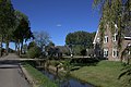
252:
146:51.9071; 5.0497
145:
143:
139:
136:
131:
128:
126:
124:
123:
117:
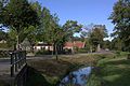
116:
115:
114:
111:
110:
107:
106:
105:
104:
100:
83:
82:
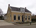
81:
78:
77:
74:
73:
72:
71:
67:
45:
33:
24:
17:
12:
11:
5:
901:
899:
891:
890:
885:
880:
875:
865:
864:
859:
858:
851:
844:
836:
833:
832:
815:
801:
800:
795:
792:
791:
789:
788:
783:
778:
773:
768:
763:
758:
752:
750:
746:
745:
743:
742:
737:
732:
727:
722:
717:
712:
707:
702:
690:
685:
680:
674:
672:
668:
667:
665:
664:
659:
654:
648:
646:
642:
641:
631:
629:
628:
621:
614:
606:
599:
598:
572:
558:
538:
525:Etymologiebank
512:
487:
461:
435:
401:
399:
396:
395:
394:
391:
384:
382:
379:
372:
370:
367:
360:
358:
355:
348:
344:
341:
335:
332:
292:
291:
288:
282:
281:
278:
276:
270:
269:
259:
249:
248:
238:
232:
231:
228:
224:
223:
220:
216:
215:
211:
210:
207:
203:
202:
199:
195:
194:
190:
189:
184:
178:
177:
172:
166:
165:
160:
154:
153:
119:
118:
108:
102:
101:
94:
93:
87:
86:
85:
84:
75:
69:
68:
61:
60:
54:
53:
52:
51:
50:
47:
46:
43:
35:
34:
29:
26:
25:
22:
15:
13:
10:
9:
6:
4:
3:
2:
900:
889:
886:
884:
881:
879:
876:
874:
871:
870:
868:
857:
852:
850:
845:
843:
838:
837:
831:
829:
825:
821:
816:
813:
809:
798:
793:
787:
784:
782:
779:
777:
774:
772:
769:
767:
764:
762:
759:
757:
754:
753:
751:
747:
741:
738:
736:
733:
731:
730:Schoonrewoerd
728:
726:
723:
721:
718:
716:
713:
711:
708:
706:
703:
699:
694:
691:
689:
686:
684:
681:
679:
676:
675:
673:
669:
663:
660:
658:
655:
653:
650:
649:
647:
643:
639:
635:
627:
622:
620:
615:
613:
608:
607:
604:
586:
582:
576:
573:
561:
559:90-400-9757-7
555:
551:
550:
542:
539:
526:
522:
516:
513:
501:
497:
491:
488:
477:on 2007-02-20
476:
472:
465:
462:
449:
445:
439:
436:
432:
421:
417:
411:
409:
407:
403:
397:
388:
383:
376:
371:
364:
359:
352:
347:
342:
340:
333:
331:
329:
328:South Holland
325:
321:
316:
314:
310:
306:
302:
298:
289:
287:
277:
275:
267:
263:
260:
256:
246:
242:
239:
237:
229:
221:
208:
200:
188:
185:
183:
176:
173:
171:
164:
161:
159:
150:
122:Coordinates:
91:
58:
41:
32:
27:
20:
828:expanding it
817:
776:Kortenhoeven
709:
693:Hoef en Haag
634:municipality
589:. Retrieved
585:Plaatsengids
584:
575:
563:. Retrieved
548:
541:
529:. Retrieved
524:
515:
503:. Retrieved
499:
490:
479:. Retrieved
475:the original
464:
452:. Retrieved
447:
438:
430:
423:. Retrieved
419:
339:214 people.
337:
317:
303:province of
296:
295:
286:Dialing code
182:Municipality
696: [
581:"Leerbroek"
431:two entries
274:Postal code
163:Netherlands
144: /
867:Categories
786:Middelkoop
756:Achterdijk
740:Zijderveld
678:Everdingen
587:(in Dutch)
527:(in Dutch)
505:12 January
481:2009-12-03
398:References
380:More farms
214:Population
129:51°54′26″N
781:Lakerveld
761:Achthoven
725:Nieuwland
710:Leerbroek
683:Hagestein
549:Leerbroek
313:Gorinchem
297:Leerbroek
236:Time zone
206:Elevation
132:5°02′59″E
103:Leerbroek
70:Leerbroek
23:Leerbroek
720:Meerkerk
705:Kedichem
671:Villages
591:26 March
565:26 March
531:26 March
454:26 March
425:26 March
320:Meerkerk
170:Province
820:Utrecht
749:Hamlets
715:Lexmond
657:Leerdam
343:Gallery
334:History
324:Zederik
305:Utrecht
175:Utrecht
158:Country
31:Village
662:Vianen
652:Ameide
556:
818:This
766:Broek
700:]
645:Towns
500:AD.nl
301:Dutch
262:UTC+2
241:UTC+1
222:1,085
824:stub
771:Geer
593:2022
567:2022
554:ISBN
533:2022
507:2019
456:2022
427:2022
290:0345
279:4245
266:CEST
193:Area
636:of
255:DST
245:CET
869::
698:nl
583:.
523:.
498:.
446:.
429:.
418:.
405:^
315:.
855:e
848:t
841:v
830:.
625:e
618:t
611:v
595:.
569:.
535:.
509:.
484:.
458:.
268:)
264:(
257:)
247:)
243:(
Text is available under the Creative Commons Attribution-ShareAlike License. Additional terms may apply.