44:
77:
27:
84:
51:
387:[The mystery at Herlaugshaugen continues - Closer examinations of Herlaugshaugen at Leka has not given more answers about what is hiding in the mound. They have nevertheless identified some new discoveries] (in Norwegian). NRK.
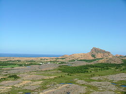
243:. The 57-square-kilometre (22 sq mi) island makes up about half of the area of the municipality of Leka. The island is surrounded by dozens of smaller islands. The smaller island of
385:"Mysteriet på Herlaugshaugen fortsetter - Nærmere undersøkelser av Herlaugshaugen på Leka har ikke gitt flere svar på hva som skjuler seg i haugen. De har likevel kartlagt noen nye funn"
251:
lies about 4 kilometres (2.5 mi) east of Leka. There is a ferry connection between Leka and Austra, and Austra is connected to the mainland by a bridge.
43:
133:
424:
402:
76:
330:
429:
407:(in Norwegian) (15 ed.). Kristiania, Norge: W. C. Fabritius & sønners bogtrikkeri. p. 369.
359:
259:
255:
298:
384:
364:
244:
247:
lies south of Leka, and it is connected to Leka by a short bridge. The larger island of
418:
283:
295:
232:
216:
236:
206:
117:
262:
of Leka municipality and it is located on the northeast part of the island. The
287:
267:
263:
26:
291:
148:
135:
398:
310:
279:
248:
240:
228:
121:
317:. The meaning of the name is unknown, but it may come from the word
282:
has been inhabited for at least 10,000 years, as evidenced by
354:
212:
202:
188:
180:
172:
164:
127:
113:
108:
290:at the southwest tip of the island. Dated to the
301:is one of the largest (in Norway) from that era.
266:is located on the island as well. The mountain
8:
19:
25:
18:
270:lies on the southern part of the island.
404:Norske gaardnavne: Nordre Trondhjems amt
342:
348:
346:
7:
353:Rosvold, Knut A., ed. (2018-01-02).
321:which can mean "gravelly ground".
14:
82:
75:
49:
42:
168:57 km (22 sq mi)
31:View of the island's landscape
1:
83:
50:
176:14.5 km (9.01 mi)
446:
331:List of islands of Norway
193:
36:
24:
184:6 km (3.7 mi)
63:Location of the island
360:Store norske leksikon
313:form of the name was
260:administrative centre
66:Show map of Trøndelag
425:Islands of Trøndelag
149:65.0969°N 11.6496°E
145: /
21:
99:Show map of Norway
365:Kunnskapsforlaget
222:
221:
437:
409:
408:
395:
389:
388:
381:
375:
374:
372:
371:
363:(in Norwegian).
350:
235:municipality in
160:
159:
157:
156:
155:
154:65.0969; 11.6496
150:
146:
143:
142:
141:
138:
100:
86:
85:
79:
67:
53:
52:
46:
29:
22:
16:Island in Norway
445:
444:
440:
439:
438:
436:
435:
434:
415:
414:
413:
412:
397:
396:
392:
383:
382:
378:
369:
367:
352:
351:
344:
339:
327:
307:
276:
254:The village of
198:
153:
151:
147:
144:
139:
136:
134:
132:
131:
104:
103:
102:
101:
98:
97:
94:
93:
92:
91:
87:
70:
69:
68:
65:
64:
61:
60:
59:
58:
54:
32:
17:
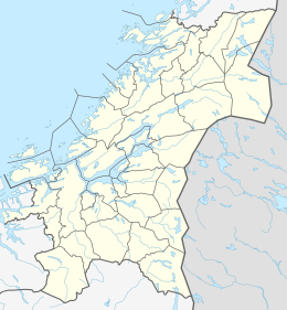
12:
11:
5:
443:
441:
433:
432:
427:
417:
416:
411:
410:
390:
376:
341:
340:
338:
335:
334:
333:
326:
323:
306:
303:
299:Herlaugshaugen
275:
272:
220:
219:
214:
210:
209:
204:
200:
199:
194:
191:
190:
189:Administration
186:
185:
182:
178:
177:
174:
170:
169:
166:
162:
161:
129:
125:
124:
115:
111:
110:
106:
105:
95:
89:
88:
81:
80:
74:
73:
72:
71:
62:
56:
55:
48:
47:
41:
40:
39:
38:
37:
34:
33:
30:
15:
13:
10:
9:
6:
4:
3:
2:
442:
431:
428:
426:
423:
422:
420:
406:
405:
400:
394:
391:
386:
380:
377:
366:
362:
361:
356:
349:
347:
343:
336:
332:
329:
328:
324:
322:
320:
316:
312:
304:
302:
300:
297:
293:
289:
285:
284:cave drawings
281:
273:
271:
269:
265:
261:
257:
252:
250:
246:
242:
238:
234:
230:
226:
218:
215:
211:
208:
205:
201:
197:
192:
187:
183:
179:
175:
171:
167:
163:
158:
130:
126:
123:
119:
116:
112:
107:
96:Leka (Norway)
78:
45:
35:
28:
23:
430:Leka, Norway
403:
393:
379:
368:. Retrieved
358:
318:
314:
308:
296:burial mound
277:
253:
227:is the main
224:
223:
213:Municipality
195:
288:Solsem cave
264:Leka Church
152: /
128:Coordinates
419:Categories
399:Rygh, Oluf
370:2018-05-05
337:References
292:Viking Age
140:11°38′59″E
137:65°05′49″N
311:Old Norse
237:Trøndelag
207:Trøndelag
118:Trøndelag
109:Geography
401:(1903).
325:See also
268:Lekamøya
239:county,
114:Location
286:in the
274:History
258:is the
245:Madsøya
355:"Leka"
294:, the
280:island
256:Leknes
249:Austra
241:Norway
229:island
203:County
196:Norway
173:Length
122:Norway
319:lekke
181:Width
315:Leka
309:The
305:Name
278:The
233:Leka
225:Leka
217:Leka
165:Area
90:Leka
57:Leka
20:Leka
231:in
421::
357:.
345:^
120:,
373:.
Text is available under the Creative Commons Attribution-ShareAlike License. Additional terms may apply.