20:
60:
46:
68:
36:
294:, if all Icelanders should become Christians, a messenger came running from Hellisheiði and called out: “There is a fire up there.” After the decision was made, that all Icelanders—willing or not—should leave the pagan gods behind, some said that it were the wrath of the pagan gods that had caused the eruption.
244:
But actually, the Svínahraun is composed of 3 lava layers, all from the same volcanic system, the
Brennisteinsfjöll, but from different times. The lowermost layer is the 5000 year old Leitahraun, in between is a 2000 year old lava, more or less from the same time as the eruptions in the neighbouring
216:
This small volcano produced an astonishing quantity of lavas reaching like a girdle over the peninsula of
Reykjanes, entering the sea to the north next to the present capital city of Iceland
232:
Part of the
Leitahraun lava flows travelled to the west against the valley opening between Sauðadalahnúkar and Lambafell and then to the north. People of the region call the lava field here
334:
This Elliðahraun travelled about 27 km down to today’s
Reykjavík, and on its way it initiated explosions on a swamp or more probably on small lake which produced the
580:
434:
For detailed maps of the region see eg. pp. 32 and 84 in: Þór Vigfússon: Í Árnesþingi vestanverðu. Ferðafélag Íslands Árbók 2003. Reykjavík 2003.
422:
560:
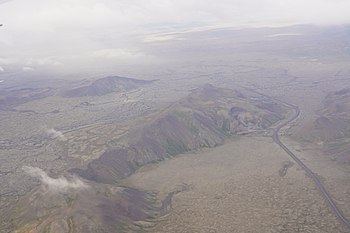
27:: Lambafell in the foreground, behind it to the left the valley with the low shield of Leitin, Leitarhraun lavas and small craters of the
487:
575:
399:
339:
39:
555:
516:
425:
Sverrir Hólmarsson, etal.: Icelandic Online
Dictionary and Readings. University of Wisconsin. Retrieved 29 July 2020.
423:
http://digicoll.library.wisc.edu/cgi-bin/IcelOnline/IcelOnline.TEId-idx?type=entry&eid=leiti&q1=Leiti
203:
59:
45:
72:
19:
395:
570:
282:(“Christianisation-Lava”), is connected to a special story: When in June of the year 1000, Christian
199:
183:
28:
307:
403:
379:
50:
507:
Björn Hróarsson: Hellahandbókin. Leiðsögn um 77 Íslenska hraunhella. Reykjavík 2008, pp. 107 – 123
565:
374:
366:
in the direction of
Hellisheiði and again on its western side. They are under nature protection.
358:
318:
302:
263:
254:
237:
178:
169:
160:
151:
119:
113:
91:
466:Þór Vigfússon: Í Árnesþingi vestanverðu. Ferðafélag Íslands Árbók 2003. Reykjavík 2003, pp.13-15
372:
The southern
Leitahraun produced a.o. multi colored lava tubes of which the best known are Búri
448:
Thor
Thordarson, Armann Hoskuldsson: Iceland. Classic geology of Europe 3. Harpenden 2002, p.56
298:
210:
67:
383:
323:
96:
76:
24:
549:
406:
lava tube which can be visited with guided tours are well known visitor attractions.
335:
291:
35:
217:
369:
The
Hringvegur itself is also for a good part constructed on top of these lavas.
349:
The same lava flow branch produced other interesting landforms like the group of
142:
and looking to the west, the volcano is to be seen in a broad valley between the
297:
Some parts of the
Leitahraun travelled to the south, over the mountain pass of
363:
343:
143:
139:
531:
518:
382:, situated between the south coast of Reykjanes and the pass of Þrengsli on
132:
53:
498:
Snæbjörn Guðmundsson: Vegavísir um jarðfræði Íslands. Reykjavík 2015, p. 48
457:
Snæbjörn Guðmundsson: Vegavísir um jarðfræði Íslands. Reykjavík 2015, p. 42
195:
488:
Tröllabörn-Lækjarbotnum. Friðyst svæði. Suðvesturland. Umhverfisstofnun.
475:
350:
342:. The pseudocraters are located immediately at the western side of the
246:
100:
283:
287:
224:. Today, these lavas are partially covered by younger lava flows.
66:
58:
44:
34:
306:
and reached the coast not far from today’s fisher village of
228:
Lava flows and fields: Leitahraun, Svínahraun, Elliðahraun
394:
Whereas the volcano itself is rather remote, some of its
313:
Part of the northern Leitahraun flows is also called
111:
Leitin ("the hills") is sometimes also called Leiti
123:after its eruption products (“the lava of Leiti”).
198:shield volcano Leitin is itself also part of the
209:It originated in a probably long drawn, mostly
326:where outcrops are to be found in the valley.
322:, because it followed the course of the river
135:peninsula some 25 km south of Reykjavík.
8:
444:
442:
440:
278:Acc. to Medieval sources, this lava, the
18:
415:
346:when entering the city from the south.
249:system, and the uppermost layer is the
220:as well as to the south in the bay of
131:The lava shield is located on the big
476:https://ferlir.is/kristnitokuhraun-2/
373:
357:
317:
301:
262:
253:
236:
177:
168:
159:
150:
118:
112:
90:
7:
63:In the lava tube of Raufarhólshellir
330:Other connected volcanic landforms
14:
581:Brennisteinsfjöll Volcanic System
255:[ˈkʰrɪstnɪˌtʰœːkʏˌr̥œyːn]
200:Brennisteinsfjöll volcanic system
164:and behind some small cones, the
161:[ˈsœyːðaˌtaːlaˌn̥uːkar̥]
264:[ˈsviːnaˌr̥œynsˌprʏːnɪ]
1:
267:emitted by the small craters
561:Shield volcanoes of Iceland
402:rootless cone group or the
359:[ˈtʰrœtlaˌpœ(r)tn̥]
597:
362:, some 10 km up the
319:[ˈɛtlɪːðaˌr̥œyːn]
179:[ˈsɪðrɪˈɛltˌpɔrk]
238:[ˈsviːnaˌr̥œyːn]
182:, eruptive vents of the
120:[ˈleiːtaˌr̥œyːn]
117:("hills") or Leitahraun
88:Icelandic pronunciation:
576:Reykjanes Volcanic Belt
532:64.008056°N 21.543611°W
204:Reykjanes Volcanic Belt
138:When travelling on the
213:, ca. 5000 years ago.
155:with its quarries and
152:[ˈlampaˌfɛtl̥]
80:
73:(volcanogenic) tumulus
64:
56:
42:
32:
537:64.008056; -21.543611
286:were discussing with
202:and therefore of the
190:Geology and volcanism
70:
62:
48:
38:
23:Aerial photograph of
22:
556:Volcanoes of Iceland
303:[ˈθreiŋstlɪ]
99:in the southwest of
16:Small shield volcano
528: /
390:Visitor attractions
75:in the foreground,
71:Leitarhraun with a
275:in the year 1000.
92:[ˈleiːtɪn]
81:
65:
57:
43:
33:
396:eruption products
211:effusive eruption
186:volcanic system.
184:Brennisteinsfjöll
170:[ˈnɪrðrɪ]
114:[ˈleiːtɪ]
79:in the background
29:Brennisteinsfjöll
588:
543:
542:
540:
539:
538:
533:
529:
526:
525:
524:
521:
508:
505:
499:
496:
490:
485:
479:
473:
467:
464:
458:
455:
449:
446:
435:
432:
426:
420:
404:Raufarhólshellir
380:Raufarhólshellir
377:
375:[ˈpuːrɪ]
361:
321:
305:
280:Kristnitökuhraun
266:
260:Svínahraunsbruni
257:
251:Kristnitökuhraun
240:
181:
172:
163:
154:
122:
116:
94:
89:
51:Raufarhólshellir
596:
595:
591:
590:
589:
587:
586:
585:
546:
545:
536:
534:
530:
527:
522:
519:
517:
515:
514:
512:
511:
506:
502:
497:
493:
486:
482:
474:
470:
465:
461:
456:
452:
447:
438:
433:
429:
421:
417:
412:
392:
332:
230:
192:
157:Sauðadalahnúkar
129:
109:
87:
31:volcanic system
17:
12:
11:
5:
594:
592:
584:
583:
578:
573:
568:
563:
558:
548:
547:
510:
509:
500:
491:
480:
468:
459:
450:
436:
427:
414:
413:
411:
408:
391:
388:
331:
328:
229:
226:
191:
188:
128:
125:
108:
105:
97:shield volcano
15:
13:
10:
9:
6:
4:
3:
2:
593:
582:
579:
577:
574:
572:
569:
567:
564:
562:
559:
557:
554:
553:
551:
544:
541:
504:
501:
495:
492:
489:
484:
481:
477:
472:
469:
463:
460:
454:
451:
445:
443:
441:
437:
431:
428:
424:
419:
416:
409:
407:
405:
401:
397:
389:
387:
385:
381:
376:
370:
367:
365:
360:
356:
352:
347:
345:
341:
337:
336:rootless cone
329:
327:
325:
320:
316:
311:
309:
304:
300:
295:
293:
289:
285:
281:
276:
274:
273:Syðri Eldborg
270:
265:
261:
256:
252:
248:
242:
239:
235:
227:
225:
223:
219:
214:
212:
207:
205:
201:
197:
189:
187:
185:
180:
176:
175:Syðri Eldborg
171:
167:
162:
158:
153:
149:
145:
141:
136:
134:
126:
124:
121:
115:
106:
104:
102:
98:
95:) is a small
93:
85:
78:
74:
69:
61:
55:
52:
47:
41:
37:
30:
26:
21:
513:
503:
494:
483:
471:
462:
453:
430:
418:
393:
371:
368:
354:
348:
333:
314:
312:
296:
279:
277:
272:
268:
259:
250:
243:
233:
231:
221:
215:
208:
193:
174:
165:
156:
147:
137:
130:
110:
83:
82:
571:Lava fields
535: /
384:Hellisheiði
315:Elliðahraun
308:Þorlákshöfn
25:Hellisheiði
550:Categories
523:21°32′37″W
520:64°00′29″N
410:References
364:Hringvegur
355:Tröllabörn
344:Hringvegur
292:Þingvellir
234:Svínahraun
146:ridges of
144:palagonite
140:hringvegur
566:Reykjanes
478:Ferlir.is
400:Rauðhólar
398:like the
353:, called
340:Rauðhólar
218:Reykjavík
148:Lambafell
133:Reykjanes
127:Geography
54:lava tube
40:Rauðhólar
351:hornitos
324:Elliðaár
299:Þrengsli
290:ones at
222:Selvogur
196:Holocene
77:Bláfjöll
284:vikings
247:Hengill
101:Iceland
49:Within
338:group
166:Nyrðri
84:Leitin
288:pagan
269:Nyðri
378:and
271:and
194:The
173:and
107:Name
258:or
552::
439:^
386:.
310:.
241:.
206:.
103:.
86:(
Text is available under the Creative Commons Attribution-ShareAlike License. Additional terms may apply.