36:
460:
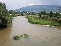
For the remaining 15 km (9 mi), the
Lepenac flows through the low Skopje valley, part of the composite valley of the river Vardar. Immediately entering the Greater Skopje area, it receives several small streams from the left, from the Skopska Crna Gora mountain. It passes next to the ruins
502:
The river has a potential for hydroelectrical production, but even though being a part of the former Ibar-Lepenac
Hydrosystem project, it is not much used, either for energy production or irrigation.
465:, but has no major settlements on its Macedonian course, before it reaches the northern suburbs of Skopje, Bardovci and Novo Selo, and empties into the Vardar at the Skopje's northern borough of
311:
484:, with its own drainage area of 770 km (297 sq mi) (695 km or 268 sq mi in Kosovo, 75 km or 29 sq mi in Macedonia). It is not navigable.
448:
are located in the gorge. After Hani i Elezit, the
Lepenac becomes a border river between Kosovo and Macedonia, before it leaves the gorge after the village of
602:
398:
in the north, next to the villages of Biti e Poshtëme, Gotovushë, Brod and
Doganaj, where the river makes an elbow turn to the south, entering the
775:
444:
terrain. Higher parts of the gorge are actually formed by the ancient outflow of the now extinct lake. The village of
Pustenik and small town of
770:
765:
538:
760:
750:
575:
561:
212:
595:
367:, at an altitude of 1,833 m (6,014 ft). It flows eastward, into the region of Sirinićka župa, between the
466:
35:
755:
588:
611:
686:
726:
678:
303:
75:
395:
662:
571:
557:
506:
429:
384:
360:
295:
150:
60:
20:
488:
418:
375:
from the south. From the Šar
Mountains it receives many small tributaries, most notably the
372:
321:
90:
718:
539:"Raport - Ndikimi I shfrytëzuesve të rërës dhe zhavorit në gjendjen mjedisore të lumenjve"
425:
339:
198:
118:
368:
694:
481:
449:
410:
409:, flows next to the villages of Kovaçefc and Bob, and receives its major tributary the
406:
744:
710:
445:
424:
The gorge, as the narrowest part of the
Lepenac river valley, is located between the
646:
518:
670:
654:
175:
622:
478:
414:
282:
227:
214:
514:
437:
388:
496:
492:
380:
630:
510:
364:
702:
433:
399:
343:
335:
278:
194:
190:
154:
113:
580:
544:. Prishtinë: Agjencioni për mbrojtjen e mjedisit të Kosovës. 2022.
462:
441:
436:
valley. The gorge is 23 km (14 mi) long, carved in the
394:
The
Lepenac continues between the Šar Mountains in the south and
371:
mountain from the north and alongside the northern slopes of the
584:
452:
and leaves Kosovo after the course of 60 km (37 mi).
405:
For several kilometers the
Lepenac flows parallel to the
342:, a 75 km (47 mi) long left tributary to the
274:
269:
261:
253:
243:
204:
184:
174:
160:
144:
136:
127:
106:
101:
45:
28:
517:drainage basins, but the canal was covered after
379:, as it passes next to the villages of Sevce and
67:
568:Enciklopedijski geografski leksikon Jugoslavije
513:rivers via a canal, thus connecting Aegean and
432:on the east and connects the Kosovo field and
52:
596:
509:, as the Nerodime connected both Lepenac and
491:is a route for both the road and the railway
329:
82:
8:
469:at an altitude of 262 m (860 ft).
603:
589:
581:
505:The Lepenac was a part of the artificial
387:and a small town and regional center of
530:
25:
166:1,833 m (6,014 ft) (source)
7:
19:For the village in Montenegro, see
16:River in Kosovo and North Macedonia
556:, Third edition (1985); Prosveta;
14:
265:770 km (300 sq mi)
34:
359:The Lepenac springs out on the
776:International rivers of Europe
206: • coordinates
1:
771:Geography of Prizren District
766:Geography of Ferizaj District
554:Mala Prosvetina Enciklopedija
413:from the left at the town of
128:Physical characteristics
245: • elevation
162: • elevation
477:The Lepenac belongs to the
330:
186: • location
146: • location
792:
566:Jovan Đ. Marković (1990):
417:, at the beginning of the
18:
761:Rivers of North Macedonia
751:Tributaries of the Vardar
618:
334:) is a river in southern
325:
307:
170:
132:
83:
68:
40:Lepenac through Macedonia
33:
249:262 m (860 ft)
461:of the ancient city of
257:75 km (47 mi)
570:; Svjetlost-Sarajevo;
363:, east of the city of
299:
53:
727:Lumbardhi i Prizrenit
383:, the ski resort of
687:Lumbardhi i Deçanit
270:Basin features
228:42.0128°N 21.3831°E
224: /
396:Nerodimka mountain
738:
737:
731:
723:
715:
707:
699:
691:
683:
679:Lumbardhi i Pejës
675:
667:
643:
430:Skopska Crna Gora
288:
287:
21:Lepenac, Mojkovac
783:
756:Rivers of Kosovo
729:
721:
713:
705:
697:
689:
681:
673:
665:
659:
651:
641:
635:
627:
612:Rivers of Kosovo
605:
598:
591:
582:
546:
545:
543:
535:
428:on the west and
333:
327:
319:
318:
317:
316:
314:
239:
238:
236:
235:
234:
233:42.0128; 21.3831
229:
225:
222:
221:
220:
217:
163:
147:
94:
86:
85:
79:
71:
70:
64:
56:
38:
26:
791:
790:
786:
785:
784:
782:
781:
780:
741:
740:
739:
734:
657:
649:
633:
625:
614:
609:
550:
549:
541:
537:
536:
532:
527:
475:
473:Characteristics
458:
456:North Macedonia
426:Sharr Mountains
361:Oshlak mountain
357:
352:
340:North Macedonia
312:
310:
309:
308:
246:
232:
230:
226:
223:
218:
215:
213:
211:
210:
207:
199:North Macedonia
187:
161:
151:Oshlak mountain
145:
123:
119:North Macedonia
97:
88:
73:
58:
41:
24:
17:
12:
11:
5:
789:
787:
779:
778:
773:
768:
763:
758:
753:
743:
742:
736:
735:
733:
732:
724:
716:
708:
700:
692:
684:
676:
668:
663:Binačka Morava
660:
652:
644:
636:
628:
619:
616:
615:
610:
608:
607:
600:
593:
585:
579:
578:
564:
548:
547:
529:
528:
526:
523:
482:drainage basin
474:
471:
457:
454:
407:Nerodime river
356:
353:
351:
348:
286:
285:
276:
272:
271:
267:
266:
263:
259:
258:
255:
251:
250:
247:
244:
241:
240:
208:
205:
202:
201:
188:
185:
182:
181:
178:
172:
171:
168:
167:
164:
158:
157:
148:
142:
141:
138:
134:
133:
130:
129:
125:
124:
122:
121:
116:
110:
108:
104:
103:
99:
98:
96:
95:
80:
65:
49:
47:
43:
42:
39:
31:
30:
15:
13:
10:
9:
6:
4:
3:
2:
788:
777:
774:
772:
769:
767:
764:
762:
759:
757:
754:
752:
749:
748:
746:
728:
725:
720:
717:
712:
709:
704:
701:
696:
693:
688:
685:
680:
677:
672:
669:
664:
661:
656:
653:
648:
645:
640:
637:
632:
629:
624:
621:
620:
617:
613:
606:
601:
599:
594:
592:
587:
586:
583:
577:
576:86-01-02651-6
573:
569:
565:
563:
562:86-07-00001-2
559:
555:
552:
551:
540:
534:
531:
524:
522:
520:
516:
512:
508:
503:
500:
498:
494:
490:
489:Kaçanik gorge
485:
483:
480:
472:
470:
468:
464:
455:
453:
451:
447:
446:Hani i Elezit
443:
439:
435:
431:
427:
422:
420:
419:Kaçanik Gorge
416:
412:
408:
403:
401:
397:
392:
390:
386:
382:
378:
374:
373:Šar Mountains
370:
366:
362:
354:
349:
347:
345:
341:
338:and northern
337:
332:
323:
315:
305:
301:
297:
293:
284:
280:
277:
273:
268:
264:
260:
256:
252:
248:
242:
237:
209:
203:
200:
196:
192:
189:
183:
179:
177:
173:
169:
165:
159:
156:
152:
149:
143:
139:
135:
131:
126:
120:
117:
115:
112:
111:
109:
105:
100:
92:
81:
77:
66:
62:
55:
51:
50:
48:
44:
37:
32:
27:
22:
638:
567:
553:
533:
519:World War II
504:
501:
486:
476:
467:Ǵorče Petrov
459:
423:
404:
393:
376:
358:
291:
289:
507:bifurcation
275:Progression
231: /
46:Native name
745:Categories
626:(111.5 km)
623:White Drin
525:References
479:Aegean Sea
304:Macedonian
283:Aegean Sea
262:Basin size
219:21°22′59″E
216:42°00′46″N
76:Macedonian
658:(76.8 km)
515:Black Sea
499:-Skopje.
438:limestone
385:Brezovica
377:Suva reka
107:Countries
695:Nerodime
642:(109 km)
634:(110 km)
497:Pristina
493:Kraljevo
450:Seçishtë
411:Nerodime
381:Jazhincë
296:Albanian
102:Location
61:Albanian
730:(18 km)
722:(23 km)
714:(37 km)
711:Mirusha
706:(38 km)
698:(41 km)
690:(53 km)
682:(56 km)
674:(60 km)
666:(67 km)
650:(85 km)
639:Lepenac
631:Sitnica
511:Sitnica
415:Kaçanik
402:field.
365:Prizren
346:river.
331:Lepenac
326:Лепенац
322:Serbian
313:Лепенец
300:Lepenci
292:Lepenac
91:Serbian
84:Лепенац
69:Лепенац
54:Lepenci
29:Lepenac
703:Erenik
574:
560:
434:Skopje
400:Kosovo
389:Štrpce
355:Kosovo
350:Course
344:Vardar
336:Kosovo
279:Vardar
254:Length
195:Skopje
191:Vardar
180:
155:Kosovo
140:
137:Source
114:Kosovo
87:
72:
57:
719:Krena
671:Klina
655:Llapi
542:(PDF)
463:Scupi
442:slate
193:, at
176:Mouth
647:Ibar
572:ISBN
558:ISBN
487:The
440:and
290:The
369:Žar
747::
521:.
421:.
391:.
328:,
324::
320:;
306::
302:;
298::
281:→
197:,
153:,
604:e
597:t
590:v
495:-
294:(
93:)
89:(
78:)
74:(
63:)
59:(
23:.
Text is available under the Creative Commons Attribution-ShareAlike License. Additional terms may apply.