28:
61:
235:
228:
184:
559:
585:
221:
358:
55:
423:
549:
313:
403:
564:
496:
511:
109:
140:
244:
98:
476:
285:
408:
373:
539:
388:
318:
456:
163:
529:
491:
398:
363:
308:
486:
393:
348:
303:
252:
121:
519:
501:
428:
328:
298:
534:
413:
343:
338:
333:
323:
265:
579:
481:
418:
353:
293:
466:
368:
270:
133:
105:
27:
544:
448:
433:
383:
275:
524:
471:
461:
438:
113:
199:
186:
554:
260:
90:
213:
94:
129:
117:
139:
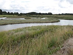
There is no public access to the site but it can be viewed from the
125:
217:
97:. It is owned by Suffolk Yacht Harbour Ltd and managed by the
104:
This area of open water and saltmarsh on the bank of the
108:
was formed when the sea wall was breached during the
510:
447:
284:
251:
76:
68:
54:
46:
38:
20:
229:
8:
89:is a 5 hectare nature reserve south-east of
236:
222:
214:
17:
152:
158:
156:
7:
37:
112:. The birds are diverse, including
14:
45:
26:
75:
67:
1:
424:Sutton and Hollesley Commons
261:Arger Fen and Spouse's Vale
132:. There are plants such as
602:
550:Norah Hanbury-Kelk Meadows
314:Carlton and Oulton Marshes
34:
25:
497:Redgrave and Lopham Fens
166:. Suffolk Wildlife Trust
110:North Sea flood of 1953
586:Suffolk Wildlife Trust
245:Suffolk Wildlife Trust
99:Suffolk Wildlife Trust
80:Suffolk Wildlife Trust
477:Fox Fritillary Meadow
141:Stour and Orwell Walk
319:Church Farm Marshes
196: /
457:Black Bourn Valley
409:Simpson's Saltings
374:Hutchison's Meadow
164:"Levington Lagoon"
50:Levington, Suffolk
573:
572:
540:Market Weston Fen
530:Knettishall Heath
492:Papermill Reedbed
399:Newbourne Springs
364:Hazlewood Marshes
122:spotted redshanks
84:
83:
593:
487:Mickfield Meadow
394:Martlesham Wilds
389:Martins' Meadows
379:Levington Lagoon
349:Framlingham Mere
304:Bromeswell Green
238:
231:
224:
215:
211:
210:
208:
207:
206:
201:
200:52.003°N 1.259°E
197:
194:
193:
192:
189:
176:
175:
173:
171:
160:
87:Levington Lagoon
64:
30:
21:Levington Lagoon
18:
601:
600:
596:
595:
594:
592:
591:
590:
576:
575:
574:
569:
565:Wangford Warren
520:Bradfield Woods
506:
443:
429:Trimley Marshes
329:Darsham Marshes
299:Blaxhall Common
280:
247:
242:
204:
202:
198:
195:
190:
187:
185:
183:
182:
180:
179:
169:
167:
162:
161:
154:
149:
77:Managed by
60:
12:
11:
5:
599:
597:
589:
588:
578:
577:
571:
570:
568:
567:
562:
560:Thelnetham Fen
557:
552:
547:
542:
537:
535:Lackford Lakes
532:
527:
522:
516:
514:
508:
507:
505:
504:
499:
494:
489:
484:
479:
474:
469:
464:
459:
453:
451:
445:
444:
442:
441:
436:
431:
426:
421:
416:
414:Sizewell Belts
411:
406:
401:
396:
391:
386:
381:
376:
371:
366:
361:
356:
351:
346:
344:Foxburrow Farm
341:
339:Dunwich Forest
336:
334:Dingle Marshes
331:
326:
324:Castle Marshes
321:
316:
311:
309:Captain's Wood
306:
301:
296:
290:
288:
282:
281:
279:
278:
273:
268:
263:
257:
255:
249:
248:
243:
241:
240:
233:
226:
218:
178:
177:
151:
150:
148:
145:
82:
81:
78:
74:
73:
70:
66:
65:
58:
52:
51:
48:
44:
43:
42:Nature reserve
40:
36:
35:
32:
31:
23:
22:
13:
10:
9:
6:
4:
3:
2:
598:
587:
584:
583:
581:
566:
563:
561:
558:
556:
553:
551:
548:
546:
543:
541:
538:
536:
533:
531:
528:
526:
523:
521:
518:
517:
515:
513:
509:
503:
500:
498:
495:
493:
490:
488:
485:
483:
482:Mellis Common
480:
478:
475:
473:
470:
468:
465:
463:
460:
458:
455:
454:
452:
450:
446:
440:
437:
435:
432:
430:
427:
425:
422:
420:
419:Snape Marshes
417:
415:
412:
410:
407:
405:
402:
400:
397:
395:
392:
390:
387:
385:
382:
380:
377:
375:
372:
370:
367:
365:
362:
360:
359:Gunton Warren
357:
355:
354:Gunton Meadow
352:
350:
347:
345:
342:
340:
337:
335:
332:
330:
327:
325:
322:
320:
317:
315:
312:
310:
307:
305:
302:
300:
297:
295:
294:Alde Mudflats
292:
291:
289:
287:
283:
277:
274:
272:
269:
267:
264:
262:
259:
258:
256:
254:
250:
246:
239:
234:
232:
227:
225:
220:
219:
216:
212:
209:
205:52.003; 1.259
165:
159:
157:
153:
146:
144:
142:
137:
135:
131:
127:
123:
119:
115:
111:
107:
102:
100:
96:
92:
88:
79:
71:
63:
59:
57:
53:
49:
41:
33:
29:
24:
19:
16:
512:West Suffolk
502:Winks Meadow
467:Brooke House
378:
369:Hen Reedbeds
286:East Suffolk
271:Cornard Mere
181:
168:. Retrieved
138:
134:sea lavender
106:River Orwell
103:
86:
85:
15:
545:Mickle Mere
449:Mid Suffolk
434:Reydon Wood
384:Lound Lakes
276:Groton Wood
266:Bull's Wood
203: /
114:greenshanks
525:Hopton Fen
472:Combs Wood
462:Bonny Wood
439:Roydon Fen
404:North Cove
188:52°00′11″N
147:References
72:5 hectares
555:Old Broom
191:1°15′32″E
170:14 August
91:Levington
580:Category
62:TM238389
47:Location
253:Babergh
130:dunlins
118:dunlins
95:Suffolk
56:OS grid
126:pipits
172:2017
128:and
69:Area
39:Type
93:in
582::
155:^
143:.
136:.
124:,
120:,
116:,
101:.
237:e
230:t
223:v
174:.
Text is available under the Creative Commons Attribution-ShareAlike License. Additional terms may apply.