57:
621:
42:
361:
The township is governed by a three-member board of trustees, who are elected in
November of odd-numbered years to a four-year term beginning on the following January 1. Two are elected in the year after the presidential election and one is elected in the year before it. There is also an elected
362:
township fiscal officer, who serves a four-year term beginning on April 1 of the year after the election, which is held in
November of the year before the presidential election. Vacancies in the fiscal officership or on the board of trustees are filled by the remaining trustees.
56:
70:
559:
353:
Licking
Township was organized before 1806. By the 1830s, Licking Township contained two churches, four mills, and two of the largest ancient mounds in the county.
1127:
810:
715:
820:
805:
795:
780:
755:
293:
745:
740:
735:
305:
765:
750:
281:
785:
775:
311:
228:
998:
825:
815:
800:
790:
770:
730:
705:
347:
317:
299:
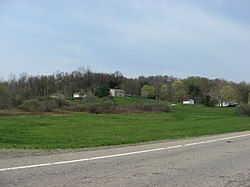
725:
720:
287:
552:
323:
238:
893:
963:
408:
203:
545:
386:
1013:
532:
537:
41:
434:
1132:
988:
458:
1794. History of
Muskingum County, Ohio, with illustrations and biographical sketches of prominent men and pioneers
266:
710:
124:
102:
835:
858:
687:
569:
258:
129:
1104:
983:
913:
863:
848:
213:
47:
1097:
1053:
1048:
1003:
878:
331:
978:
933:
923:
843:
456:
993:
908:
903:
888:
666:
650:
511:
1038:
928:
640:
610:
591:
479:
1023:
1018:
1008:
958:
918:
898:
681:
655:
968:
948:
943:
853:
697:
632:
335:
254:
32:
1121:
1043:
973:
953:
868:
671:
660:
645:
1074:
1033:
1028:
473:
938:
676:
602:
584:
277:
Located on the western edge of the county, it borders the following townships:
1058:
112:
85:
72:
194:
1088:‡This populated place also has portions in an adjacent county or counties
507:
503:
499:
409:"Licking township, Muskingum County, Ohio - Census Bureau Profile"
220:
199:
620:
527:
330:
No municipalities are located in
Licking Township, although the
262:
117:
541:
619:
382:
430:
346:
Statewide, the only other
Licking Township is located in
1083:
1067:
877:
834:
696:
631:
601:
237:
227:
210:
193:
185:
177:
172:
164:
156:
148:
140:
135:
123:
111:
101:
23:
475:The Ohio Gazetteer, or, a Topographical Dictionary
61:Location of Licking Township in Muskingum County
553:
8:
560:
546:
538:
338:lies in the western part of the township.
20:
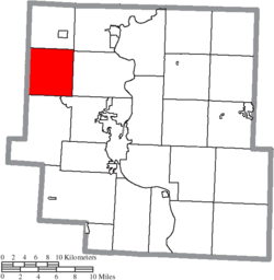
624:Map of Ohio highlighting Muskingum County
25:Licking Township, Muskingum County, Ohio
371:
226:
192:
171:
163:
134:
100:
65:
53:
38:
461:. F.J. Everhart & Co. p. 402.
377:
375:
236:
209:
184:
176:
155:
147:
139:
122:
110:
7:
269:found 2,352 people in the township.
1128:Townships in Muskingum County, Ohio
152:25.1 sq mi (64.9 km)
144:25.8 sq mi (66.7 km)
568:Municipalities and communities of
14:
312:Hopewell Township, Licking County
160:0.7 sq mi (1.8 km)
318:Hanover Township, Licking County
55:
40:
387:United States Geological Survey
18:Township in Ohio, United States
383:"US Board on Geographic Names"
324:Perry Township, Licking County
1:
478:. Scott and Wright. pp.
411:. United States Census Bureau
435:United States Census Bureau
1149:
253:is one of the twenty-five
1093:
617:
582:
66:
54:
39:
30:
332:unincorporated community
168:761 ft (232 m)
472:Kilbourn, John (1833).
455:Everhart, F.J. (1882).
625:
571:Muskingum County, Ohio
265:, United States. The
623:
514:. Accessed 4/30/2009.
431:"U.S. Census website"
212: • Summer (
189:91/sq mi (35/km)
86:40.05639°N 82.14083°W
1106:United States portal
989:Mattingly Settlement
186: • Density
91:40.05639; -82.14083
82: /
1068:Former communities
626:
389:. October 25, 2007
326:- northwest corner
314:- southwest corner
294:Muskingum Township
178: • Total
157: • Water
141: • Total
1133:Townships in Ohio
1115:
1114:
512:Ohio Revised Code
306:Hopewell Township
248:
247:
149: • Land
1140:
1107:
1100:
859:North Zanesville
688:South Zanesville
622:
594:
587:
577:
572:
562:
555:
548:
539:
515:
497:
491:
490:
488:
486:
469:
463:
462:
452:
446:
445:
443:
441:
427:
421:
420:
418:
416:
405:
399:
398:
396:
394:
379:
342:Name and history
282:Jackson Township
259:Muskingum County
251:Licking Township
217:
97:
96:
94:
93:
92:
87:
83:
80:
79:
78:
75:
59:
44:
21:
1148:
1147:
1143:
1142:
1141:
1139:
1138:
1137:
1118:
1117:
1116:
1111:
1105:
1098:
1089:
1079:
1063:
880:
873:
830:
692:
627:
615:
597:
592:
585:
578:
575:
570:
566:
524:
519:
518:
498:
494:
484:
482:
471:
470:
466:
454:
453:
449:
439:
437:
429:
428:
424:
414:
412:
407:
406:
402:
392:
390:
381:
380:
373:
368:
359:
344:
275:
211:
90:
88:
84:
81:
76:
73:
71:
69:
68:
62:
50:
48:State Route 146
35:
26:
19:
12:
11:
5:
1146:
1144:
1136:
1135:
1130:
1120:
1119:
1113:
1112:
1110:
1109:
1102:
1094:
1091:
1090:
1087:
1085:
1081:
1080:
1078:
1077:
1071:
1069:
1065:
1064:
1062:
1061:
1056:
1051:
1046:
1041:
1036:
1031:
1026:
1021:
1016:
1011:
1006:
1001:
999:Mount Sterling
996:
991:
986:
984:Marquand Mills
981:
976:
971:
966:
961:
956:
951:
946:
941:
936:
931:
926:
921:
916:
914:Chandlersville
911:
906:
901:
896:
891:
885:
883:
879:Unincorporated
875:
874:
872:
871:
866:
864:Pleasant Grove
861:
856:
851:
849:East Fultonham
846:
840:
838:
832:
831:
829:
828:
823:
818:
813:
808:
803:
798:
793:
788:
783:
778:
773:
768:
763:
758:
753:
748:
743:
738:
733:
728:
723:
718:
713:
708:
702:
700:
694:
693:
691:
690:
685:
679:
674:
669:
664:
658:
653:
648:
643:
637:
635:
629:
628:
618:
616:
614:
613:
607:
605:
599:
598:
583:
580:
579:
567:
565:
564:
557:
550:
542:
536:
535:
530:
528:County website
523:
522:External links
520:
517:
516:
492:
464:
447:
422:
400:
370:
369:
367:
364:
358:
355:
348:Licking County
343:
340:
328:
327:
321:
315:
309:
303:
300:Falls Township
297:
291:
285:
274:
271:
246:
245:
242:
235:
234:
231:
225:
224:
218:
208:
207:
197:
191:
190:
187:
183:
182:
179:
175:
174:
170:
169:
166:
162:
161:
158:
154:
153:
150:
146:
145:
142:
138:
137:
133:
132:
127:
121:
120:
115:
109:
108:
105:
99:
98:
64:
63:
60:
52:
51:
45:
37:
36:
31:
28:
27:
24:
17:
13:
10:
9:
6:
4:
3:
2:
1145:
1134:
1131:
1129:
1126:
1125:
1123:
1108:
1103:
1101:
1096:
1095:
1092:
1086:
1082:
1076:
1073:
1072:
1070:
1066:
1060:
1057:
1055:
1054:Young Hickory
1052:
1050:
1049:White Cottage
1047:
1045:
1042:
1040:
1037:
1035:
1032:
1030:
1027:
1025:
1022:
1020:
1017:
1015:
1012:
1010:
1007:
1005:
1004:Moxahala Park
1002:
1000:
997:
995:
992:
990:
987:
985:
982:
980:
977:
975:
972:
970:
967:
965:
962:
960:
957:
955:
952:
950:
947:
945:
942:
940:
937:
935:
932:
930:
927:
925:
922:
920:
917:
915:
912:
910:
907:
905:
902:
900:
897:
895:
892:
890:
887:
886:
884:
882:
876:
870:
867:
865:
862:
860:
857:
855:
852:
850:
847:
845:
842:
841:
839:
837:
833:
827:
824:
822:
819:
817:
814:
812:
809:
807:
804:
802:
799:
797:
794:
792:
789:
787:
784:
782:
779:
777:
774:
772:
769:
767:
764:
762:
759:
757:
754:
752:
749:
747:
744:
742:
739:
737:
734:
732:
729:
727:
724:
722:
719:
717:
714:
712:
709:
707:
704:
703:
701:
699:
695:
689:
686:
683:
680:
678:
675:
673:
670:
668:
665:
662:
659:
657:
654:
652:
649:
647:
644:
642:
639:
638:
636:
634:
630:
612:
609:
608:
606:
604:
600:
596:
595:
588:
581:
576:United States
573:
563:
558:
556:
551:
549:
544:
543:
540:
534:
531:
529:
526:
525:
521:
513:
509:
505:
501:
496:
493:
481:
477:
476:
468:
465:
460:
459:
451:
448:
436:
432:
426:
423:
410:
404:
401:
388:
384:
378:
376:
372:
365:
363:
356:
354:
351:
349:
341:
339:
337:
333:
325:
322:
319:
316:
313:
310:
307:
304:
301:
298:
295:
292:
289:
288:Cass Township
286:
283:
280:
279:
278:
272:
270:
268:
264:
260:
256:
252:
243:
240:
232:
230:
222:
219:
215:
205:
204:Eastern (EST)
201:
198:
196:
188:
180:
167:
159:
151:
143:
131:
128:
126:
119:
116:
114:
107:United States
106:
104:
95:
67:Coordinates:
58:
49:
46:Fields along
43:
34:
29:
22:
16:
979:Licking View
934:Dillon Falls
924:Cottage Hill
844:Duncan Falls
760:
590:
495:
485:December 12,
483:. Retrieved
474:
467:
457:
450:
438:. Retrieved
425:
413:. Retrieved
403:
391:. Retrieved
360:
352:
345:
329:
276:
250:
249:
15:
1099:Ohio portal
994:Meadow Farm
909:Cannelville
904:Bridgeville
889:Adams Mills
881:communities
811:Springfield
716:Brush Creek
667:New Concord
651:Frazeysburg
586:County seat
440:January 31,
393:January 31,
302:- southeast
290:- northeast
267:2020 census
89: /
1122:Categories
1039:Stovertown
929:Darlington
894:Bloomfield
821:Washington
806:Salt Creek
641:Adamsville
611:Zanesville
593:Zanesville
366:References
357:Government
241:feature ID
173:Population
1084:Footnotes
1024:Ruraldale
1019:Rix Mills
1009:Museville
959:High Hill
919:Coal Hill
899:Blue Rock
796:Rich Hill
781:Muskingum
756:Jefferson
711:Blue Rock
698:Townships
682:Roseville
656:Fultonham
533:Misc Info
273:Geography
255:townships
229:FIPS code
195:Time zone
165:Elevation
130:Muskingum
77:82°8′27″W
74:40°3′23″N
969:Ironspot
964:Hopewell
949:Gaysport
944:Freeland
854:Nashport
746:Hopewell
741:Highland
736:Harrison
633:Villages
415:July 31,
336:Nashport
233:39-43470
33:Township
1044:Sundale
974:Irville
954:Gilbert
869:Trinway
766:Madison
761:Licking
751:Jackson
672:Norwich
661:Gratiot
646:Dresden
510:of the
508:§507.01
504:§505.01
500:§503.24
308:- south
284:- north
244:1086724
103:Country
1075:Putnam
1034:Spratt
1029:Sonora
1014:Otsego
786:Newton
776:Monroe
506:, and
320:- west
296:- east
125:County
939:Ellis
826:Wayne
816:Union
801:Salem
791:Perry
771:Meigs
731:Falls
706:Adams
677:Philo
223:(EDT)
221:UTC-4
200:UTC-5
181:2,352
113:State
1059:Zeno
836:CDPs
726:Clay
721:Cass
603:City
487:2013
442:2008
417:2023
395:2008
263:Ohio
239:GNIS
136:Area
118:Ohio
480:274
334:of
257:of
214:DST
1124::
589::
574:,
502:,
433:.
385:.
374:^
350:.
261:,
684:‡
663:‡
561:e
554:t
547:v
489:.
444:.
419:.
397:.
216:)
206:)
202:(
Text is available under the Creative Commons Attribution-ShareAlike License. Additional terms may apply.