446:"The eruption at Capelinhos started on 27 September with a small boiling of water at sea some 1 kilometre (0.62 mi) west of the lighthouse. On 29 September, the intensity increased and became highly explosive. The ejecti of ash (sand and powder) reached frequently 800 metres (2,600 ft) and another time reached more than 1,200 metres (3,900 ft). The column of water vapor reached 3 or 4 kilometres (1.9 or 2.5 mi) in height and exceptionally even more. The violence of the eruption continued for a month. The quantity of ash emitted was so great that it formed a small island with 800 metres (2,600 ft) diameter and 100 metres (330 ft) height (above sea level) in an area that where the profundity was 70 metres (230 ft). There fell, near the lighthouse of Capelinhos and Port of Comprido, a few rocks that were about 30 kilograms (66 lb). The cloud was blown by the wind and because of that ash fell some 20 kilometres (12 mi) from the volcanic chimney. This was the aspect more harmful of the eruption. The quantity of ash fell on land dependent on the direction of the wind. When the wind blew strong from the west, on the 6 and 7 October, there was a panic in the settlements of Canto and Norte Pequeno ( parish of Capelo) which lie about 3 kilometres (1.9 mi) from the volcano. The populations were evacuated. In virtue of the dust scattered in the air (which increased greatly the condensation of the water droplets) the rainfall in the region increased by more the twice the normal, passing from 70 millimetres (2.8 in) to more than 700 millimetres (28 in) per month. The torrential rainfall that fell was another disastrous factor in the region. On 29 October the small island became submerged and it appeared that the activity had terminated. But within the following days it continued, it is unclear whether the activity will return and attain the anterior violence...The rocks expelled by the volcano fell on the buildings of the lighthouse of Capelinhos, puncturing the tile and pavements and breaking glass, sanitary wares and some furniture. The lighthouse had to be closed during the eruption and the personnel evacuated. The work that was in course was, therefore, suspended. The ash and rainfall seaped into the holes in the roof and windows and accumulated in almost all the rooms, damaging the interior floors and paintings. The exterior courtyard was, also, littered with more than 1 metre (3.3 ft) of sand."
460:"Since the volcanic activity decreased in November and December, the main breakdowns were repaired by the Directorate for Lighthouses and in part by the Direcção-Geral dos Edifícios e Monumentos Nacionais, who executed emergency repairs to the tune of 49.611$ 50 to the buildings in order to resist the inclement weather caused by the eruption that persisted for months. In January ashed fell again and (from the Direcção de Obras Públicas) funds were realized (20 contos) to maintain the roofs clean, of which 11.109$ 00 were spent...In February and March, the eruption had an unexpected development. The crater, that was about 1,200 kilometres (750 mi) from the lighthouse, do farol) shifted to a point 500 metres (1,600 ft) closer, the consequence of the rocks, with weights of between 10–300 kilograms (22–661 lb), and which fell in great abundance, that the roof cleaning work was quickly suspended. Many the rocks damaged the buildings, piercing the fibrocement roof. Ash also fell in great abundance...In one night (23–24 March) a 1.9 metres (6.2 ft) layer of ash fell, corresponding to a load of 2,000 kilograms per cubic metre (120 lb/cu ft). The roofs of the residences fell in and the reinforced concrete slab in the machine building was ruined. There is actually in the lighthouse courtyard ash with a layer of 7 metres (23 ft) approximately and this number continues to increase. It was possible with funds received to remove furniture and machinery (work that was completed by personnel from the lighthouse)...In wake of what has occurred, it appears that no further funds should be spent on the lighthouse until the eruption ends. The tower still maintains itself in reasonable conditions, but the volcanic cone, actually 150 metres (490 ft) is increasing a lot, that maybe we will need to review the future location of the lightouse."
32:
31:
404:
42:
181:
310:
392:
476:
440:
The first report by directing engineer of Public Works (Frederico de
Menezes Avelino Machado) occurred on 7 November 1957, to the director of the DGEMN, over the impact of the eruption on the lighthouse. Included in the report was a unique moment in the contemporary history of the archipelago:
347:) did study the elaboration of an "illumination plan" for the archipelago. But, this commission had gotten bogged-down in the issues of budget, changes in government and lack of political will. In the local newspaper, opinions from the Portuguese marines,
655:
Lista de Faróis, Bóias
Luminosas, Radiofaróis, Sinais de Nevoeiro e Sinais Horários e de Mau Tempo, Estações Radiotelegráficas e de Socorro a Náufragos Existentes na Costa de Portugal, nos Arquipélagos dos Açores e Madeira e
336:). Still within this decade, Progressive deputy Miguel António da Silveira received authorization that the construction of the first of these lighthouses would be undertaken, but there were no promises or timelines.
352:
319:" complained to the Government that some lights were need along the islands coast to indicate to navigation that crossed these waters their proximity to land, the loss that occur or the choices to make."
317:
Work on the lighthouse began on 18 April 1894, but for many years the necessity of constructing a beacon on the tip of Faial had been advocated by navigators, officials and public opinion, who:
448:
This description was also accompanied by a photographic journal with regists, captions and dated, to illustrate the more important moments of the event between
September and November 1957.
355:) and Domingos Tasso de Figuerido were bantered about. These considerations, along with the Lighthouse Commission proposal were presented in May 1892 to the Ministry of Public Works (
455:
On 30 April 1958, a new report by
Frederico de Menezes Avelino Machado, accompanied by seven photographic entries, in which he described what had occurred since the last report:
371:
Although government candidates were defeated (and José de
Almeida de Ávila was forced to resign) the work continued, and the lighthouse eventually inaugurated on 1 August 1903.
722:
367:
was released in April 1894. Elections, on 29 April of the same year, saw
Progressive candidates attack the Regenerator plans of José de Almeida de Ávila, stating that
525:
321:
The number of incidents in this region reached a grande scale by the end of the 19th century, with more traffic, but records went as far back as 1678.
89:
712:
369:"shortly the fiasco of the works on the lighthouse of Capelinhos. After starting the election on 29th day, summer quickly ends the work."
717:
437:), the director of the Directorate informed by telegraph the suspension of activities due to the eruption of the Capelinhos volcano.
681:
667:(in Portuguese), vol. I (1st ed.), Ponta Delgada (Azores), Portugal: Observatório Vulcanológico e Geotérmico dos Açores
491:
407:
The main building and tower were buried by ash and rock to the point that today only the second-floor is visible above ground
348:
82:
332:) and Municipal Council, presided by João José da Graça, to establish two lighthouses on the island (at Capelinhos and
324:
In the second half of the 19th century, more specifically 1883 and 1884, presentations had been made the
Faialense
277:), is a former beacon/lighthouse located along the coastal peninsula of Ponta dos Capelinhos and Costa Nau, in the
698:] (in Portuguese). Horta (Azores), Portugal: Atlantic View - Actividades Turísticos, Lda. pp. 68–69.
403:
41:
452:
Owing to the eruption of the
Capelinhos volcano the lighthouse ceased to operate on 29 November 1957.
278:
238:
180:
430:
412:
356:
340:
270:
258:
297:. Constructed in the late 19th century, it is an iconic symbol on the island, for the eruption of
593:
333:
598:(in Portuguese), Lisbon, Portugal: SIPA – Sistema de Informação para o Património Arquitectónico
677:
481:
364:
309:
63:
391:
706:
411:
On 10 October 1957, during a period of repairs by the
Directorate for Public Works (
286:
67:
399:
caused the abandon of the lighthouse and the destruction of surrounding buildings
649:(in Portuguese), Horta (Azores), Portugal: O Atlantico, 14 April 1894, p. 1
632:(in Portuguese), Horta (Azores), Portugal: O Açoriano, 8 April 1894, p. 1
622:
Em Dias
Passados: Figuras, Instituições e Acontecimentos da História Faialense
471:
396:
386:
298:
641:(in Portuguese), Lisbon, Portugal: Torre do Tombo National Archive, p. 4
517:
374:
The work necessary to begin constructing a lighthouse began on 1 April 1894.
153:
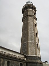
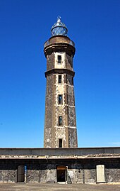
octagonal tower with balcony and lantern rising from a 2-story keeper's house
104:
91:
290:
75:
421:
46:
The iconic lighthouse at the tip of Ponta dos Capelinhos and Costa Nau
294:
282:
71:
59:
639:
Considerações sobre um plano de iluminação do arquipélago dos Açores
402:
390:
308:
674:
Guardiães do Mar dos Açores: uma viagem pelas ilhas do Atlântico
313:
The main tower of the lighthouse constructed in volcanic basalt
658:(in Portuguese), Lisbon, Portugal: Direcção de Faróis, 1955
595:
Farol da Ponta dos Capelinhos (IPA.00026312/PT072002020034)
419:), for the district of Horta, under the supervision of the
377:
By July 1903 the edifice was in a state of completion.
422:
Direcção-Geral dos Edifícios e Monumentos Nacionais
237:
229:
221:
213:
205:
197:
192:
173:
165:
157:
149:
141:
133:
125:
120:
81:
55:
559:
557:
555:
553:
551:
549:
547:
545:
543:
541:
339:What is certain, is that a Lighthouse Commission (
624:(in Portuguese). Horta: Nucleu Cultural da Horta.
169:Centro de Interpretação do Vulcão dos Capelinhos
696:Faial, Azores: Guide to the Cultural Heritage
8:
690:Daniel, Luís; Soares, Natacha, eds. (2003).
22:
526:University of North Carolina at Chapel Hill
692:Faial, Açores: Guia do Património Cultural
179:
40:
21:
723:Buildings and structures in Horta, Azores
672:Furtado, Eduardo Carvalho Vieira (2005),
508:
177:heritage without legal protection
637:Ávila, José de Almeida (15 May 1892),
587:
585:
583:
581:
579:
577:
575:
573:
571:
569:
665:Vulcão dos Capelinhos - Retrospectiva
435:Directorate for Conservation Services
7:
592:Agarez, Ricardo (2007), SIPA (ed.),
563:Fernando Faria Ribeiro (2007), p.103
427:Direcção dos Serviços de Conservação
301:volcano, which occurred in 1957–58.
255:Lighthouse of Ponta dos Capelinhos
23:Lighthouse of Ponta dos Capelinhos
14:
518:"Lighthouses of Portugal: Azores"
620:Ribeiro, Fernando Faria (2007).
474:
30:
492:List of lighthouses in Portugal
363:), and a decision to invest 15
676:(in Portuguese), p. 298,
330:Geographic Society of Portugal
209:1957 (due to volcano eruption)
1:
713:Lighthouses completed in 1903
361:Ministério das Obras Públicas
263:Farol da Ponta dos Capelinhos
663:Forjaz, Victor Hugo (1997),
417:Direcção das Obras Públicas
739:
384:
718:Lighthouses in the Azores
247:
188:
105:38.5967917°N 28.8261222°W
51:
39:
522:The Lighthouse Directory
395:Between 1957 and 1958 a
349:José de Almeida de Ávila
267:Lighthouse of Capelinhos
217:70 metres (230 ft)
110:38.5967917; -28.8261222
434:
416:
408:
400:
360:
344:
326:Sociedade de Geografia
314:
274:
262:
145:20 metres (66 ft)
16:Lighthouse in Portugal
406:
394:
312:
225:500 mm Focal Distance
647:Farol dos Capelinhos
630:Farol dos Capelinhos
275:Farol dos Capelinhos
26:Farol dos Capelinhos
293:archipelago of the
285:, on the island of
101: /
36:
409:
401:
345:Comissão de Faróis
315:
265:), or alternately
397:volcanic eruption
251:
250:
730:
699:
686:
668:
659:
650:
642:
633:
625:
607:
606:
605:
603:
589:
564:
561:
536:
535:
533:
532:
513:
484:
479:
478:
477:
351:(brother of the
184:
183:
116:
115:
113:
112:
111:
106:
102:
99:
98:
97:
94:
44:
37:
35:
34:
738:
737:
733:
732:
731:
729:
728:
727:
703:
702:
689:
684:
671:
662:
653:
645:
636:
628:
619:
611:
610:
601:
599:
591:
590:
567:
562:
539:
530:
528:
516:Rowlett, Russ.
515:
514:
510:
500:
488:
487:
482:Portugal portal
480:
475:
473:
468:
389:
383:
307:
178:
161:unpainted tower
109:
107:
103:
100:
95:
92:
90:
88:
87:
74:
70:
66:
62:
47:
28:
24:
20:
17:
12:
11:
5:
736:
734:
726:
725:
720:
715:
705:
704:
701:
700:
687:
682:
669:
660:
651:
643:
634:
626:
616:
615:
609:
608:
565:
537:
507:
506:
505:
504:
499:
496:
495:
494:
486:
485:
470:
469:
467:
464:
463:
462:
450:
449:
385:Main article:
382:
379:
365:contos de reis
353:Count of Ávila
306:
303:
249:
248:
245:
244:
241:
239:Characteristic
235:
234:
231:
227:
226:
223:
219:
218:
215:
211:
210:
207:
203:
202:
199:
195:
194:
190:
189:
186:
185:
175:
171:
170:
167:
163:
162:
159:
155:
154:
151:
147:
146:
143:
139:
138:
135:
131:
130:
127:
123:
122:
118:
117:
85:
79:
78:
57:
53:
52:
49:
48:
45:
18:
15:
13:
10:
9:
6:
4:
3:
2:
735:
724:
721:
719:
716:
714:
711:
710:
708:
697:
693:
688:
685:
683:972-9060-47-9
679:
675:
670:
666:
661:
657:
652:
648:
644:
640:
635:
631:
627:
623:
618:
617:
613:
612:
597:
596:
588:
586:
584:
582:
580:
578:
576:
574:
572:
570:
566:
560:
558:
556:
554:
552:
550:
548:
546:
544:
542:
538:
527:
523:
519:
512:
509:
502:
501:
497:
493:
490:
489:
483:
472:
465:
461:
458:
457:
456:
453:
447:
444:
443:
442:
438:
436:
432:
428:
424:
423:
418:
414:
405:
398:
393:
388:
380:
378:
375:
372:
370:
366:
362:
358:
354:
350:
346:
342:
337:
335:
331:
327:
322:
320:
311:
304:
302:
300:
296:
292:
288:
284:
280:
276:
272:
268:
264:
260:
256:
246:
242:
240:
236:
232:
228:
224:
220:
216:
212:
208:
204:
200:
196:
191:
187:
182:
176:
172:
168:
164:
160:
156:
152:
148:
144:
140:
136:
132:
128:
124:
119:
114:
96:28°49′34.04″W
93:38°35′48.45″N
86:
84:
80:
77:
73:
69:
65:
61:
58:
54:
50:
43:
38:
33:
27:
695:
691:
673:
664:
654:
646:
638:
629:
621:
600:, retrieved
594:
529:. Retrieved
521:
511:
459:
454:
451:
445:
439:
426:
425:(DGEMN) and
420:
410:
376:
373:
368:
338:
329:
325:
323:
318:
316:
279:civil parish
266:
254:
252:
214:Focal height
134:Construction
25:
602:7 September
206:Deactivated
137:stone tower
126:Constructed
108: /
83:Coordinates
707:Categories
531:2016-03-18
498:References
431:Portuguese
413:Portuguese
387:Capelinhos
381:Capelinhos
357:Portuguese
341:Portuguese
334:Ribeirinha
299:Capelinhos
291:Portuguese
271:Portuguese
259:Portuguese
19:Lighthouse
230:Intensity
198:First lit
656:Colónias
466:See also
243:Fl W 7 s
174:Heritage
166:Operator
158:Markings
76:Portugal
56:Location
614:Sources
305:History
289:in the
680:
295:Azores
283:Capelo
233:1000 W
142:Height
72:Azores
60:Capelo
694:[
503:Notes
287:Faial
193:Light
150:Shape
121:Tower
68:Faial
64:Horta
29:
678:ISBN
604:2013
253:The
222:Lens
201:1903
129:1894
281:of
709::
568:^
540:^
524:.
520:.
433::
415::
359::
343::
273::
261::
534:.
429:(
328:(
269:(
257:(
Text is available under the Creative Commons Attribution-ShareAlike License. Additional terms may apply.