42:
372:
214:
189:
and adjoining waters. Spanning an area of about 3,861,400 square kilometres (1,490,900 sq mi) and with a mean discharge of about 30,900 m/s (1,090,000 cu ft/s), the basin is almost entirely within
395:, it has a length of 2,575 kilometres (1,600 mi) and a drainage basin of 1,072,300 square kilometres (414,000 sq mi). Some significant rivers include the
754:
1381:
Stephen J. Déry et al., Characteristics and Trends of River
Discharge into Hudson, James and Ungava Bays, 1964-2000, Journal of Climate, 18 (2005), pages 2540-2557
840:
430:
of the Hudson Bay drainage basin. The rivers are presented by coastline, clockwise, starting with the George River in north-eastern Quebec, just south of
1417:
1049:
348:
911:
877:
807:
135:
708:
289:
1407:
270:
1391:
281:
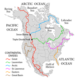
to the north. The western and northern boundary of the watershed is the Arctic Divide, and the southern and eastern boundary is the
591:
762:
1412:
359:) as being part of the Arctic Ocean, specifically "Arctic Ocean Subdivision 9.11". Other authorities include it with the
615:
274:
128:
698:
254:
55:
844:
355:) defines the Hudson Bay, with its outlet extending from 62.5 to 66.5 degrees north (just a few miles south of the
703:
654:
404:
400:
230:
207:
226:
408:
816:
626:
561:
448:
317:
958:
1004:
458:
1027:
468:
59:
935:
785:
674:
576:
502:
396:
278:
266:
258:
63:
1357:
1331:
1305:
1279:
1253:
1227:
1201:
1175:
1149:
1123:
1097:
1071:
728:
981:
907:
901:
873:
867:
507:
483:
412:
282:
195:
222:
41:
680:
646:
547:
537:
517:
497:
388:
203:
17:
542:
522:
435:
416:
371:
360:
246:
221:
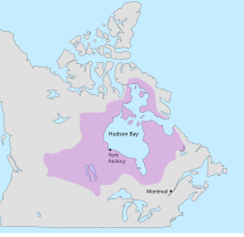
The Hudson Bay drainage basin coincides almost completely with the former territory of
199:
174:
87:
1401:
684:
571:
463:
422:
The following list of rivers includes the principal rivers draining into the Hudson,
384:
356:
250:
182:
178:
118:
662:
610:
586:
566:
532:
527:
512:
473:
431:
380:
344:
333:
329:
305:
262:
242:
217:
Rupert's Land, granted as a commercial monopoly to the Hudson's Bay
Company in 1670
51:
47:
605:
581:
478:
453:
427:
383:. While the Nelson runs a relatively short 644 kilometres (400 mi) from
321:
186:
150:
137:
423:
392:
337:
213:
841:"IHO Publication S-23 Limits of Oceans and Seas; Chapter 9: Arctic Ocean"
301:
325:
313:
309:
297:
379:
The largest river system within the Hudson Bay drainage basin is the
293:
191:
113:
370:
212:
1052:. Environment and Climate Change Canada (ECCC). 22 December 2011
391:. From the Hudson Bay to Nelson River's farthest tributary, the
843:. International Hydrographic Organization. 2002. Archived from
900:
Lewis, Edward Lyn; Jones, E. Peter; et al., eds. (2000).
387:
to the Hudson Bay, its tributaries extent as far west as the
206:. A small area of the basin is in the northern part of the
363:, in part because of its greater water budget connection.
269:. The watershed's headwaters to the south-west are on the
784:
McIntosh, Andrew; Smith, Shirlee Anne (7 February 2006).
229:
in the 17th century. It was an ideal area for the early
27:
Major drainage basin in Canada and the United States
351:(in its current unapproved working edition only of
127:
106:
98:
93:
83:
78:
70:
54:, as depicted on most atlases such as those of the
34:
46:The Hudson Bay drainage connects primarily to the
761:. Natural Resources Canada. 1985. Archived from
74:3,861,400 km (1,490,900 sq mi)
8:
872:. National Geographic Society. p. 112.
866:Earle, Sylvia A.; Glover, Linda K. (2008).
343:Hudson Bay is often considered part of the
31:
903:The Freshwater Budget of the Arctic Ocean
759:The National Atlas of Canada, 5th edition
720:
415:(1,070 km (660 mi)), and the
349:International Hydrographic Organization
7:
1362:Canadian Geographical Names Database
1336:Canadian Geographical Names Database
1310:Canadian Geographical Names Database
1284:Canadian Geographical Names Database
1258:Canadian Geographical Names Database
1232:Canadian Geographical Names Database
1206:Canadian Geographical Names Database
1180:Canadian Geographical Names Database
1154:Canadian Geographical Names Database
1128:Canadian Geographical Names Database
1102:Canadian Geographical Names Database
1076:Canadian Geographical Names Database
733:Canadian Geographical Names Database
957:Newton, Brandi (18 February 2009).
906:. Springer. pp. 101, 282–283.
709:List of rivers of the United States
241:The Hudson Bay's connection to the
290:Canadian provinces and territories
271:Continental Divide of the Americas
25:
1418:Arctic Watershed of North America
1026:Campbell, Ian (7 February 2006).
1003:Marsh, James (6 February 2006).
934:Marsh, James (7 February 2006).
40:
1394:(Website of Environment Canada)
980:Newton, Brandi (3 April 2008).
407:(1,392 km (865 mi)),
403:(1,287 km (800 mi)),
288:The basin covers parts of the
194:. It encompasses parts of the
1:
419:(740 km (460 mi)).
411:(880 km (550 mi)),
399:(550 km (340 mi)),
1124:"Rivière Qikirtaluup Kuunga"
1030:. The Canadian Encyclopedia
1007:. The Canadian Encylcopedia
984:. The Canadian Encyclopedia
961:. The Canadian Encyclopedia
938:. The Canadian Encyclopedia
869:Ocean: An Illustrated Atlas
788:. The Canadian Encyclopedia
699:Watersheds of North America
375:Nelson River drainage basin
56:National Geographic Society
1434:
1408:Hudson Bay drainage basin
1392:Water Resources of Canada
809:Limits of Oceans and Seas
353:Limits of Oceans and Seas
324:within the basin include
171:Hudson Bay drainage basin
39:
35:Hudson Bay drainage basin
18:List of Hudson Bay rivers
755:"Canada Drainage Basins"
704:List of rivers of Canada
434:and the entrance to the
231:North American fur trade
208:Midwestern United States
1364:. Government of Canada
1338:. Government of Canada
1312:. Government of Canada
1286:. Government of Canada
1260:. Government of Canada
1234:. Government of Canada
1208:. Government of Canada
1182:. Government of Canada
1156:. Government of Canada
1130:. Government of Canada
1104:. Government of Canada
1078:. Government of Canada
1050:"Hudson Bay Watershed"
815:, 1953, archived from
735:. Government of Canada
376:
218:
374:
318:Northwest Territories
237:Boundaries and limits
216:
62:and northeast of the
1413:Watersheds of Canada
959:"Saskatchewan River"
227:Hudson's Bay Company
58:, just north of the
1176:"North Knife River"
1150:"South Knife River"
1098:"Rivière Innuksuac"
347:. For example, the
147: /
60:60th parallel north
1358:"Kirchoffer River"
1005:"Assiniboine Rive"
847:on 2 February 2014
675:Southampton Island
599:Rivers of Manitoba
494:Qikirtaluup Kuunga
405:South Saskatchewan
401:North Saskatchewan
377:
277:to the south, and
275:Triple Divide Peak
267:Labrador Peninsula
259:Qikiqtaaluk Region
253:'s mouth, between
219:
64:Labrador Peninsula
1306:"Lorillard River"
1072:"Rivière Kogaluc"
913:978-0-7923-6439-9
879:978-1-4262-0319-0
822:on 8 October 2011
637:Rivers of Nunavut
555:Rivers of Ontario
283:Laurentian Divide
255:Resolution Island
225:, claimed by the
196:Canadian Prairies
185:empties into the
167:
166:
16:(Redirected from
1425:
1374:
1373:
1371:
1369:
1354:
1348:
1347:
1345:
1343:
1328:
1322:
1321:
1319:
1317:
1302:
1296:
1295:
1293:
1291:
1276:
1270:
1269:
1267:
1265:
1254:"Tha-anne River"
1250:
1244:
1243:
1241:
1239:
1228:"Geillini River"
1224:
1218:
1217:
1215:
1213:
1198:
1192:
1191:
1189:
1187:
1172:
1166:
1165:
1163:
1161:
1146:
1140:
1139:
1137:
1135:
1120:
1114:
1113:
1111:
1109:
1094:
1088:
1087:
1085:
1083:
1068:
1062:
1061:
1059:
1057:
1046:
1040:
1039:
1037:
1035:
1028:"Red Deer River"
1023:
1017:
1016:
1014:
1012:
1000:
994:
993:
991:
989:
977:
971:
970:
968:
966:
954:
948:
947:
945:
943:
931:
925:
924:
922:
920:
897:
891:
890:
888:
886:
863:
857:
856:
854:
852:
837:
831:
830:
829:
827:
821:
814:
804:
798:
797:
795:
793:
781:
775:
774:
772:
770:
751:
745:
744:
742:
740:
725:
442:Rivers of Quebec
162:
161:
159:
158:
157:
152:
148:
145:
144:
143:
140:
44:
32:
21:
1433:
1432:
1428:
1427:
1426:
1424:
1423:
1422:
1398:
1397:
1388:
1378:
1377:
1367:
1365:
1356:
1355:
1351:
1341:
1339:
1330:
1329:
1325:
1315:
1313:
1304:
1303:
1299:
1289:
1287:
1278:
1277:
1273:
1263:
1261:
1252:
1251:
1247:
1237:
1235:
1226:
1225:
1221:
1211:
1209:
1202:"Caribou River"
1200:
1199:
1195:
1185:
1183:
1174:
1173:
1169:
1159:
1157:
1148:
1147:
1143:
1133:
1131:
1122:
1121:
1117:
1107:
1105:
1096:
1095:
1091:
1081:
1079:
1070:
1069:
1065:
1055:
1053:
1048:
1047:
1043:
1033:
1031:
1025:
1024:
1020:
1010:
1008:
1002:
1001:
997:
987:
985:
979:
978:
974:
964:
962:
956:
955:
951:
941:
939:
933:
932:
928:
918:
916:
914:
899:
898:
894:
884:
882:
880:
865:
864:
860:
850:
848:
839:
838:
834:
825:
823:
819:
812:
806:
805:
801:
791:
789:
786:"Rupert's Land"
783:
782:
778:
768:
766:
765:on 4 March 2011
753:
752:
748:
738:
736:
727:
726:
722:
717:
695:
690:
634:
596:
552:
389:Rocky Mountains
369:
239:
204:Northern Canada
155:
153:
149:
146:
141:
138:
136:
134:
133:
123:
66:
28:
23:
22:
15:
12:
11:
5:
1431:
1429:
1421:
1420:
1415:
1410:
1400:
1399:
1396:
1395:
1387:
1386:External links
1384:
1383:
1382:
1376:
1375:
1349:
1323:
1297:
1280:"Wilson River"
1271:
1245:
1219:
1193:
1167:
1141:
1115:
1089:
1063:
1041:
1018:
995:
972:
949:
936:"Nelson River"
926:
912:
892:
878:
858:
832:
799:
776:
746:
719:
718:
716:
713:
712:
711:
706:
701:
694:
691:
689:
688:
678:
671:
668:
665:
660:
657:
652:
649:
644:
640:
639:
638:
633:
632:
629:
624:
621:
618:
613:
608:
602:
601:
600:
595:
594:
589:
584:
579:
574:
569:
564:
558:
557:
556:
551:
550:
545:
540:
535:
530:
525:
520:
515:
510:
505:
500:
495:
492:
489:
486:
481:
476:
471:
466:
461:
456:
451:
445:
444:
443:
436:Atlantic Ocean
368:
365:
361:Atlantic Ocean
247:Atlantic Ocean
238:
235:
200:Central Canada
175:drainage basin
165:
164:
131:
125:
124:
122:
121:
116:
110:
108:
104:
103:
100:
96:
95:
91:
90:
88:Drainage basin
85:
81:
80:
76:
75:
72:
68:
67:
50:just south of
45:
37:
36:
26:
24:
14:
13:
10:
9:
6:
4:
3:
2:
1430:
1419:
1416:
1414:
1411:
1409:
1406:
1405:
1403:
1393:
1390:
1389:
1385:
1380:
1379:
1363:
1359:
1353:
1350:
1337:
1333:
1332:"Brown River"
1327:
1324:
1311:
1307:
1301:
1298:
1285:
1281:
1275:
1272:
1259:
1255:
1249:
1246:
1233:
1229:
1223:
1220:
1207:
1203:
1197:
1194:
1181:
1177:
1171:
1168:
1155:
1151:
1145:
1142:
1129:
1125:
1119:
1116:
1103:
1099:
1093:
1090:
1077:
1073:
1067:
1064:
1051:
1045:
1042:
1029:
1022:
1019:
1006:
999:
996:
983:
976:
973:
960:
953:
950:
937:
930:
927:
915:
909:
905:
904:
896:
893:
881:
875:
871:
870:
862:
859:
846:
842:
836:
833:
818:
811:
810:
803:
800:
787:
780:
777:
764:
760:
756:
750:
747:
734:
730:
724:
721:
714:
710:
707:
705:
702:
700:
697:
696:
692:
686:
685:Baffin Island
682:
679:
676:
672:
669:
666:
664:
661:
658:
656:
653:
650:
648:
645:
642:
641:
636:
635:
630:
628:
625:
622:
619:
617:
614:
612:
609:
607:
604:
603:
598:
597:
593:
590:
588:
585:
583:
580:
578:
575:
573:
570:
568:
565:
563:
560:
559:
554:
553:
549:
546:
544:
541:
539:
536:
534:
531:
529:
526:
524:
521:
519:
516:
514:
511:
509:
506:
504:
501:
499:
496:
493:
490:
487:
485:
482:
480:
477:
475:
472:
470:
467:
465:
462:
460:
457:
455:
452:
450:
447:
446:
441:
440:
439:
437:
433:
429:
425:
420:
418:
414:
410:
406:
402:
398:
394:
390:
386:
385:Lake Winnipeg
382:
373:
366:
364:
362:
358:
357:Arctic Circle
354:
350:
346:
341:
339:
335:
331:
327:
323:
319:
315:
311:
307:
303:
299:
295:
291:
286:
284:
280:
276:
273:, bounded at
272:
268:
264:
260:
256:
252:
251:Hudson Strait
248:
244:
236:
234:
232:
228:
224:
223:Rupert's Land
215:
211:
209:
205:
201:
197:
193:
188:
184:
183:surface water
180:
179:North America
176:
172:
160:
132:
130:
126:
120:
119:United States
117:
115:
112:
111:
109:
105:
102:North America
101:
97:
92:
89:
86:
82:
77:
73:
69:
65:
61:
57:
53:
49:
43:
38:
33:
30:
19:
1366:. Retrieved
1361:
1352:
1340:. Retrieved
1335:
1326:
1314:. Retrieved
1309:
1300:
1288:. Retrieved
1283:
1274:
1262:. Retrieved
1257:
1248:
1236:. Retrieved
1231:
1222:
1210:. Retrieved
1205:
1196:
1184:. Retrieved
1179:
1170:
1158:. Retrieved
1153:
1144:
1132:. Retrieved
1127:
1118:
1106:. Retrieved
1101:
1092:
1080:. Retrieved
1075:
1066:
1054:. Retrieved
1044:
1032:. Retrieved
1021:
1009:. Retrieved
998:
986:. Retrieved
975:
963:. Retrieved
952:
940:. Retrieved
929:
917:. Retrieved
902:
895:
883:. Retrieved
868:
861:
849:. Retrieved
845:the original
835:
824:, retrieved
817:the original
808:
802:
790:. Retrieved
779:
767:. Retrieved
763:the original
758:
749:
737:. Retrieved
732:
729:"Hudson Bay"
723:
673:Kirchoffer (
577:Attawapiskat
503:Little Whale
432:Cape Chidley
421:
397:Saskatchewan
381:Nelson River
378:
352:
345:Arctic Ocean
342:
334:North Dakota
330:South Dakota
306:Saskatchewan
287:
263:Cape Chidley
249:) is at the
243:Labrador Sea
240:
220:
177:in northern
170:
168:
52:Davis Strait
48:Labrador Sea
29:
982:"Red River"
919:26 November
885:26 November
826:29 December
769:24 November
623:North Knife
620:South Knife
508:Great Whale
484:Povungnituk
428:Ungava Bays
413:Assiniboine
322:U.S. states
154: /
129:Coordinates
1402:Categories
715:References
316:, and the
187:Hudson Bay
681:Koukdjuak
667:Lorillard
647:Thlewiaza
616:Churchill
548:Harricana
538:Broadback
518:La Grande
498:Nastapoka
491:Innuksuac
393:Bow River
338:Minnesota
279:Snow Dome
151:60°N 86°W
94:Geography
1368:12 April
1342:12 April
1316:12 April
1290:12 April
1264:12 April
1238:12 April
1212:12 April
1186:12 April
1160:12 April
1134:12 April
1108:12 April
1082:12 April
1056:11 April
1034:13 April
1011:13 April
988:13 April
965:13 April
942:13 April
792:11 April
739:10 April
693:See also
655:Ferguson
651:Tha-anne
643:Geillini
543:Nottaway
523:Eastmain
417:Red Deer
302:Manitoba
99:Location
631:Caribou
572:Lawashi
488:Kogaluc
464:Koksoak
326:Montana
314:Nunavut
310:Alberta
298:Ontario
265:on the
257:in the
173:is the
163:
156:60; -86
107:Country
79:Geology
910:
876:
851:1 July
663:Thelon
659:Wilson
611:Nelson
592:Severn
587:Winisk
567:Albany
533:Rupert
528:Pontax
513:Roggan
474:Arnaud
449:George
426:, and
367:Rivers
336:, and
308:, and
294:Quebec
202:, and
192:Canada
181:where
114:Canada
820:(PDF)
813:(PDF)
670:Brown
606:Hayes
582:Ekwan
562:Moose
479:Kovik
459:False
454:Whale
424:James
245:(the
1370:2024
1344:2024
1318:2024
1292:2024
1266:2024
1240:2024
1214:2024
1188:2024
1162:2024
1136:2024
1110:2024
1084:2024
1058:2024
1036:2024
1013:2024
990:2024
967:2024
944:2024
921:2010
908:ISBN
887:2010
874:ISBN
853:2017
828:2020
794:2024
771:2010
741:2024
627:Seal
469:Leaf
261:and
169:The
142:86°W
139:60°N
84:Type
71:Area
409:Red
292:of
1404::
1360:.
1334:.
1308:.
1282:.
1256:.
1230:.
1204:.
1178:.
1152:.
1126:.
1100:.
1074:.
757:.
731:.
438:.
340:.
332:,
328:,
320:.
312:,
304:,
300:,
296:,
285:.
233:.
210:.
198:,
1372:.
1346:.
1320:.
1294:.
1268:.
1242:.
1216:.
1190:.
1164:.
1138:.
1112:.
1086:.
1060:.
1038:.
1015:.
992:.
969:.
946:.
923:.
889:.
855:.
796:.
773:.
743:.
687:)
683:(
677:)
20:)
Text is available under the Creative Commons Attribution-ShareAlike License. Additional terms may apply.