752:
469:
1109:
22:
266:
338:
684:
130:
612:
198:
52:. The locations of the historical markers and their latitude and longitude coordinates are included below when available, along with their names, years of placement, and topics as recorded by the Historical Bureau. There are 10 historical markers located in Montgomery County.
825:
560:
214:
632:
988:
768:
489:
286:
354:
1458:
700:
417:
146:
1047:
462:
1226:
1201:
1206:
60:
1211:
1236:
1216:
49:
1241:
1231:
1221:
1196:
1191:
1453:
1385:
1040:
820:
87:
82:
1359:
468:
77:
1344:
605:
751:
1033:
1025:
72:
265:
21:
1057:
534:
259:
37:
963:
1319:
331:
1324:
1251:
1098:
1079:
761:
693:
625:
482:
410:
207:
139:
1423:
1309:
1314:
1259:
1153:
745:
549:
1430:
1400:
1395:
1374:
1369:
1364:
1349:
279:
1380:
1279:
1148:
1133:
347:
123:
1334:
1299:
1264:
1168:
553:
399:
1339:
1294:
1163:
1158:
1120:
1354:
1329:
1173:
346:
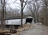
County Roads 500N and 600E at the southwestern corner of this bridge over Sugar Creek, near
337:
1390:
1304:
1143:
1138:
36:
This is intended to be a complete list of the official state historical markers placed in
1183:
1128:
621:
545:
478:
275:
1447:
1289:
1269:
677:
45:
683:
129:
1072:
191:
611:
845:
784:
770:
716:
702:
648:
634:
576:
562:
505:
491:
433:
419:
370:
356:
302:
288:
230:
216:
162:
148:
949:
937:
925:
913:
901:
889:
877:
865:
826:
National
Register of Historic Places listings in Montgomery County, Indiana
197:
1414:‡This populated place also has portions in an adjacent county or counties
1015:
41:
1020:
1108:
326:
American Indian/Native
American, Early Settlement and Exploration
20:
1090:
620:
Carnegie Museum of
Montgomery County, 222 S. Washington Street (
1029:
672:
Education & Libraries, Buildings & Architecture, Women
1107:
278:
and County Road 1150S, adjacent to
Parkersburg Spring near
952:, Indiana Historical Bureau, n.d. Accessed 2012-03-14.
940:, Indiana Historical Bureau, n.d. Accessed 2012-03-14.
928:, Indiana Historical Bureau, n.d. Accessed 2012-03-14.
916:, Indiana Historical Bureau, n.d. Accessed 2012-03-14.
904:, Indiana Historical Bureau, n.d. Accessed 2012-03-14.
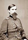
892:, Indiana Historical Bureau, n.d. Accessed 2012-03-14.
880:, Indiana Historical Bureau, n.d. Accessed 2012-03-14.
868:, Indiana Historical Bureau, n.d. Accessed 2012-03-14.
760:
Northwest corner of S. Grant Ave. and W. Wabash Ave.,
457:
Underground
Railroad; African American; Black History
31:
Indiana state historical markers in
Montgomery County
529:
1409:
1278:
1250:
1182:
1119:
1089:
938:William Bratton, Lewis and Clark Expedition Member
588:William Bratton, Lewis and Clark Expedition Member
535:William Bratton, Lewis and Clark Expedition Member
206:501 Pike Street at the Wallace Avenue junction in
1459:Tourist attractions in Montgomery County, Indiana
552:at Old Pioneer Cemetery on the eastern edge of
1112:Map of Indiana highlighting Montgomery County
1041:
477:Old Jail Museum at 225 N. Washington Street (
8:
600:Early Settlement and Exploration, Cemetery
394:Transportation, Buildings and Architecture
1048:
1034:
1026:
808:Science, Medicine, & Invention; Women
750:
682:
102:
821:List of Indiana state historical markers
138:212 S. Water Street at Wabash Avenue in
25:Location of Montgomery County in Indiana
837:
108:
846:"Indiana Historical Markers by County"
186:Politics, Buildings and Architecture
7:
989:"Dr Mary Holloway Wilhite 1831-1892"
878:Major General Lew Wallace 1827-1905
746:Dr Mary Holloway Wilhite, 1831-1892
481:) by the Spring Street junction in
242:Major General Lew Wallace 1827-1905
192:Major General Lew Wallace 1827-1905
1056:Municipalities and communities of
14:
1016:Indiana Historical Marker Program
950:Crawfordsville’s Carnegie Library
660:Crawfordsville's Carnegie Library
606:Crawfordsville's Carnegie Library
1454:Indiana state historical markers
610:
544:Eastern side of the junction of
467:
336:
264:
196:
128:
1:
926:Montgomery County Rotary Jail
517:Montgomery County Rotary Jail
463:Montgomery County Rotary Jail
254:Military, Arts and Culture
88:GPX (secondary coordinates)
1475:
1059:Montgomery County, Indiana
1419:
1105:
1070:
1021:Indiana Historical Bureau
902:Darlington Covered Bridge
890:Chief Cornstalk's Village
382:Darlington Covered Bridge
332:Darlington Covered Bridge
314:Chief Cornstalk's Village
260:Chief Cornstalk's Village
83:GPX (primary coordinates)
58:Map all coordinates using
50:Indiana Historical Bureau
796:Dr Mary Holloway Wilhite
66:Download coordinates as:
785:40.039639°N 86.904361°W
1113:
434:40.044778°N 86.90417°W
231:40.040722°N 86.89528°W
29:This is a list of the
26:
1111:
790:40.039639; -86.904361
717:40.03944°N 86.89806°W
649:40.03972°N 86.90111°W
577:40.08778°N 87.05917°W
506:40.04389°N 86.90167°W
371:40.10750°N 86.79361°W
303:39.87306°N 86.90306°W
163:40.04000°N 86.89750°W
78:GPX (all coordinates)
24:
1432:United States portal
439:40.044778; -86.90417
409:310 N. Grant St. in
236:40.040722; -86.89528
780: /
722:40.03944; -86.89806
712: /
654:40.03972; -86.90111
644: /
582:40.08778; -87.05917
572: /
511:40.04389; -86.90167
501: /
429: /
376:40.10750; -86.79361
366: /
308:39.87306; -86.90306
298: /
226: /
168:40.04000; -86.89750
158: /
1114:
987:IHB (2020-12-16).
962:IHB (2020-12-15).
848:. State of Indiana
99:Historical markers
27:
1441:
1440:
812:
811:
805:
737:
692:212 S. Water St.
669:
597:
526:
454:
391:
323:
251:
183:
38:Montgomery County
1466:
1433:
1426:
1320:Darlington Woods
1110:
1082:
1075:
1065:
1060:
1050:
1043:
1036:
1027:
1003:
1002:
1000:
999:
984:
978:
977:
975:
974:
959:
953:
947:
941:
935:
929:
923:
917:
911:
905:
899:
893:
887:
881:
875:
869:
863:
857:
856:
854:
853:
842:
804:
803:
801:
800:
799:
797:
792:
791:
786:
781:
778:
777:
776:
773:
765:
754:
736:
735:
733:
732:
731:
729:
724:
723:
718:
713:
710:
709:
708:
705:
697:
686:
668:
667:
665:
664:
663:
661:
656:
655:
650:
645:
642:
641:
640:
637:
629:
614:
596:
595:
593:
592:
591:
589:
584:
583:
578:
573:
570:
569:
568:
565:
557:
525:
524:
522:
521:
520:
518:
513:
512:
507:
502:
499:
498:
497:
494:
486:
471:
453:
452:
450:
449:
448:
446:
441:
440:
435:
430:
427:
426:
425:
422:
414:
390:
389:
387:
386:
385:
383:
378:
377:
372:
367:
364:
363:
362:
359:
351:
340:
322:
321:
319:
318:
317:
315:
310:
309:
304:
299:
296:
295:
294:
291:
283:
268:
250:
249:
247:
246:
245:
243:
238:
237:
232:
227:
224:
223:
222:
219:
211:
200:
182:
181:
179:
178:
177:
175:
170:
169:
164:
159:
156:
155:
154:
151:
143:
132:
103:
1474:
1473:
1469:
1468:
1467:
1465:
1464:
1463:
1444:
1443:
1442:
1437:
1431:
1424:
1415:
1405:
1281:
1274:
1246:
1178:
1115:
1103:
1085:
1080:
1073:
1066:
1063:
1058:
1054:
1012:
1007:
1006:
997:
995:
986:
985:
981:
972:
970:
961:
960:
956:
948:
944:
936:
932:
924:
920:
912:
908:
900:
896:
888:
884:
876:
872:
864:
860:
851:
849:
844:
843:
839:
834:
817:
795:
793:
789:
787:
783:
782:
779:
774:
771:
769:
767:
766:
764:
727:
725:
721:
719:
715:
714:
711:
706:
703:
701:
699:
698:
696:
659:
657:
653:
651:
647:
646:
643:
638:
635:
633:
631:
630:
628:
587:
585:
581:
579:
575:
574:
571:
566:
563:
561:
559:
558:
556:
516:
514:
510:
508:
504:
503:
500:
495:
492:
490:
488:
487:
485:
444:
442:
438:
436:
432:
431:
428:
423:
420:
418:
416:
415:
413:
381:
379:
375:
373:
369:
368:
365:
360:
357:
355:
353:
352:
350:
313:
311:
307:
305:
301:
300:
297:
292:
289:
287:
285:
284:
282:
241:
239:
235:
233:
229:
228:
225:
220:
217:
215:
213:
212:
210:
173:
171:
167:
165:
161:
160:
157:
152:
149:
147:
145:
144:
142:
101:
96:
95:
94:
93:
92:
18:
12:
11:
5:
1472:
1470:
1462:
1461:
1456:
1446:
1445:
1439:
1438:
1436:
1435:
1428:
1425:Indiana portal
1420:
1417:
1416:
1413:
1411:
1407:
1406:
1404:
1403:
1398:
1393:
1388:
1383:
1378:
1372:
1367:
1362:
1357:
1352:
1347:
1342:
1337:
1332:
1327:
1322:
1317:
1312:
1307:
1302:
1297:
1292:
1286:
1284:
1276:
1275:
1273:
1272:
1267:
1262:
1256:
1254:
1248:
1247:
1245:
1244:
1239:
1234:
1229:
1224:
1219:
1214:
1209:
1204:
1199:
1194:
1188:
1186:
1180:
1179:
1177:
1176:
1171:
1166:
1161:
1156:
1151:
1146:
1141:
1136:
1131:
1125:
1123:
1117:
1116:
1106:
1104:
1102:
1101:
1099:Crawfordsville
1095:
1093:
1087:
1086:
1081:Crawfordsville
1071:
1068:
1067:
1055:
1053:
1052:
1045:
1038:
1030:
1024:
1023:
1018:
1011:
1010:External links
1008:
1005:
1004:
979:
964:"Henry S Lane"
954:
942:
930:
918:
906:
894:
882:
870:
858:
836:
835:
833:
830:
829:
828:
823:
816:
813:
810:
809:
806:
762:Crawfordsville
758:
755:
748:
742:
741:
738:
694:Crawfordsville
690:
687:
680:
674:
673:
670:
626:Crawfordsville
622:U.S. Route 231
618:
615:
608:
602:
601:
598:
546:U.S. Route 136
542:
539:
537:
531:
530:
527:
483:Crawfordsville
479:U.S. Route 231
475:
472:
465:
459:
458:
455:
411:Crawfordsville
407:
404:
402:
396:
395:
392:
344:
341:
334:
328:
327:
324:
276:U.S. Route 231
272:
269:
262:
256:
255:
252:
208:Crawfordsville
204:
201:
194:
188:
187:
184:
140:Crawfordsville
136:
133:
126:
120:
119:
116:
113:
110:
107:
100:
97:
91:
90:
85:
80:
75:
69:
63:
56:
55:
54:
13:
10:
9:
6:
4:
3:
2:
1471:
1460:
1457:
1455:
1452:
1451:
1449:
1434:
1429:
1427:
1422:
1421:
1418:
1412:
1408:
1402:
1399:
1397:
1394:
1392:
1389:
1387:
1386:Taylor Corner
1384:
1382:
1379:
1376:
1373:
1371:
1368:
1366:
1363:
1361:
1358:
1356:
1353:
1351:
1348:
1346:
1343:
1341:
1338:
1336:
1333:
1331:
1328:
1326:
1323:
1321:
1318:
1316:
1313:
1311:
1310:Browns Valley
1308:
1306:
1303:
1301:
1298:
1296:
1293:
1291:
1288:
1287:
1285:
1283:
1277:
1271:
1268:
1266:
1263:
1261:
1258:
1257:
1255:
1253:
1249:
1243:
1240:
1238:
1235:
1233:
1230:
1228:
1225:
1223:
1220:
1218:
1215:
1213:
1210:
1208:
1205:
1203:
1200:
1198:
1195:
1193:
1190:
1189:
1187:
1185:
1181:
1175:
1172:
1170:
1167:
1165:
1162:
1160:
1157:
1155:
1152:
1150:
1147:
1145:
1142:
1140:
1137:
1135:
1132:
1130:
1127:
1126:
1124:
1122:
1118:
1100:
1097:
1096:
1094:
1092:
1088:
1084:
1083:
1076:
1069:
1064:United States
1061:
1051:
1046:
1044:
1039:
1037:
1032:
1031:
1028:
1022:
1019:
1017:
1014:
1013:
1009:
994:
990:
983:
980:
969:
965:
958:
955:
951:
946:
943:
939:
934:
931:
927:
922:
919:
915:
910:
907:
903:
898:
895:
891:
886:
883:
879:
874:
871:
867:
862:
859:
847:
841:
838:
831:
827:
824:
822:
819:
818:
814:
807:
802:
763:
759:
756:
753:
749:
747:
744:
743:
739:
734:
728:Henry S. Lane
695:
691:
688:
685:
681:
679:
678:Henry S. Lane
676:
675:
671:
666:
627:
623:
619:
616:
613:
609:
607:
604:
603:
599:
594:
555:
551:
550:State Road 25
547:
543:
540:
538:
536:
533:
532:
528:
523:
484:
480:
476:
473:
470:
466:
464:
461:
460:
456:
451:
412:
408:
405:
403:
401:
398:
397:
393:
388:
349:
345:
342:
339:
335:
333:
330:
329:
325:
320:
281:
277:
273:
270:
267:
263:
261:
258:
257:
253:
248:
209:
205:
202:
199:
195:
193:
190:
189:
185:
180:
141:
137:
134:
131:
127:
125:
122:
121:
117:
114:
111:
106:Marker title
105:
104:
98:
89:
86:
84:
81:
79:
76:
74:
71:
70:
68:
67:
62:
61:OpenStreetMap
59:
53:
51:
47:
46:United States
43:
39:
34:
32:
23:
19:
16:
1315:Cherry Grove
1260:Lake Holiday
1154:New Richmond
1078:
996:. Retrieved
992:
982:
971:. Retrieved
967:
957:
945:
933:
921:
909:
897:
885:
873:
861:
850:. Retrieved
840:
775:86°54′15.7″W
772:40°02′22.7″N
274:Junction of
112:Year placed
65:
64:
57:
35:
30:
28:
17:
15:
1401:Yountsville
1396:Whitesville
1375:Shannondale
1370:Parkersburg
1365:North Union
1350:Kirkpatrick
1325:Deer's Mill
1282:communities
1227:Sugar Creek
1074:County seat
914:Speed Cabin
788: /
720: /
652: /
580: /
509: /
445:Speed Cabin
437: /
421:40°2′41.2″N
400:Speed Cabin
374: /
306: /
280:Parkersburg
234: /
218:40°2′26.6″N
166: /
1448:Categories
1381:Smartsburg
1360:Manchester
1202:Coal Creek
1149:New Market
1134:Darlington
998:2024-03-18
973:2024-03-18
866:Lane Place
852:2012-03-15
832:References
794: (
726: (
707:86°53′53″W
704:40°02′22″N
658: (
636:40°02′23″N
586: (
515: (
443: (
424:86°54′15″W
380: (
361:86°47′37″W
348:Darlington
312: (
293:86°54′11″W
290:39°52′23″N
240: (
221:86°53′43″W
174:Lane Place
172: (
153:86°53′51″W
124:Lane Place
1410:Footnotes
1335:Fiskville
1300:Beckville
1265:Linnsburg
1184:Townships
1169:Waynetown
740:Politics
639:86°54′4″W
567:87°3′33″W
564:40°5′16″N
554:Waynetown
496:86°54′6″W
493:40°2′38″N
358:40°6′27″N
150:40°2′24″N
115:Location
1345:Hibernia
1340:Garfield
1295:Balhinch
1207:Franklin
1164:Waveland
1159:New Ross
815:See also
1355:Lapland
1330:Elmdale
1212:Madison
1174:Wingate
118:Topics
48:by the
42:Indiana
1391:Wesley
1305:Bowers
1237:Walnut
1217:Ripley
1144:Linden
1139:Ladoga
109:Image
1280:Other
1242:Wayne
1232:Union
1222:Scott
1197:Clark
1192:Brown
1129:Alamo
1121:Towns
757:2020
689:2012
624:) in
617:2009
541:2002
474:2000
406:1995
343:1993
271:1981
203:1963
135:1962
1290:Ames
1270:Mace
1252:CDPs
1091:City
548:and
993:IHB
968:IHB
73:KML
1450::
1077::
1062:,
991:.
966:.
44:,
40:,
33:.
1377:‡
1049:e
1042:t
1035:v
1001:.
976:.
855:.
798:)
730:)
662:)
590:)
519:)
447:)
384:)
316:)
244:)
176:)
Text is available under the Creative Commons Attribution-ShareAlike License. Additional terms may apply.