Name on the Register
Image
Date listed
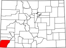
Location
City or town
Description
1
Albert Porter Pueblo Upload image March 18, 1999 (#99000266 ) Address Restricted Yellow Jacket
2
Anasazi Archeological District Upload image July 19, 1984 (#84001273 ) Address Restricted Dolores
3
Archeological Site no. 5MT4700 Upload image June 11, 1999 (#99000685 ) Address Restricted Yellow Jacket
4
Bass Site Upload image June 11, 1999 (#99000654 ) Address Restricted Yellow Jacket
5
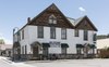
Bauer Bank Block Bauer Bank Block October 11, 2003 (#03001009 ) 107 W. Grand Ave. 37°20′42″N 108°17′20″W / 37.345°N 108.288889°W / 37.345; -108.288889 (Bauer Bank Block ) Mancos
6
Cannonball Ruins Cannonball Ruins April 30, 1997 (#97000378 ) Address Restricted Cortez
7
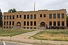
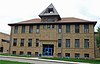
Cortez High School Cortez High School March 22, 2016 (#16000098 ) 121 E. First St. 37°20′50″N 108°34′59″W / 37.347166°N 108.583126°W / 37.347166; -108.583126 (Cortez High School ) Cortez Cortez' old high school, most recently Calkins Jr. High School.
8
Ertel Funeral Home Ertel Funeral Home November 7, 1995 (#95001248 ) 42 N. Market St. 37°20′58″N 108°35′03″W / 37.349444°N 108.584167°W / 37.349444; -108.584167 (Ertel Funeral Home ) Cortez
9
Escalante Ruin Escalante Ruin November 20, 1975 (#75000527 ) Address Restricted 37°28′40″N 108°32′44″W / 37.477766°N 108.545668°W / 37.477766; -108.545668 (Escalante Ruin ) Dolores
10
Exon & Rush Meat Market and Mercantile Upload image April 22, 2024 (#100009564 ) 315 Central Ave. 37°28′26″N 108°30′17″W / 37.4739°N 108.5048°W / 37.4739; -108.5048 (Exon & Rush Meat Market and Mercantile ) Dolores
11
Haynie Site Upload image November 13, 2017 (#100001792 ) 29619 Cty. Rd. L 37°22′41″N 108°30′15″W / 37.378181°N 108.504202°W / 37.378181; -108.504202 (Haynie Site ) Mancos vicinity
12
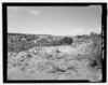
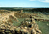
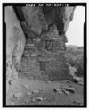
Hovenweep National Monument Hovenweep National Monument October 15, 1966 (#66000250 ) Northwest of Cortez 37°26′35″N 108°58′56″W / 37.443056°N 108.982222°W / 37.443056; -108.982222 (Hovenweep National Monument ) Cortez
13
Indian Camp Ranch Archeological District Upload image March 28, 2012 (#12000145 ) Address Restricted Cortez vicinity
14
Joe Ben Wheat Site Complex Upload image January 16, 2004 (#03001383 ) Address Restricted Yellow Jacket
15
James A. Lancaster Site Upload image April 14, 1980 (#80000914 ) Address Restricted Pleasant View
16
Lebanon School Lebanon School May 29, 1996 (#96000543 ) 24925 County Road T 37°27′28″N 108°35′29″W / 37.457778°N 108.591389°W / 37.457778; -108.591389 (Lebanon School ) Dolores
17
Lost Canyon Archeological District Upload image October 18, 1988 (#88001909 ) Address Restricted Mancos
18
Lowry Ruin Lowry Ruin October 15, 1966 (#66000253 ) 30 miles (48 km) northwest of Cortez via U.S. Route 160 37°35′04″N 108°55′11″W / 37.584531°N 108.919647°W / 37.584531; -108.919647 (Lowry Ruin ) Pleasant View
19
Mancos High School Mancos High School December 23, 1991 (#91001740 ) 350 Grand Ave. 37°20′44″N 108°17′32″W / 37.345556°N 108.292222°W / 37.345556; -108.292222 (Mancos High School ) Mancos
20
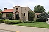
Mancos Opera House Mancos Opera House January 7, 1988 (#87002183 ) 136 W. Grand Ave. 37°20′11″N 108°17′23″W / 37.336389°N 108.289722°W / 37.336389; -108.289722 (Mancos Opera House ) Mancos
21
Mesa Verde Administrative District Mesa Verde Administrative District May 28, 1987 (#87001410 ) Area at head of Spruce Canyon off park service road 37°11′03″N 108°29′18″W / 37.184221°N 108.488378°W / 37.184221; -108.488378 (Mesa Verde Administrative District ) Mesa Verde National Park
22
Mesa Verde National Park Mesa Verde National Park October 15, 1966 (#66000251 ) 10 miles (16 km) east of Cortez on U.S. Route 160 37°14′52″N 108°27′06″W / 37.247821°N 108.451595°W / 37.247821; -108.451595 (Mesa Verde National Park ) Cortez
23
Mitchell Springs Archeological Site Upload image November 9, 2001 (#01001207 ) 7755 Road 25 37°19′30″N 108°35′44″W / 37.324893°N 108.595553°W / 37.324893; -108.595553 (Mitchell Springs Archeological Site ) Cortez
24
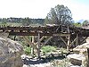
Montezuma Valley Irrigation Company Flume No. 6 Montezuma Valley Irrigation Company Flume No. 6 March 27, 2012 (#12000146 ) Approximately 4 miles (6.4 km) east of Cortez on US 160 37°20′52″N 108°30′10″W / 37.347896°N 108.502647°W / 37.347896; -108.502647 (Montezuma Valley Irrigation Company Flume No. 6 ) Cortez vicinity
25
Montezuma Valley National Bank and Store Building Montezuma Valley National Bank and Store Building January 15, 2009 (#08001317 ) 2-8 Main St. 37°20′55″N 108°35′06″W / 37.34864°N 108.58502°W / 37.34864; -108.58502 (Montezuma Valley National Bank and Store Building ) Cortez
26
Mud Springs Pueblo Upload image October 29, 1982 (#82001020 ) Address Restricted Cortez
27
Painted Hand Pueblo Upload image May 8, 2014 (#13000576 ) Address Restricted Pleasant View
28
Pigge Site Upload image April 7, 1980 (#80000915 ) Address Restricted Pleasant View
29
Roy's Ruin Upload image January 31, 1992 (#91002027 ) Address Restricted Cortez
30
Sand Canyon Archaeological District Sand Canyon Archaeological District March 15, 2005 (#05000138 ) Address Restricted Cortez
31
Seven Towers Pueblo Upload image June 11, 1999 (#99000653 ) Address Restricted Yellow Jacket
32
Southern Hotel Southern Hotel February 23, 1989 (#89000018 ) 101 S. 5th St. 37°28′35″N 108°30′09″W / 37.476389°N 108.5025°W / 37.476389; -108.5025 (Southern Hotel ) Dolores
33
Ute Mountain Ute Mancos Canyon Historic District Ute Mountain Ute Mancos Canyon Historic District May 2, 1972 (#72000273 ) Address Restricted Durango
34
Woods Canyon Pueblo Upload image June 11, 1999 (#99000652 ) Address Restricted Yellow Jacket
35
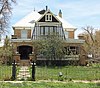
Wrightsman House Wrightsman House February 14, 1997 (#97000045 ) 209 Bauer Ave. 37°20′45″N 108°17′25″W / 37.345833°N 108.290278°W / 37.345833; -108.290278 (Wrightsman House ) Mancos
36
Yellowjacket Pueblo (5-MT-5) Upload image September 28, 1985 (#85002701 ) Address Restricted Yellow Jacket
37
Yucca House National Monument Yucca House National Monument October 15, 1966 (#66000252 ) 12 miles (19 km) south of Cortez via U.S. Route 666 37°15′00″N 108°41′07″W / 37.25°N 108.685278°W / 37.25; -108.685278 (Yucca House National Monument ) Cortez