This is a list of properties and historic districts in Tennessee that are listed on the National Register of Historic Places. There are over 2,000 in total. Of these, 29 are National Historic Landmarks. Each of Tennessee's 95 counties has at least one listing.
The Tennessee Historical Commission, which manages the state's participation in the National Register program, reports that 80 percent of the state's area has been surveyed for historic buildings. Surveys for archaeological sites have been less extensive; coverage is estimated less than 5 percent of the state. Not all properties that have been determined to be eligible for National Register are listed.
The locations of National Register properties and districts (at least for all showing latitude and longitude coordinates below), may be seen in an online map by clicking on "Map of all coordinates".
Download coordinates as:
| Anderson – Bedford – Benton – Bledsoe – Blount – Bradley – Campbell – Cannon – Carroll – Carter – Cheatham – Chester – Claiborne – Clay – Cocke – Coffee – Crockett – Cumberland – Davidson – Decatur – DeKalb – Dickson – Dyer – Fayette – Fentress – Franklin – Gibson – Giles – Grainger – Greene – Grundy – Hamblen – Hamilton – Hancock – Hardeman – Hardin – Hawkins – Haywood – Henderson – Henry – Hickman – Houston – Humphreys – Jackson – Jefferson – Johnson – Knox – Lake – Lauderdale – Lawrence – Lewis – Lincoln – Loudon – Macon – Madison – Marion – Marshall – Maury – McMinn – McNairy – Meigs – Monroe – Montgomery – Moore – Morgan – Obion – Overton – Perry – Pickett – Polk – Putnam – Rhea – Roane – Robertson – Rutherford – Scott – Sequatchie – Sevier – Shelby – Smith – Stewart – Sullivan – Sumner – Tipton – Trousdale – Unicoi – Union – Van Buren – Warren – Washington – Wayne – Weakley – White – Williamson – Wilson |
This National Park Service list is complete through NPS recent listings posted September 20, 2024.
Current listings by county
The following are approximate tallies of current listings by county. These counts are based on entries in the National Register Information Database as of April 24, 2008 and new weekly listings posted since then on the National Register of Historic Places web site. There are frequent additions to the listings and occasional delistings and the counts here are approximate and not official. New entries are added to the official Register on a weekly basis. Also, the counts in this table exclude boundary increase and decrease listings which only modify the area covered by an existing property or district, although carrying a separate National Register reference number.
The Tennessee county with the largest number of National Register listings is Davidson County, site of the state capital, Nashville.

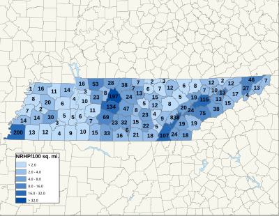
| County | # of Sites | |
|---|---|---|
| 1 | Anderson | 20 |
| 2 | Bedford | 32 |
| 3 | Benton | 3 |
| 4 | Bledsoe | 9 |
| 5 | Blount | 74 |
| 6 | Bradley | 24 |
| 7 | Campbell | 8 |
| 8 | Cannon | 10 |
| 9 | Carroll | 6 |
| 10 | Carter | 13 |
| 11 | Cheatham | 8 |
| 12 | Chester | 3 |
| 13 | Claiborne | 12 |
| 14 | Clay | 2 |
| 15 | Cocke | 15 |
| 16 | Coffee | 16 |
| 17 | Crockett | 2 |
| 18 | Cumberland | 8 |
| 19 | Davidson | 199 |
| 20 | Decatur | 5 |
| 21 | DeKalb | 5 |
| 22 | Dickson | 23 |
| 23 | Dyer | 9 |
| 24 | Fayette | 13 |
| 25 | Fentress | 12 |
| 26 | Franklin | 22 |
| 27 | Gibson | 20 |
| 28 | Giles | 33 |
| 29 | Grainger | 9 |
| 30 | Greene | 17 |
| 31 | Grundy | 22 |
| 32 | Hamblen | 13 |
| 33 | Hamilton | 108 |
| 34 | Hancock | 2 |
| 35 | Hardeman | 12 |
| 36 | Hardin | 9 |
| 37 | Hawkins | 12 |
| 38 | Haywood | 16 |
| 39 | Henderson | 5 |
| 40 | Henry | 15 |
| 41 | Hickman | 11 |
| 42 | Houston | 3 |
| 43 | Humphreys | 10 |
| 44 | Jackson | 6 |
| 45 | Jefferson | 13 |
| 46 | Johnson | 7 |
| 47 | Knox | 116 |
| 48 | Lake | 1 |
| 49 | Lauderdale | 7 |
| 50 | Lawrence | 15 |
| 51 | Lewis | 7 |
| 52 | Lincoln | 17 |
| 53 | Loudon | 24 |
| 54 | Macon | 7 |
| 55 | Madison | 30 |
| 56 | Marion | 18 |
| 57 | Marshall | 23 |
| 58 | Maury | 69 |
| 59 | McMinn | 19 |
| 60 | McNairy | 4 |
| 61 | Meigs | 37 |
| 62 | Monroe | 20 |
| 63 | Montgomery | 53 |
| 64 | Moore | 6 |
| 65 | Morgan | 5 |
| 66 | Obion | 16 |
| 67 | Overton | 7 |
| 68 | Perry | 6 |
| 69 | Pickett | 3 |
| 70 | Polk | 18 |
| 71 | Putnam | 15 |
| 72 | Rhea | 8 |
| 73 | Roane | 20 |
| 74 | Robertson | 28 |
| 75 | Rutherford | 48 |
| 76 | Scott | 6 |
| 77 | Sequatchie | 5 |
| 78 | Sevier | 37 |
| 79 | Shelby | 203 |
| 80 | Smith | 13 |
| 81 | Stewart | 16 |
| 82 | Sullivan | 46 |
| 83 | Sumner | 39 |
| 84 | Tipton | 14 |
| 85 | Trousdale | 7 |
| 86 | Unicoi | 4 |
| 87 | Union | 7 |
| 88 | Van Buren | 4 |
| 89 | Warren | 23 |
| 90 | Washington | 37 |
| 91 | Wayne | 10 |
| 92 | Weakley | 12 |
| 93 | White | 12 |
| 94 | Williamson | 133 |
| 95 | Wilson | 24 |
| (duplicates) | (23) | |
| Total: | 2,172 | |
| Name on the Register | Image | Date listed | Location | City or town | Description | |
|---|---|---|---|---|---|---|
| 1 | Reynoldsburg-Paris Road | Upload image | August 7, 2005 (#05000803) |
5.0 miles northeast of Camden off Chestnut Hill Rd. 36°06′00″N 87°58′36″W / 36.1°N 87.976667°W / 36.1; -87.976667 (Reynoldsburg-Paris Road) | Camden | A Trail of Tears site |
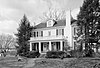
| 2 | William Thompson House | 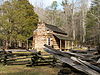 |
May 6, 1976 (#76001763) |
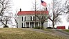
South of Camden, off State Route 69 36°02′24″N 88°05′37″W / 36.04°N 88.093611°W / 36.04; -88.093611 (William Thompson House) | Camden | |
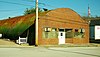
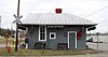
| 3 | US Post Office |  |
September 23, 1988 (#88001577) |
81 N. Forest St. 36°03′30″N 88°05′49″W / 36.058333°N 88.096944°W / 36.058333; -88.096944 (US Post Office) | Camden |
Former listings
| Name on the Register | Image | Date listed | Date removed | Location | City or town | Description | |
|---|---|---|---|---|---|---|---|
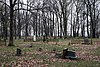
| 1 | Mount Zion Church | Upload image | October 2, 1973 (#73001752) | July 17, 2012 | 5.5 miles southeast of Big Sandy 36°10′41″N 88°01′10″W / 36.178056°N 88.019444°W / 36.178056; -88.019444 (Mount Zion Church) | Big Sandy | Destroyed by arsonist. |
| 2 | John Rushing Farm | Upload image | December 17, 1999 (#99001587) | June 10, 2022 | 5760 N. State Route 69A 36°08′00″N 88°06′15″W / 36.133333°N 88.104167°W / 36.133333; -88.104167 (John Rushing Farm) | Camden |


Former listing
| Name on the Register | Image | Date listed | Date removed | Location | City or town | Description | |
|---|---|---|---|---|---|---|---|
| 1 | Hillsman House | Upload image | March 25, 1982 (#82003955) | June 10, 2022 | Old Hinkledale-McKenzie Rd. 36°02′23″N 88°36′44″W / 36.039722°N 88.612222°W / 36.039722; -88.612222 (Hillsman House) | Trezevant |


| Name on the Register | Image | Date listed | Location | City or town | Description | |
|---|---|---|---|---|---|---|
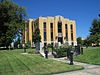
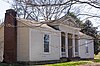
| 1 | Chester County Courthouse |  |
March 26, 1979 (#79002418) |
Court Sq. 35°26′24″N 88°38′27″W / 35.44°N 88.640833°W / 35.44; -88.640833 (Chester County Courthouse) | Henderson | |
| 2 | Hamlett-Smith House |  |
December 1, 1983 (#83004227) |
Jacks Creek-Mifflin Rd. 35°29′20″N 88°31′17″W / 35.488889°N 88.521389°W / 35.488889; -88.521389 (Hamlett-Smith House) | Jacks Creek | |
| 3 | National Teacher's Normal and Business College Administration Building | 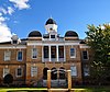 |
March 12, 2012 (#12000116) |
158 E. Main St. 35°26′25″N 88°38′22″W / 35.440278°N 88.639444°W / 35.440278; -88.639444 (National Teacher's Normal and Business College Administration Building) | Henderson |
| Name on the Register | Image | Date listed | Location | City or town | Description | |
|---|---|---|---|---|---|---|
| 1 | Clay County Courthouse |  |
September 22, 1977 (#77001261) |
State Route 52 36°33′02″N 85°30′22″W / 36.550556°N 85.506111°W / 36.550556; -85.506111 (Clay County Courthouse) | Celina | |
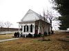
| 2 | Free Hills Rosenwald School |  |
November 15, 1996 (#96001360) |
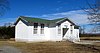
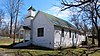
Free Hill Rd., east of State Route 52 36°33′46″N 85°29′13″W / 36.562639°N 85.486944°W / 36.562639; -85.486944 (Free Hills Rosenwald School) | Free Hill | One of only about 30 Rosenwald schools still extant, was built to educate African Americans and used from circa 1925 to 1966. |
| Name on the Register | Image | Date listed | Location | City or town | Description | |
|---|---|---|---|---|---|---|
| 1 | Bank of Alamo | 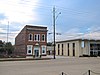 |
June 26, 1986 (#86001397) |
103 S. Bells St. 35°47′06″N 89°07′02″W / 35.785°N 89.117222°W / 35.785; -89.117222 (Bank of Alamo) | Alamo | Built in 1912 |
| 2 | Fruitvale Historic District | Upload image | November 14, 2012 (#12000943) |
Along Fruitvale Rd. & Jct. with Edward Williams Rd. 35°44′49″N 89°01′50″W / 35.746913°N 89.030521°W / 35.746913; -89.030521 (Fruitvale Historic District) | Fruitvale |


Former listing
| Name on the Register | Image | Date listed | Date removed | Location | City or town | Description | |
|---|---|---|---|---|---|---|---|
| 1 | Caplinger-Smith House | Upload image | February 12, 1980 (#80004296) | April 20, 1989 | SW Temperance Hall | Temperance Hall |
| Name on the Register | Image | Date listed | Location | City or town | Description | |
|---|---|---|---|---|---|---|
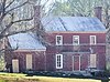
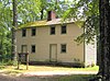
| 1 | Dr. Beauregard Martin Brooks House | Upload image | September 3, 1992 (#92001074) |
State Route 114 (Clifton Ferry Rd.) east of its junction with State Route 69 35°26′21″N 88°05′21″W / 35.439167°N 88.089167°W / 35.439167; -88.089167 (Dr. Beauregard Martin Brooks House) | Bath Springs | |
| 2 | Brownsport I Furnace (40DR85) | Upload image | July 28, 1988 (#88001144) |
Address Restricted | Gumdale | |
| 3 | Brownsport II Furnace (40DR86) | Upload image | August 26, 1977 (#77001265) |
Address Restricted | Decaturville | |
| 4 | Decatur Furnace (40DR84) | Upload image | July 28, 1988 (#88001142) |
Address Restricted | Bath Springs | |
| 5 | John P. Rains Hotel |  |
November 21, 1978 (#78002585) |
106-108 Tennessee Ave., S. 35°38′58″N 88°07′35″W / 35.649306°N 88.126389°W / 35.649306; -88.126389 (John P. Rains Hotel) | Parsons |


Former listing
| Name on the Register | Image | Date listed | Date removed | Location | City or town | Description | |
|---|---|---|---|---|---|---|---|
| 1 | Dyersburg Sanatarium | Upload image | September 8, 1976 (#76002241) | December 9, 1976 | 124 McGaughey | Dyersburg | Demolished. |
| Name on the Register | Image | Date listed | Location | City or town | Description | |
|---|---|---|---|---|---|---|
| 1 | Old Jail |  |
April 11, 1973 (#73001784) |
Jail St. 36°31′46″N 83°13′00″W / 36.529444°N 83.216667°W / 36.529444; -83.216667 (Old Jail) | Sneedville | |
| 2 | Vardy School Community Historic District |  |
November 8, 1984 (#84000373) |
Blackwater Rd. 36°35′03″N 83°11′19″W / 36.584167°N 83.188611°W / 36.584167; -83.188611 (Vardy School Community Historic District) | Sneedville | The school has collapsed, but other structures in the district intact and preserved. |


| Name on the Register | Image | Date listed | Location | City or town | Description | |
|---|---|---|---|---|---|---|
| 1 | Erin Limekilns | 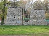 |
November 10, 2004 (#04001230) |
708 McMillan St. 36°18′57″N 87°42′52″W / 36.315833°N 87.714444°W / 36.315833; -87.714444 (Erin Limekilns) | Erin | |
| 2 | V.R. Harris House |  |
August 18, 1983 (#83003040) |
Main St. 36°19′01″N 87°42′04″W / 36.316944°N 87.701111°W / 36.316944; -87.701111 (V.R. Harris House) | Erin | |
| 3 | Quarry Limekiln |  |
November 10, 2004 (#04001229) |
State Route 49, approximately 0.25 miles east of Denmark Rd. 36°19′01″N 87°42′44″W / 36.316944°N 87.712222°W / 36.316944; -87.712222 (Quarry Limekiln) | Erin |
| Name on the Register | Image | Date listed | Location | City or town | Description | |
|---|---|---|---|---|---|---|
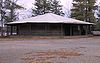
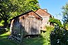
| 1 | Carverdale Farms |  |
July 31, 2018 (#100002754) |
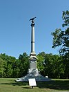
112 Harris Hollow Rd. 36°16′29″N 85°45′21″W / 36.2746°N 85.7559°W / 36.2746; -85.7559 (Carverdale Farms) | Granville | Farm first settled in 1830 by Joseph Williamson and family in the small community of Liberty just east of Granville. Historic home built in 1850 by Andrew Jackson Vantrease. Samuel Sampson Carver purchased property in 1890, operating a saw mill, blacksmith shop, and general store in addition to his agricultural uses. Farm was used for maneuver training during World War II. On October 24, 1955, current owner and great grandson of Carver, Joe Moore, was featured on the cover of Time magazine after being named 1955 Star Farmer of America. Contributing buildings range in construction dates from 1830 to 1945. |
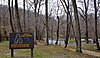
| 2 | Fort Blount-Williamsburg Site |  |
July 17, 1974 (#74001918) |
On the Cumberland River south of Gainesboro 36°19′09″N 85°45′05″W / 36.319167°N 85.751389°W / 36.319167; -85.751389 (Fort Blount-Williamsburg Site) | Gainesboro | Site of Fort Blount (1794-1798) and later town of Williamsburg (founded 1807) |
| 3 | Gainesboro Historic District | 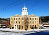 |
October 25, 1990 (#90001570) |
Roughly bounded by Cox, Minor, Montpelier, and Mark Twain Sts. 36°21′19″N 85°39′29″W / 36.355278°N 85.658056°W / 36.355278; -85.658056 (Gainesboro Historic District) | Gainesboro | |
| 4 | Gainesboro Residential Historic District |  |
July 11, 2001 (#01000728) |
Roughly along Dixie Ave. and Cox, Minor, and N. Murray Sts. 36°21′24″N 85°39′30″W / 36.356667°N 85.658333°W / 36.356667; -85.658333 (Gainesboro Residential Historic District) | Gainesboro | |
| 5 | Jackson County High School |  |
July 8, 2009 (#09000535) |
707 School Dr. 36°20′49″N 85°39′26″W / 36.346925°N 85.657139°W / 36.346925; -85.657139 (Jackson County High School) | Gainesboro | |
| 6 | T.B. Sutton General Store |  |
May 7, 2019 (#100003902) |
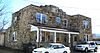
169 Clover St. 36°16′18″N 85°47′50″W / 36.271750°N 85.797084°W / 36.271750; -85.797084 (T.B. Sutton General Store) | Granville | Constructed in 1880, Sutton Store is the oldest remaining commercial institution in Granville. The store sat empty for approximately thirty years before Harold and Beverley Sutton (no relation to T.B. Sutton) purchased and restored the building. In 2007, they donated the building to Historic Granville Incorporated who continue to operate the building as a general store, restaurant, and music venue. Sutton Store has been recently recognized by Country Living and Taste of the South magazines as one of the must see general stores in America. |


Former listing
| Name on the Register | Image | Date listed | Date removed | Location | City or town | Description | |
|---|---|---|---|---|---|---|---|
| 1 | Rhea House | Upload image | April 11, 1973 (#73001799) | March 20, 1997 | U.S. Route 421 36°26′38″N 81°47′49″W / 36.443889°N 81.796944°W / 36.443889; -81.796944 (Rhea House) | Shouns | Destroyed by fire |
| Name on the Register | Image | Date listed | Location | City or town | Description | |
|---|---|---|---|---|---|---|
| 1 | Caldwell-Hopson House |  |
March 11, 1993 (#93000150) |
431 Wynn St. 36°22′34″N 89°28′50″W / 36.376111°N 89.480556°W / 36.376111; -89.480556 (Caldwell-Hopson House) | Tiptonville |


Former listings
| Name on the Register | Image | Date listed | Date removed | Location | City or town | Description | |
|---|---|---|---|---|---|---|---|
| 1 | Keystone School | Upload image | February 22, 1993 (#93000031) | July 22, 2014 | State Route 52 west of Lafayette, just east of Gap of the Ridge 36°31′25″N 86°06′31″W / 36.523611°N 86.108611°W / 36.523611; -86.108611 (Keystone School) | Lafayette |
| Name on the Register | Image | Date listed | Location | City or town | Description | |
|---|---|---|---|---|---|---|
| 1 | Bethel Springs Presbyterian Church | 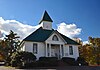 |
August 18, 1983 (#83003054) |
3rd Ave. 35°13′57″N 88°36′25″W / 35.2325°N 88.606944°W / 35.2325; -88.606944 (Bethel Springs Presbyterian Church) | Bethel Springs | |
| 2 | Big Hill Pond Fortification |  |
September 29, 1998 (#98001182) |
John Howell Rd. and the former Southern railroad line 35°02′12″N 88°44′06″W / 35.036667°N 88.735°W / 35.036667; -88.735 (Big Hill Pond Fortification) | Pocahontas | |
| 3 | Davis Bridge Battlefield | 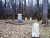 |
July 13, 1998 (#97001549) |
Roughly along Ripley-Pocahontas and Essary Spring Rds 35°01′51″N 88°47′44″W / 35.030833°N 88.795556°W / 35.030833; -88.795556 (Davis Bridge Battlefield) | Pocahontas | Extends into Hardeman County |
| 4 | Wray's Bluff Fortification | Upload image | September 29, 1998 (#98001183) |
Address Restricted | Pocahontas |
| Name on the Register | Image | Date listed | Location | City or town | Description | |
|---|---|---|---|---|---|---|
| 1 | Bobo Hotel |  |
April 7, 1994 (#94000283) |
Main St. 35°17′03″N 86°22′10″W / 35.284167°N 86.369444°W / 35.284167; -86.369444 (Bobo Hotel) | Lynchburg | Built late 1850s by E.Y. Salmon, operated as boarding house during the 20th century by Jack and Mary Bobo; once a frequent meeting place for Jack Daniel's executives |
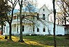
| 2 | Green-Evans House |  |
December 17, 1992 (#92001713) |
Old State Route 55 north of Lynchburg 35°18′09″N 86°21′54″W / 35.3025°N 86.365°W / 35.3025; -86.365 (Green-Evans House) | Lynchburg | Built by Townsend P. Green in mid-19th century; contains interior painted by noted regional painter Fred Swanton |
| 3 | Jack Daniel Distillery |  |
September 14, 1972 (#72001248) |
State Route 55 35°17′04″N 86°22′03″W / 35.284444°N 86.3675°W / 35.284444; -86.3675 (Jack Daniel Distillery) | Lynchburg | |
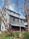
| 4 | Ledfords Mill |  |
January 10, 1985 (#85000077) |
1195 Shipman Creek Rd. 35°24′12″N 86°16′34″W / 35.403333°N 86.276111°W / 35.403333; -86.276111 (Ledfords Mill) | Tullahoma | |
| 5 | Lynchburg Historic District |  |
July 19, 1996 (#96000771) |
Roughly bounded by Majors, Main, Elm, and Wall Sts. 35°16′56″N 86°22′28″W / 35.282222°N 86.374444°W / 35.282222; -86.374444 (Lynchburg Historic District) | Lynchburg | Contains several dozen buildings in the downtown Lynchburg area |
| 6 | Moore County Courthouse and Jail |  |
September 26, 1979 (#79002452) |
Court Sq. 35°16′55″N 86°22′25″W / 35.281944°N 86.373611°W / 35.281944; -86.373611 (Moore County Courthouse and Jail) | Lynchburg | Courthouse built in 1885; Old jail (now a museum) located across the street from the courthouse, built in 1893 |


| Name on the Register | Image | Date listed | Location | City or town | Description | |
|---|---|---|---|---|---|---|
| 1 | Cordell Hull Birthplace | 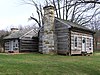 |
May 5, 1972 (#72001250) |
About 2 miles west of Byrdstown 36°34′55″N 85°11′02″W / 36.5819°N 85.1839°W / 36.5819; -85.1839 (Cordell Hull Birthplace) | Byrdstown | The birthplace cabin of U.S. Secretary of State Cordell Hull |
| 2 | Pickett County Courthouse |  |
March 30, 1995 (#95000338) |
Town Sq. 36°34′11″N 85°07′44″W / 36.5697°N 85.1289°W / 36.5697; -85.1289 (Pickett County Courthouse) | Byrdstown | |
| 3 | Pickett State Rustic Park Historic District |  |
July 8, 1986 (#86002795) |
Pickett State Park and Forest 36°33′25″N 84°47′43″W / 36.5569°N 84.7953°W / 36.5569; -84.7953 (Pickett State Rustic Park Historic District) | Jamestown | Contains several park structures built by the CCC in the 1930s and 1940s |


Former listings
| Name on the Register | Image | Date listed | Date removed | Location | City or town | Description | |
|---|---|---|---|---|---|---|---|
| 1 | Huntsville High School | Upload image | July 2, 1987 (#87001119) | February 7, 1996 | 220 E. Main St. | Huntsville | |
| 2 | Paint Rock Creek Covered Bridge | Upload image | April 18, 1977 (#77001287) | June 19, 1980 | SE of Huntsville on Jacksboro Rd. | Huntsville vicinity | Destroyed by fire in March, 1980. |


| Name on the Register | Image | Date listed | Location | City or town | Description | |
|---|---|---|---|---|---|---|
| 1 | A.R. Brown House |  |
November 8, 2007 (#07001167) |
241 S. Main Ave. 36°08′38″N 82°25′07″W / 36.1439°N 82.4186°W / 36.1439; -82.4186 (A.R. Brown House) | Erwin | |
| 2 | Clarksville Iron Furnace | Upload image | June 4, 1973 (#73001852) |
Southwest of Erwin off State Route 107 in the Cherokee National Forest 36°08′53″N 82°31′40″W / 36.1481°N 82.5278°W / 36.1481; -82.5278 (Clarksville Iron Furnace) | Erwin | In Cherokee National Forest |
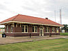
| 3 | Clinchfield Depot |  |
June 22, 1993 (#93000530) |
Junction of Nolichucky Ave. and Union St. 36°08′43″N 82°25′08″W / 36.1453°N 82.4189°W / 36.1453; -82.4189 (Clinchfield Depot) | Erwin | |
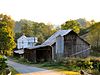
| 4 | Tilson Farm | Upload image | June 17, 1994 (#94000613) |
242 Little Branch Rd. 36°02′12″N 82°31′55″W / 36.0368°N 82.5320°W / 36.0368; -82.5320 (Tilson Farm) | Flag Pond |


| Name on the Register | Image | Date listed | Location | City or town | Description | |
|---|---|---|---|---|---|---|
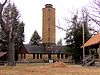
| 1 | Big Bone Cave |  |
April 11, 1973 (#73001853) |
East of Bone Cave and west of the summit of Tandy Knob 35°46′38″N 85°33′19″W / 35.7772°N 85.5553°W / 35.7772; -85.5553 (Big Bone Cave) | Bone Cave | |
| 2 | Crain Hill School and Church |  |
March 21, 1985 (#85000622) |
Crain Hill Rd. 35°43′02″N 85°35′18″W / 35.7172°N 85.5883°W / 35.7172; -85.5883 (Crain Hill School and Church) | Crain Hill | Built in 1870 |
| 3 | Higginbotham Turnpike | Upload image | July 20, 2020 (#100005368) |
Pleasant Hill Cemetery Rd. 35°35′29″N 85°31′30″W / 35.5913°N 85.5250°W / 35.5913; -85.5250 (Higginbotham Turnpike) | Spencer | |
| 4 | Rocky River Crossing and Road | Upload image | November 15, 2006 (#06001038) |
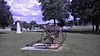
Rocky River and a continuation of Pleasant Hill Cemetery Rd. 35°35′33″N 85°31′11″W / 35.5925°N 85.5197°W / 35.5925; -85.5197 (Rocky River Crossing and Road) | Spencer | A Trail of Tears site |


See also
References
- Tennessee Historical Commission. "A FUTURE FOR THE PAST: A COMPREHENSIVE PLAN FOR HISTORIC PRESERVATION IN TENNESSEE, 2013-2018" (PDF). Archived from the original (PDF) on October 12, 2013. Retrieved February 3, 2014.
- The latitude and longitude information provided in this table was derived originally from the National Register Information System, which has been found to be fairly accurate for about 99% of listings. Some locations in this table may have been corrected to current GPS standards.
- National Park Service, United States Department of the Interior, "National Register of Historic Places: Weekly List Actions", retrieved September 20, 2024.
- ^ "National Register Information System". National Register of Historic Places. National Park Service. April 24, 2008.
- "National Register of Historic Places: Weekly List Actions". National Park Service. Archived from the original on January 26, 2011. Retrieved January 2, 2009.
- Weekly List Actions, National Register of Historic Places website
- The following sites are listed in multiple counties: Blythe Ferry (Meigs and Rhea), Boatyard Historic District (Hawkins and Sullivan), Bolivar-Somerville Stage Road (Fayette and Hardeman), Calderwood Dam (Blount and Monroe), Conway Bridge (Cocke and Greene), John Gordon House (Hickman and Maury), Great Falls Hydroelectric Station (Warren and White), Hastings-Locke Ferry (Meigs and Rhea), Norris Hydroelectric Project (Anderson and Campbell), Old Natchez Trace (Davidson, Hickman, Lawrence, Lewis, Maury, Wayne, and Williamson), Palmetto Farm (Bedford and Marshall), Petersburg Historic District (Fayette and Lincoln), Rugby Colony (Morgan and Scott), Shelby Bend Archeological District (Hickman and Maury), Davis Bridge Battlefield (Hardeman and McNairy), Boone Hydroelectric Project (Sullivan and Washington), Warner Park Historic Park (Davidson and Williamson), and Watts Bar Hydroelectric Project (Meigs and Rhea).
- ^ Numbers represent an alphabetical ordering by significant words. Various colorings, defined here, differentiate National Historic Landmarks and historic districts from other NRHP buildings, structures, sites or objects.
- ^ The eight-digit number below each date is the number assigned to each location in the National Register Information System database, which can be viewed by clicking the number.
- ^ "Trail Of Tears National Historic Trail: National Register Research". National Park Service. Retrieved January 22, 2013.
- Address based on USPS website. Accessed April 9, 2016.
- Location derived from this Harpeth River State Park map; the NRIS lists it as "Address Restricted"
- Pioneer in local medical field dies at 94 State Gazette. March 4, 2008 Archived March 9, 2008, at the Wayback Machine
- Carolyn Sakowski (2007), Touring the East Tennessee Backroads, John F. Blair, Publisher. ISBN 0-89587-350-8, ISBN 978-0-89587-350-7. Pages 28-29.
- Tennessee Architectural List TN.gov Historical Sites list
- "Cedar Grove Furnace (historical)". Geographic Names Information System. United States Geological Survey, United States Department of the Interior.
- Hiwassee Garrison (historical), GNIS, 1989-10-01.
- Trent, Kim (March 27, 2009). "Resurrection in Sharps Chapel". Saving Places. Metro Pulse.com. Archived from the original on June 5, 2009.
- Location derived from a notice on USGS topographical maps accessible from this GNIS feature record; the NRIS lists the site as "Address Restricted"
| Topics | |
|---|---|
| Lists by state |
|
| Lists by insular areas | |
| Lists by associated state | |
| Other areas | |
| Related | |