| Name
|
Address
|
Coordinates
|
Government recognition (CRHP №)
|

|
Image
|
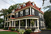
| 565 Aberdeen Street
|
565 Aberdeen Street
Fredericton NB
|
45°57′21″N 66°38′39″W / 45.9558°N 66.6441°W / 45.9558; -66.6441 (565 Aberdeen Street)
|
Fredericton municipality (17262)
|
|

Upload Photo
|
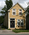
| Allen House
|
868 George Street
Fredericton NB
|
45°57′20″N 66°38′08″W / 45.9556°N 66.6356°W / 45.9556; -66.6356 (Allen House)
|
Fredericton municipality (2997)
|
|

More images
|
| Arts Building
|
3 Bailey Drive
Fredericton NB
|
45°56′54″N 66°38′29″W / 45.9483°N 66.6413°W / 45.9483; -66.6413 (Arts Building National Historic Site of Canada)
|
Federal (7369)
|
|

More images
|
| Auld Kirk
|
433 Charlotte Street
Fredericton NB
|
45°57′32″N 66°38′45″W / 45.9590°N 66.6457°W / 45.9590; -66.6457 (Auld Kirk)
|
Fredericton municipality (17201)
|
|
Upload Photo
|
| 441 Balsa Street
|
441 Balsa Street
Fredericton NB
|
45°58′15″N 66°38′11″W / 45.9707°N 66.6364°W / 45.9707; -66.6364 (441 Balsa Street)
|
Fredericton municipality (17203)
|
|
Upload Photo
|
| Beaverbrook Art Gallery
|
703 Queen Street
Fredericton NB
|
45°57′36″N 66°38′08″W / 45.96°N 66.6356°W / 45.96; -66.6356 (Beaverbrook Art Gallery)
|
Fredericton municipality (16982)
|
|

More images
|
| Lady Beaverbrook Rink
|
411 University Avenue
Fredericton NB
|
45°57′03″N 66°38′19″W / 45.9508°N 66.6387°W / 45.9508; -66.6387 (Lady Beaverbrook Rink)
|
Fredericton municipality (16983)
|
|

More images
|
| 42 Bridge Street
|
42 Bridge Street
Fredericton NB
|
45°58′44″N 66°35′10″W / 45.9788°N 66.586°W / 45.9788; -66.586 (42 Bridge Street)
|
Fredericton municipality (18442)
|
|
Upload Photo
|
| 185 Canada Street
|
185 Canada Street
Fredericton NB
|
45°58′22″N 66°35′27″W / 45.9729°N 66.5909°W / 45.9729; -66.5909 (185 Canada Street)
|
Fredericton municipality (18443)
|
|
Upload Photo
|
| 189 Canada Street
|
189 Canada Street
Fredericton NB
|
45°58′24″N 66°35′28″W / 45.9733°N 66.5911°W / 45.9733; -66.5911 (189 Canada Street)
|
Fredericton municipality (18434)
|
|
Upload Photo
|
| 299 Canada Street
|
299 Canada Street
Fredericton NB
|
45°58′54″N 66°35′34″W / 45.9817°N 66.5928°W / 45.9817; -66.5928 (299 Canada Street)
|
Fredericton municipality (12835)
|
|
Upload Photo
|
| 329 Canada Street
|
329 Canada Street
Fredericton NB
|
45°59′03″N 66°35′33″W / 45.9842°N 66.5924°W / 45.9842; -66.5924 (329 Canada Street)
|
Fredericton municipality (18436)
|
|
Upload Photo
|
| 335-337 Canada Street
|
335-337 Canada Street
Fredericton NB
|
45°59′06″N 66°35′33″W / 45.9851°N 66.5925°W / 45.9851; -66.5925 (335-337 Canada Street)
|
Fredericton municipality (17022)
|
|
Upload Photo
|
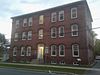
| Canadian Pacific Railway Station
|
380 York Street
Fredericton NB
|
45°57′24″N 66°38′55″W / 45.9567°N 66.6486°W / 45.9567; -66.6486 (Canadian Pacific Railway Station)
|
Federal (4520)
|
|
Upload Photo
|
| All Saints Anglican Church
|
150 Crock's Point Road
Bright Parish NB
|
45°58′00″N 66°50′51″W / 45.9668°N 66.8475°W / 45.9668; -66.8475 (All Saints Anglican Church)
|
Bright Parish municipality (2212)
|
|
Upload Photo
|
| Caretaker's Cottage
|
303 Odell Avenue
Fredericton NB
|
45°57′44″N 66°39′21″W / 45.9623°N 66.6558°W / 45.9623; -66.6558 (Caretaker's Cottage)
|
Fredericton municipality (13126)
|
|
Upload Photo
|
| 120 Carleton Street
|
120 Carleton Street
Fredericton NB
|
45°57′38″N 66°38′30″W / 45.9605°N 66.6417°W / 45.9605; -66.6417 (120 Carleton Street)
|
Fredericton municipality (4097)
|
|
Upload Photo
|
| Bliss Carman House
|
83 Shore Street
Fredericton NB
|
45°57′12″N 66°38′00″W / 45.9534°N 66.6334°W / 45.9534; -66.6334 (Bliss Carman House)
|
Fredericton municipality (13035)
|
|

More images
|
| Carriage House Inn
|
230 University Avenue
Fredericton NB
|
45°57′20″N 66°38′02″W / 45.9556°N 66.6339°W / 45.9556; -66.6339 (Carriage House Inn)
|
Fredericton municipality (2881)
|
|
More images
|
| Charlotte Street School
|
732 Charlotte Street
Fredericton NB
|
45°57′21″N 66°38′21″W / 45.9557°N 66.6393°W / 45.9557; -66.6393 (Charlotte Street School)
|
New Brunswick (11440),
Fredericton municipality (12994)
|
|

More images
|
| 650 Charlotte Street
|
650 Charlotte Street
Fredericton NB
|
45°57′24″N 66°38′28″W / 45.9567°N 66.641°W / 45.9567; -66.641 (650 Charlotte Street)
|
Fredericton municipality (12265)
|
|

More images
|
| 818 Charlotte Street
|
818 Charlotte Street
Fredericton NB
|
45°57′18″N 66°38′14″W / 45.9551°N 66.6371°W / 45.9551; -66.6371 (818 Charlotte Street)
|
Fredericton municipality (17204)
|
|

More images
|
| 871 Charlotte Street
|
871 Charlotte Street
Fredericton NB
|
45°57′18″N 66°38′09″W / 45.9549°N 66.6357°W / 45.9549; -66.6357 (871 Charlotte Street)
|
Fredericton municipality (16842)
|
|
More images
|
| Christ Church Cathedral National Historic Site of Canada
|
100 Brunswick Street
Fredericton NB
|
45°57′50″N 66°39′05″W / 45.9639°N 66.6513°W / 45.9639; -66.6513 (Christ Church Cathedral National Historic Site of Canada)
|
Federal (11974)
|
|

|
| The Church of St. Mary the Virgin
|
373 New Maryland Highway
New Maryland NB
|
45°53′27″N 66°41′03″W / 45.8907°N 66.6843°W / 45.8907; -66.6843 (The Church of St. Mary the Virgin)
|
New Brunswick (2877)
|
|

More images
|
| CPR Company House - Klondike
|
49 Rockland Drive
McAdam NB
|
45°35′38″N 67°19′42″W / 45.5938°N 67.3284°W / 45.5938; -67.3284 (CPR Company House - Klondike)
|
McAdam municipality (12288)
|
|
Upload Photo
|
| CPR Company House - 30 Lake Avenue
|
30 Lake Avenue
McAdam NB
|
45°35′43″N 67°19′48″W / 45.5952°N 67.3299°W / 45.5952; -67.3299 (CPR Company House - 30 Lake Avenue)
|
McAdam municipality (12286)
|
|
Upload Photo
|
| CPR Company House - 101 Saunders Road
|
101 Saunders Road
McAdam NB
|
45°35′29″N 67°19′45″W / 45.5914°N 67.3291°W / 45.5914; -67.3291 (CPR Company House - 101 Saunders Road)
|
McAdam municipality (10577)
|
|
Upload Photo
|
| Crocket House
|
796 Queen Street
Fredericton NB
|
45°57′31″N 66°38′06″W / 45.9585°N 66.6349°W / 45.9585; -66.6349 (Crocket House)
|
Fredericton municipality (4069)
|
|

More images
|
| Diggity Site
|
Diggity Cove
McAdam NB
|
45°37′40″N 67°26′00″W / 45.6278°N 67.4332°W / 45.6278; -67.4332 (Diggity Site)
|
New Brunswick (7989)
|
|
Upload Photo
|
| 6 Downing Street
|
6 Downing Street
Fredericton NB
|
45°58′46″N 66°35′07″W / 45.9795°N 66.5852°W / 45.9795; -66.5852 (6 Downing Street)
|
Fredericton municipality (18439)
|
|
Upload Photo
|
| 8 Downing Street
|
8 Downing Street
Fredericton NB
|
45°58′47″N 66°35′07″W / 45.9797°N 66.5852°W / 45.9797; -66.5852 (8 Downing Street)
|
Fredericton municipality (18440)
|
|
Upload Photo
|
| 14 Downing Street
|
14 Downing Street
Fredericton NB
|
45°58′49″N 66°35′07″W / 45.9802°N 66.5853°W / 45.9802; -66.5853 (14 Downing Street)
|
Fredericton municipality (18441)
|
|
Upload Photo
|
| Engine 29 and Firetruck Display Building
|
146 Saunders Road
McAdam NB
|
45°35′47″N 67°19′57″W / 45.5963°N 67.3326°W / 45.5963; -67.3326 (Engine 29 and Firetruck Display Building)
|
McAdam municipality (12289)
|
|
Upload Photo
|
| First McAdam Railway Station
|
11 Granite Street
McAdam NB
|
45°35′37″N 67°19′56″W / 45.5937°N 67.3323°W / 45.5937; -67.3323 (First McAdam Railway Station)
|
McAdam municipality (10554)
|
|
Upload Photo
|
| Forest Hill Cemetery
|
325 Forest Hill Road
Fredericton NB
|
45°56′20″N 66°38′12″W / 45.9389°N 66.6366°W / 45.9389; -66.6366 (Forest Hill Cemetery)
|
Fredericton municipality (12996)
|
|

More images
|
| Former Gibson Roundhouse
|
912-930 Union Street
Fredericton NB
|
45°57′30″N 66°37′27″W / 45.9583°N 66.6243°W / 45.9583; -66.6243 (Former Gibson Roundhouse)
|
Fredericton municipality (13132)
|
|
Upload Photo
|
| Former Marysville Hotel
|
7 Bridge Street
Fredericton NB
|
45°58′44″N 66°35′20″W / 45.979°N 66.589°W / 45.979; -66.589 (Former Marysville Hotel)
|
Fredericton municipality (18433)
|
|
More images
|
| Former New Brunswick Electric Power Commission Building
|
527 King Street
Fredericton NB
|
45°57′39″N 66°38′27″W / 45.9609°N 66.6409°W / 45.9609; -66.6409 (Former New Brunswick Electric Power Commission Building)
|
Fredericton municipality (17001)
|
|
Upload Photo
|
| Fort Nashwaak (Naxoat) National Historic Site of Canada
|
Carleton Park
Fredericton NB
|
45°57′42″N 66°37′31″W / 45.9618°N 66.6254°W / 45.9618; -66.6254 (Fort Nashwaak (Naxoat) National Historic Site of Canada)
|
Federal (13272)
|
|

|
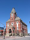
| Fredericton City Hall National Historic Site of Canada
|
397 Queen Street
Fredericton NB
|
45°57′49″N 66°38′35″W / 45.9635°N 66.6431°W / 45.9635; -66.6431 (Fredericton City Hall National Historic Site of Canada)
|
Federal (12722),
Fredericton municipality (12837)
|
|
More images
|
| Fredericton Water Treatment Plant
|
101 Smythe Street
Fredericton NB
|
45°57′55″N 66°39′04″W / 45.9653°N 66.6511°W / 45.9653; -66.6511 (Fredericton Water Treatment Plant)
|
Fredericton municipality (12962)
|
|
Upload Photo
|
| Frogmore
|
35 Colter Court
Fredericton NB
|
45°57′11″N 66°38′53″W / 45.953°N 66.648°W / 45.953; -66.648 (Frogmore)
|
Fredericton municipality (2879)
|
|
Upload Photo
|
| 522 George Street
|
522 George Street
Fredericton NB
|
45°57′32″N 66°38′34″W / 45.9588°N 66.6429°W / 45.9588; -66.6429 (522 George Street)
|
Fredericton municipality (13120)
|
|
Upload Photo
|
| 770 George Street
|
770 George Street
Fredericton NB
|
45°57′23″N 66°38′15″W / 45.9565°N 66.6376°W / 45.9565; -66.6376 (770 George Street)
|
Fredericton municipality (17184)
|
|

More images
|
| 806 George Street
|
806 George Street
Fredericton NB
|
45°57′22″N 66°38′11″W / 45.9561°N 66.6365°W / 45.9561; -66.6365 (806 George Street)
|
Fredericton municipality (13034)
|
|

More images
|
| 844 George Street
|
844 George Street
Fredericton NB
|
45°57′21″N 66°38′09″W / 45.9558°N 66.6357°W / 45.9558; -66.6357 (844 George Street)
|
Fredericton municipality (12266)
|
|

More images
|
| Gibson Family Plot
|
351 Canada Street
Fredericton NB
|
45°59′14″N 66°35′41″W / 45.9871°N 66.5947°W / 45.9871; -66.5947 (Gibson Family Plot)
|
Fredericton municipality (18437)
|
|
Upload Photo
|
| Gill House
|
968 Riverside Drive
Fredericton NB
|
45°55′48″N 66°36′04″W / 45.93°N 66.601°W / 45.93; -66.601 (Gill House)
|
Fredericton municipality (13000)
|
|
Upload Photo
|
| Glacier Rock
|
Saunders Road
McAdam NB
|
45°35′23″N 67°19′48″W / 45.5897°N 67.3299°W / 45.5897; -67.3299 (Glacier Rock)
|
McAdam municipality (10558)
|
|
Upload Photo
|
| Government of Canada Building
|
633 Queen Street
Fredericton NB
|
45°57′40″N 66°38′18″W / 45.9610°N 66.6383°W / 45.9610; -66.6383 (Government of Canada Building)
|
Federal (11053)
|
|
Upload Photo
|
| Mary Evelyn Grannan House
|
325 Brunswick Street
Fredericton NB
|
45°57′43″N 66°38′47″W / 45.9619°N 66.6463°W / 45.9619; -66.6463 (Mary Evelyn Grannan House)
|
New Brunswick (2361)
|
|
Upload Photo
|
| 21 Grey Street
|
21 Grey Street
Fredericton NB
|
45°57′03″N 66°38′14″W / 45.9509°N 66.6373°W / 45.9509; -66.6373 (21 Grey Street)
|
Fredericton municipality (12281)
|
|

More images
|
| Hartt Boot and Shoe Factory
|
401 York Street
Fredericton NB
|
45°57′22″N 66°38′58″W / 45.9561°N 66.6495°W / 45.9561; -66.6495 (Hartt Boot and Shoe Factory)
|
Fredericton municipality (2850)
|
|
Upload Photo
|
| Hatt House
|
293 Canada Street
Fredericton NB
|
45°58′52″N 66°35′34″W / 45.9811°N 66.5929°W / 45.9811; -66.5929 (Hatt House)
|
Fredericton municipality (18435)
|
|
Upload Photo
|
| 42nd Highland Memorial Cemetery
|
Route 8
Saint Marys Parish NB
|
46°12′44″N 66°36′48″W / 46.2123°N 66.6133°W / 46.2123; -66.6133 (42nd Highland Memorial Cemetery)
|
New Brunswick (7441)
|
|
More images
|
| Holy Trinity Anglican Church
|
Highway 105
Lower Saint Marys NB
|
45°55′21″N 66°35′16″W / 45.9225°N 66.5878°W / 45.9225; -66.5878 (Holy Trinity Anglican Church)
|
New Brunswick (2713)
|
|
Upload Photo
|
| Howe Family Property
|
730-750 Howe Street
Fredericton NB
|
45°59′12″N 66°37′26″W / 45.9866°N 66.6238°W / 45.9866; -66.6238 (Howe Family Property)
|
Fredericton municipality (17183)
|
|
Upload Photo
|
| William Brydone Jack Observatory
|
3 Bailey Drive
Fredericton NB
|
45°33′54″N 66°22′59″W / 45.565°N 66.383°W / 45.565; -66.383 (William Brydone Jack Observatory)
|
Federal (9981)
|
|

More images
|
| Kilburn House
|
155 Smythe Street
Fredericton NB
|
45°57′50″N 66°39′08″W / 45.9639°N 66.6521°W / 45.9639; -66.6521 (Kilburn House)
|
Fredericton municipality (12263)
|
|
Upload Photo
|
| 260 Kings College Road
|
260 Kings College Road
Fredericton NB
|
45°57′06″N 66°39′25″W / 45.9516°N 66.657°W / 45.9516; -66.657 (260 Kings College Road)
|
Fredericton municipality (16367)
|
|
Upload Photo
|
| Kings Landing Historical Settlement
|
20 Kings Landing Road (Route 2)
Prince William NB
|
45°52′00″N 66°57′15″W / 45.8666°N 66.9541°W / 45.8666; -66.9541 (Kings Landing Historical Settlement)
|
New Brunswick (6301)
|
|

More images
|
| Legislative Assembly Block
|
706 Queen Street
Fredericton NB
|
45°57′33″N 66°38′10″W / 45.9592°N 66.6361°W / 45.9592; -66.6361 (Legislative Assembly Block)
|
New Brunswick (1268)
|
|

More images
|
| Marysville Cenotaph
|
190 Canada Street
Fredericton NB
|
45°58′42″N 66°35′33″W / 45.9784°N 66.5924°W / 45.9784; -66.5924 (Marysville Cenotaph)
|
Fredericton municipality (18444)
|
|

More images
|
| Marysville Cotton Mill National Historic Site of Canada
|
8 River Street
Fredericton NB
|
45°58′43″N 66°35′18″W / 45.9785°N 66.5883°W / 45.9785; -66.5883 (Marysville Cotton Mill National Historic Site of Canada)
|
Federal (12664)
|
|

More images
|
| Marysville Historic District National Historic Site of Canada
|
centered on Mill and Canada Streets
Fredericton NB
|
45°58′43″N 66°35′32″W / 45.9786°N 66.5923°W / 45.9786; -66.5923 (Marysville Historic District National Historic Site of Canada)
|
Federal (7672)
|
|

|
| McAdam Heritage Park
|
Saunders Road
McAdam NB
|
45°35′24″N 67°19′47″W / 45.5899°N 67.3296°W / 45.5899; -67.3296 (McAdam Heritage Park)
|
McAdam municipality (10573)
|
|
Upload Photo
|
| McAdam Post Office
|
105 Saunders Road
McAdam NB
|
45°35′30″N 67°19′43″W / 45.5916°N 67.3287°W / 45.5916; -67.3287 (McAdam Post Office)
|
McAdam municipality (10542)
|
|
Upload Photo
|
| McAdam Railway Station (Canadian Pacific) National Historic Site of Canada
|
146 Saunders Road
McAdam NB
|
45°35′54″N 67°19′37″W / 45.5984°N 67.3269°W / 45.5984; -67.3269 (McAdam Railway Station (Canadian Pacific) National Historic Site of Canada)
|
Federal (3207, (6523),
New Brunswick (6476),
McAdam municipality (10553)
|
|

More images
|
| Meductic Indian Village / Fort Meductic National Historic Site of Canada
|
Fort Meductic Road
Lakeland Ridges NB
|
46°01′32″N 67°32′23″W / 46.0256°N 67.5398°W / 46.0256; -67.5398 (Meductic Indian Village / Fort Meductic National Historic Site of Canada)
|
Federal (14831)
|
|

More images
|
| Military Compound
|
Queen Street
Fredericton NB
|
45°57′45″N 66°38′29″W / 45.9626°N 66.6413°W / 45.9626; -66.6413 (Military Compound)
|
Federal (18989),
New Brunswick (7750)
|
|

|
| Morrison Building
|
514-516 Queen Street
Fredericton NB
|
45°57′42″N 66°38′27″W / 45.9617°N 66.6408°W / 45.9617; -66.6408 (Morrison Building)
|
Fredericton municipality (12244)
|
|
Upload Photo
|
| Morrison House
|
765 Charlotte Street
Fredericton NB
|
45°57′21″N 66°38′18″W / 45.9558°N 66.6383°W / 45.9558; -66.6383 (Morrison House)
|
Fredericton municipality (12264)
|
|
Upload Photo
|
| Mud Lake Stream Anthropological Site
|
North Lake Parish NB
|
45°40′58″N 67°42′59″W / 45.6829°N 67.7165°W / 45.6829; -67.7165 (Mud Lake Stream Anthropological Site)
|
New Brunswick (7991)
|
|
Upload Photo
|
| Neill House
|
255 Church Street
Fredericton NB
|
45°57′19″N 66°38′16″W / 45.9554°N 66.6378°W / 45.9554; -66.6378 (Neill House)
|
Fredericton municipality (17243)
|
|

More images
|
| 178 Northumberland Street
|
178 Northumberland Street
Fredericton NB
|
45°57′45″N 66°38′58″W / 45.9624°N 66.6495°W / 45.9624; -66.6495 (178 Northumberland Street)
|
Fredericton municipality (17241)
|
|
Upload Photo
|
| 216 Odell Avenue
|
216 Odell Avenue
Fredericton NB
|
45°57′48″N 66°39′15″W / 45.9634°N 66.6542°W / 45.9634; -66.6542 (216 Odell Avenue)
|
Fredericton municipality (12983)
|
|
Upload Photo
|
| 226 Odell Avenue
|
226 Odell Avenue
Fredericton NB
|
45°57′48″N 66°39′15″W / 45.9633°N 66.6543°W / 45.9633; -66.6543 (226 Odell Avenue)
|
Fredericton municipality (12993)
|
|
Upload Photo
|
| 234-236 Odell Avenue
|
234-236 Odell Avenue
Fredericton NB
|
45°57′47″N 66°39′16″W / 45.9631°N 66.6544°W / 45.9631; -66.6544 (234-236 Odell Avenue)
|
Fredericton municipality (13117)
|
|
Upload Photo
|
| Old Burial Ground
|
500 Brunswick Street
Fredericton NB
|
45°57′36″N 66°38′34″W / 45.9599°N 66.6428°W / 45.9599; -66.6428 (Old Burial Ground)
|
Fredericton municipality (12919)
|
|
Upload Photo
|
| Old Fire Hall
|
441 King Street
Fredericton NB
|
45°57′42″N 66°38′36″W / 45.9618°N 66.6432°W / 45.9618; -66.6432 (Old Fire Hall)
|
Fredericton municipality (16822)
|
|
Upload Photo
|
| Old Government House
|
20 Woodstock Road
Fredericton NB
|
45°57′56″N 66°39′21″W / 45.9656°N 66.6559°W / 45.9656; -66.6559 (Old Government House)
|
Federal (7642),
New Brunswick (10620)
|
|
More images
|
| Palmer-McLellan Building
|
364 Argyle Street
Fredericton NB
|
45°57′23″N 66°38′59″W / 45.9564°N 66.6497°W / 45.9564; -66.6497 (Palmer-McLellan Building)
|
Fredericton municipality (4068)
|
|
Upload Photo
|
| Phoenix Square
|
397 Queen Street
Fredericton NB
|
45°57′48″N 66°38′36″W / 45.9632°N 66.6432°W / 45.9632; -66.6432 (Phoenix Square)
|
Fredericton municipality (17202)
|
|
Upload Photo
|
| Queen's Square
|
730 Aberdeen Street
Fredericton NB
|
45°57′12″N 66°38′27″W / 45.9534°N 66.6409°W / 45.9534; -66.6409 (Queen's Square)
|
Fredericton municipality (13138)
|
|

More images
|
| 279 Regent Street
|
279 Regent Street
Fredericton NB
|
45°57′25″N 66°38′33″W / 45.9569°N 66.6426°W / 45.9569; -66.6426 (279 Regent Street)
|
Fredericton municipality (17261)
|
|
Upload Photo
|
| 351 Regent Street
|
351 Regent Street
Fredericton NB
|
45°57′21″N 66°38′37″W / 45.9557°N 66.6437°W / 45.9557; -66.6437 (351 Regent Street)
|
Fredericton municipality (16802)
|
|
Upload Photo
|
| Royals Field
|
60 Morrison Street
Fredericton NB
|
45°58′57″N 66°35′15″W / 45.9824°N 66.5875°W / 45.9824; -66.5875 (Royals Field)
|
Fredericton municipality (18438)
|
|
Upload Photo
|
| St. Anne's Chapel of Ease
|
201 Westmorland Street
Fredericton NB
|
45°57′40″N 66°38′53″W / 45.961°N 66.6481°W / 45.961; -66.6481 (St. Anne's Chapel of Ease)
|
Federal (4443)
|
|

More images
|
| St. George's Anglican Church
|
53 Rockland Drive
McAdam NB
|
45°35′39″N 67°19′43″W / 45.5942°N 67.3286°W / 45.5942; -67.3286 (St. George's Anglican Church)
|
McAdam municipality (10589)
|
|
Upload Photo
|
| Saint John River
|
Fredericton NB
|
45°58′02″N 66°38′23″W / 45.9671°N 66.6397°W / 45.9671; -66.6397 (Saint John River)
|
Fredericton municipality (18451)
|
|

More images
|
| 261 St. John Street
|
261 St. John Street
Fredericton NB
|
45°57′22″N 66°38′24″W / 45.9562°N 66.6401°W / 45.9562; -66.6401 (261 St. John Street)
|
Fredericton municipality (12838)
|
|

More images
|
| St. John the Evangelist Church
|
74 Main Street
Fredericton NB
|
45°58′54″N 66°39′40″W / 45.9816°N 66.6610°W / 45.9816; -66.6610 (St. John the Evangelist Church)
|
Fredericton municipality (13124)
|
|
Upload Photo
|
| St. Mary's Departmental Store
|
69 Cliffe Street
Fredericton NB
|
45°58′11″N 66°38′05″W / 45.9697°N 66.6346°W / 45.9697; -66.6346 (St. Mary's Departmental Store)
|
Fredericton municipality (17021)
|
|
Upload Photo
|
| St. Paul's United Church
|
155 Saunders Road
McAdam NB
|
45°35′41″N 67°19′38″W / 45.5947°N 67.3272°W / 45.5947; -67.3272 (St. Paul's United Church)
|
McAdam municipality (10587)
|
|
Upload Photo
|
| St. Paul's United Church National Historic Site of Canada
|
500 George Street
Fredericton NB
|
45°57′35″N 66°38′39″W / 45.9596°N 66.6443°W / 45.9596; -66.6443 (St. Paul's United Church National Historic Site of Canada)
|
Federal (11934)
|
|
Upload Photo
|
| St. Peter's Anglican Church
|
2365 Woodstock Road
Fredericton NB
|
45°58′00″N 66°44′25″W / 45.9666°N 66.7403°W / 45.9666; -66.7403 (St. Peter's Anglican Church)
|
Fredericton municipality (17041)
|
|
Upload Photo
|
| 332 Saunders Street
|
332 Saunders Street
Fredericton NB
|
45°57′32″N 66°38′56″W / 45.9589°N 66.6488°W / 45.9589; -66.6488 (332 Saunders Street)
|
Fredericton municipality (18449)
|
|
Upload Photo
|
| 344 Saunders Street
|
344 Saunders Street
Fredericton NB
|
45°57′32″N 66°38′55″W / 45.9588°N 66.6485°W / 45.9588; -66.6485 (344 Saunders Street)
|
Fredericton municipality (18450)
|
|
Upload Photo
|
| Shrine to Saint Francis of Assisi
|
413 Upper Skiff Lake Road
Canterbury Parish NB
|
45°51′26″N 67°31′30″W / 45.8571°N 67.5251°W / 45.8571; -67.5251 (Shrine to Saint Francis of Assisi)
|
New Brunswick (9703)
|
|
Upload Photo
|
| Site of the Union Church and Burial Ground
|
Stannix Street
McAdam NB
|
45°35′49″N 67°19′27″W / 45.597°N 67.3242°W / 45.597; -67.3242 (Site of the Union Church and Burial Ground)
|
McAdam municipality (10563)
|
|
Upload Photo
|
| Smyth House
|
248 Smythe Street
Fredericton NB
|
45°57′31″N 66°38′09″W / 45.9586°N 66.6357°W / 45.9586; -66.6357 (Smyth House)
|
Fredericton municipality (4447)
|
|
Upload Photo
|
| 248 Smythe Street
|
248 Smythe Street
Fredericton NB
|
45°57′44″N 66°39′10″W / 45.9621°N 66.6527°W / 45.9621; -66.6527 (248 Smythe Street)
|
Fredericton municipality (13118)
|
|
Upload Photo
|
| Thorne Cottage
|
266 Golf Club Road
Fredericton NB
|
45°57′33″N 66°41′02″W / 45.9591°N 66.6838°W / 45.9591; -66.6838 (Thorne Cottage)
|
Fredericton municipality (12836)
|
|
Upload Photo
|
| 402 Union Street
|
402 Union Street
Fredericton NB
|
45°58′19″N 66°38′13″W / 45.972°N 66.637°W / 45.972; -66.637 (402 Union Street)
|
Fredericton municipality (17023)
|
|
Upload Photo
|
| 880 Union Street
|
880 Union Street
Fredericton NB
|
45°57′33″N 66°37′29″W / 45.9592°N 66.6247°W / 45.9592; -66.6247 (880 Union Street)
|
Fredericton municipality (18432)
|
|
Upload Photo
|
| 311 University Avenue
|
311 University Avenue
Fredericton NB
|
45°57′12″N 66°38′10″W / 45.9534°N 66.6361°W / 45.9534; -66.6361 (311 University Avenue)
|
Fredericton municipality (13593)
|
|

More images
|
| Victoriana Rose
|
193 Church Street
Fredericton NB
|
45°57′24″N 66°38′12″W / 45.9567°N 66.6367°W / 45.9567; -66.6367 (Victoriana Rose)
|
Fredericton municipality (17185)
|
|

More images
|
| Welsh Chapel
|
Route 620
Douglas NB
|
46°09′30″N 66°47′19″W / 46.1583°N 66.7887°W / 46.1583; -66.7887 (Welsh Chapel)
|
New Brunswick (6668)
|
|
Upload Photo
|
| 24 Waterloo Row
|
24 Waterloo Row
Fredericton NB
|
45°57′21″N 66°38′00″W / 45.9557°N 66.6332°W / 45.9557; -66.6332 (24 Waterloo Row)
|
Fredericton municipality (13114)
|
|

More images
|
| 50 Waterloo Row
|
50 Waterloo Row
Fredericton NB
|
45°57′17″N 66°37′59″W / 45.9547°N 66.633°W / 45.9547; -66.633 (50 Waterloo Row)
|
Fredericton municipality (16821)
|
|

More images
|
| 92 Waterloo Row
|
92 Waterloo Row
Fredericton NB
|
45°57′13″N 66°37′58″W / 45.9536°N 66.6328°W / 45.9536; -66.6328 (92 Waterloo Row)
|
Fredericton municipality (12959)
|
|

More images
|
| 327 Westmorland Street
|
327 Westmorland Street
Fredericton NB
|
45°57′32″N 66°39′00″W / 45.9588°N 66.65°W / 45.9588; -66.65 (327 Westmorland Street)
|
Fredericton municipality (18445)
|
|
Upload Photo
|
| 338 Westmorland Street
|
338 Westmorland Street
Fredericton NB
|
45°57′31″N 66°39′00″W / 45.9586°N 66.6499°W / 45.9586; -66.6499 (338 Westmorland Street)
|
Fredericton municipality (18446)
|
|
Upload Photo
|
| 348 Westmorland Street
|
348 Westmorland Street
Fredericton NB
|
45°57′30″N 66°39′00″W / 45.9584°N 66.65°W / 45.9584; -66.65 (348 Westmorland Street)
|
Fredericton municipality (18448)
|
|
Upload Photo
|
| Wilmot Park
|
20 Woodstock Road
Fredericton NB
|
45°57′49″N 66°39′25″W / 45.9635°N 66.6569°W / 45.9635; -66.6569 (Wilmot Park)
|
Fredericton municipality (13134)
|
|
Upload Photo
|
| Wilmot United Church
|
473 King Street
Fredericton NB
|
45°57′41″N 66°38′30″W / 45.9615°N 66.6418°W / 45.9615; -66.6418 (Wilmot United Church)
|
New Brunswick (6229)
|
|

More images
|
| Wolastoq National Historic Site of Canada
|
Entire watershed of Saint John River
central and western New Brunswick, parts of southeastern Quebec NB
|
45°58′01″N 66°40′11″W / 45.9669°N 66.6697°W / 45.9669; -66.6697 (Wolastoq National Historic Site of Canada)
|
Federal (18954)
|
|
More images
|
| World War II Bomber Crash Site Monument
|
92 Saunders Road
McAdam NB
|
45°35′24″N 67°19′46″W / 45.5901°N 67.3295°W / 45.5901; -67.3295 (World War II Bomber Crash Site Monument)
|
McAdam municipality (10560)
|
|
Upload Photo
|
| York County Court House National Historic Site
|
649 Queen Street
Fredericton NB
|
45°57′37″N 66°38′12″W / 45.9604°N 66.6368°W / 45.9604; -66.6368 (York County Court House National Historic Site of Canada)
|
Federal (4482)
|
|
Upload Photo
|
| York County Gaol
|
668 Brunswick Street
Fredericton NB
|
45°57′30″N 66°38′21″W / 45.9584°N 66.6391°W / 45.9584; -66.6391 (York County Gaol)
|
New Brunswick (6282)
|
|

More images
|
| York County Municipal Home Cemetery
|
115 Jewett Street
Fredericton NB
|
45°58′47″N 66°41′12″W / 45.9798°N 66.6867°W / 45.9798; -66.6867 (York County Municipal Home Cemetery)
|
Fredericton municipality (13125)
|
|
Upload Photo
|
| York Street School
|
193 York Street
Fredericton NB
|
45°57′38″N 66°38′43″W / 45.9606°N 66.6454°W / 45.9606; -66.6454 (York Street School)
|
Fredericton municipality (17242)
|
|
Upload Photo
|
| York Street Train Station
|
380-390 York Street
Fredericton NB
|
45°57′22″N 66°38′52″W / 45.9562°N 66.6477°W / 45.9562; -66.6477 (York Street Train Station)
|
Fredericton municipality (18121)
|
|
Upload Photo
|