| Name
|
Location
|
Date Listed
|
Grid Ref.
|
Geo-coordinates
|
Notes
|
LB Number
|
Image
|
| Kirk Wynd, Tulach Including Ancillary Buildings, Boundary Walls, Gatepiers And Gates
|
|
|
|
56°35′41″N 3°20′27″W / 56.594698°N 3.34072°W / 56.594698; -3.34072 (Kirk Wynd, Tulach Including Ancillary Buildings, Boundary Walls, Gatepiers And Gates)
|
Category B
|
22291
|

Upload Photo
|
| 23 - 27 (Odd Nos) High Street
|
|
|
|
56°35′33″N 3°20′24″W / 56.592387°N 3.340117°W / 56.592387; -3.340117 (23 - 27 (Odd Nos) High Street)
|
Category C(S)
|
22295
|
Upload Photo
|
| 20 And 22 Brown Street
|
|
|
|
56°35′33″N 3°20′28″W / 56.592537°N 3.341181°W / 56.592537; -3.341181 (20 And 22 Brown Street)
|
Category B
|
22307
|
Upload Photo
|
| John Street, St Stephen's Roman Catholic Primary School Including Boundary Walls, Gatepiers And Gates
|
|
|
|
56°35′33″N 3°20′42″W / 56.592369°N 3.345067°W / 56.592369; -3.345067 (John Street, St Stephen's Roman Catholic Primary School Including Boundary Walls, Gatepiers And Gates)
|
Category B
|
22313
|
Upload Photo
|
| 29 And 30 Wellmeadow, Bank Buildings
|
|
|
|
56°35′29″N 3°20′15″W / 56.591417°N 3.337575°W / 56.591417; -3.337575 (29 And 30 Wellmeadow, Bank Buildings)
|
Category B
|
22319
|
Upload Photo
|
| 31, 32 And 33 Wellmeadow
|
|
|
|
56°35′29″N 3°20′15″W / 56.591301°N 3.33749°W / 56.591301; -3.33749 (31, 32 And 33 Wellmeadow)
|
Category B
|
22320
|
Upload Photo
|
| Rattray (New), Mount Ericht Road, Bengarth Including Ancillary Building, Boundary Walls And Gatepiers
|
|
|
|
56°35′37″N 3°20′03″W / 56.593474°N 3.33426°W / 56.593474; -3.33426 (Rattray (New), Mount Ericht Road, Bengarth Including Ancillary Building, Boundary Walls And Gatepiers)
|
Category C(S)
|
22326
|
Upload Photo
|
| Emma Terrace, Brackenbrae Including Gatepiers, Boundary Walls And Railings
|
|
|
|
56°35′27″N 3°20′48″W / 56.590745°N 3.346573°W / 56.590745; -3.346573 (Emma Terrace, Brackenbrae Including Gatepiers, Boundary Walls And Railings)
|
Category C(S)
|
49422
|
Upload Photo
|
| 17 And 19 Newton Street Including Boundary Walls, Railings And Gates
|
|
|
|
56°35′27″N 3°20′36″W / 56.59085°N 3.343434°W / 56.59085; -3.343434 (17 And 19 Newton Street Including Boundary Walls, Railings And Gates)
|
Category C(S)
|
49437
|
Upload Photo
|
| Newton Street, Newton Castle, Old Stables And Steading
|
|
|
|
56°35′32″N 3°21′03″W / 56.592254°N 3.350714°W / 56.592254; -3.350714 (Newton Street, Newton Castle, Old Stables And Steading)
|
Category B
|
49440
|
Upload Photo
|
| 128 Perth Road, Garfield House Including Boundary Walls, Railings, Gates And Pier
|
|
|
|
56°35′10″N 3°20′40″W / 56.586177°N 3.344408°W / 56.586177; -3.344408 (128 Perth Road, Garfield House Including Boundary Walls, Railings, Gates And Pier)
|
Category C(S)
|
49443
|
Upload Photo
|
| Rattray (New), Balmoral Road, Rosebank House Including Ancillary Building, Gatepiers And Boundary Walls
|
|
|
|
56°35′47″N 3°20′09″W / 56.596297°N 3.335777°W / 56.596297; -3.335777 (Rattray (New), Balmoral Road, Rosebank House Including Ancillary Building, Gatepiers And Boundary Walls)
|
Category C(S)
|
49454
|
Upload Photo
|
| 7 Reform Street, Blairgowrie Printers
|
|
|
|
56°35′28″N 3°20′26″W / 56.590981°N 3.340458°W / 56.590981; -3.340458 (7 Reform Street, Blairgowrie Printers)
|
Category B
|
49477
|
Upload Photo
|
| 53 Allan Street, Royal Hotel
|
|
|
|
56°35′35″N 3°20′20″W / 56.593191°N 3.338827°W / 56.593191; -3.338827 (53 Allan Street, Royal Hotel)
|
Category B
|
22293
|
Upload Photo
|
| 26 Brown Street
|
|
|
|
56°35′34″N 3°20′30″W / 56.592665°N 3.341788°W / 56.592665; -3.341788 (26 Brown Street)
|
Category C(S)
|
22306
|
Upload Photo
|
| 46 Leslie Street, Council Offices
|
|
|
|
56°35′28″N 3°20′18″W / 56.590987°N 3.338228°W / 56.590987; -3.338228 (46 Leslie Street, Council Offices)
|
Category B
|
22316
|
Upload Photo
|
| 28 - 32 (Even Nos) Allan Street
|
|
|
|
56°35′33″N 3°20′19″W / 56.5925°N 3.338721°W / 56.5925; -3.338721 (28 - 32 (Even Nos) Allan Street)
|
Category C(S)
|
49418
|
Upload Photo
|
| John Street, St Stephen's Roman Catholic Church
|
|
|
|
56°35′31″N 3°20′28″W / 56.591847°N 3.341043°W / 56.591847; -3.341043 (John Street, St Stephen's Roman Catholic Church)
|
Category B
|
49432
|
Upload Photo
|
| Newton Street, Embden House Including Boundary Walls
|
|
|
|
56°35′30″N 3°20′53″W / 56.591771°N 3.348059°W / 56.591771; -3.348059 (Newton Street, Embden House Including Boundary Walls)
|
Category C(S)
|
49439
|
Upload Photo
|
| 14 - 18 (Even Nos) Perth Street Including Boundary Walls
|
|
|
|
56°35′27″N 3°20′27″W / 56.590815°N 3.340892°W / 56.590815; -3.340892 (14 - 18 (Even Nos) Perth Street Including Boundary Walls)
|
Category C(S)
|
49445
|
Upload Photo
|
| Rattray New, Hatton Road, Glenshieling House Including Boundary Walls And Gatepiers
|
|
|
|
56°36′01″N 3°20′18″W / 56.600285°N 3.33841°W / 56.600285; -3.33841 (Rattray New, Hatton Road, Glenshieling House Including Boundary Walls And Gatepiers)
|
Category C(S)
|
49469
|
Upload Photo
|
| Rattray (Old), New Road, Eastfield House
|
|
|
|
56°35′43″N 3°19′25″W / 56.595331°N 3.323577°W / 56.595331; -3.323577 (Rattray (Old), New Road, Eastfield House)
|
Category C(S)
|
49474
|
Upload Photo
|
| 9 Reform Street, Scotcrest Including Boundary Walls
|
|
|
|
56°35′28″N 3°20′25″W / 56.590983°N 3.340263°W / 56.590983; -3.340263 (9 Reform Street, Scotcrest Including Boundary Walls)
|
Category C(S)
|
49478
|
Upload Photo
|
| Shaw Street, Greenbank Including Ancillary Building And Gatepiers
|
|
|
|
56°35′17″N 3°20′46″W / 56.587928°N 3.346098°W / 56.587928; -3.346098 (Shaw Street, Greenbank Including Ancillary Building And Gatepiers)
|
Category C(S)
|
49479
|
Upload Photo
|
| Upper Allan Street, Gorsehill Including Boundary Walls, Gatepiers And Gate
|
|
|
|
56°35′41″N 3°20′30″W / 56.594688°N 3.341697°W / 56.594688; -3.341697 (Upper Allan Street, Gorsehill Including Boundary Walls, Gatepiers And Gate)
|
Category C(S)
|
49481
|
Upload Photo
|
| Westpark Road, Dalmor And Westerton Including Boundary Walls, Railings And Gates
|
|
|
|
56°35′03″N 3°20′46″W / 56.584144°N 3.346224°W / 56.584144; -3.346224 (Westpark Road, Dalmor And Westerton Including Boundary Walls, Railings And Gates)
|
Category C(S)
|
49489
|
Upload Photo
|
| 13 Brown Street, St Catharine's House
|
|
|
|
56°35′34″N 3°20′27″W / 56.592746°N 3.340928°W / 56.592746; -3.340928 (13 Brown Street, St Catharine's House)
|
Category C(S)
|
22301
|
Upload Photo
|
| 7 George Street And 17 Brown Street
|
|
|
|
56°35′34″N 3°20′29″W / 56.592813°N 3.341403°W / 56.592813; -3.341403 (7 George Street And 17 Brown Street)
|
Category B
|
22302
|
Upload Photo
|
| 28 Brown Street
|
|
|
|
56°35′34″N 3°20′31″W / 56.592716°N 3.342051°W / 56.592716; -3.342051 (28 Brown Street)
|
Category B
|
22305
|
Upload Photo
|
| Brown Street, Town Hall
|
|
|
|
56°35′32″N 3°20′25″W / 56.59233°N 3.340359°W / 56.59233; -3.340359 (Brown Street, Town Hall)
|
Category C(S)
|
22312
|
Upload Photo
|
| 14 - 20 (Even Nos) Leslie Street, The Dome Restaurant
|
|
|
|
56°35′30″N 3°20′16″W / 56.591736°N 3.337912°W / 56.591736; -3.337912 (14 - 20 (Even Nos) Leslie Street, The Dome Restaurant)
|
Category B
|
22315
|
Upload Photo
|
| 26, 27 And 28 Wellmeadow
|
|
|
|
56°35′29″N 3°20′15″W / 56.591515°N 3.337595°W / 56.591515; -3.337595 (26, 27 And 28 Wellmeadow)
|
Category B
|
22318
|
Upload Photo
|
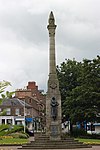
| Wellmeadow Gardens, War Memorial
|
|
|
|
56°35′30″N 3°20′13″W / 56.591692°N 3.337015°W / 56.591692; -3.337015 (Wellmeadow Gardens, War Memorial)
|
Category A
|
22321
|
 Upload another image
|
| Rattray (Old), High Street, Rattray Church Of Scotland Parish Church, Graveyard, Walls, Gatepiers And Gates
|
|
|
|
56°35′46″N 3°19′16″W / 56.596086°N 3.321062°W / 56.596086; -3.321062 (Rattray (Old), High Street, Rattray Church Of Scotland Parish Church, Graveyard, Walls, Gatepiers And Gates)
|
Category C(S)
|
22329
|
Upload Photo
|
| 13, 15 And 15A Allan Street
|
|
|
|
56°35′33″N 3°20′16″W / 56.592366°N 3.337837°W / 56.592366; -3.337837 (13, 15 And 15A Allan Street)
|
Category C(S)
|
49416
|
Upload Photo
|
| Emma Terrace, St Mary's Old Manse Including Ancillary Building, Boundary Walls And Gates
|
|
|
|
56°35′26″N 3°20′50″W / 56.590523°N 3.347135°W / 56.590523; -3.347135 (Emma Terrace, St Mary's Old Manse Including Ancillary Building, Boundary Walls And Gates)
|
Category B
|
49423
|
Upload Photo
|
| Ericht Lane, Police Station Including Boundary Walls, Gatepiers And Railings
|
|
|
|
56°35′30″N 3°20′19″W / 56.591747°N 3.338645°W / 56.591747; -3.338645 (Ericht Lane, Police Station Including Boundary Walls, Gatepiers And Railings)
|
Category C(S)
|
49424
|
Upload Photo
|
| George Street, Wingate And Northneuk Including Boundary Walls, Railings And Gates
|
|
|
|
56°35′27″N 3°20′33″W / 56.590896°N 3.342523°W / 56.590896; -3.342523 (George Street, Wingate And Northneuk Including Boundary Walls, Railings And Gates)
|
Category C(S)
|
49425
|
Upload Photo
|
| 1 High Street
|
|
|
|
56°35′35″N 3°20′21″W / 56.592935°N 3.339225°W / 56.592935; -3.339225 (1 High Street)
|
Category C(S)
|
49426
|
Upload Photo
|
| 3 - 9 (Odd Nos) High Street
|
|
|
|
56°35′34″N 3°20′22″W / 56.592826°N 3.3394°W / 56.592826; -3.3394 (3 - 9 (Odd Nos) High Street)
|
Category C(S)
|
49427
|
Upload Photo
|
| James Street, Blairgowrie Church Of Scotland Parish Church And Church Hall With Boundary Walls, Railings And Gates
|
|
|
|
56°35′36″N 3°20′32″W / 56.593461°N 3.342093°W / 56.593461; -3.342093 (James Street, Blairgowrie Church Of Scotland Parish Church And Church Hall With Boundary Walls, Railings And Gates)
|
Category B
|
49430
|
Upload Photo
|
| Keay Street, Drumsheen Including Gate, Gatepiers And Railings
|
|
|
|
56°35′32″N 3°20′48″W / 56.592218°N 3.346576°W / 56.592218; -3.346576 (Keay Street, Drumsheen Including Gate, Gatepiers And Railings)
|
Category B
|
49433
|
Upload Photo
|
| Lower Mill Street, Riverside Granary
|
|
|
|
56°35′34″N 3°20′13″W / 56.592707°N 3.337067°W / 56.592707; -3.337067 (Lower Mill Street, Riverside Granary)
|
Category C(S)
|
49436
|
Upload Photo
|
| Newton Terrace, Bush House Including Ancillary Building, Boundary Walls And Railings
|
|
|
|
56°35′39″N 3°20′33″W / 56.594149°N 3.342443°W / 56.594149; -3.342443 (Newton Terrace, Bush House Including Ancillary Building, Boundary Walls And Railings)
|
Category C(S)
|
49441
|
Upload Photo
|
| Rattray (New), Mount Ericht Road, Woodville Including Boundary Walls, Gatepiers And Railings
|
|
|
|
56°35′38″N 3°20′04″W / 56.593984°N 3.334409°W / 56.593984; -3.334409 (Rattray (New), Mount Ericht Road, Woodville Including Boundary Walls, Gatepiers And Railings)
|
Category C(S)
|
49473
|
Upload Photo
|
| 13A Wellmeadow
|
|
|
|
56°35′31″N 3°20′13″W / 56.592017°N 3.33688°W / 56.592017; -3.33688 (13A Wellmeadow)
|
Category C(S)
|
49485
|
Upload Photo
|
| Kirk Wynd, Hill Church Including Boundary Walls, Gatepiers And Gates
|
|
|
|
56°35′43″N 3°20′25″W / 56.595225°N 3.340185°W / 56.595225; -3.340185 (Kirk Wynd, Hill Church Including Boundary Walls, Gatepiers And Gates)
|
Category B
|
22288
|
Upload Photo
|
| 31 - 37 (Odd Nos) High Street Former Institute And Library
|
|
|
|
56°35′32″N 3°20′25″W / 56.592233°N 3.340242°W / 56.592233; -3.340242 (31 - 37 (Odd Nos) High Street Former Institute And Library)
|
Category B
|
22296
|
Upload Photo
|
| Brown Street, Old Bank House Including Ancillary Buildings, Gatepiers, Boundary Walls And Railings
|
|
|
|
56°35′34″N 3°20′32″W / 56.592893°N 3.342334°W / 56.592893; -3.342334 (Brown Street, Old Bank House Including Ancillary Buildings, Gatepiers, Boundary Walls And Railings)
|
Category B
|
22304
|
Upload Photo
|
| Rattray (New), Riverside Road, Ericht Bank Including Ancillary Buildings, Boundary Walls And Gatepiers
|
|
|
|
56°35′34″N 3°20′05″W / 56.592885°N 3.334728°W / 56.592885; -3.334728 (Rattray (New), Riverside Road, Ericht Bank Including Ancillary Buildings, Boundary Walls And Gatepiers)
|
Category B
|
22323
|
Upload Photo
|
| Rattray (New), Ashgrove Road, Loon Brae Including Boundary Walls And Gatepiers
|
|
|
|
56°35′32″N 3°19′52″W / 56.592088°N 3.331101°W / 56.592088; -3.331101 (Rattray (New), Ashgrove Road, Loon Brae Including Boundary Walls And Gatepiers)
|
Category B
|
22327
|
Upload Photo
|
| Rattray (Old), High Street, Rattray Church Of Scotland Parish Church
|
|
|
|
56°35′46″N 3°19′16″W / 56.59622°N 3.321067°W / 56.59622; -3.321067 (Rattray (Old), High Street, Rattray Church Of Scotland Parish Church)
|
Category B
|
22328
|
Upload Photo
|
| Rattray (New), Balmoral Road, Linnkeith House (Flats 1 To 4 Inclusive) And Linnkeith Cottage
|
|
|
|
56°35′53″N 3°20′19″W / 56.598135°N 3.338594°W / 56.598135; -3.338594 (Rattray (New), Balmoral Road, Linnkeith House (Flats 1 To 4 Inclusive) And Linnkeith Cottage)
|
Category B
|
22331
|
Upload Photo
|
| Keay Street, The Shieling Including Ancillary Building And Gate
|
|
|
|
56°35′29″N 3°20′35″W / 56.591483°N 3.343065°W / 56.591483; -3.343065 (Keay Street, The Shieling Including Ancillary Building And Gate)
|
Category B
|
48639
|
Upload Photo
|
| Coupar Angus Road, Altamount Lodge
|
|
|
|
56°35′16″N 3°20′12″W / 56.587724°N 3.336777°W / 56.587724; -3.336777 (Coupar Angus Road, Altamount Lodge)
|
Category C(S)
|
49421
|
Upload Photo
|
| 17 And 19 Perth Street, Irvine's Butcher And Knock Ma Har
|
|
|
|
56°35′27″N 3°20′29″W / 56.59081°N 3.341348°W / 56.59081; -3.341348 (17 And 19 Perth Street, Irvine's Butcher And Knock Ma Har)
|
Category C(S)
|
49444
|
Upload Photo
|
| Rattray (New), Ashgrove Road, The Haugh Including Coach House, Garden Store, Boundary Walls And Gatepiers
|
|
|
|
56°35′18″N 3°19′44″W / 56.588429°N 3.32879°W / 56.588429; -3.32879 (Rattray (New), Ashgrove Road, The Haugh Including Coach House, Garden Store, Boundary Walls And Gatepiers)
|
Category C(S)
|
49447
|
Upload Photo
|
| Kirkwynd, Hill Church Graveyard
|
|
|
|
56°35′42″N 3°20′23″W / 56.595079°N 3.339594°W / 56.595079; -3.339594 (Kirkwynd, Hill Church Graveyard)
|
Category B
|
22289
|
Upload Photo
|
| Reform Street, St Mary's South Church (Formerly Church Of Scotland) Including Church Hall
|
|
|
|
56°35′25″N 3°20′19″W / 56.590408°N 3.338598°W / 56.590408; -3.338598 (Reform Street, St Mary's South Church (Formerly Church Of Scotland) Including Church Hall)
|
Category B
|
48970
|
Upload Photo
|
| 14, A, B, C And D Allan Street, Royal Bank Of Scotland
|
|
|
|
56°35′32″N 3°20′18″W / 56.592308°N 3.338274°W / 56.592308; -3.338274 (14, A, B, C And D Allan Street, Royal Bank Of Scotland)
|
Category B
|
49417
|
Upload Photo
|
| Rattray (New), Hatton Road, Buchanan House Including Boundary Walls And Gatepier
|
|
|
|
56°35′53″N 3°20′05″W / 56.597924°N 3.334824°W / 56.597924; -3.334824 (Rattray (New), Hatton Road, Buchanan House Including Boundary Walls And Gatepier)
|
Category C(S)
|
49456
|
Upload Photo
|
| Rattray (New), Hatton Road, The Marfield
|
|
|
|
56°35′52″N 3°19′56″W / 56.597646°N 3.332257°W / 56.597646; -3.332257 (Rattray (New), Hatton Road, The Marfield)
|
Category C(S)
|
49471
|
Upload Photo
|
| Rattray (Old), New Road, Mansefield Including Ancillary Building And Boundary Walls
|
|
|
|
56°35′44″N 3°19′21″W / 56.595656°N 3.322562°W / 56.595656; -3.322562 (Rattray (Old), New Road, Mansefield Including Ancillary Building And Boundary Walls)
|
Category C(S)
|
49475
|
Upload Photo
|
| Tannage Street, Warehouse
|
|
|
|
56°35′29″N 3°20′07″W / 56.591279°N 3.335307°W / 56.591279; -3.335307 (Tannage Street, Warehouse)
|
Category C(S)
|
49480
|
Upload Photo
|
| 21, 22 And 23 Wellmeadow
|
|
|
|
56°35′30″N 3°20′16″W / 56.591801°N 3.337768°W / 56.591801; -3.337768 (21, 22 And 23 Wellmeadow)
|
Category C(S)
|
49488
|
Upload Photo
|
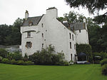
| Newton Street, Newton Castle
|
|
|
|
56°35′31″N 3°21′01″W / 56.592024°N 3.350413°W / 56.592024; -3.350413 (Newton Street, Newton Castle)
|
Category A
|
22314
|
 Upload another image
See more images
|
| 24 And 25 Wellmeadow
|
|
|
|
56°35′30″N 3°20′16″W / 56.591667°N 3.337698°W / 56.591667; -3.337698 (24 And 25 Wellmeadow)
|
Category C(S)
|
22317
|
Upload Photo
|
| Coupar Angus Road, Altamount House Hotel Including Gatepiers, Boundary Walls And Railings
|
|
|
|
56°35′09″N 3°20′11″W / 56.585913°N 3.336371°W / 56.585913; -3.336371 (Coupar Angus Road, Altamount House Hotel Including Gatepiers, Boundary Walls And Railings)
|
Category B
|
22333
|
Upload Photo
|
| Coupar Angus Road, Altamount House Hotel, Courtyard
|
|
|
|
56°35′10″N 3°20′11″W / 56.586172°N 3.336494°W / 56.586172; -3.336494 (Coupar Angus Road, Altamount House Hotel, Courtyard)
|
Category C(S)
|
49419
|
Upload Photo
|
| 39 - 43 (Odd Nos) High Street Including Boundary Wall
|
|
|
|
56°35′32″N 3°20′25″W / 56.592125°N 3.340222°W / 56.592125; -3.340222 (39 - 43 (Odd Nos) High Street Including Boundary Wall)
|
Category C(S)
|
49429
|
Upload Photo
|
| Newton Street, Adylinn Including Boundary Walls, Railings And Gate
|
|
|
|
56°35′26″N 3°20′36″W / 56.590509°N 3.343438°W / 56.590509; -3.343438 (Newton Street, Adylinn Including Boundary Walls, Railings And Gate)
|
Category C(S)
|
49438
|
Upload Photo
|
| Perth Road, Duncraggan
|
|
|
|
56°34′58″N 3°20′44″W / 56.582722°N 3.345636°W / 56.582722; -3.345636 (Perth Road, Duncraggan)
|
Category B
|
49442
|
Upload Photo
|
| Rattray (New), Balmoral Road, Balmoral Hotel
|
|
|
|
56°35′36″N 3°19′57″W / 56.593466°N 3.332485°W / 56.593466; -3.332485 (Rattray (New), Balmoral Road, Balmoral Hotel)
|
Category C(S)
|
49448
|
Upload Photo
|
| Rattray (New), Balmoral Road, Mount Ericht Including Walled Garden, Courtyard With Ancillary Buildings, Boundary Walls, Gatepiers And Gates
|
|
|
|
56°35′35″N 3°19′59″W / 56.593101°N 3.333026°W / 56.593101; -3.333026 (Rattray (New), Balmoral Road, Mount Ericht Including Walled Garden, Courtyard With Ancillary Buildings, Boundary Walls, Gatepiers And Gates)
|
Category C(S)
|
49451
|
Upload Photo
|
| Rattray (New), Braes Road, Croft-Na-Coille Including Boundary Walls And Gatepiers
|
|
|
|
56°35′35″N 3°19′46″W / 56.59296°N 3.329373°W / 56.59296; -3.329373 (Rattray (New), Braes Road, Croft-Na-Coille Including Boundary Walls And Gatepiers)
|
Category C(S)
|
49455
|
Upload Photo
|
| Rattray (New), High Street, Elsham
|
|
|
|
56°35′38″N 3°19′52″W / 56.593875°N 3.331229°W / 56.593875; -3.331229 (Rattray (New), High Street, Elsham)
|
Category C(S)
|
49472
|
Upload Photo
|
| Upper Mill Street, Millbank House Including Boundary Walls
|
|
|
|
56°35′35″N 3°20′17″W / 56.593003°N 3.337957°W / 56.593003; -3.337957 (Upper Mill Street, Millbank House Including Boundary Walls)
|
Category C(S)
|
49483
|
Upload Photo
|
| 17 Wellmeadow, Cartwheel Inn
|
|
|
|
56°35′32″N 3°20′15″W / 56.592091°N 3.337485°W / 56.592091; -3.337485 (17 Wellmeadow, Cartwheel Inn)
|
Category C(S)
|
49487
|
Upload Photo
|
| 1 George Street Including Boundary Walls, Railings And Gate
|
|
|
|
56°35′35″N 3°20′29″W / 56.593048°N 3.341281°W / 56.593048; -3.341281 (1 George Street Including Boundary Walls, Railings And Gate)
|
Category C(S)
|
22299
|
Upload Photo
|
| 5 George Street
|
|
|
|
56°35′35″N 3°20′29″W / 56.593011°N 3.341393°W / 56.593011; -3.341393 (5 George Street)
|
Category C(S)
|
22300
|
Upload Photo
|
| Rattray (Old), Parkhill Road, Old Inn Including Boundary Walls
|
|
|
|
56°35′50″N 3°19′19″W / 56.597208°N 3.321997°W / 56.597208; -3.321997 (Rattray (Old), Parkhill Road, Old Inn Including Boundary Walls)
|
Category B
|
22330
|
Upload Photo
|
| 11 - 15 (Odd Nos) High Street Including Boundary Walls
|
|
|
|
56°35′34″N 3°20′23″W / 56.59277°N 3.339593°W / 56.59277; -3.339593 (11 - 15 (Odd Nos) High Street Including Boundary Walls)
|
Category C(S)
|
49428
|
Upload Photo
|
| James Street, James Street House Including Boundary Walls And Gate
|
|
|
|
56°35′35″N 3°20′25″W / 56.593157°N 3.34034°W / 56.593157; -3.34034 (James Street, James Street House Including Boundary Walls And Gate)
|
Category C(S)
|
49431
|
Upload Photo
|
| Rattray (New), Ashgrove Road, Ericht Lodge Including Boundary Walls And Gate
|
|
|
|
56°35′32″N 3°19′54″W / 56.59226°N 3.331791°W / 56.59226; -3.331791 (Rattray (New), Ashgrove Road, Ericht Lodge Including Boundary Walls And Gate)
|
Category B
|
49446
|
Upload Photo
|
| Rattray (New), Balmoral Road, Hope Park Lodge Including Boundary Walls, Gatepier And Railings
|
|
|
|
56°35′53″N 3°20′14″W / 56.597979°N 3.337269°W / 56.597979; -3.337269 (Rattray (New), Balmoral Road, Hope Park Lodge Including Boundary Walls, Gatepier And Railings)
|
Category C(S)
|
49450
|
Upload Photo
|
| Rattray (New), Balmoral Road, Mount Ericht Lodge Including Boundary Walls, Gatepiers, Gates And Railings
|
|
|
|
56°35′37″N 3°19′58″W / 56.593536°N 3.332667°W / 56.593536; -3.332667 (Rattray (New), Balmoral Road, Mount Ericht Lodge Including Boundary Walls, Gatepiers, Gates And Railings)
|
Category C(S)
|
49452
|
Upload Photo
|
| Rattray (New), Hatton Road, The Alders Including Boundary Walls
|
|
|
|
56°35′51″N 3°20′04″W / 56.597604°N 3.33452°W / 56.597604; -3.33452 (Rattray (New), Hatton Road, The Alders Including Boundary Walls)
|
Category C(S)
|
49470
|
Upload Photo
|
| 13 Wellmeadow, The Ericht Ale House
|
|
|
|
56°35′31″N 3°20′12″W / 56.592019°N 3.336733°W / 56.592019; -3.336733 (13 Wellmeadow, The Ericht Ale House)
|
Category C(S)
|
49484
|
Upload Photo
|
| William Street, Ywca
|
|
|
|
56°35′25″N 3°20′25″W / 56.590221°N 3.340155°W / 56.590221; -3.340155 (William Street, Ywca)
|
Category C(S)
|
49490
|
Upload Photo
|
| 21 High Street And 1 - 7 (Odd Nos) Brown Street Including Railings
|
|
|
|
56°35′33″N 3°20′23″W / 56.592542°N 3.33983°W / 56.592542; -3.33983 (21 High Street And 1 - 7 (Odd Nos) Brown Street Including Railings)
|
Category B
|
22294
|
Upload Photo
|
| George Street, St Catharine's Episcopal Church Including Boundary Walls, Railings And Gate
|
|
|
|
56°35′34″N 3°20′28″W / 56.592853°N 3.341013°W / 56.592853; -3.341013 (George Street, St Catharine's Episcopal Church Including Boundary Walls, Railings And Gate)
|
Category B
|
22297
|
Upload Photo
|
| 13A And 15 James Street
|
|
|
|
56°35′36″N 3°20′28″W / 56.593213°N 3.34101°W / 56.593213; -3.34101 (13A And 15 James Street)
|
Category C(S)
|
22298
|
Upload Photo
|
| 7, 9 And 11 Allan Street, Old Brewery Building
|
|
|
|
56°35′32″N 3°20′16″W / 56.592242°N 3.337734°W / 56.592242; -3.337734 (7, 9 And 11 Allan Street, Old Brewery Building)
|
Category B
|
22322
|
Upload Photo
|
| Rattray (New), Boat Brae, Riverside Methodist Church Including Church Hall, Boundary Walls, Railings And Gates
|
|
|
|
56°35′33″N 3°20′05″W / 56.592634°N 3.334622°W / 56.592634; -3.334622 (Rattray (New), Boat Brae, Riverside Methodist Church Including Church Hall, Boundary Walls, Railings And Gates)
|
Category B
|
22324
|
Upload Photo
|
| Rattray (New), Balmoral Road, Keathbank Mill
|
|
|
|
56°36′00″N 3°20′27″W / 56.600034°N 3.340812°W / 56.600034; -3.340812 (Rattray (New), Balmoral Road, Keathbank Mill)
|
Category A
|
22332
|
Upload Photo
|
| 1, 3 And 5 Allan Street
|
|
|
|
56°35′32″N 3°20′15″W / 56.59218°N 3.337618°W / 56.59218; -3.337618 (1, 3 And 5 Allan Street)
|
Category C(S)
|
49415
|
Upload Photo
|
| Coupar Angus Road, Altamount House Hotel, Walled Garden
|
|
|
|
56°35′11″N 3°20′14″W / 56.586263°N 3.33723°W / 56.586263; -3.33723 (Coupar Angus Road, Altamount House Hotel, Walled Garden)
|
Category C(S)
|
49420
|
Upload Photo
|
| Lochy Terrace, Greenfield Including Boundary Walls, Railings, Gatepiers And Gates
|
|
|
|
56°35′31″N 3°20′40″W / 56.591937°N 3.344335°W / 56.591937; -3.344335 (Lochy Terrace, Greenfield Including Boundary Walls, Railings, Gatepiers And Gates)
|
Category C(S)
|
49434
|
Upload Photo
|
| Lochy Terrace, The Cedars Including Ancillary Building, Boundary Walls And Railings
|
|
|
|
56°35′26″N 3°20′44″W / 56.590566°N 3.345622°W / 56.590566; -3.345622 (Lochy Terrace, The Cedars Including Ancillary Building, Boundary Walls And Railings)
|
Category C(S)
|
49435
|
Upload Photo
|
| Rattray (New), Balmoral Road, Hope Park Trust-Smith Bequest, Hope Park House Including Walled Garden. Boundary Walls, Gatepiers And Railings
|
|
|
|
56°35′57″N 3°20′13″W / 56.599176°N 3.337035°W / 56.599176; -3.337035 (Rattray (New), Balmoral Road, Hope Park Trust-Smith Bequest, Hope Park House Including Walled Garden. Boundary Walls, Gatepiers And Railings)
|
Category B
|
49449
|
Upload Photo
|
| Rattray (New), Balmoral Road, Parish Church Hall Including Boundary Walls With Inset Railings And Gates
|
|
|
|
56°35′39″N 3°20′02″W / 56.594169°N 3.333943°W / 56.594169; -3.333943 (Rattray (New), Balmoral Road, Parish Church Hall Including Boundary Walls With Inset Railings And Gates)
|
Category C(S)
|
49453
|
Upload Photo
|
| Rattray (Old), Rosebank Road, Viewlands Including Ancillary Building, Boundary Walls And Gatepiers
|
|
|
|
56°35′42″N 3°19′20″W / 56.595032°N 3.322101°W / 56.595032; -3.322101 (Rattray (Old), Rosebank Road, Viewlands Including Ancillary Building, Boundary Walls And Gatepiers)
|
Category C(S)
|
49476
|
Upload Photo
|
| Upper Allan Street, Hill Primary School Including Ancillary Buildings,
|
|
|
|
56°35′38″N 3°20′29″W / 56.593757°N 3.341355°W / 56.593757; -3.341355 (Upper Allan Street, Hill Primary School Including Ancillary Buildings,)
|
Category B
|
49482
|
Upload Photo
|
| 14 Wellmeadow
|
|
|
|
56°35′32″N 3°20′14″W / 56.592085°N 3.337289°W / 56.592085; -3.337289 (14 Wellmeadow)
|
Category B
|
49486
|
Upload Photo
|