182:
291:
181:
259:
188:
208:
140:
83:
276:
30:
271:
Belgian heritage register: Direction générale opérationnelle - Aménagement du territoire, Logement, Patrimoine et
Energie (DG4)
241:
173:
116:
296:
25:
21:
272:
285:
185:
Kerk Saint-Pierre en ensemble van de genoemde kerk, het kerkhof met zijn ommuring
127:
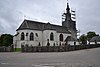
Church of Saint-Pierre and ensemble of the church, the cemetery and its walls
223:
210:
155:
142:
98:
85:
180:
292:
Lists of protected heritage sites in
Luxembourg (Belgium)
260:
List of protected heritage sites in
Luxembourg (Belgium)
8:
35:
193:
125:
67:
7:
69:Rural Buildings, currently a farm
14:
29:. This list is part of Belgium's
1:
78:Remagne, Rue du Centre n° 6
313:
22:protected heritage sites
239:84077-CLT-0003-01
171:84077-CLT-0002-01
114:84077-CLT-0001-01
224:49.891428°N 5.314607°E
186:
156:49.903668°N 5.388001°E
99:49.976462°N 5.493443°E
184:
24:in the Walloon town
18:This table shows an
229:49.891428; 5.314607
220: /
201:Libramont-Chevigny
161:49.903668; 5.388001
152: /
133:Libramont-Chevigny
104:49.976462; 5.493443
95: /
75:Libramont-Chevigny
297:Libramont-Chevigny
187:
26:Libramont-Chevigny
251:
250:
244:
195:Ponds of Luchy
176:
119:
31:national heritage
304:
240:
235:
234:
232:
231:
230:
225:
221:
218:
217:
216:
213:
172:
167:
166:
164:
163:
162:
157:
153:
150:
149:
148:
145:
115:
110:
109:
107:
106:
105:
100:
96:
93:
92:
91:
88:
36:
20:overview of the
312:
311:
307:
306:
305:
303:
302:
301:
282:
281:
268:
256:
228:
226:
222:
219:
214:
211:
209:
207:
206:
196:
160:
158:
154:
151:
146:
143:
141:
139:
138:
128:
103:
101:
97:
94:
89:
86:
84:
82:
81:
70:
64:
60:
56:
52:
48:
44:
40:
12:
11:
5:
310:
308:
300:
299:
294:
284:
283:
280:
279:
274:
267:
264:
263:
262:
255:
252:
249:
248:
246:
236:
204:
202:
199:
197:
192:
191:
178:
168:
136:
134:
131:
129:
124:
123:
121:
111:
79:
76:
73:
71:
66:
65:
61:
57:
53:
49:
45:
43:Year/architect
41:
13:
10:
9:
6:
4:
3:
2:
309:
298:
295:
293:
290:
289:
287:
278:
277:www.dglive.be
275:
273:
270:
269:
265:
261:
258:
257:
253:
247:
245:
243:
237:
233:
205:
203:
200:
198:
194:
190:
183:
179:
177:
175:
169:
165:
137:
135:
132:
130:
126:
122:
120:
118:
112:
108:
80:
77:
74:
72:
68:
62:
58:
54:
50:
46:
42:
38:
37:
34:
32:
28:
27:
23:
16:
238:
170:
113:
47:Town/section
19:
17:
15:
227: /
189:More images
159: /
102: /
55:Coordinates
286:Categories
266:References
212:49°53′29″N
144:49°54′13″N
87:49°58′35″N
215:5°18′53″E
147:5°23′17″E
90:5°29′36″E
254:See also
59:Number
51:Address
39:Object
63:Image
242:Info
174:Info
117:Info
288::
33:.
Text is available under the Creative Commons Attribution-ShareAlike License. Additional terms may apply.