516:
52:
321:
36:
59:
512:
Little Grass Valley Dam is a rock-fill dam 840 feet (260 m) long and 210 feet (64 m) high, with 18 feet (5.5 m) of freeboard. The South
Feather Water and Power Agency owns the dam.
540:, managed by the Feather River Ranger District. The area supports boating, camping, fishing, swimming, picnicking, horseback riding, mountain biking, wildlife viewing, and hiking.
94:
755:
770:
765:
561:
615:
351:
51:
658:
606:
760:
611:
17:
515:
552:. The Pacific Crest Trail passes north of the lake and can be reached by way of the Bald Mountain Trail from Horse Camp.
566:
339:
259:
80:
576:
417:
297:
157:
601:
529:
263:
549:
150:
533:
267:
138:
665:
717:
246:
693:
485:
174:
164:
664:. California Department of Water Resources, Division of Safety of Dams. Archived from
749:
126:
145:
South Fork
Feather River, Black Rock Creek, Ice Creek, Pancake Ravine, Kenzie Ravine
571:
320:
35:
366:
353:
109:
96:
131:
139:
151:
16:
This article is about the lake. For the census-designated place, see
514:
659:"Dams Within the Jurisdiction of the State of California (H-M)"
718:"Plumas National Forest - Little Grass Valley Recreation Area"
404:
737:
536:, Little Grass Valley Reservoir is the centerpiece of the
58:
502:
494:
484:
476:
468:
463:
455:
447:
439:
431:
423:
413:
403:
398:
390:
382:
345:
335:
327:
313:
236:
228:
220:
212:
204:
196:
188:
184:
173:
163:
149:
137:
125:
86:
76:
28:
277:(National ID CA00269), which was completed in 1961
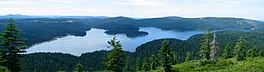
40:The reservoir in 2004, viewed from Bald Mountain.
87:
548:By car, the lake is about ninety minutes from
8:
319:
310:
25:
562:List of dams and reservoirs in California
688:
686:
616:United States Department of the Interior
756:Reservoirs in Plumas County, California
588:
653:
651:
649:
647:
645:
596:
594:
592:
23:Reservoir in Plumas County, California
771:Artificial lakes of the United States
694:"Little Grass Valley Recreation Area"
643:
641:
639:
637:
635:
633:
631:
629:
627:
625:
480:93,010 acre-feet (114,730,000 m)
224:93,010 acre-feet (114,730,000 m)
7:
459:834,000 cubic yards (638,000 m)
394:South Feather Water and Power Agency
607:Geographic Names Information System
538:Little Grass Valley Recreation Area
273:The lake's waters are impounded by
14:
766:Reservoirs in Northern California
308:Dam in Plumas County, California
57:
50:
34:
612:United States Geological Survey
602:"Little Grass Valley Reservoir"
235:
227:
219:
211:
203:
195:
187:
18:Little Grass Valley, California
490:25.9 square miles (67 km)
169:25.9 square miles (67 km)
1:
472:Little Grass Valley Reservoir
296:The lake discharges into the
256:Little Grass Valley Reservoir
75:
65:Little Grass Valley Reservoir
29:Little Grass Valley Reservoir
440:Elevation at crest
567:List of lakes in California
787:
247:not a well-defined measure
15:
443:5,052 feet (1,540 m)
340:Plumas County, California
318:
260:Plumas County, California
258:is an artificial lake in
244:
240:5,036 feet (1,535 m)
232:14.5 miles (23.3 km)
208:1,433 acres (580 ha)
81:Plumas County, California
45:
33:
761:Reservoirs in California
577:Grass Valley, California
418:South Fork Feather River
298:South Fork Feather River
279: (63 years ago)
158:South Fork Feather River
314:Little Grass Valley Dam
304:Little Grass Valley Dam
275:Little Grass Valley Dam
530:Plumas National Forest
520:
367:39.72167°N 121.02278°W
264:Plumas National Forest
110:39.72917°N 120.99028°W
518:
498:2 miles (3.2 km)
435:840 feet (260 m)
405:Type of dam
192:2 miles (3.2 km)
506:1 mile (1.6 km)
451:30 feet (9.1 m)
427:210 feet (64 m)
372:39.72167; -121.02278
200:1 mile (1.6 km)
115:39.72917; -120.99028
671:on December 6, 2012
534:Pacific Crest Trail
495:Maximum length
486:Catchment area
477:Total capacity
363: /
268:Pacific Crest Trail
216:65 feet (20 m)
106: /
521:
503:Maximum width
448:Width (crest)
510:
509:
399:Dam and spillways
383:Opening date
253:
252:
237:Surface elevation
778:
740:
735:
729:
728:
726:
724:
714:
708:
707:
705:
703:
698:
690:
681:
680:
678:
676:
670:
663:
655:
620:
619:
598:
378:
377:
375:
374:
373:
368:
364:
361:
360:
359:
356:
323:
311:
287:
285:
280:
245:Shore length is
153:
152:Primary outflows
141:
121:
120:
118:
117:
116:
111:
107:
104:
103:
102:
99:
89:
61:
60:
54:
38:
26:
786:
785:
781:
780:
779:
777:
776:
775:
746:
745:
744:
743:
736:
732:
722:
720:
716:
715:
711:
701:
699:
696:
692:
691:
684:
674:
672:
668:
661:
657:
656:
623:
600:
599:
590:
585:
558:
546:
526:
456:Dam volume
371:
369:
365:
362:
357:
354:
352:
350:
349:
309:
306:
294:
283:
281:
278:
177: countries
140:Primary inflows
114:
112:
108:
105:
100:
97:
95:
93:
92:
72:
71:
70:
69:
68:
67:
66:
62:
41:
24:
21:
12:
11:
5:
784:
782:
774:
773:
768:
763:
758:
748:
747:
742:
741:
730:
709:
682:
621:
587:
586:
584:
581:
580:
579:
574:
569:
564:
557:
554:
545:
542:
525:
522:
508:
507:
504:
500:
499:
496:
492:
491:
488:
482:
481:
478:
474:
473:
470:
466:
465:
461:
460:
457:
453:
452:
449:
445:
444:
441:
437:
436:
433:
429:
428:
425:
421:
420:
415:
411:
410:
407:
401:
400:
396:
395:
392:
388:
387:
384:
380:
379:
347:
343:
342:
337:
333:
332:
329:
325:
324:
316:
315:
307:
305:
302:
293:
290:
251:
250:
242:
241:
238:
234:
233:
230:
226:
225:
222:
218:
217:
214:
210:
209:
206:
202:
201:
198:
194:
193:
190:
186:
185:
182:
181:
178:
171:
170:
167:
165:Catchment area
161:
160:
155:
147:
146:
143:
135:
134:
129:
123:
122:
90:
84:
83:
78:
74:
73:
64:
63:
56:
55:
49:
48:
47:
46:
43:
42:
39:
31:
30:
22:
13:
10:
9:
6:
4:
3:
2:
783:
772:
769:
767:
764:
762:
759:
757:
754:
753:
751:
739:
734:
731:
719:
713:
710:
695:
689:
687:
683:
667:
660:
654:
652:
650:
648:
646:
644:
642:
640:
638:
636:
634:
632:
630:
628:
626:
622:
617:
613:
609:
608:
603:
597:
595:
593:
589:
582:
578:
575:
573:
570:
568:
565:
563:
560:
559:
555:
553:
551:
543:
541:
539:
535:
531:
523:
517:
513:
505:
501:
497:
493:
489:
487:
483:
479:
475:
471:
467:
462:
458:
454:
450:
446:
442:
438:
434:
430:
426:
422:
419:
416:
412:
408:
406:
402:
397:
393:
389:
385:
381:
376:
348:
344:
341:
338:
334:
331:United States
330:
326:
322:
317:
312:
303:
301:
299:
291:
289:
276:
271:
269:
265:
261:
257:
248:
243:
239:
231:
223:
215:
213:Average depth
207:
199:
191:
183:
180:United States
179:
176:
172:
168:
166:
162:
159:
156:
154:
148:
144:
142:
136:
133:
130:
128:
124:
119:
91:
85:
82:
79:
53:
44:
37:
32:
27:
19:
733:
723:December 21,
721:. Retrieved
712:
702:December 21,
700:. Retrieved
675:December 21,
673:. Retrieved
666:the original
605:
572:Grass valley
547:
537:
527:
511:
295:
274:
272:
255:
254:
229:Shore length
221:Water volume
205:Surface area
738:Google maps
528:Located in
370: /
358:121°01′22″W
346:Coordinates
189:Max. length
113: /
101:120°59′25″W
88:Coordinates
750:Categories
583:References
524:Recreation
355:39°43′18″N
197:Max. width
98:39°43′45″N
550:Yuba City
532:near the
464:Reservoir
292:Hydrology
266:near the
132:reservoir
556:See also
414:Impounds
409:Rockfill
391:Owner(s)
336:Location
77:Location
469:Creates
328:Country
282: (
544:Access
432:Length
424:Height
697:(PDF)
669:(PDF)
662:(PDF)
175:Basin
725:2012
704:2012
677:2012
519:Lake
386:1961
284:1961
262:and
127:Type
752::
685:^
624:^
614:,
610:.
604:.
591:^
300:.
288:.
270:.
727:.
706:.
679:.
618:.
286:)
249:.
20:.
Text is available under the Creative Commons Attribution-ShareAlike License. Additional terms may apply.