42:
29:
49:
513:
210:
The boundaries of the grasslands on certain maps can be misleading. Within the boundaries of the national grassland are significant portions of state-owned and privately owned land, much of it leased by cattle ranchers for grazing. Overall, in descending order of land area, it is located in parts of
271:
The ongoing oil and gas exploration, extraction, and distribution in the region has the potential for long term negative impacts on the soil, water, vegetation, and wildlife of the grassland, including threatened and endangered species.
1181:
1413:
1403:
1398:
1369:
551:
230:
Private land intersperses the public grassland acres and there is heavy cattle grazing throughout with 253 allotments in the Medora district and more than 190 in the
Mckenzie district.
590:
1408:
1174:
651:
603:
1388:
1167:
187:(and therefore not included in the preceding statistics). The Little Missouri National Grassland was once a part of the Custer National Forest, but is now a part of the
91:
41:
598:
1423:
1362:
544:
1393:
1147:
821:
572:
1428:
517:
1078:
1355:
921:
711:
706:
671:
537:
320:
969:
911:
901:
1119:
1109:
881:
866:
831:
796:
751:
721:
691:
686:
661:
1114:
1033:
896:
861:
766:
716:
1266:
916:
856:
851:
841:
836:
801:
786:
741:
731:
701:
676:
621:
560:
234:
1418:
1129:
1124:
906:
876:
871:
826:
776:
761:
726:
696:
666:
311:
1303:
1271:
926:
816:
811:
806:
781:
771:
756:
746:
656:
641:
631:
224:
891:
886:
736:
681:
464:
385:
1317:
1296:
1236:
1190:
1018:
636:
580:
180:
1211:
1201:
791:
646:
626:
316:
1286:
1251:
1246:
1221:
1206:
944:
846:
987:
216:
212:
192:
142:
1291:
1231:
1226:
959:
1083:
1003:
265:
238:
220:
344:
1281:
1276:
1241:
1073:
1068:
1058:
1053:
949:
249:
188:
1256:
1216:
613:
306:
1093:
261:
1088:
1048:
1038:
253:
977:
184:
28:
428:"Studying the Effects of Land Use on Sediment Loads, Little Missouri National Grasslands, North Dakota"
1063:
1043:
257:
242:
79:
1008:
982:
489:. Fort Collins, CO: U.S. Department of Agriculture, Forest Service, Rocky Mountain Research Station
936:
241:, North Dakota's highest point, is located in the extreme southeast corner, south of the town of
196:
164:
481:
480:
Butler, Jack L.; Ott, Jacqueline P.; Hartway, Cynthia R.; Dickerson, Brian E. (November 2018).
456:
450:
377:
371:
460:
381:
1339:
1159:
152:
483:
Biological
Assessment of Oil and Gas Development on the Little Missouri National Grassland
427:
1382:
172:
69:
175:. At 1,028,051 acres (416,037 ha), it is the largest grassland in the country.
564:
281:
168:
65:
529:
376:. Nebraska: The Ronald K. and Judith M. Stolz Parks Publishing Fund. pp.
286:
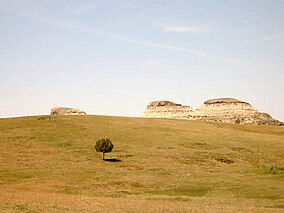
203:, a rugged terrain extensively eroded by wind and water. It is a mixed-grass
106:
93:
512:
455:. Nebraska: Ronald K. and Judith M. Stolz Parks Publishing Fund. pp.
200:
348:
204:
176:
452:
The
National Grasslands - A guide to America's Undiscovered Treasures
373:
The
National Grasslands - A guide to America's Undiscovered Treasures
199:. A predominant feature of the grassland is colorful and beautiful
248:
The grassland is administered by the Forest
Service as part of the
1163:
533:
523:
1338:
This article related to a protected area in North Dakota is a
404:
48:
1343:
1414:
Protected areas of Golden Valley County, North Dakota
1102:
1026:
1017:
996:
968:
935:
612:
589:
571:
347:. U.S. Forest Service. January 2013. Archived from
148:
138:
130:
122:
85:
75:
61:
21:
1404:Protected areas of Billings County, North Dakota
1399:Protected areas of McKenzie County, North Dakota
1409:Protected areas of Slope County, North Dakota
1363:
1175:
545:
8:
1148:North Dakota Parks and Recreation Department
207:, meaning it has both long and short grass.
1370:
1356:
1182:
1168:
1160:
1023:
552:
538:
530:
345:"Land Areas of the National Forest System"
18:
1389:National grasslands of the United States
1191:National Grasslands of the United States
321:United States Department of the Interior
16:Protected grassland in North Dakota, USA
902:White Horse Hill National Game Preserve
298:
399:
397:
339:
337:
7:
1424:Little Missouri River (North Dakota)
1335:
1333:
307:"Little Missouri National Grassland"
60:
1394:Protected areas established in 1960
312:Geographic Names Information System
237:meanders through the grassland and
1342:. You can help Knowledge (XXG) by
1304:Midewin National Tallgrass Prairie
518:Little Missouri National Grassland
161:Little Missouri National Grassland
153:Little Missouri National Grassland
126:1,028,784 acres (4,163.34 km)
22:Little Missouri National Grassland
14:
1429:North Dakota protected area stubs
511:
181:Theodore Roosevelt National Park
47:
40:
27:
317:United States Geological Survey
129:
74:
1:
195:unit consisting entirely of
604:Knife River Indian Villages
405:"Dakota Prairie Grasslands"
1445:
1419:Grasslands of North Dakota
1332:
1004:International Peace Garden
183:, which is managed by the
1312:
1197:
1142:
614:National Wildlife Refuges
524:Dakota Prairie Grasslands
250:Dakota Prairie Grasslands
189:Dakota Prairie Grasslands
35:
26:
599:Fort Union Trading Post
591:National Historic Sites
449:Moul, Francis (2006).
370:Moul, Francis (2006).
254:Bismarck, North Dakota
179:within its borders is
970:U.S. Wilderness Areas
526:- U.S. Forest Service
407:. U.S. Forest Service
235:Little Missouri River
185:National Park Service
1044:Fort Abraham Lincoln
520:at Wikimedia Commons
426:Macek-Rowland, K.M.
260:district offices in
80:Medora, North Dakota
1009:North Country Trail
937:National Grasslands
822:School Section Lake
351:on December 1, 2012
197:National Grasslands
167:located in western
143:U.S. Forest Service
139:Governing body
103: /
1318:Full Detailed List
988:Theodore Roosevelt
581:Theodore Roosevelt
256:. There are local
165:National Grassland
107:47.099°N 103.537°W
1351:
1350:
1327:
1326:
1267:Lyndon B. Johnson
1157:
1156:
1138:
1137:
516:Media related to
158:
157:
76:Nearest city
1436:
1372:
1365:
1358:
1334:
1184:
1177:
1170:
1161:
1120:Little Metigoshe
1110:Butte Saint Paul
1103:Recreation areas
1024:
554:
547:
540:
531:
515:
499:
498:
496:
494:
488:
477:
471:
470:
446:
440:
439:
437:
435:
423:
417:
416:
414:
412:
401:
392:
391:
367:
361:
360:
358:
356:
341:
332:
331:
329:
327:
303:
252:from offices in
118:
117:
115:
114:
113:
112:47.099; -103.537
108:
104:
101:
100:
99:
96:
51:
50:
44:
31:
19:
1444:
1443:
1439:
1438:
1437:
1435:
1434:
1433:
1379:
1378:
1377:
1376:
1330:
1328:
1323:
1308:
1272:McClellan Creek
1262:Little Missouri
1193:
1188:
1158:
1153:
1134:
1115:Crow Flies High
1098:
1084:Little Missouri
1079:Lewis and Clark
1013:
992:
964:
955:Little Missouri
931:
922:Wintering River
712:J. Clark Salyer
707:Hutchinson Lake
672:Cottonwood Lake
608:
585:
567:
561:Protected areas
558:
508:
503:
502:
492:
490:
486:
479:
478:
474:
467:
448:
447:
443:
433:
431:
425:
424:
420:
410:
408:
403:
402:
395:
388:
369:
368:
364:
354:
352:
343:
342:
335:
325:
323:
305:
304:
300:
295:
278:
193:National Forest
111:
109:
105:
102:
97:
94:
92:
90:
89:
57:
56:
55:
54:
53:
52:
17:
12:
11:
5:
1442:
1440:
1432:
1431:
1426:
1421:
1416:
1411:
1406:
1401:
1396:
1391:
1381:
1380:
1375:
1374:
1367:
1360:
1352:
1349:
1348:
1325:
1324:
1322:
1321:
1313:
1310:
1309:
1307:
1306:
1300:
1299:
1294:
1289:
1284:
1279:
1274:
1269:
1264:
1259:
1254:
1249:
1244:
1239:
1234:
1229:
1224:
1219:
1214:
1209:
1204:
1198:
1195:
1194:
1189:
1187:
1186:
1179:
1172:
1164:
1155:
1154:
1152:
1151:
1143:
1140:
1139:
1136:
1135:
1133:
1132:
1127:
1122:
1117:
1112:
1106:
1104:
1100:
1099:
1097:
1096:
1091:
1086:
1081:
1076:
1074:Lake Sakakawea
1071:
1069:Lake Metigoshe
1066:
1061:
1059:Grahams Island
1056:
1054:Fort Stevenson
1051:
1046:
1041:
1036:
1030:
1028:
1021:
1015:
1014:
1012:
1011:
1006:
1000:
998:
994:
993:
991:
990:
985:
980:
974:
972:
966:
965:
963:
962:
957:
952:
950:Dakota Prairie
947:
941:
939:
933:
932:
930:
929:
924:
919:
914:
909:
904:
899:
894:
889:
884:
879:
874:
869:
864:
859:
854:
849:
844:
839:
834:
829:
824:
819:
814:
809:
804:
799:
794:
789:
784:
779:
774:
769:
764:
759:
754:
749:
744:
739:
734:
729:
724:
719:
714:
709:
704:
699:
694:
689:
684:
679:
674:
669:
664:
659:
654:
649:
644:
639:
634:
629:
624:
618:
616:
610:
609:
607:
606:
601:
595:
593:
587:
586:
584:
583:
577:
575:
573:National Parks
569:
568:
559:
557:
556:
549:
542:
534:
528:
527:
521:
507:
506:External links
504:
501:
500:
472:
465:
441:
418:
393:
386:
362:
333:
297:
296:
294:
291:
290:
289:
284:
277:
274:
156:
155:
150:
146:
145:
140:
136:
135:
132:
128:
127:
124:
120:
119:
87:
83:
82:
77:
73:
72:
63:
59:
58:
46:
45:
39:
38:
37:
36:
33:
32:
24:
23:
15:
13:
10:
9:
6:
4:
3:
2:
1441:
1430:
1427:
1425:
1422:
1420:
1417:
1415:
1412:
1410:
1407:
1405:
1402:
1400:
1397:
1395:
1392:
1390:
1387:
1386:
1384:
1373:
1368:
1366:
1361:
1359:
1354:
1353:
1347:
1345:
1341:
1336:
1331:
1320:
1319:
1315:
1314:
1311:
1305:
1302:
1301:
1298:
1297:Thunder Basin
1295:
1293:
1290:
1288:
1285:
1283:
1280:
1278:
1275:
1273:
1270:
1268:
1265:
1263:
1260:
1258:
1255:
1253:
1250:
1248:
1245:
1243:
1240:
1238:
1237:Crooked River
1235:
1233:
1230:
1228:
1225:
1223:
1220:
1218:
1215:
1213:
1210:
1208:
1205:
1203:
1200:
1199:
1196:
1192:
1185:
1180:
1178:
1173:
1171:
1166:
1165:
1162:
1150:
1149:
1145:
1144:
1141:
1131:
1130:Pembina Gorge
1128:
1126:
1125:Pelican Point
1123:
1121:
1118:
1116:
1113:
1111:
1108:
1107:
1105:
1101:
1095:
1092:
1090:
1087:
1085:
1082:
1080:
1077:
1075:
1072:
1070:
1067:
1065:
1062:
1060:
1057:
1055:
1052:
1050:
1047:
1045:
1042:
1040:
1037:
1035:
1032:
1031:
1029:
1025:
1022:
1020:
1016:
1010:
1007:
1005:
1002:
1001:
999:
997:Other Federal
995:
989:
986:
984:
981:
979:
976:
975:
973:
971:
967:
961:
958:
956:
953:
951:
948:
946:
943:
942:
940:
938:
934:
928:
925:
923:
920:
918:
915:
913:
910:
908:
905:
903:
900:
898:
895:
893:
890:
888:
885:
883:
882:Sunburst Lake
880:
878:
875:
873:
870:
868:
867:Stoney Slough
865:
863:
860:
858:
855:
853:
850:
848:
845:
843:
840:
838:
835:
833:
832:Sheyenne Lake
830:
828:
825:
823:
820:
818:
815:
813:
810:
808:
805:
803:
800:
798:
797:Pleasant Lake
795:
793:
790:
788:
785:
783:
780:
778:
775:
773:
770:
768:
765:
763:
760:
758:
755:
753:
752:Lake Patricia
750:
748:
745:
743:
740:
738:
735:
733:
730:
728:
725:
723:
722:Kellys Slough
720:
718:
715:
713:
710:
708:
705:
703:
700:
698:
695:
693:
692:Half-Way Lake
690:
688:
687:Florence Lake
685:
683:
680:
678:
675:
673:
670:
668:
665:
663:
662:Canfield Lake
660:
658:
655:
653:
650:
648:
645:
643:
640:
638:
635:
633:
630:
628:
625:
623:
620:
619:
617:
615:
611:
605:
602:
600:
597:
596:
594:
592:
588:
582:
579:
578:
576:
574:
570:
566:
562:
555:
550:
548:
543:
541:
536:
535:
532:
525:
522:
519:
514:
510:
509:
505:
485:
484:
476:
473:
468:
466:9780803283206
462:
458:
454:
453:
445:
442:
429:
422:
419:
406:
400:
398:
394:
389:
387:9780803283206
383:
379:
375:
374:
366:
363:
350:
346:
340:
338:
334:
322:
318:
314:
313:
308:
302:
299:
292:
288:
285:
283:
280:
279:
275:
273:
269:
267:
263:
259:
255:
251:
246:
244:
240:
236:
231:
228:
226:
225:Golden Valley
222:
218:
214:
208:
206:
202:
198:
194:
190:
186:
182:
178:
174:
173:United States
170:
166:
162:
154:
151:
147:
144:
141:
137:
134:June 23, 1960
133:
125:
121:
116:
88:
84:
81:
78:
71:
70:United States
67:
64:
43:
34:
30:
25:
20:
1344:expanding it
1337:
1329:
1316:
1261:
1212:Butte Valley
1202:Black Kettle
1146:
1094:Turtle River
954:
897:Upper Souris
862:Stewart Lake
767:Little Goose
717:Johnson Lake
652:Buffalo Lake
565:North Dakota
491:. Retrieved
482:
475:
451:
444:
432:. Retrieved
421:
409:. Retrieved
372:
365:
353:. Retrieved
349:the original
324:. Retrieved
310:
301:
282:Initial Rock
270:
266:Watford City
247:
232:
229:
209:
169:North Dakota
160:
159:
66:North Dakota
1287:Rita Blanca
1252:Grand River
1247:Fort Pierre
1222:Cedar River
1207:Buffalo Gap
1089:Sully Creek
1049:Fort Ransom
1039:Cross Ranch
1034:Beaver Lake
945:Cedar River
917:Willow Lake
857:Springwater
852:Snyder Lake
842:Silver Lake
837:Sibley Lake
802:Pretty Rock
787:Maple River
742:Lake Nettie
732:Lake George
702:Hobart Lake
677:Dakota Lake
622:Appert Lake
434:December 9,
411:December 9,
355:December 9,
326:December 9,
239:White Butte
131:Established
110: /
98:103°32′13″W
86:Coordinates
1383:Categories
978:Chase Lake
907:White Lake
877:Stump Lake
872:Storm Lake
827:Shell Lake
777:Lords Lake
762:Lambs Lake
727:Lake Alice
697:Hiddenwood
667:Chase Lake
493:2 December
293:References
287:Yule Ranch
227:counties.
95:47°05′56″N
1064:Icelandic
927:Wood Lake
912:Wild Rice
817:Rose Lake
812:Rock Lake
807:Rabb Lake
782:Lost Lake
772:Long Lake
757:Lake Zahl
747:Lake Otis
657:Camp Lake
642:Bone Hill
632:Arrowwood
262:Dickinson
1292:Sheyenne
1232:Comanche
1227:Cimarron
983:Lostwood
960:Sheyenne
892:Tomahawk
887:Tewaukon
737:Lake Ilo
682:Des Lacs
276:See also
217:Billings
213:McKenzie
201:badlands
177:Enclaved
62:Location
637:Audubon
205:prairie
149:Website
1282:Pawnee
1277:Oglala
1242:Curlew
792:McLean
647:Brumba
627:Ardoch
463:
430:. USGS
384:
258:ranger
243:Amidon
223:, and
1257:Kiowa
1217:Caddo
1027:Parks
1019:State
847:Slade
487:(PDF)
221:Slope
163:is a
1340:stub
495:2018
461:ISBN
436:2012
413:2012
382:ISBN
357:2012
328:2012
264:and
233:The
191:, a
123:Area
563:of
1385::
459:.
457:70
396:^
380:.
378:67
336:^
319:,
315:.
309:.
268:.
245:.
219:,
215:,
171:,
68:,
1371:e
1364:t
1357:v
1346:.
1183:e
1176:t
1169:v
553:e
546:t
539:v
497:.
469:.
438:.
415:.
390:.
359:.
330:.
Text is available under the Creative Commons Attribution-ShareAlike License. Additional terms may apply.