386:
47:
398:
374:
362:
293:
235:
31:
350:
286:, was pursuing a number of agricultural improvements on his extensive estates. Intensive drainage work may have taken place in the 1740s as part of the improvements undertaken to provide employment for Irish Montgomerie estate workers during the Irish potato famines of the 1740s and the mid 19th centuries. Many drainage schemes also date to the end of World War I when many soldiers returned en masse to civilian life.
300:
54:
246:
shows the loch as a substantial oval shaped body of water with an outflow via the Red Burn. Direct rainfall and runoff were the main inflows. Roy's map of 1747-55 clearly marks the loch, although much reduced in extent. A Loch Wards habitation is marked in the vicinity of the old loch.
250:
Littlestane Farm, recorded as 'Litle Stain' is marked as being on the northern end of
Littlestane Loch in the 1600s, however by the 1750s the farmstead was no longer on its edge due to its contraction. Related placenames on Pont's map are 'Lichmil' or Loch Mill and 'Thurland' or
276:. The Perceton Branch of the Glasgow and South Western Railway ran across the site, as does the A736 Lochlibo Road. A mineral line is shown in 1910 running to Fergushill Collieries numbers 29 and 30, the railway embankment being built across the loch bed.
373:
264:
In 1845 the loch was used for a curling match between
Dundonald and a Monkton and Prestwick team. Dundonald won by 91 shots with 32 players on each team. The loch was recorded as Sourley Loch.
261:
The old Irvine Burgh boundary is marked on OS maps as running up the Red Burn, then following the curve of the old
Littlestane lochshore before extending through the old Sourlie Woods site.
349:
272:
The outflow of this shallow loch was into the Red Burn, which now is now piped in the vicinity of the loch and downstream only flows in a canalised form, diverted in places, into the
385:
361:
279:
As stated, the loch shrunk between 1600 and the 1750s, existing only as marshy areas on the first OS maps of the 1850s and not featuring on maps of the early 1800s.
258:
Ordnance Survey maps of the 19th century show the loch site as a marshy area extending into the
Sourlie Woods and as an area of marshy land close to Lawthorn Wood.
46:
283:
397:
218:
Sourlie Nature
Reserve. The loch was natural, sitting in a hollow created by glaciation. The loch waters outflow was via the Red Burn that flows into the
94:
292:
575:
313:
570:
531:
516:
501:
178:
222:. The site of Littlestane Loch site is partly built over and much of the site is now public open space lying within the Parish of
580:
560:
585:
451:
343:
at NS 329 404, was a favourite haunt of Robert Burns and his friend
Richard Brown whilst the two were in Irvine in 1781 - 82.
379:
The 1960s bridge abutment at the site of the old
Drukken Steps with the old Toll Road route in the background.
215:
207:
191:
565:
336:
234:
151:
355:
The site of the
Drukken Steps over the Red Burn on the 1774 Toll road to Millburn via Higgens House.
139:
527:
512:
497:
30:
211:
163:
79:
554:
332:
273:
219:
126:
214:, Scotland. It is nowadays (2011) only visible as an area of permanent water in the
328:
243:
340:
223:
203:
75:
545:
427:
109:
96:
524:
Tolls and
Tacksmen. 18th century Roads in the County of John Loudoun McAdam
252:
140:
152:
367:
Littlestane
Farmhouse, now the manse for Girdle Toll Parish Church.
233:
132:
282:
The loch's drainage may have begun in the 18th century when
242:
Blaeu's map of 1654, derived from the early 1600s survey by
526:. Ayrshire Monographs No. 13. Ayr Arch & Nat Hist Soc.
439:
391:
The site of the Drukken Steps and the canalised Red Burn.
317:
Previous location of Littlestane Loch, North Ayrshire
187:
177:
173:
162:
150:
138:
125:
86:
71:
23:
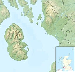
202:, was situated in the mid-Ayrshire clayland near
87:
8:
284:Alexander Montgomerie, 10th Earl of Eglinton
331:is the existence of the nearby site of the
20:
238:Sourlie pond on the site of the old loch.
299:
53:
417:
345:
403:The Red Burn near The Hill Roundabout.
7:
494:Ayrshire : Discovering a County
423:
421:
14:
546:Video footage of Littlestane Loch
396:
384:
372:
360:
348:
298:
291:
268:The draining of Littlestane Loch
52:
45:
29:
16:Former lake in Irvine, Scotland
511:. Glasgow : Neil Wilson.
496:. Ayr : Fort Publishing.
1:
335:over the Red Burn in the old
70:
576:Freshwater lochs of Scotland
462:MacIntosh, Pages 37 & 39
146:Rainfall, springs and runoff
35:The site of Littlestane Loch
442:Retrieved : 2011-01-25
430:Retrieved : 2011-01-25
602:
507:MacIntosh, Donald (2006).
571:History of North Ayrshire
452:Historical Curling Places
40:
28:
581:Lakes of North Ayrshire
561:Lochs of North Ayrshire
216:Scottish Wildlife Trust
586:Irvine, North Ayrshire
522:McLure, David (1994).
239:
110:55.634028°N 4.638778°W
237:
314:class=notpageimage|
115:55.634028; -4.638778
509:Travels in Galloway
492:Love, Dane (2003).
131:Drained freshwater
106: /
327:A minor link with
240:
323:The Drukken Steps
197:
196:
593:
481:
480:McClure, page 61
478:
472:
469:
463:
460:
454:
449:
443:
437:
431:
425:
400:
388:
376:
364:
352:
306:Littlestane Loch
302:
301:
295:
200:Littlestane Loch
154:
153:Primary outflows
142:
121:
120:
118:
117:
116:
111:
107:
104:
103:
102:
99:
89:
60:Littlestane Loch
56:
55:
49:
33:
24:Littlestane Loch
21:
601:
600:
596:
595:
594:
592:
591:
590:
551:
550:
542:
537:
485:
484:
479:
475:
470:
466:
461:
457:
450:
446:
438:
434:
426:
419:
411:
404:
401:
392:
389:
380:
377:
368:
365:
356:
353:
325:
320:
319:
318:
316:
310:
309:
308:
307:
303:
270:
232:
166: countries
141:Primary inflows
114:
112:
108:
105:
100:
97:
95:
93:
92:
67:
66:
65:
64:
63:
62:
61:
57:
36:
17:
12:
11:
5:
599:
597:
589:
588:
583:
578:
573:
568:
563:
553:
552:
549:
548:
541:
540:External links
538:
536:
535:
520:
505:
489:
483:
482:
473:
471:Love, page 60.
464:
455:
444:
432:
416:
415:
410:
407:
406:
405:
402:
395:
393:
390:
383:
381:
378:
371:
369:
366:
359:
357:
354:
347:
337:Eglinton Woods
324:
321:
312:
311:
305:
304:
297:
296:
290:
289:
288:
269:
266:
231:
228:
212:North Ayrshire
195:
194:
189:
185:
184:
181:
175:
174:
171:
170:
167:
160:
159:
156:
148:
147:
144:
136:
135:
129:
123:
122:
90:
84:
83:
80:North Ayrshire
73:
69:
68:
59:
58:
51:
50:
44:
43:
42:
41:
38:
37:
34:
26:
25:
15:
13:
10:
9:
6:
4:
3:
2:
598:
587:
584:
582:
579:
577:
574:
572:
569:
567:
564:
562:
559:
558:
556:
547:
544:
543:
539:
533:
532:0-9502698-5-9
529:
525:
521:
518:
517:1-897784-92-9
514:
510:
506:
503:
502:0-9544461-1-9
499:
495:
491:
490:
488:
477:
474:
468:
465:
459:
456:
453:
448:
445:
441:
436:
433:
429:
424:
422:
418:
414:
408:
399:
394:
387:
382:
375:
370:
363:
358:
351:
346:
344:
342:
338:
334:
333:Drukken Steps
330:
322:
315:
294:
287:
285:
280:
277:
275:
274:River Garnock
267:
265:
262:
259:
256:
254:
248:
245:
236:
229:
227:
225:
221:
220:River Garnock
217:
213:
209:
205:
201:
193:
190:
186:
182:
180:
176:
172:
168:
165:
161:
157:
155:
149:
145:
143:
137:
134:
130:
128:
124:
119:
91:
85:
81:
77:
74:
48:
39:
32:
27:
22:
19:
566:Former lochs
523:
508:
493:
486:
476:
467:
458:
447:
435:
412:
329:Robert Burns
326:
281:
278:
271:
263:
260:
257:
249:
244:Timothy Pont
241:
199:
198:
18:
428:Blaeu's Map
341:Stanecastle
224:Girdle Toll
204:Stanecastle
188:Settlements
113: /
101:4°38′19.6″W
98:55°38′2.5″N
88:Coordinates
76:Stanecastle
555:Categories
409:References
82:, Scotland
487:Sources;
440:Roy's Map
169:Scotland
158:Red Burn
72:Location
413:Notes;
253:Thirled
230:History
179:Islands
530:
515:
500:
255:land.
208:Irvine
192:Irvine
339:near
164:Basin
528:ISBN
513:ISBN
498:ISBN
183:None
133:loch
127:Type
557::
420:^
226:.
210:,
206:,
78:,
534:.
519:.
504:.
Text is available under the Creative Commons Attribution-ShareAlike License. Additional terms may apply.