352:
340:
65:
479:
72:
45:
160:
312:
style. It has a number of interesting 18th-century memorials. There are also several examples of "Brute angels", carved by an 18th-century local family of stonemasons named Brute, inside and outside the church. A large hollow
325:. It has a 14th-century bell tower with a peal of six bells, which are rung to mark notable events. A church is documented here in 1060, but this may have been an earlier building of which no trace now remains.
351:
184:
317:
in the churchyard is reputed to be about 3,000 years old. The church is one of three in the Vale of Gwryne parish, in the St Catwg
Ministry Area, together with
177:
226:
520:
339:
172:
208:
544:
132:
549:
64:
513:
539:
114:
96:
50:
146:
506:
218:
213:
189:
165:
287:
428:
490:
429:"Llanbedr, St Peter's Church, History & Visiting Information | Historic Wales Guide"
291:
446:
263:
104:
478:
533:
314:
309:
279:
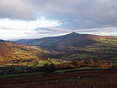
17:
467:
290:
range. The village lies within the shadow of Table
Mountain, an outlying spur of
283:
275:
375:
Ordnance Survey
Explorer map OL13 'Brecon Beacons National Park: eastern area'
302:
241:
228:
318:
298:
385:
322:
295:
44:
403:
486:
271:
267:
138:
122:
85:
328:
The village pub, located opposite the church, is the Red Lion.
468:
images of
Llanbedr and surrounding area on Geograph website
308:
The church of St Peter is a 14th-15th-century church in
494:
183:
171:
159:
145:
131:
113:
95:
37:
514:
8:
521:
507:
34:
368:
335:
278:. It lies above the river known as the
262:is a small village in the community of
154:
130:
94:
41:
182:
170:
158:
144:
112:
7:
475:
473:
282:just above its confluence with the
274:, 2 miles (3 km) northeast of
493:. You can help Knowledge (XXG) by
25:
49:Llanbedr from the west, with the
477:
350:
338:
71:
70:
63:
43:
286:in the southern reaches of the
1:
404:"St Peter's Church, Llanbedr"
566:
472:
199:
195:
155:
58:
42:
32:Human settlement in Wales
294:on which is perched the
27:Village in Powys, Wales
545:Black Mountains, Wales
489:location article is a
390:St Catwg Ministry Area
550:Powys geography stubs
18:Llanbedr, Crickhowell
447:"Red Lion, Llanbedr"
147:Sovereign state
266:, in the county of
238: /
115:Principal area
345:St. Peter's Church
242:51.8768°N 3.1062°W
178:Mid and West Wales
540:Villages in Powys
502:
501:
257:
256:
53:in the background
16:(Redirected from
557:
523:
516:
509:
481:
474:
455:
454:
451:CAMRA Experience
443:
437:
436:
425:
419:
418:
416:
414:
400:
394:
393:
382:
376:
373:
354:
342:
292:Pen Cerrig-calch
253:
252:
250:
249:
248:
247:51.8768; -3.1062
243:
239:
236:
235:
234:
231:
205:
141:
84:Location within
74:
73:
67:
47:
35:
21:
565:
564:
560:
559:
558:
556:
555:
554:
530:
529:
528:
527:
464:
459:
458:
445:
444:
440:
433:Britain Express
427:
426:
422:
412:
410:
402:
401:
397:
384:
383:
379:
374:
370:
365:
358:
355:
346:
343:
334:
288:Black Mountains
264:Vale of Grwyney
246:
244:
240:
237:
232:
229:
227:
225:
224:
223:
203:
137:
127:
109:
105:Vale of Grwyney
91:
90:
89:
88:
82:
81:
80:
79:
75:
54:
33:
28:
23:
22:
15:
12:
11:
5:
563:
561:
553:
552:
547:
542:
532:
531:
526:
525:
518:
511:
503:
500:
499:
482:
471:
470:
463:
462:External links
460:
457:
456:
438:
420:
395:
377:
367:
366:
364:
361:
360:
359:
356:
349:
347:
344:
337:
333:
330:
255:
254:
222:
221:
216:
211:
206:
204:List of places
200:
197:
196:
193:
192:
187:
181:
180:
175:
169:
168:
163:
157:
156:
153:
152:
151:United Kingdom
149:
143:
142:
135:
129:
128:
126:
125:
119:
117:
111:
110:
108:
107:
101:
99:
93:
92:
83:
77:
76:
69:
68:
62:
61:
60:
59:
56:
55:
48:
40:
39:
31:
26:
24:
14:
13:
10:
9:
6:
4:
3:
2:
562:
551:
548:
546:
543:
541:
538:
537:
535:
524:
519:
517:
512:
510:
505:
504:
498:
496:
492:
488:
483:
480:
476:
469:
466:
465:
461:
452:
448:
442:
439:
434:
430:
424:
421:
409:
405:
399:
396:
391:
387:
381:
378:
372:
369:
362:
353:
348:
341:
336:
331:
329:
326:
324:
320:
316:
311:
310:Perpendicular
306:
304:
300:
297:
293:
289:
285:
281:
280:Grwyne Fechan
277:
273:
269:
265:
261:
251:
220:
217:
215:
212:
210:
207:
202:
201:
198:
194:
191:
188:
186:
179:
176:
174:
167:
164:
162:
150:
148:
140:
136:
134:
124:
121:
120:
118:
116:
106:
103:
102:
100:
98:
87:
66:
57:
52:
46:
36:
30:
19:
495:expanding it
484:
450:
441:
432:
423:
411:. Retrieved
407:
398:
389:
380:
371:
357:The Red Lion
327:
307:
259:
258:
29:
413:7 September
284:Grwyne Fawr
276:Crickhowell
245: /
166:Dyfed-Powys
534:Categories
386:"Llanbedr"
363:References
303:Crug Hywel
230:51°52′36″N
51:Sugar Loaf
319:Llangenny
299:hill fort
233:3°06′22″W
185:Ambulance
97:Community
323:Patricio
315:yew tree
296:Iron Age
260:Llanbedr
78:Llanbedr
38:Llanbedr
332:Gallery
133:Country
408:Mysite
161:Police
487:Powys
485:This
272:Wales
268:Powys
219:Powys
214:Wales
190:Welsh
139:Wales
123:Powys
86:Powys
491:stub
415:2024
321:and
173:Fire
301:of
536::
449:.
431:.
406:.
388:.
305:.
270:,
209:UK
522:e
515:t
508:v
497:.
453:.
435:.
417:.
392:.
20:)
Text is available under the Creative Commons Attribution-ShareAlike License. Additional terms may apply.