451:
29:
209:, at an elevation about 3,900 m asl. Along its first 36 km, the river flows southeast and then slowly begins to turn towards the west. In its descent to the lower elevations of the valley, the river starts to run through a canyon carved by the same river in
262:, among other pollutants, which restricts the agricultural activities that can be developed along the river banks. The river water is used only for irrigation of pastureland and crops which tolerate poor water quality, such as onions and potatoes.
224:, about 70 km from the sea, appear the first farms, whose foods are of a great importance for the consume of local people. Finally, the river empties into Pacific Ocean at an extensive beach, just a few kilometers north of
348:
341:
231:
The hydrologic regime of the river basin is rain-dominated. The increase of its water volume occurs mainly in
January and February, as a consequence of the phenomenon known as
334:
484:
242:, the Lluta River would have become the northern border of Chile, and Bolivia would control the narrow strip between the river and the southern border of Peru.
523:
450:
361:
158:
528:
435:
286:
239:
405:
415:
232:
410:
400:
440:
170:
220:, the river turns directly west and just past the canyon terminus, the river begins to widen. In
465:
326:
470:
390:
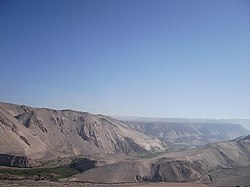
375:
282:
430:
395:
250:
Apart from its problems of salinity and acidity, the river has very elevated levels of
182:
34:
517:
178:
103:
225:
186:
425:
420:
385:
357:
307:
88:
499:
486:
322:(1º edición, Santiago de Chile: Instituto Geográfico Militar ed.).
311:
259:
255:
202:
28:
251:
166:
162:
50:
210:
174:
330:
458:
368:
137:
129:
117:
109:
97:
87:
73:
65:
56:
46:
41:
21:
238:Under the Chilean proposal of 1975 to resolve the
165:. Its headwaters are on the western flanks of the
157:is a river located in the northern portion of the
173:, just a few kilometers south of the border with
197:The Lluta originates at the confluence of the
342:
8:
320:Geografía de Chile — Tomo VIII: Hidrografía
349:
335:
327:
318:Niemeyer, Hans; Cereceda, Pilar (1983).
271:
185:, about 4 km north of the city of
277:
275:
18:
213:and other sediments scarcely joined.
121:3,400 km (1,300 sq mi)
7:
201:(which rises from the slopes of the
524:Rivers of Arica y Parinacota Region
143:2.3 m/s (81 cu ft/s)
306:This article draws heavily on the
14:
449:
312:Spanish-language Knowledge (XXG)
27:
1:
79:3,900 m (12,800 ft)
57:Physical characteristics
75: • elevation
99: • location
545:
314:, accessed March 31, 2007.
139: • average
33:Lluta Valley as seen from
447:
362:Arica y Parinacota Region
159:Arica y Parinacota Region
147:
125:
83:
61:
26:
113:147 km (91 mi)
177:, and empties into the
287:NASA Earth Observatory
240:Atacama border dispute
500:18.41528°S 70.32639°W
308:corresponding article
505:-18.41528; -70.32639
283:"Lluta River, Chile"
496: /
216:In the vicinity of
199:Quebrada Caracarani
171:Parinacota Province
181:at the village of
479:
478:
289:. 2 November 2013
205:volcano) and the
151:
150:
536:
511:
510:
508:
507:
506:
501:
497:
494:
493:
492:
489:
453:
351:
344:
337:
328:
323:
299:
298:
296:
294:
279:
140:
76:
31:
19:
544:
543:
539:
538:
537:
535:
534:
533:
529:Rivers of Chile
514:
513:
504:
502:
498:
495:
490:
487:
485:
483:
482:
480:
475:
471:Cotacotani Lake
454:
445:
364:
355:
317:
303:
302:
292:
290:
281:
280:
273:
268:
248:
233:Bolivian Winter
195:
138:
100:
74:
37:
17:
12:
11:
5:
542:
540:
532:
531:
526:
516:
515:
477:
476:
474:
473:
468:
462:
460:
456:
455:
448:
446:
444:
443:
438:
433:
431:Canal Uchusuma
428:
423:
418:
413:
408:
403:
398:
393:
388:
383:
378:
372:
370:
366:
365:
356:
354:
353:
346:
339:
331:
325:
324:
315:
301:
300:
270:
269:
267:
264:
247:
244:
211:rhyolite tuffs
194:
191:
183:Villa Frontera
149:
148:
145:
144:
141:
135:
134:
131:
127:
126:
123:
122:
119:
115:
114:
111:
107:
106:
101:
98:
95:
94:
91:
85:
84:
81:
80:
77:
71:
70:
67:
63:
62:
59:
58:
54:
53:
48:
44:
43:
39:
38:
35:Chile Route 11
32:
24:
23:
16:River in Chile
15:
13:
10:
9:
6:
4:
3:
2:
541:
530:
527:
525:
522:
521:
519:
512:
509:
472:
469:
467:
466:Chungará Lake
464:
463:
461:
457:
452:
442:
439:
437:
434:
432:
429:
427:
424:
422:
419:
417:
414:
412:
409:
407:
404:
402:
399:
397:
394:
392:
389:
387:
384:
382:
379:
377:
374:
373:
371:
367:
363:
359:
352:
347:
345:
340:
338:
333:
332:
329:
321:
316:
313:
309:
305:
304:
288:
284:
278:
276:
272:
265:
263:
261:
257:
253:
246:Water quality
245:
243:
241:
236:
234:
229:
227:
223:
219:
214:
212:
208:
204:
200:
192:
190:
188:
184:
180:
179:Pacific Ocean
176:
172:
168:
164:
160:
156:
146:
142:
136:
132:
128:
124:
120:
116:
112:
108:
105:
104:Pacific Ocean
102:
96:
92:
90:
86:
82:
78:
72:
68:
64:
60:
55:
52:
49:
45:
40:
36:
30:
25:
20:
481:
380:
319:
291:. Retrieved
249:
237:
230:
221:
217:
215:
207:Azufre River
206:
198:
196:
154:
152:
503: /
426:Canal Mauri
421:Canal Lauca
358:Hydrography
293:February 6,
155:Lluta River
22:Lluta River
518:Categories
491:70°19′35″W
488:18°24′55″S
266:References
118:Basin size
416:Viscacham
391:Camarones
376:Cosapilla
130:Discharge
436:San José
411:Tignamar
401:Rivilcar
396:Uchusuma
222:Chironta
218:Socoroma
42:Location
441:Atajama
310:in the
260:sulfate
256:arsenic
169:of the
47:Country
369:Rivers
258:, and
203:Tacora
193:Course
133:
110:Length
93:
69:
66:Source
459:Lakes
386:Lauca
381:Lluta
252:boron
226:Arica
187:Arica
167:Andes
163:Chile
89:Mouth
51:Chile
406:Seco
295:2014
175:Peru
153:The
360:of
161:of
520::
285:.
274:^
254:,
235:.
228:.
189:.
350:e
343:t
336:v
297:.
Text is available under the Creative Commons Attribution-ShareAlike License. Additional terms may apply.