58:
1003:
1345:
42:
198:
65:
206:
341:
At the end of World War 2, there was a large beach
Minefield at Rattray. During land mine clearance, high pressure water pumps were used at the Loch of Strathbeg to provide a supply of water to jetting nozzles used to wash out land mines from the sand dunes. This work was carried out by 11th Coy
260:
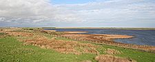
where there is a car park at the edge of the reserve. There is also the 'Starnafin Centre' from which visitors may also watch the birds from and find out more information about which birds and animals are present locally.
1369:
1394:
410:
385:
683:
894:
1166:
330:
In 1943, Loch of
Strathbeg was used by the Luftwaffe as an area to drop supplies to spies in the area. The area to the North of the loch was normally the drop point.
318:(approx. 2 metres). This does not necessarily correspond with conditions today, as the same source also notes that the nearby beach head was at the time saturated and
497:
1374:
57:
272:
The loch is a very recent creation of geological times, forming naturally in a massive storm in 1720. The lagoon, where the loch is now, its small harbour
887:
1379:
1175:
104:
1240:
769:
634:
592:
561:
530:
502:
445:
1220:
880:
1159:
567:
342:
Bomb disposal led by Major W.M. Hewitt. During clearance into 1946, a number of Royal
Engineer personnel were killed in the minefield.
653:
The loch pre-WWII, the remains of the Castle of
Rattray can be seen to the south and the remains of Lonmay Castle to the north-east.
1389:
807:
256:
and around the loch there are three hides from which visitors may watch the birds and other wildlife. Access to the loch is through
1384:
1152:
333:
One drop in 1943 was set up by the
British to use a double agent to drop a radio, money and some sabotage equipment in a case.
629:
549:
Showing the Loch in the form that it is today but with a small area of water to the west coming from the south of the loch
389:
419:
394:
580:
The Loch, in the approximate shape of today (as the previous map) but missing the small body of water to the south-west
440:
556:
525:
1290:
1108:
640:
464:
Shows the Loch almost completely sealed off, which just a small channel leading into the sea from the south side
661:
1200:
350:
Historical maps of the area are available online that show the transition of
Strathbeg Bay into Loch Strathbeg
264:
The RSPB has recorded over 260 species of bird, 280 species of insect and 26 species of mammal at the reserve.
872:
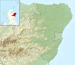
587:
230:
1123:
620:
234:
322:
indeed it says that the loch had dropped at least 4 feet (1.2 m) since 1817, only 37 years earlier.
942:
922:
490:
Shows the sand bar beginning to form from the north and the Loch's shaping is beginning to take place
867:
773:
745:
1062:
952:
598:
837:
477:
290:
mapping of the Loch shows four streams ("burns" in Scots) and one exit point into the north sea.
1133:
1093:
1088:
1002:
803:
721:
164:
1310:
1190:
1067:
414:
257:
227:
historically "Strathbeg Water"; "Water of
Strathbeg"; "Rattray Water" or "Water of Rattray"
1399:
1349:
688:
666:
507:
A new and correct map of
Scotland or North Britain (Northern section); by Robert Campbell
287:
831:
536:
148:
276:
and the village of
Rattray, were cut off from the sea and engulfed by shifting sands.
1363:
1325:
1275:
1250:
908:
451:
242:
86:
656:
1285:
1260:
1128:
1098:
967:
301:
1295:
1270:
1255:
1225:
1195:
1032:
1022:
992:
937:
862:
41:
1265:
1245:
1103:
1072:
1017:
932:
197:
17:
119:
106:
1215:
1144:
1118:
1052:
1042:
1037:
982:
972:
467:
1330:
1315:
1300:
1210:
1179:
1057:
987:
977:
962:
947:
246:
90:
830:
Society for the
Benefit of the Sons and Daughters of the Clergy (1854).
957:
927:
612:
238:
286:
There is another stream, the "Burn o’ Rattra" flowing into the loch.
205:
1320:
1230:
1047:
904:
616:
857:
281:"the outlet of the stream called the burn of Strathbeg into the sea"
1305:
1235:
1027:
716:
472:
352:(links are provided rather than the image for copyright reasons):
1205:
611:
Shows the Loch in the 20th century, much as now, in relation to
253:
210:
141:
136:
1148:
876:
1370:
Royal Society for the Protection of Birds reserves in Scotland
518:
Showing the name "Loch Strathbeg" and the outline of the loch
233:
for wildlife conservation purposes. It is located near to
310:
were to be found in the Parish of Crimond and to have an
1395:
Sites of Special Scientific Interest in Banff and Buchan
680:
Link to the Ordnance Survey website with current map.
825:
823:
821:
819:
1081:
1010:
915:
179:
171:
162:
158:
147:
135:
96:
82:
34:
279:A historical account says that the storm blocked
382:Shows the loch more like a lake than an estuary
97:
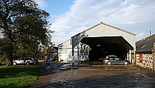
1089:Aden Country Park/Aberdeenshire Farming Museum
793:
791:
283:after which it flowed directly into the loch.
1160:
888:
8:
625:(NB. you will need to zoom in on this image)
583:(NB. you will need to zoom in on this image)
552:(NB. you will need to zoom in on this image)
521:(NB. you will need to zoom in on this image)
493:(NB. you will need to zoom in on this image)
436:(NB. you will need to zoom in on this image)
316:"its greatest depth does not exceed 6½ feet"
1167:
1153:
1145:
895:
881:
873:
31:
764:
762:
355:
204:
196:
833:The New Statistical Account of Scotland
708:
903:Settlements and places of interest in
635:David Rumsey Historical Map Collection
593:David Rumsey Historical Map Collection
562:David Rumsey Historical Map Collection
531:David Rumsey Historical Map Collection
503:David Rumsey Historical Map Collection
446:David Rumsey Historical Map Collection
213:Starnafin visitors centre for the loch
64:
178:
170:
161:
7:
1375:Special Protection Areas in Scotland
568:Alexander Keith Johnston (1804-1871)
433:The estuary with no Loch yet forming
863:Special Protection Area designation
298:In 1854 the loch was estimated at
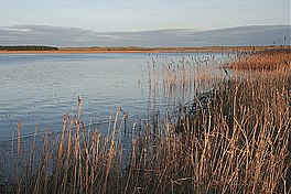
46:Looking south-east across the loch
25:
836:. W. Blackwood and Sons. p.
1380:Protected areas of Aberdeenshire
1343:
1001:
312:"average depth is about 3½ feet"
63:
56:
40:
29:Loch in Aberdeenshire, Scotland
868:RSPB webpage on Loch Strathbeg
252:The loch is maintained by the
1:
746:"About the Loch of Strathbeg"
639:Scotland - northern section;
81:
693:Ordnance Survey "Get-a-map"
420:National Library of Scotland
395:National Library of Scotland
770:"Rattray Head Travel Guide"
450:Scotland or N. Britain; by
1416:
772:. World 66. Archived from
641:John Bartholomew & Co.
1339:
1291:Lochs of Spiggie and Brow
1186:
1109:Formartine and Buchan Way
999:
858:Official Tourism Web Site
800:The Bard O' Buchan Vol 1'
724:Sites Information Service
390:map description on nls.uk
308:"more than three-fourths"
306:(2.9 km² ) of which
191:
187:
51:
39:
1390:Ramsar sites in Scotland
1201:Balranald Nature Reserve
1119:Maritime Heritage Museum
566:Composite: Scotland; by
535:Composite: Scotland; by
231:Special Protection Area
1385:Lochs of Aberdeenshire
798:Stanley Bruce (2005).
214:
202:
120:57.619806°N 1.876943°W
314:(approx. 1.1 metres)
208:
200:
776:on 27 September 2007
630:from DavidRumsey.com
599:Letts, Son & Co.
588:from DavidRumsey.com
557:from DavidRumsey.com
526:from DavidRumsey.com
498:from DavidRumsey.com
441:from DavidRumsey.com
201:View across the loch
125:57.619806; -1.876943
1350:Scotland portal
916:Primary settlements
717:"Loch of Strathbeg"
116: /
1082:Places of interest
657:from NPEmap.org.uk
473:the Scran database
229:) is a designated
215:
203:
180:Reference no.
1357:
1356:
1281:Loch of Strathbeg
1142:
1141:
1114:Loch of Strathbeg
1094:Bullers of Buchan
1011:Other settlements
700:
699:
219:Loch of Strathbeg
195:
194:
16:(Redirected from
1407:
1348:
1347:
1346:
1311:Mull of Galloway
1191:Abernethy Forest
1169:
1162:
1155:
1146:
1068:Stirling Village
1005:
897:
890:
883:
874:
845:
844:
827:
814:
813:
795:
786:
785:
783:
781:
766:
757:
756:
754:
752:
741:
735:
734:
732:
730:
713:
468:from Scran.ac.uk
356:
258:Crimond airfield
175:27 November 1995
131:
130:
128:
127:
126:
121:
117:
114:
113:
112:
109:
99:
67:
66:
60:
44:
32:
21:
1415:
1414:
1410:
1409:
1408:
1406:
1405:
1404:
1360:
1359:
1358:
1353:
1344:
1342:
1335:
1241:Forsinard Flows
1182:
1173:
1143:
1138:
1077:
1006:
997:
911:
901:
854:
849:
848:
829:
828:
817:
810:
797:
796:
789:
779:
777:
768:
767:
760:
750:
748:
743:
742:
738:
728:
726:
715:
714:
710:
705:
689:Ordnance Survey
667:Ordnance Survey
623:
597:Scotland 2; by
581:
550:
519:
491:
434:
411:zoomed in image
368:Map Collection
348:
339:
328:
296:
288:Ordnance Survey
270:
221:(also known as
167:
151: countries
124:
122:
118:
115:
110:
107:
105:
103:
102:
78:
77:
76:
75:
74:
73:
72:
68:
47:
30:
23:
22:
15:
12:
11:
5:
1413:
1411:
1403:
1402:
1397:
1392:
1387:
1382:
1377:
1372:
1362:
1361:
1355:
1354:
1340:
1337:
1336:
1334:
1333:
1328:
1323:
1318:
1313:
1308:
1303:
1298:
1293:
1288:
1283:
1278:
1273:
1268:
1263:
1258:
1253:
1248:
1243:
1238:
1233:
1228:
1223:
1218:
1213:
1208:
1203:
1198:
1193:
1187:
1184:
1183:
1174:
1172:
1171:
1164:
1157:
1149:
1140:
1139:
1137:
1136:
1131:
1126:
1121:
1116:
1111:
1106:
1101:
1096:
1091:
1085:
1083:
1079:
1078:
1076:
1075:
1070:
1065:
1060:
1055:
1050:
1045:
1040:
1035:
1030:
1025:
1020:
1014:
1012:
1008:
1007:
1000:
998:
996:
995:
990:
985:
980:
975:
970:
965:
960:
955:
950:
945:
940:
935:
930:
925:
919:
917:
913:
912:
902:
900:
899:
892:
885:
877:
871:
870:
865:
860:
853:
852:External links
850:
847:
846:
815:
808:
802:. Bard Books.
787:
758:
736:
707:
706:
704:
701:
698:
697:
694:
691:
686:
684:from Bing Maps
681:
678:
674:
673:
670:
664:
659:
654:
651:
647:
646:
643:
637:
632:
627:
609:
605:
604:
601:
595:
590:
585:
578:
574:
573:
570:
564:
559:
554:
547:
543:
542:
539:
537:John Pinkerton
533:
528:
523:
516:
512:
511:
508:
505:
500:
495:
488:
484:
483:
480:
475:
470:
465:
462:
458:
457:
454:
448:
443:
438:
431:
427:
426:
424:
422:
417:
415:page on nls.uk
408:
406:
402:
401:
399:
397:
392:
383:
380:
376:
375:
372:
369:
366:
363:
360:
347:
344:
338:
335:
327:
324:
320:"oozing water"
295:
292:
269:
266:
223:Loch Strathbeg
193:
192:
189:
188:
185:
184:
181:
177:
176:
173:
169:
168:
165:Ramsar Wetland
163:
160:
159:
156:
155:
154:United Kingdom
152:
145:
144:
139:
133:
132:
100:
94:
93:
84:
80:
79:
71:Loch Strathbeg
70:
69:
62:
61:
55:
54:
53:
52:
49:
48:
45:
37:
36:
35:Loch Strathbeg
28:
24:
18:Loch Strathbeg
14:
13:
10:
9:
6:
4:
3:
2:
1412:
1401:
1398:
1396:
1393:
1391:
1388:
1386:
1383:
1381:
1378:
1376:
1373:
1371:
1368:
1367:
1365:
1352:
1351:
1338:
1332:
1329:
1327:
1326:Sumburgh Head
1324:
1322:
1319:
1317:
1314:
1312:
1309:
1307:
1304:
1302:
1299:
1297:
1294:
1292:
1289:
1287:
1284:
1282:
1279:
1277:
1276:Loch Gruinart
1274:
1272:
1269:
1267:
1264:
1262:
1259:
1257:
1254:
1252:
1251:Glenborrodale
1249:
1247:
1244:
1242:
1239:
1237:
1234:
1232:
1229:
1227:
1224:
1222:
1219:
1217:
1214:
1212:
1209:
1207:
1204:
1202:
1199:
1197:
1194:
1192:
1189:
1188:
1185:
1181:
1177:
1170:
1165:
1163:
1158:
1156:
1151:
1150:
1147:
1135:
1134:Slains Castle
1132:
1130:
1127:
1125:
1122:
1120:
1117:
1115:
1112:
1110:
1107:
1105:
1102:
1100:
1097:
1095:
1092:
1090:
1087:
1086:
1084:
1080:
1074:
1071:
1069:
1066:
1064:
1061:
1059:
1056:
1054:
1051:
1049:
1046:
1044:
1041:
1039:
1036:
1034:
1031:
1029:
1026:
1024:
1021:
1019:
1016:
1015:
1013:
1009:
1004:
994:
991:
989:
986:
984:
981:
979:
976:
974:
971:
969:
966:
964:
961:
959:
956:
954:
951:
949:
946:
944:
941:
939:
936:
934:
931:
929:
926:
924:
921:
920:
918:
914:
910:
909:Aberdeenshire
906:
898:
893:
891:
886:
884:
879:
878:
875:
869:
866:
864:
861:
859:
856:
855:
851:
843:
839:
835:
834:
826:
824:
822:
820:
816:
811:
809:0-9547960-2-0
805:
801:
794:
792:
788:
775:
771:
765:
763:
759:
747:
740:
737:
725:
723:
718:
712:
709:
702:
695:
692:
690:
687:
685:
682:
679:
676:
675:
671:
669:, Sheet 031P
668:
665:
663:
660:
658:
655:
652:
649:
648:
644:
642:
638:
636:
633:
631:
628:
626:
622:
618:
614:
610:
607:
606:
602:
600:
596:
594:
591:
589:
586:
584:
579:
576:
575:
571:
569:
565:
563:
560:
558:
555:
553:
548:
545:
544:
540:
538:
534:
532:
529:
527:
524:
522:
517:
514:
513:
509:
506:
504:
501:
499:
496:
494:
489:
486:
485:
481:
479:
476:
474:
471:
469:
466:
463:
460:
459:
455:
453:
452:Emanuel Bowen
449:
447:
444:
442:
439:
437:
432:
429:
428:
425:
423:
421:
418:
416:
412:
409:
407:
404:
403:
400:
398:
396:
393:
391:
387:
386:zoomed in map
384:
381:
378:
377:
373:
370:
367:
364:
361:
358:
357:
354:
353:
345:
343:
336:
334:
331:
325:
323:
321:
317:
313:
309:
305:
303:
293:
291:
289:
284:
282:
277:
275:
274:Starny Keppie
267:
265:
262:
259:
255:
250:
248:
244:
243:Aberdeenshire
240:
236:
232:
228:
224:
220:
212:
207:
199:
190:
186:
182:
174:
166:
157:
153:
150:
146:
143:
140:
138:
134:
129:
101:
95:
92:
88:
87:Aberdeenshire
85:
59:
50:
43:
38:
33:
27:
19:
1341:
1286:Loch Ruthven
1280:
1261:Insh Marshes
1221:Culbin Sands
1178:reserves in
1129:Rattray Head
1113:
1099:Crimonmogate
968:New Pitsligo
841:
832:
799:
778:. Retrieved
774:the original
749:. Retrieved
739:
727:. Retrieved
720:
711:
677:Current map
624:
582:
551:
520:
492:
435:
365:Link to map
362:Description
351:
349:
340:
332:
329:
319:
315:
311:
307:
302:Scotch acres
299:
297:
285:
280:
278:
273:
271:
263:
251:
226:
222:
218:
216:
26:
1296:Lochwinnoch
1271:Loch Garten
1226:Dunnet Head
1196:Ailsa Craig
1033:Downiehills
1023:Buchanhaven
993:Stuartfield
938:Fetterangus
478:The Roy Map
123: /
98:Coordinates
1364:Categories
1266:Inversnaid
1246:Fowlsheugh
1104:Deer Abbey
1073:Whinnyfold
1018:Auchnagatt
933:Cruden Bay
703:References
645:1:633,600
603:1:760,320
572:1:633,600
541:1:518,000
510:1:447,000
461:1747-1745
456:1:500,000
379:1636–1652
371:Map title
294:1854 study
172:Designated
108:57°37′11″N
1216:Corrimony
1053:New Leeds
1043:Longhaven
1038:Inverugie
983:St Fergus
973:Peterhead
696:1:50,000
672:1:63,360
482:1:36,000
268:Formation
137:Lake type
111:1°52′37″W
1331:Trumland
1316:Nigg Bay
1301:Mill Dam
1211:Copinsay
1180:Scotland
1058:Old Deer
988:Strichen
978:St Combs
963:New Deer
948:Longside
842:Crimond.
729:25 April
247:Scotland
91:Scotland
83:Location
1124:Rattray
958:Mintlaw
928:Crimond
621:Rattray
613:Crimond
239:Crimond
235:Rattray
1400:Buchan
1321:The Oa
1231:Fetlar
1048:Lonmay
943:Hatton
923:Boddam
905:Buchan
806:
780:6 July
751:6 July
744:RSPB.
722:Ramsar
662:NPEMap
617:Lonmay
374:Scale
1306:Mousa
1236:Fidra
1028:Clola
650:1931
608:1922
577:1883
546:1861
515:1811
487:1790
430:1747
405:1745
359:Date
300:"550
149:Basin
1206:Coll
1176:RSPB
1063:Rora
953:Maud
804:ISBN
782:2007
753:2007
731:2018
619:and
346:Maps
337:1945
326:1943
254:RSPB
237:and
217:The
211:RSPB
209:The
142:loch
1256:Hoy
838:712
241:in
183:778
1366::
907:,
840:.
818:^
790:^
761:^
719:.
615:,
413:;
388:;
249:.
245:,
225:;
89:,
1168:e
1161:t
1154:v
896:e
889:t
882:v
812:.
784:.
755:.
733:.
304:"
20:)
Text is available under the Creative Commons Attribution-ShareAlike License. Additional terms may apply.