36:
52:
530:
59:
289:
on cultivated land between two hills. There is a small (37 m (121 ft) by 19 m (62 ft)) turf-covered islet known as the
Groundwater of Holm just off the eastern shore of the loch. The islet exhibits stone traces of an oval structure and a small projecting pier. The loch is a
456:"Muckle & Peerie Waters; Loch of Isbister; Loch of Sabiston; Loch of Kirbister; Loch of Tankerness (Vol. 6, Plates 91 & 92) - Bathymetrical Survey, 1897-1909 - National Library of Scotland"
98:
510:
51:
290:
popular spot for trout fishing, and the Orkney Trout
Fishing Association operates a hatchery at the Kirbister pumphouse located on the edge of the loch.
571:
595:
258:
610:
35:
564:
460:
352:
482:
301:
605:
488:
Bathymetrical Survey of Fresh-Water Lochs of
Scotland during the years 1897 to 1909: report on scientific results
600:
590:
557:
158:
377:
429:
294:
504:
143:
300:
The loch was surveyed in 1903 by T.N. Johnston and R.C. Marshall and later charted as part of
541:
455:
403:
529:
274:
151:
80:
348:"Bathymetrical Survey of the Fresh-Water Lochs of Scotland, 1897-1909, Lochs of Orkney"
183:
173:
584:
166:
130:
347:
293:
Mill Burn, the southern outflow from the loch, was used to power the 18th-century
486:
113:
100:
286:
278:
84:
144:
159:
537:
282:
305:
The
Bathymetrical Survey of Fresh-Water Lochs of Scotland 1897-1909
273:
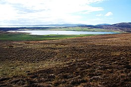
is a small, shallow, somewhat triangular-shaped loch located on
136:
545:
257:
253:
245:
237:
229:
221:
213:
205:
197:
193:
182:
172:
157:
142:
129:
90:
76:
23:
40:Looking roughly SW over moorland down to the loch.
91:
285:. It lies 5 mi (8.0 km) southwest of
565:
241:41,000,000 cu ft (1,200,000 m)
8:
572:
558:
509:: CS1 maint: location missing publisher (
20:
378:"Loch of Kirbister - Groundwater of Holm"
58:
372:
370:
342:
340:
338:
336:
334:
332:
330:
328:
326:
324:
322:
320:
316:
502:
7:
526:
524:
544:. You can help Knowledge (XXG) by
14:
404:"New trout hatchery at Kirbister"
528:
408:Orkney Trout Fishing Association
57:
50:
34:
244:
236:
228:
220:
212:
204:
196:
178:8 sq mi (21 km)
29:Kirbister loch, Loch of Orphir
1:
165:Mill burn at south end in to
75:
596:Freshwater lochs of Scotland
461:National Library of Scotland
353:National Library of Scotland
485:; Pullar, Laurence (1910).
201:1.25 mi (2.01 km)
627:
523:
209:0.5 mi (0.80 km)
45:
33:
28:
217:227 acres (0.92 km)
16:Loch in Orkney, Scotland
611:Orkney geography stubs
540:location article is a
249:52 ft (16 m)
233:6 ft (1.8 m)
225:4 ft (1.2 m)
114:58.95222°N 3.09333°W
281:, in the parish of
263:Holm of Groundwater
110: /
119:58.95222; -3.09333
553:
552:
302:Sir John Murray's
271:Loch of Kirbister
267:
266:
246:Surface elevation
65:Loch of Kirbister
24:Loch of Kirbister
618:
606:Mainland, Orkney
574:
567:
560:
532:
525:
515:
514:
508:
500:
498:
496:
479:
473:
472:
470:
468:
452:
446:
445:
443:
441:
430:"Kirbister Mill"
426:
420:
419:
417:
415:
400:
394:
393:
391:
389:
374:
365:
364:
362:
360:
344:
161:
160:Primary outflows
146:
125:
124:
122:
121:
120:
115:
111:
108:
107:
106:
103:
93:
61:
60:
54:
38:
21:
626:
625:
621:
620:
619:
617:
616:
615:
601:Lakes of Orkney
591:Lochs of Orkney
581:
580:
579:
578:
521:
519:
518:
501:
494:
492:
481:
480:
476:
466:
464:
454:
453:
449:
439:
437:
428:
427:
423:
413:
411:
402:
401:
397:
387:
385:
376:
375:
368:
358:
356:
346:
345:
318:
313:
275:Mainland Orkney
186: countries
145:Primary inflows
118:
116:
112:
109:
104:
101:
99:
97:
96:
81:Mainland Orkney
72:
71:
70:
69:
68:
67:
66:
62:
41:
17:
12:
11:
5:
624:
622:
614:
613:
608:
603:
598:
593:
583:
582:
577:
576:
569:
562:
554:
551:
550:
533:
517:
516:
474:
447:
421:
395:
366:
315:
314:
312:
309:
295:Kirbister Mill
265:
264:
261:
255:
254:
251:
250:
247:
243:
242:
239:
235:
234:
231:
227:
226:
223:
219:
218:
215:
211:
210:
207:
203:
202:
199:
195:
194:
191:
190:
187:
180:
179:
176:
174:Catchment area
170:
169:
163:
155:
154:
148:
140:
139:
133:
127:
126:
94:
88:
87:
78:
74:
73:
64:
63:
56:
55:
49:
48:
47:
46:
43:
42:
39:
31:
30:
26:
25:
15:
13:
10:
9:
6:
4:
3:
2:
623:
612:
609:
607:
604:
602:
599:
597:
594:
592:
589:
588:
586:
575:
570:
568:
563:
561:
556:
555:
549:
547:
543:
539:
534:
531:
527:
522:
512:
506:
490:
489:
484:
478:
475:
463:
462:
457:
451:
448:
435:
431:
425:
422:
409:
405:
399:
396:
383:
379:
373:
371:
367:
355:
354:
349:
343:
341:
339:
337:
335:
333:
331:
329:
327:
325:
323:
321:
317:
310:
308:
306:
303:
298:
296:
291:
288:
284:
280:
276:
272:
262:
260:
256:
252:
248:
240:
232:
224:
222:Average depth
216:
208:
200:
192:
188:
185:
181:
177:
175:
171:
168:
167:Waulkmill Bay
164:
162:
156:
153:
149:
147:
141:
138:
134:
132:
128:
123:
95:
89:
86:
82:
79:
53:
44:
37:
32:
27:
22:
19:
546:expanding it
535:
520:
493:. Retrieved
487:
483:Murray, John
477:
465:. Retrieved
459:
450:
438:. Retrieved
433:
424:
412:. Retrieved
407:
398:
386:. Retrieved
381:
357:. Retrieved
351:
304:
299:
292:
270:
268:
238:Water volume
214:Surface area
18:
491:. Edinburgh
198:Max. length
135:freshwater
117: /
92:Coordinates
585:Categories
311:References
230:Max. depth
206:Max. width
102:58°57′08″N
505:cite book
467:11 August
440:11 August
414:11 August
388:11 August
359:11 August
436:. RCAHMS
384:. RCAHMS
287:Kirkwall
279:Scotland
189:Scotland
150:several
105:3°5′36″W
85:Scotland
77:Location
495:24 July
434:Canmore
382:Canmore
259:Islands
538:Orkney
410:. OTFA
283:Orphir
536:This
184:Basin
152:burns
542:stub
511:link
497:2013
469:2013
442:2013
416:2013
390:2013
361:2013
269:The
137:loch
131:Type
587::
507:}}
503:{{
458:.
432:.
406:.
380:.
369:^
350:.
319:^
307:.
297:.
277:,
83:,
573:e
566:t
559:v
548:.
513:)
499:.
471:.
444:.
418:.
392:.
363:.
Text is available under the Creative Commons Attribution-ShareAlike License. Additional terms may apply.