613:
553:
191:
1406:
160:
601:
565:
644:
577:
589:
1417:
625:
35:
198:
167:
60:
1295:
1390:
1326:
1310:
1300:
1516:
673:
1476:
1385:
1331:
1511:
668:
1471:
972:
1352:
1254:
1491:
1285:
1219:
1184:
511:
is seven miles (11 km) east of the pass in
Montana. The first limited services in Idaho are in Powell, thirteen miles (21 km) to the west of the pass, then another 65 miles (105 km) to
1259:
1164:
1124:
949:
1224:
1214:
1209:
1189:
1305:
1139:
1054:
612:
1174:
1169:
1044:
1264:
1229:
1134:
1109:
1249:
1199:
1179:
1154:
1144:
1129:
1119:
1104:
1084:
1059:
1049:
1039:
1269:
1244:
1149:
1089:
1069:
1064:
1034:
1024:
1204:
1159:
1099:
1074:
1029:
843:
1336:
1234:
1114:
1079:
1290:
1239:
1194:
1094:
1496:
1002:
987:
552:
1526:
942:
1018:
1466:
1501:
1446:
1461:
1420:
935:
290:
663:
121:
1410:
1441:
982:
643:
576:
159:
457:, but was probably a regular French nickname. The name Lolo was not used by Lewis and Clark. Its first known mention is in the 1810 journal of
486:, belatedly completed in 1962, crosses the pass. At the August dedication ceremony at Lolo Pass attended by thousands, the states' governors,
779:
752:
958:
245:
1506:
1456:
1373:
190:
1451:
722:
543:
884:
825:
600:
624:
564:
588:
895:
114:
911:
1486:
900:
1378:
1357:
439:
419:
254:
1531:
1481:
508:
458:
524:
82:
910:
411:
1521:
992:
483:
477:
997:
977:
803:
364:
17:
269:
546:
announced that 23 wolves had been killed in the Lolo Pass area, in order to boost elk populations.
461:, who described three fur trappers, probably of French descent, named Michael, Lolo, and Gregoire.
73:
45:
795:
715:
Seliš nyoʻnuntn, Medicine for the Salish language : English to Salish translation dictionary
532:
473:
878:
775:
769:
748:
742:
718:
399:
388:
890:
695:
927:
487:
442:, designated for its importance to the Lewis and Clark Expedition, and its role in the 1877
415:
368:
102:
873:
528:
372:
107:
738:
491:
403:
97:
449:
The name of the pass is sometimes said to have been Salish version of the French name
336:
1435:
512:
495:
465:
443:
360:
175:
90:
63:
1391:
University and college buildings listed on the
National Register of Historic Places
634:
520:
516:
502:
469:
431:
536:
499:
34:
848:
376:
305:
292:
136:
123:
356:
902:
The Lewis & Clark
Expedition: Documenting the Uncharted Northwest Name,
438:, the Corps of Discovery returned the following June. The Lolo Trail is a
430:, on their westward snowbound journey in September 1805. After a winter at
674:
National
Register of Historic Places listings in Missoula County, Montana
649:
427:
423:
904:
a
National Park Service Teaching with Historic Places (TwHP) lesson plan
717:(2nd ed.). Pablo, MT: Salish Kootenai College Press. p. 374.
380:
278:
210:
86:
1386:
List of jails and prisons on the
National Register of Historic Places
435:
669:
National
Register of Historic Places listings in Idaho County, Idaho
630:
384:
274:
206:
77:
1517:
National
Register of Historic Places in Missoula County, Montana
476:. Shortly after crossing the pass, the two sides clashed at the
931:
531:, 170 miles (270 km) west of the pass at the border with
874:
National Park
Service: Lolo Pass Visitor Center and Rest Area
1477:
Roads on the
National Register of Historic Places in Montana
1512:
National Register of Historic Places in Idaho County, Idaho
387:, approximately forty miles (65 km) west-southwest of
1472:
Roads on the National Register of Historic Places in Idaho
844:"Idaho Fish and Game kills 23 wolves in Lolo Pass area"
771:
Explorations Into the World of Lewis and Clark V-2 of 3
1492:
Mountains Ranges and Peaks in Missoula County, Montana
582:
Lolo Pass, Montana side, approaching summit, westbound
696:"National Historic Landmark nomination for Lolo Pass"
1366:
1345:
1319:
1278:
1011:
988:
History of the National Register of Historic Places
965:
342:
329:
321:
284:
265:
113:
96:
69:
54:
44:
27:
747:. University of Oklahoma Press. pp. 11, 255.
1019:List of U.S. National Historic Landmarks by state
652:blooming at Packer Meadows, near Lolo Pass, Idaho
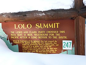
558:Nez Perce Trail Historical Marker, Lolo Pass 2017
527:. The primary city in Idaho served by U.S. 12 is
1411:National Register of Historic Places portal
744:Native American Placenames of the United States
394:The pass is the highest point of the historic
943:
8:
664:List of National Historic Landmarks in Idaho
1497:Transportation in Missoula County, Montana
950:
936:
928:
887:- roadside historical marker - Lolo Summit
826:"Thousands witness L-C Highway dedication"
464:The pass was also used in 1877 during the
24:
1527:Trails and roads in the American Old West
959:U.S. National Register of Historic Places
912:"Items from the Nez Perces Indians"
246:U.S. National Register of Historic Places
824:Campbell, Thomas W. (August 20, 1962).
702:. National Park Service. July 11, 2010.
684:
548:
39:Historical marker sign in Idaho in 2011
1467:National Historic Landmarks in Montana
229:
1502:Transportation in Idaho County, Idaho
1447:Landforms of Missoula County, Montana
774:. Digital Scanning Inc. p. 968.
690:
688:
494:of Montana, cut through a ceremonial
7:
1462:National Historic Landmarks in Idaho
891:Lolo Pass Visitor Information Center
700:National Register of Historic Places
375:. It is on the border between the
1374:National Historic Preservation Act
909:Lyman, Horace Sumner (June 1901).
14:
896:Lewis and Clark: Additional Sites
544:Idaho Department of Fish and Game
535:, where the Clearwater meets the
197:
166:
1442:Landforms of Idaho County, Idaho
1416:
1415:
1404:
642:
623:
618:Forest fire near Lolo Pass, 2003
611:
599:
587:
575:
563:
551:
418:in the 18th century, and by the
359:5,233 feet (1,595 m), is a
196:
189:
165:
158:
58:
33:
594:Entering Montana from Lolo Pass
523:to form the Middle Fork of the
468:as some of the Nez Perce under
406:in Idaho. The trail, known as
255:U.S. National Historic Landmark
1327:Federated States of Micronesia
973:Architectural style categories
331:
1:
180:Show map of the United States
570:Lolo Pass walking trail 2017
434:in present-day northwestern
227:United States historic place
917:Oregon Historical Quarterly
768:Saindon, Robert A. (2003).
515:, at the confluence of the
1548:
1507:Clearwater National Forest
1457:Mountain passes of Montana
1379:Historic Preservation Fund
1358:American Legation, Morocco
885:Idaho Transportation Dept.
879:Idaho Transportation Dept.
440:National Historic Landmark
420:Lewis and Clark Expedition
410:, or "Nez Perce Trail" in
15:
1399:
1320:Lists by associated state
330:NRHP reference
261:
252:
243:
236:
232:
152:
32:
1452:Mountain passes of Idaho
1301:Northern Mariana Islands
830:Lewiston Morning Tribune
800:Lewiston Morning Tribune
606:Lolo Pass visitor center
1296:Minor Outlying Islands
1279:Lists by insular areas
993:Keeper of the Register
713:Tachini, Pete (2010).
542:On March 1, 2014, the
478:Battle of the Big Hole
998:National Park Service
978:Contributing property
832:. (Idaho). p. 1.
804:National Park Service
796:"Lolo Trail and Pass"
365:western United States
18:Lolo (disambiguation)
1353:District of Columbia
881:- webcam - Lolo Pass
472:tried to escape the
270:Bitterroot Mountains
16:For other uses, see
637:, west of Lolo Pass
402:in Montana and the
302: /
133: /
1487:Borders of Montana
306:46.635°N 114.580°W
137:46.635°N 114.580°W
50:5,233 ft (1,595 m)
1429:
1428:
983:Historic district
781:978-1-58218-764-8
754:978-0-8061-3598-4
400:Bitterroot Valley
350:
349:
225:
224:
216:Show map of Idaho
1539:
1532:Bitterroot Range
1482:Borders of Idaho
1419:
1418:
1409:
1408:
1407:
1332:Marshall Islands
952:
945:
938:
929:
924:
914:
862:
861:
859:
857:
840:
834:
833:
821:
815:
814:
812:
810:
792:
786:
785:
765:
759:
758:
735:
729:
728:
710:
704:
703:
692:
646:
627:
615:
603:
591:
579:
567:
555:
509:Lolo Hot Springs
371:of the northern
369:Bitterroot Range
346:October 15, 1966
333:
317:
316:
314:
313:
312:
311:46.635; -114.580
307:
303:
300:
299:
298:
295:
230:
217:
205:Location on the
200:
199:
193:
181:
174:Location in the
169:
168:
162:
148:
147:
145:
144:
143:
142:46.635; -114.580
138:
134:
131:
130:
129:
126:
103:Bitterroot Range
62:
61:
37:
25:
1547:
1546:
1542:
1541:
1540:
1538:
1537:
1536:
1432:
1431:
1430:
1425:
1405:
1403:
1395:
1362:
1341:
1315:
1274:
1007:
961:
956:
908:
870:
865:
855:
853:
852:. March 1, 2014
842:
841:
837:
823:
822:
818:
808:
806:
794:
793:
789:
782:
767:
766:
762:
755:
739:Bright, William
737:
736:
732:
725:
712:
711:
707:
694:
693:
686:
682:
660:
653:
647:
638:
628:
619:
616:
607:
604:
595:
592:
583:
580:
571:
568:
559:
556:
484:U.S. Highway 12
373:Rocky Mountains
310:
308:
304:
301:
296:
293:
291:
289:
288:
273:
257:
248:
239:
228:
221:
220:
219:
218:
215:
214:
203:
202:
201:
184:
183:
182:
179:
178:
172:
171:
170:
141:
139:
135:
132:
127:
124:
122:
120:
119:
108:Rocky Mountains
106:
83:Missoula County
81:
59:
40:
21:
12:
11:
5:
1545:
1543:
1535:
1534:
1529:
1524:
1519:
1514:
1509:
1504:
1499:
1494:
1489:
1484:
1479:
1474:
1469:
1464:
1459:
1454:
1449:
1444:
1434:
1433:
1427:
1426:
1424:
1423:
1413:
1400:
1397:
1396:
1394:
1393:
1388:
1383:
1382:
1381:
1370:
1368:
1364:
1363:
1361:
1360:
1355:
1349:
1347:
1343:
1342:
1340:
1339:
1334:
1329:
1323:
1321:
1317:
1316:
1314:
1313:
1311:Virgin Islands
1308:
1303:
1298:
1293:
1288:
1286:American Samoa
1282:
1280:
1276:
1275:
1273:
1272:
1267:
1262:
1257:
1252:
1247:
1242:
1237:
1232:
1227:
1222:
1220:South Carolina
1217:
1212:
1207:
1202:
1197:
1192:
1187:
1185:North Carolina
1182:
1177:
1172:
1167:
1162:
1157:
1152:
1147:
1142:
1137:
1132:
1127:
1122:
1117:
1112:
1107:
1102:
1097:
1092:
1087:
1082:
1077:
1072:
1067:
1062:
1057:
1052:
1047:
1042:
1037:
1032:
1027:
1022:
1015:
1013:
1012:Lists by state
1009:
1008:
1006:
1005:
1003:Property types
1000:
995:
990:
985:
980:
975:
969:
967:
963:
962:
957:
955:
954:
947:
940:
932:
926:
925:
906:
898:
893:
888:
882:
876:
869:
868:External links
866:
864:
863:
835:
816:
787:
780:
760:
753:
730:
723:
705:
683:
681:
678:
677:
676:
671:
666:
659:
656:
655:
654:
648:
641:
639:
629:
622:
620:
617:
610:
608:
605:
598:
596:
593:
586:
584:
581:
574:
572:
569:
562:
560:
557:
550:
459:David Thompson
414:, was used by
404:Weippe Prairie
398:, between the
348:
347:
344:
340:
339:
334:
327:
326:
323:
319:
318:
286:
282:
281:
267:
263:
262:
259:
258:
253:
250:
249:
244:
241:
240:
237:
234:
233:
226:
223:
222:
204:
195:
194:
188:
187:
186:
185:
173:
164:
163:
157:
156:
155:
154:
153:
150:
149:
117:
111:
110:
100:
94:
93:
71:
67:
66:
56:
52:
51:
48:
42:
41:
38:
30:
29:
13:
10:
9:
6:
4:
3:
2:
1544:
1533:
1530:
1528:
1525:
1523:
1522:U.S. Route 12
1520:
1518:
1515:
1513:
1510:
1508:
1505:
1503:
1500:
1498:
1495:
1493:
1490:
1488:
1485:
1483:
1480:
1478:
1475:
1473:
1470:
1468:
1465:
1463:
1460:
1458:
1455:
1453:
1450:
1448:
1445:
1443:
1440:
1439:
1437:
1422:
1414:
1412:
1402:
1401:
1398:
1392:
1389:
1387:
1384:
1380:
1377:
1376:
1375:
1372:
1371:
1369:
1365:
1359:
1356:
1354:
1351:
1350:
1348:
1344:
1338:
1335:
1333:
1330:
1328:
1325:
1324:
1322:
1318:
1312:
1309:
1307:
1304:
1302:
1299:
1297:
1294:
1292:
1289:
1287:
1284:
1283:
1281:
1277:
1271:
1268:
1266:
1263:
1261:
1260:West Virginia
1258:
1256:
1253:
1251:
1248:
1246:
1243:
1241:
1238:
1236:
1233:
1231:
1228:
1226:
1223:
1221:
1218:
1216:
1213:
1211:
1208:
1206:
1203:
1201:
1198:
1196:
1193:
1191:
1188:
1186:
1183:
1181:
1178:
1176:
1173:
1171:
1168:
1166:
1165:New Hampshire
1163:
1161:
1158:
1156:
1153:
1151:
1148:
1146:
1143:
1141:
1138:
1136:
1133:
1131:
1128:
1126:
1125:Massachusetts
1123:
1121:
1118:
1116:
1113:
1111:
1108:
1106:
1103:
1101:
1098:
1096:
1093:
1091:
1088:
1086:
1083:
1081:
1078:
1076:
1073:
1071:
1068:
1066:
1063:
1061:
1058:
1056:
1053:
1051:
1048:
1046:
1043:
1041:
1038:
1036:
1033:
1031:
1028:
1026:
1023:
1020:
1017:
1016:
1014:
1010:
1004:
1001:
999:
996:
994:
991:
989:
986:
984:
981:
979:
976:
974:
971:
970:
968:
964:
960:
953:
948:
946:
941:
939:
934:
933:
930:
922:
918:
913:
907:
905:
903:
899:
897:
894:
892:
889:
886:
883:
880:
877:
875:
872:
871:
867:
851:
850:
845:
839:
836:
831:
827:
820:
817:
805:
801:
797:
791:
788:
783:
777:
773:
772:
764:
761:
756:
750:
746:
745:
740:
734:
731:
726:
724:9781934594063
720:
716:
709:
706:
701:
697:
691:
689:
685:
679:
675:
672:
670:
667:
665:
662:
661:
657:
651:
645:
640:
636:
632:
626:
621:
614:
609:
602:
597:
590:
585:
578:
573:
566:
561:
554:
549:
547:
545:
540:
538:
534:
530:
526:
522:
521:Selway Rivers
518:
514:
510:
506:
504:
501:
497:
493:
490:of Idaho and
489:
485:
481:
479:
475:
471:
467:
466:Nez Perce War
462:
460:
456:
452:
447:
445:
444:Nez Perce War
441:
437:
433:
429:
425:
421:
417:
413:
409:
405:
401:
397:
392:
390:
386:
382:
378:
374:
370:
366:
362:
361:mountain pass
358:
354:
345:
343:Added to NRHP
341:
338:
335:
328:
324:
320:
315:
287:
283:
280:
276:
271:
268:
264:
260:
256:
251:
247:
242:
235:
231:
212:
208:
192:
177:
176:United States
161:
151:
146:
118:
116:
112:
109:
104:
101:
99:
95:
92:
88:
84:
79:
75:
72:
68:
65:
57:
53:
49:
47:
43:
36:
31:
26:
23:
19:
1225:South Dakota
1215:Rhode Island
1210:Pennsylvania
1190:North Dakota
920:
916:
901:
854:. Retrieved
847:
838:
829:
819:
807:. Retrieved
799:
790:
770:
763:
743:
733:
714:
708:
699:
635:Lochsa River
541:
507:
503:crosscut saw
482:
480:in Montana.
470:Chief Joseph
463:
454:
450:
448:
432:Fort Clatsop
422:, guided by
407:
395:
393:
352:
351:
74:Idaho County
55:Traversed by
22:
1346:Other areas
1306:Puerto Rico
1140:Mississippi
1055:Connecticut
498:log with a
492:Tim Babcock
391:, Montana.
309: /
297:114°34′48″W
285:Coordinates
140: /
128:114°34′48″W
115:Coordinates
1436:Categories
1255:Washington
1175:New Mexico
1170:New Jersey
1045:California
849:Missoulian
809:October 8,
680:References
533:Washington
525:Clearwater
488:Bob Smylie
408:naptnišaqs
396:Lolo Trail
294:46°38′06″N
238:Lolo Trail
125:46°38′06″N
64:US 12
1265:Wisconsin
1230:Tennessee
1135:Minnesota
1110:Louisiana
474:U.S. Army
416:Nez Perce
367:, in the
357:elevation
353:Lolo Pass
46:Elevation
28:Lolo Pass
1421:Category
1250:Virginia
1200:Oklahoma
1180:New York
1155:Nebraska
1145:Missouri
1130:Michigan
1120:Maryland
1105:Kentucky
1085:Illinois
1060:Delaware
1050:Colorado
1040:Arkansas
856:June 12,
741:(2004).
658:See also
529:Lewiston
451:Laurence
428:Shoshone
424:Old Toby
389:Missoula
337:66000309
266:Location
70:Location
1367:Related
1270:Wyoming
1245:Vermont
1150:Montana
1090:Indiana
1070:Georgia
1065:Florida
1035:Arizona
1025:Alabama
500:two-man
455:Laurent
426:of the
381:Montana
363:in the
279:Montana
211:Montana
87:Montana
1205:Oregon
1160:Nevada
1100:Kansas
1075:Hawaii
1030:Alaska
966:Topics
778:
751:
721:
517:Lochsa
513:Lowell
436:Oregon
412:Salish
377:states
213:border
1337:Palau
1235:Texas
1115:Maine
1080:Idaho
650:Camas
631:Idaho
537:Snake
496:cedar
385:Idaho
322:Built
275:Idaho
207:Idaho
98:Range
78:Idaho
1291:Guam
1240:Utah
1195:Ohio
1095:Iowa
858:2014
811:2011
776:ISBN
749:ISBN
719:ISBN
519:and
383:and
325:1805
91:U.S.
633:'s
453:or
379:of
332:No.
80:, /
1438::
919:.
915:.
846:.
828:.
802:.
798:.
698:.
687:^
539:.
505:.
446:.
355:,
89:,
85:,
76:,
1021::
951:e
944:t
937:v
923:.
921:2
860:.
813:.
784:.
757:.
727:.
277:-
272:,
209:–
105:,
20:.
Text is available under the Creative Commons Attribution-ShareAlike License. Additional terms may apply.