63:
51:
75:
232:
74:
62:
297:
182:
273:
50:
302:
103:
292:
266:
217:
Jones Beach State
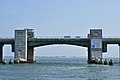
Parkway Channel Bascule Bridge LP-2, Route 908C spanning Long Creek southeast of Middle Bay, Hempstead, Nassau County, NY
259:
212:
129:
98:
231:
239:
20:
28:
243:
24:
286:
80:
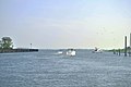
Looking toward
Freeport's "Nautical Mile" along Woodcleft Canal from Long Creek
197:
184:
176:
216:
124:
150:
219:", 3 photos, 3 data pages, 1 photo caption page
68:
Looking toward Long Creek from
Freeport's Woodcleft Canal
247:
267:
151:"New York OPD Geographic Information Gateway"
104:United States Environmental Protection Agency
8:
298:Bodies of water of Nassau County, New York
274:
260:
39:It is spanned by the Long Creek Bridge.
303:Nassau County, New York geography stubs
90:
46:
7:
228:
226:
213:Historic American Engineering Record
125:"The National Map - Advanced Viewer"
246:. You can help Knowledge (XXG) by
14:
238:This article about a location in
230:
73:
61:
49:
130:United States Geological Survey
1:
293:Channels of New York (state)
23:running roughly north from
319:
225:
215:(HAER) No. NY-177, "
99:"EPA – Waters GeoViewer"
240:Nassau County, New York
198:40.61333°N 73.57528°W
203:40.61333; -73.57528
194: /
179:on bridgehunter.com
29:Freeport, New York
255:
254:
177:Long Creek Bridge
155:opdgig.dos.ny.gov
56:Long Creek Bridge
310:
276:
269:
262:
234:
227:
209:
208:
206:
205:
204:
199:
195:
192:
191:
190:
187:
165:
164:
162:
161:
147:
141:
140:
138:
137:
121:
115:
114:
112:
111:
95:
77:
65:
53:
25:South Oyster Bay
19:is a salt-water
318:
317:
313:
312:
311:
309:
308:
307:
283:
282:
281:
280:
223:
202:
200:
196:
193:
188:
185:
183:
181:
180:
173:
168:
159:
157:
149:
148:
144:
135:
133:
123:
122:
118:
109:
107:
97:
96:
92:
88:
81:
78:
69:
66:
57:
54:
45:
37:
12:
11:
5:
316:
314:
306:
305:
300:
295:
285:
284:
279:
278:
271:
264:
256:
253:
252:
235:
221:
220:
210:
172:
171:External links
169:
167:
166:
142:
116:
89:
87:
84:
83:
82:
79:
72:
70:
67:
60:
58:
55:
48:
44:
41:
36:
33:
13:
10:
9:
6:
4:
3:
2:
315:
304:
301:
299:
296:
294:
291:
290:
288:
277:
272:
270:
265:
263:
258:
257:
251:
249:
245:
241:
236:
233:
229:
224:
218:
214:
211:
207:
178:
175:
174:
170:
156:
152:
146:
143:
132:
131:
126:
120:
117:
106:
105:
100:
94:
91:
85:
76:
71:
64:
59:
52:
47:
42:
40:
34:
32:
30:
26:
22:
18:
248:expanding it
237:
222:
158:. Retrieved
154:
145:
134:. Retrieved
128:
119:
108:. Retrieved
102:
93:
38:
16:
15:
201: /
287:Categories
189:73°34′31″W
186:40°36′48″N
160:2021-09-10
136:2021-07-30
110:2021-07-28
86:References
17:Long Creek
35:Crossings
43:Gallery
27:toward
21:channel
242:is a
244:stub
289::
153:.
127:.
101:.
31:.
275:e
268:t
261:v
250:.
163:.
139:.
113:.
Text is available under the Creative Commons Attribution-ShareAlike License. Additional terms may apply.