58:
50:
124:
031300010604, is named the Long Branch-Chestatee River sub-watershed, and drains an area of approximately 15 square miles southeast and south of
Dahlonega. The sub-watershed has an unusual shape in the form of the capital letter U, with the right arm of the U being formed by Long Branch, and the left
85:. The creek heads southwest in an almost completely straight line parallel to and immediately adjacent to State Route 115, which is named Long Branch Road from its crossing with the Chestatee River to its terminus at
229:
293:
193:
155:
288:
137:, the much longer tributary to the Chestatee River), and Bells Branch, along with 6 unnamed branches, before it departs the sub-watershed at its
249:
205:
89:. Long Branch picks up two unnamed branches from the east on its way to the Chestatee, and joins the river at the intersection of
126:
114:
101:
south of
Dahlonega, where US 19/SR 60 curve to the west to head to Dahlonega, and SR 155/Long Branch Road heads northeast.
134:
130:
57:
90:
86:
98:
78:
70:
94:
74:
150:
34:
160:
82:
49:
17:
121:
38:
61:
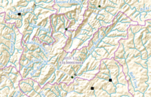
Map showing Long Branch and its sub-watershed (outlined in pink), and the
Chestatee River
118:
110:
282:
66:
138:
264:
251:
53:
Topographic map showing Long Branch and the
Chestatee River in the south
194:
ftp://rockyftp.cr.usgs.gov/vdelivery/Datasets/Staged/Hydro/FileGDB101/
125:
arm being formed by the
Chestatee River south of its confluence with
56:
48:
180:
41:. The creek is approximately 4.88 miles (7.85 km) long.
133:, Ralston Branch, Town Creek (not to be confused with
8:
206:"Geographic Names Information System (GNIS)"
129:. The Chestatee also receives the waters of
113:and associated waters is designated by the
156:South Atlantic-Gulf Water Resource Region
172:
224:
222:
7:
181:"National Hydrography Dataset (NHD)"
73:, just south of the intersection of
25:
294:Rivers of Lumpkin County, Georgia
232:. Environmental Protection Agency
183:. United States Geological Survey
115:United States Geological Survey
289:Rivers of Georgia (U.S. state)
1:
18:Long Branch (Chestatee River)
37:, and is a tributary of the
310:
192:file geodatabase (GDB) at
27:Stream in Georgia, U.S.
62:
54:
265:34.52056°N 83.91500°W
230:"EPA MyWaters Mapper"
151:Water Resource Region
105:Sub-watershed details
60:
52:
270:34.52056; -83.91500
261: /
161:Apalachicola basin
63:
55:
141:with Long Creek.
16:(Redirected from
301:
276:
275:
273:
272:
271:
266:
262:
259:
258:
257:
254:
241:
240:
238:
237:
226:
217:
216:
214:
213:
202:
196:
191:
189:
188:
177:
69:in southeastern
21:
309:
308:
304:
303:
302:
300:
299:
298:
279:
278:
269:
267:
263:
260:
255:
252:
250:
248:
247:
245:
244:
235:
233:
228:
227:
220:
211:
209:
204:
203:
199:
186:
184:
179:
178:
174:
169:
147:
107:
99:State Route 115
79:State Route 115
47:
39:Chestatee River
33:is a stream in
28:
23:
22:
15:
12:
11:
5:
307:
305:
297:
296:
291:
281:
280:
243:
242:
218:
197:
171:
170:
168:
165:
164:
163:
158:
153:
146:
143:
106:
103:
95:State Route 60
75:State Route 52
71:Lumpkin County
46:
43:
26:
24:
14:
13:
10:
9:
6:
4:
3:
2:
306:
295:
292:
290:
287:
286:
284:
277:
274:
231:
225:
223:
219:
207:
201:
198:
195:
182:
176:
173:
166:
162:
159:
157:
154:
152:
149:
148:
144:
142:
140:
136:
132:
128:
127:Yahoola Creek
123:
120:
116:
112:
104:
102:
100:
96:
92:
91:U.S. Route 19
88:
87:U.S. Route 19
84:
80:
76:
72:
68:
59:
51:
44:
42:
40:
36:
32:
19:
246:
234:. Retrieved
210:. Retrieved
200:
185:. Retrieved
175:
108:
65:Long Branch
64:
30:
29:
268: /
31:Long Branch
283:Categories
256:83°54′54″W
253:34°31′14″N
236:2015-12-22
212:2015-12-22
187:2015-12-22
167:References
139:confluence
135:Town Creek
131:Cane Creek
109:The creek
81:, east of
119:watershed
111:watershed
83:Dahlonega
145:See also
117:as sub-
35:Georgia
208:. USGS
45:Course
67:rises
77:and
122:HUC
285::
221:^
239:.
215:.
190:.
97:/
93:/
20:)
Text is available under the Creative Commons Attribution-ShareAlike License. Additional terms may apply.