451:
1554:
87:
77:
115:
545:
1011:
60:
450:
746:
of 2000, there were 10,422 people, 4,177 households, and 2,752 families residing in the township. The population density was 1,115.9 inhabitants per square mile (430.9/km). There were 4,360 housing units at an average density of 466.8 per square mile (180.2/km). The racial makeup of the township was
790:
In the township the population was spread out, with 23.1% under the age of 18, 5.7% from 18 to 24, 22.0% from 25 to 44, 26.6% from 45 to 64, and 22.6% who were 65 years of age or older. The median age was 45 years. For every 100 females there were 81.7 males. For every 100 females age 18 and over,
786:
living together, 5.6% had a female householder with no husband present, and 34.1% were non-families. 31.6% of all households were made up of individuals, and 19.7% had someone living alone who was 65 years of age or older. The average household size was 2.39 and the average family size was 3.03.
738:
As of the 2010 census, the township was 84.0% White, 6.9% Black or
African American, 0.1% Native American, 7.1% Asian, and 1.5% were two or more races. 1.9% of the population were of Hispanic or Latino ancestry.
1727:
392:. The township is considered a haven for those seeking a country lifestyle, while still being in close proximity to nearby towns and Center City Philadelphia. While its postal address is in
1376:
794:
The median income for a household in the township was $ 74,351, and the median income for a family was $ 97,991. Males had a median income of $ 71,027 versus $ 44,541 for females. The
28:
2469:
1682:
1652:
1049:
1667:
1582:
1572:
128:
114:
2474:
86:
1369:
2395:
1812:
460:
As of 2018, there were 64.43 miles (103.69 km) of public roads in Lower
Gwynedd Township, of which 16.85 miles (27.12 km) were maintained by the
76:
2214:
2075:
437:, the township has a total area of 9.4 square miles (24.2 km), of which 9.3 square miles (24.2 km) is land and 0.11% is water.
1883:
461:
1324:
1362:
302:
1722:
1637:
1632:
1742:
1697:
1612:
1304:
1075:
1717:
1627:
1737:
1732:
1707:
1702:
1642:
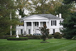
1587:
1102:
422:
1221:
1712:
1692:
1622:
1191:
1657:
1647:
1747:
1687:
1577:
1354:
1243:
2290:
1775:
1757:
1662:
1592:
1045:
980:
959:
938:
917:
896:
875:
854:
833:
826:
821:
530:
261:
479:
follows the Fort
Washington Expressway northwestward across the eastern portion of the township to its terminus, then joins the
2285:
2219:
1857:
1752:
1677:
1607:
1597:
1543:
1386:
373:
179:
2152:
1928:
1672:
1602:
776:
752:
522:
468:
2335:
2055:
1903:
1868:
1832:
1452:
1121:
772:
2370:
2320:
2254:
2229:
2203:
1893:
411:
Gwynedd was founded in 1698 by Welsh
Quakers. The township was then split into Lower Gwynedd and Upper Gwynedd in 1891.
385:
295:
17:
2439:
2340:
2157:
2095:
2065:
1847:
1837:
1522:
1269:
1021:
768:
514:
434:
544:
2416:
2365:
2330:
2090:
1995:
1964:
1959:
1888:
1852:
1447:
1442:
1163:
389:
1002:
Danielle
Duckett currently fills the position of the chair of the Board of Supervisors of Lower Gwynedd Township.
2375:
2325:
2315:
2300:
2270:
2193:
2060:
1817:
1791:
1492:
718:
703:
688:
673:
658:
643:
628:
613:
598:
583:
2401:
2390:
2385:
2380:
2350:
2224:
2188:
2131:
2080:
1979:
1933:
1923:
1898:
1878:
1873:
1807:
1517:
1487:
1472:
1457:
1437:
1432:
1408:
534:
490:
290:
782:
There were 4,177 households, out of which 29.2% had children under the age of 18 living with them, 58.6% were
2406:
2208:
2177:
2167:
2162:
2141:
2136:
2121:
2070:
2015:
1989:
1974:
1908:
1827:
1822:
1801:
1796:
1767:
1564:
1527:
1512:
1502:
1497:
1025:
1014:
498:
369:
50:
2265:
2260:
2249:
2244:
2239:
2183:
2116:
2035:
2010:
1954:
1949:
1938:
1842:
1507:
1482:
1477:
1467:
1419:
760:
538:
494:
476:
418:
2360:
2305:
2234:
2198:
2126:
2050:
2005:
1984:
1918:
1863:
1786:
1780:
1532:
1462:
1107:
472:
471:
follows Dekalb Pike on a northeast-southwest alignment across the northwestern portion of the township.
381:
282:
1071:
2446:
2411:
2280:
2172:
2146:
2106:
2100:
2085:
2045:
2040:
2000:
1944:
1538:
764:
393:
380:, United States. The population was 11,405 at the 2010 census. The township comprises four villages:
271:
2355:
2345:
2295:
2275:
2111:
2025:
1969:
756:
748:
486:
2310:
1913:
1311:
506:
798:
for the township was $ 41,868. About 1.2% of families and 2.7% of the population were below the
59:
1427:
795:
397:
1138:
331:
1199:
1235:
1010:
526:
510:
480:
364:
105:
2463:
1333:
799:
518:
414:
377:
64:
1290:
1401:
143:
130:
252:
475:
follows Welsh Road along the northeastern border of the township. Finally,
464:(PennDOT) and 47.58 miles (76.57 km) were maintained by the township.
2430:‡This populated place also has portions in an adjacent county or counties
802:, including 3.1% of those under age 18 and 3.0% of those age 65 or over.
783:
101:
743:
1305:"2020 CENSUS - SCHOOL DISTRICT REFERENCE MAP: Montgomery County, PA"
1349:
440:
The township has twenty miles of trails and 120 acres of parkland.
1009:
543:
502:
449:
278:
257:
1097:
316:
1358:
1344:
1552:
467:
Several numbered highways traverse Lower
Gwynedd Township.
349:
1265:
343:
337:
1190:(DVRPC), Delaware Valley Regional Planning Commission.
29:
Upper
Gwynedd Township, Montgomery County, Pennsylvania
18:
Lower
Gwynedd Township, Montgomery County, Pennsylvania
493:
runs through Lower
Gwynedd Township, with stations at
346:
340:
352:
2425:
2024:
1766:
1563:
1418:
334:
311:
301:
289:
268:
251:
243:
235:
227:
222:
214:
206:
198:
190:
185:
175:
167:
159:
41:
1334:http://www.montcopa.org/documentcenter/view/13404
1165:SEPTA Official Transit & Street Map Suburban
992:
984:
979:
971:
963:
958:
950:
942:
937:
927:
921:
916:
906:
900:
895:
885:
879:
874:
864:
858:
853:
843:
837:
832:
1370:
1028:is the district's comprehensive high school.
119:Location of Pennsylvania in the United States
8:
2470:Townships in Montgomery County, Pennsylvania
403:Lower Gwynedd Township was founded in 1698.
767:, 0.98% from two or more races, 0.26% from
454:PA 309 southbound in Lower Gwynedd Township
1377:
1363:
1355:
1236:"Census 2010: Pennsylvania - USATODAY.com"
556:
483:before exiting the township to the north.
38:
462:Pennsylvania Department of Transportation
809:
509:service to Lower Gwynedd Township along
1072:"Population and Housing Unit Estimates"
1037:
396:(19002), it is not associated with the
310:
300:
288:
250:
221:
213:
184:
158:
123:
98:
70:
56:
36:Township in Pennsylvania, United States
2475:Welsh-American culture in Pennsylvania
1098:"National Register Information System"
576:
363:
267:
242:
234:
226:
205:
197:
189:
174:
166:
111:
104:
7:
1103:National Register of Historic Places
1052:from the original on August 24, 2017
423:National Register of Historic Places
210:0.01 sq mi (0.03 km)
202:9.31 sq mi (24.1 km)
194:9.31 sq mi (24.1 km)
1385:Municipalities and communities of
1350:Local Business and Event Directory
1246:from the original on March 5, 2016
566:
25:
1078:from the original on May 29, 2017
548:A trail in Lower Gwynedd Township
531:Norristown Transportation Center
330:
113:
85:
75:
58:
1388:Montgomery County, Pennsylvania
1048:. United States Census Bureau.
812:Presidential elections results
1:
1139:"Lower Gwynedd Township map"
372:and equestrian community in
1270:United States Census Bureau
1046:"2016 U.S. Gazetteer Files"
1022:Wissahickon School District
435:United States Census Bureau
236: • Estimate
2491:
26:
2435:
1550:
1399:
1291:"Montco Election Results"
1122:"Lower Gwynedd Trail Map"
732:
717:
702:
687:
672:
657:
642:
627:
612:
597:
582:
575:
570:
565:
562:
529:, which runs between the
513:, which runs between the
247:1,200/sq mi (470/km)
124:
112:
99:
71:
57:
48:
1192:"DVRPC > Site Search"
491:Lansdale/Doylestown Line
218:348 ft (106 m)
27:Not to be confused with
1026:Wissahickon High School
1015:Wissahickon High School
806:Government and politics
791:there were 77.4 males.
1557:
1345:Lower Gwynedd Township
1017:
549:
477:Pennsylvania Route 309
455:
419:Jacob Kastner Loghouse
326:Lower Gwynedd Township
43:Lower Gwynedd Township
1556:
1266:"U.S. Census website"
1108:National Park Service
1013:
558:Historical population
547:
473:Pennsylvania Route 63
453:
270: • Summer (
144:40.21306°N 75.28361°W
2448:United States portal
394:Ambler, Pennsylvania
361:Welsh pronunciation:
244: • Density
2441:Pennsylvania portal
814:
559:
487:SEPTA Regional Rail
149:40.21306; -75.28361
140: /
2291:New Hanover Square
1808:Cheltenham Village
1776:Arcadia University
1558:
1312:U.S. Census Bureau
1018:
810:
557:
550:
456:
421:are listed on the
228: • Total
207: • Water
191: • Total
2457:
2456:
2286:Montgomery Square
2220:Huntingdon Valley
1858:Haverford College
1544:West Conshohocken
1000:
999:
796:per capita income
736:
735:
433:According to the
398:Borough of Ambler
374:Montgomery County
365:[ˈɡwɪnɛð]
323:
322:
296:215, 267, and 445
199: • Land
106:[ˈɡʊɨnɛð]
16:(Redirected from
2482:
2449:
2442:
2153:Fairview Village
1929:Plymouth Meeting
1728:Upper Providence
1723:Upper Pottsgrove
1638:Lower Providence
1633:Lower Pottsgrove
1555:
1411:
1404:
1394:
1389:
1379:
1372:
1365:
1356:
1327:
1322:
1320:
1318:
1309:
1301:
1295:
1294:
1287:
1281:
1280:
1278:
1276:
1262:
1256:
1255:
1253:
1251:
1232:
1226:
1225:
1218:
1212:
1211:
1209:
1207:
1202:on April 9, 2019
1198:. Archived from
1187:
1181:
1180:
1178:
1176:
1170:
1160:
1154:
1153:
1151:
1149:
1143:
1135:
1129:
1128:
1126:
1118:
1112:
1111:
1094:
1088:
1087:
1085:
1083:
1068:
1062:
1061:
1059:
1057:
1042:
815:
777:Pacific Islander
753:African American
578:
573:
568:
560:
367:
362:
359:
358:
355:
354:
351:
348:
345:
342:
339:
336:
319:
317:lowergwynedd.org
275:
155:
154:
152:
151:
150:
145:
141:
138:
137:
136:
133:
117:
108:
89:
79:
62:
39:
21:
2490:
2489:
2485:
2484:
2483:
2481:
2480:
2479:
2460:
2459:
2458:
2453:
2447:
2440:
2431:
2421:
2336:Port Providence
2056:Ashmead Village
2027:
2020:
1904:Montgomeryville
1869:King of Prussia
1833:Fort Washington
1762:
1743:West Pottsgrove
1698:Upper Frederick
1613:Lower Frederick
1559:
1553:
1548:
1453:East Greenville
1414:
1409:
1402:
1395:
1392:
1387:
1383:
1341:
1331:
1330:
1316:
1314:
1307:
1303:
1302:
1298:
1289:
1288:
1284:
1274:
1272:
1264:
1263:
1259:
1249:
1247:
1234:
1233:
1229:
1220:
1219:
1215:
1205:
1203:
1189:
1188:
1184:
1174:
1172:
1168:
1162:
1161:
1157:
1147:
1145:
1141:
1137:
1136:
1132:
1124:
1120:
1119:
1115:
1110:. July 9, 2010.
1096:
1095:
1091:
1081:
1079:
1070:
1069:
1065:
1055:
1053:
1044:
1043:
1039:
1034:
1008:
808:
784:married couples
773:Native American
571:
555:
523:Montgomery Mall
458:
457:
446:
431:
409:
388:, Penllyn, and
360:
333:
329:
315:
269:
148:
146:
142:
139:
134:
131:
129:
127:
126:
120:
95:
94:
93:
92:
83:
82:
67:
53:
44:
37:
32:
23:
22:
15:
12:
11:
5:
2488:
2486:
2478:
2477:
2472:
2462:
2461:
2455:
2454:
2452:
2451:
2444:
2436:
2433:
2432:
2429:
2427:
2423:
2422:
2420:
2419:
2414:
2409:
2404:
2399:
2393:
2388:
2383:
2378:
2373:
2371:Sassamansville
2368:
2363:
2358:
2353:
2348:
2343:
2338:
2333:
2328:
2323:
2321:Perkiomenville
2318:
2313:
2308:
2303:
2298:
2293:
2288:
2283:
2278:
2273:
2268:
2263:
2258:
2255:Line Lexington
2252:
2247:
2242:
2237:
2232:
2230:Lafayette Hill
2227:
2222:
2217:
2212:
2206:
2204:Gwynedd Valley
2201:
2196:
2191:
2186:
2181:
2175:
2170:
2165:
2160:
2155:
2150:
2144:
2139:
2134:
2129:
2124:
2119:
2114:
2109:
2104:
2098:
2093:
2088:
2083:
2078:
2073:
2068:
2063:
2058:
2053:
2048:
2043:
2038:
2032:
2030:
2022:
2021:
2019:
2018:
2013:
2008:
2003:
1998:
1993:
1987:
1982:
1977:
1972:
1967:
1962:
1957:
1952:
1947:
1942:
1936:
1931:
1926:
1921:
1916:
1911:
1906:
1901:
1896:
1894:Merion Station
1891:
1886:
1881:
1876:
1871:
1866:
1861:
1855:
1850:
1845:
1840:
1835:
1830:
1825:
1820:
1815:
1810:
1805:
1799:
1794:
1789:
1784:
1778:
1772:
1770:
1764:
1763:
1761:
1760:
1755:
1750:
1745:
1740:
1735:
1730:
1725:
1720:
1718:Upper Moreland
1715:
1710:
1705:
1700:
1695:
1690:
1685:
1680:
1675:
1670:
1665:
1660:
1655:
1650:
1645:
1640:
1635:
1630:
1628:Lower Moreland
1625:
1620:
1615:
1610:
1605:
1600:
1595:
1590:
1585:
1580:
1575:
1569:
1567:
1561:
1560:
1551:
1549:
1547:
1546:
1541:
1536:
1530:
1525:
1520:
1515:
1510:
1505:
1500:
1495:
1490:
1485:
1480:
1475:
1470:
1465:
1460:
1455:
1450:
1445:
1440:
1435:
1430:
1424:
1422:
1416:
1415:
1400:
1397:
1396:
1384:
1382:
1381:
1374:
1367:
1359:
1353:
1352:
1347:
1340:
1339:External links
1337:
1329:
1328:
1296:
1282:
1257:
1227:
1213:
1182:
1155:
1130:
1113:
1089:
1063:
1036:
1035:
1033:
1030:
1007:
1004:
998:
997:
991:
983:
977:
976:
970:
962:
956:
955:
949:
941:
935:
934:
926:
920:
914:
913:
905:
899:
893:
892:
884:
878:
872:
871:
863:
857:
851:
850:
842:
836:
830:
829:
824:
819:
807:
804:
734:
733:
730:
729:
726:
724:
721:
715:
714:
711:
709:
706:
700:
699:
696:
694:
691:
685:
684:
681:
679:
676:
670:
669:
666:
664:
661:
655:
654:
651:
649:
646:
640:
639:
636:
634:
631:
625:
624:
621:
619:
616:
610:
609:
606:
604:
601:
595:
594:
591:
589:
586:
580:
579:
574:
569:
564:
554:
551:
495:Gwynedd Valley
481:Bethlehem Pike
469:U.S. Route 202
448:
447:
445:
444:Transportation
442:
430:
427:
408:
405:
386:Gwynedd Valley
321:
320:
313:
309:
308:
305:
299:
298:
293:
287:
286:
276:
266:
265:
255:
249:
248:
245:
241:
240:
237:
233:
232:
229:
225:
224:
220:
219:
216:
212:
211:
208:
204:
203:
200:
196:
195:
192:
188:
187:
183:
182:
177:
173:
172:
169:
165:
164:
161:
157:
156:
122:
121:
118:
110:
109:
97:
96:
90:
84:
80:
74:
73:
72:
69:
68:
63:
55:
54:
49:
46:
45:
42:
35:
24:
14:
13:
10:
9:
6:
4:
3:
2:
2487:
2476:
2473:
2471:
2468:
2467:
2465:
2450:
2445:
2443:
2438:
2437:
2434:
2428:
2424:
2418:
2415:
2413:
2410:
2408:
2405:
2403:
2400:
2397:
2394:
2392:
2389:
2387:
2384:
2382:
2379:
2377:
2374:
2372:
2369:
2367:
2364:
2362:
2359:
2357:
2354:
2352:
2349:
2347:
2344:
2342:
2341:Prospectville
2339:
2337:
2334:
2332:
2329:
2327:
2324:
2322:
2319:
2317:
2314:
2312:
2309:
2307:
2304:
2302:
2299:
2297:
2294:
2292:
2289:
2287:
2284:
2282:
2279:
2277:
2274:
2272:
2269:
2267:
2264:
2262:
2259:
2256:
2253:
2251:
2248:
2246:
2243:
2241:
2238:
2236:
2233:
2231:
2228:
2226:
2223:
2221:
2218:
2216:
2213:
2210:
2207:
2205:
2202:
2200:
2197:
2195:
2192:
2190:
2187:
2185:
2182:
2179:
2176:
2174:
2171:
2169:
2166:
2164:
2161:
2159:
2158:Fitzwatertown
2156:
2154:
2151:
2148:
2145:
2143:
2140:
2138:
2135:
2133:
2130:
2128:
2125:
2123:
2120:
2118:
2115:
2113:
2110:
2108:
2105:
2102:
2099:
2097:
2096:Center Square
2094:
2092:
2089:
2087:
2084:
2082:
2079:
2077:
2074:
2072:
2069:
2067:
2066:Belmont Hills
2064:
2062:
2059:
2057:
2054:
2052:
2049:
2047:
2044:
2042:
2039:
2037:
2034:
2033:
2031:
2029:
2023:
2017:
2014:
2012:
2009:
2007:
2004:
2002:
1999:
1997:
1994:
1991:
1988:
1986:
1983:
1981:
1978:
1976:
1973:
1971:
1968:
1966:
1963:
1961:
1958:
1956:
1953:
1951:
1948:
1946:
1943:
1940:
1937:
1935:
1932:
1930:
1927:
1925:
1922:
1920:
1917:
1915:
1912:
1910:
1907:
1905:
1902:
1900:
1897:
1895:
1892:
1890:
1887:
1885:
1882:
1880:
1877:
1875:
1872:
1870:
1867:
1865:
1862:
1859:
1856:
1854:
1851:
1849:
1848:Halfway House
1846:
1844:
1841:
1839:
1838:Gilbertsville
1836:
1834:
1831:
1829:
1826:
1824:
1821:
1819:
1816:
1814:
1811:
1809:
1806:
1803:
1800:
1798:
1795:
1793:
1790:
1788:
1785:
1782:
1779:
1777:
1774:
1773:
1771:
1769:
1765:
1759:
1756:
1754:
1751:
1749:
1746:
1744:
1741:
1739:
1738:West Norriton
1736:
1734:
1733:Upper Salford
1731:
1729:
1726:
1724:
1721:
1719:
1716:
1714:
1711:
1709:
1708:Upper Hanover
1706:
1704:
1703:Upper Gwynedd
1701:
1699:
1696:
1694:
1691:
1689:
1686:
1684:
1681:
1679:
1676:
1674:
1671:
1669:
1666:
1664:
1661:
1659:
1656:
1654:
1651:
1649:
1646:
1644:
1643:Lower Salford
1641:
1639:
1636:
1634:
1631:
1629:
1626:
1624:
1621:
1619:
1618:Lower Gwynedd
1616:
1614:
1611:
1609:
1606:
1604:
1601:
1599:
1596:
1594:
1591:
1589:
1588:East Norriton
1586:
1584:
1581:
1579:
1576:
1574:
1571:
1570:
1568:
1566:
1562:
1545:
1542:
1540:
1537:
1534:
1531:
1529:
1526:
1524:
1523:Schwenksville
1521:
1519:
1516:
1514:
1511:
1509:
1506:
1504:
1501:
1499:
1496:
1494:
1491:
1489:
1486:
1484:
1481:
1479:
1476:
1474:
1471:
1469:
1466:
1464:
1461:
1459:
1456:
1454:
1451:
1449:
1446:
1444:
1441:
1439:
1436:
1434:
1431:
1429:
1426:
1425:
1423:
1421:
1417:
1413:
1412:
1405:
1398:
1393:United States
1390:
1380:
1375:
1373:
1368:
1366:
1361:
1360:
1357:
1351:
1348:
1346:
1343:
1342:
1338:
1336:
1335:
1326:
1313:
1306:
1300:
1297:
1292:
1286:
1283:
1271:
1267:
1261:
1258:
1245:
1241:
1237:
1231:
1228:
1223:
1222:"Census 2020"
1217:
1214:
1201:
1197:
1196:www.dvrpc.org
1193:
1186:
1183:
1167:
1166:
1159:
1156:
1140:
1134:
1131:
1123:
1117:
1114:
1109:
1105:
1104:
1099:
1093:
1090:
1077:
1073:
1067:
1064:
1051:
1047:
1041:
1038:
1031:
1029:
1027:
1023:
1020:It is in the
1016:
1012:
1005:
1003:
996:
990:
987:
982:
978:
975:
969:
966:
961:
957:
954:
948:
945:
940:
936:
933:
930:
925:
919:
915:
912:
909:
904:
898:
894:
891:
888:
883:
877:
873:
870:
867:
862:
856:
852:
849:
846:
841:
835:
831:
828:
825:
823:
820:
817:
816:
813:
805:
803:
801:
797:
792:
788:
785:
780:
778:
774:
770:
766:
762:
758:
754:
750:
745:
740:
731:
727:
725:
722:
720:
716:
712:
710:
707:
705:
701:
697:
695:
692:
690:
686:
682:
680:
677:
675:
671:
667:
665:
662:
660:
656:
652:
650:
647:
645:
641:
637:
635:
632:
630:
626:
622:
620:
617:
615:
611:
607:
605:
602:
600:
596:
592:
590:
587:
585:
581:
561:
552:
546:
542:
540:
536:
532:
528:
524:
520:
516:
515:Chestnut Hill
512:
508:
504:
500:
496:
492:
488:
484:
482:
478:
474:
470:
465:
463:
452:
443:
441:
438:
436:
428:
426:
424:
420:
416:
412:
406:
404:
401:
399:
395:
391:
387:
383:
379:
375:
371:
366:
357:
327:
318:
314:
306:
304:
297:
294:
292:
284:
280:
277:
273:
263:
259:
256:
254:
246:
238:
230:
217:
209:
201:
193:
181:
178:
170:
163:United States
162:
153:
125:Coordinates:
116:
107:
103:
88:
78:
66:
61:
52:
47:
40:
34:
30:
19:
2417:Zieglerville
2366:Salfordville
2331:Port Kennedy
2091:Center Point
1996:Willow Grove
1965:Spring Mount
1960:Spring House
1889:Melrose Park
1853:Harleysville
1713:Upper Merion
1693:Upper Dublin
1623:Lower Merion
1617:
1448:Conshohocken
1443:Collegeville
1407:
1332:
1315:. Retrieved
1299:
1285:
1273:. Retrieved
1260:
1248:. Retrieved
1240:usatoday.com
1239:
1230:
1216:
1204:. Retrieved
1200:the original
1195:
1185:
1173:. Retrieved
1171:(Map). SEPTA
1164:
1158:
1146:. Retrieved
1133:
1116:
1101:
1092:
1080:. Retrieved
1066:
1054:. Retrieved
1040:
1019:
1001:
994:
988:
985:
973:
967:
964:
952:
946:
943:
931:
928:
923:
910:
907:
902:
889:
886:
881:
868:
865:
860:
847:
844:
839:
811:
800:poverty line
793:
789:
781:
775:, and 0.01%
741:
737:
553:Demographics
519:Philadelphia
507:Suburban Bus
485:
466:
459:
439:
432:
415:Gwynedd Hall
413:
410:
402:
390:Spring House
378:Pennsylvania
325:
324:
307:42-091-44920
171:Pennsylvania
65:Gwynedd Hall
33:
2376:Spring Mill
2326:Port Indian
2316:Penn Valley
2301:North Hills
2271:Meadowbrook
2194:Gulph Mills
2061:Barren Hill
2028:communities
1818:Elkins Park
1792:Bala Cynwyd
1683:Springfield
1658:New Hanover
1648:Marlborough
1493:North Wales
1403:County seat
1275:January 31,
769:other races
517:section of
147: /
100:Etymology:
2464:Categories
2402:West Point
2396:Unionville
2391:Tylersport
2386:Three Tuns
2381:Sumneytown
2351:Roychester
2225:Jarrettown
2189:Graterford
2132:Earlington
2081:Cedarbrook
1980:Swedesburg
1934:Pottsgrove
1924:Penn Wynne
1899:Mont Clare
1879:Maple Glen
1874:Kulpsville
1813:Eagleville
1748:Whitemarsh
1688:Towamencin
1653:Montgomery
1578:Cheltenham
1518:Royersford
1488:Norristown
1473:Jenkintown
1458:Green Lane
1438:Bryn Athyn
1433:Bridgeport
1410:Norristown
1056:August 14,
1032:References
827:Democratic
822:Republican
742:As of the
535:Norristown
291:Area codes
223:Population
180:Montgomery
135:75°17′01″W
132:40°12′47″N
2426:Footnotes
2407:Worcester
2215:Hollywood
2209:Haverford
2178:Geryville
2168:Frederick
2163:Franconia
2142:Erdenheim
2137:Edge Hill
2122:Crestmont
2076:Camp Hill
2071:Bethayres
2016:Wynnewood
1990:Villanova
1975:Swedeland
1828:Flourtown
1823:Evansburg
1802:Bryn Mawr
1797:Blue Bell
1758:Worcester
1663:Perkiomen
1593:Franconia
1565:Townships
1528:Souderton
1513:Rockledge
1503:Pottstown
1498:Pennsburg
1325:Text list
1250:April 25,
1206:April 25,
1148:March 10,
1144:. PennDOT
1006:Education
505:provides
429:Geography
303:FIPS code
253:Time zone
215:Elevation
2266:Mainland
2261:Linfield
2250:Lederach
2245:Layfield
2240:Laverock
2184:Gladwyne
2117:Creamery
2036:Abington
2011:Wyndmoor
1955:Skippack
1950:Sanatoga
1939:Rosemont
1909:Oak Lane
1884:McKinley
1843:Glenside
1753:Whitpain
1678:Skippack
1668:Plymouth
1608:Limerick
1598:Hatfield
1583:Douglass
1573:Abington
1508:Red Hill
1483:Narberth
1478:Lansdale
1468:Hatfield
1420:Boroughs
1317:June 18,
1244:Archived
1076:Archived
1050:Archived
771:, 0.08%
761:Hispanic
759:, 1.05%
755:, 4.10%
751:, 7.78%
539:Lansdale
527:Route 96
521:and the
511:Route 94
417:and the
370:township
51:Township
2361:Salford
2306:Obelisk
2235:La Mott
2199:Gwynedd
2127:Dresher
2051:Ardsley
2006:Wyncote
1985:Trooper
1919:Oreland
1864:Horsham
1787:Audubon
1781:Ardmore
1673:Salford
1603:Horsham
1533:Telford
1463:Hatboro
1082:June 9,
747:86.80%
499:Penllyn
407:History
382:Gwynedd
368:) is a
312:Website
160:Country
102:Gwynedd
2412:Yerkes
2281:Miquon
2173:Fulmor
2147:Eureka
2107:Colmar
2101:Chapel
2086:Cedars
2046:Arcola
2041:Ambler
2001:Woxall
1945:Roslyn
1539:Trappe
1428:Ambler
1175:May 2,
993:34.0%
972:40.6%
951:45.6%
922:49.6%
901:44.8%
880:49.4%
859:37.4%
838:34.7%
765:Latino
744:census
723:12,076
708:11,405
693:10,422
563:Census
525:, and
239:11,558
231:11,405
176:County
2356:Rydal
2346:Rahns
2296:Noble
2276:Mingo
2112:Congo
2026:Other
1970:Stowe
1308:(PDF)
1169:(PDF)
1142:(PDF)
1125:(PDF)
995:1,348
989:2,031
986:51.2%
974:2,132
968:2,725
965:51.9%
953:2,726
947:3,134
944:52.4%
932:3,589
929:50.0%
924:3,557
911:4,037
908:54.7%
903:3,312
890:3,603
887:49.9%
882:3,572
869:4,343
866:58.8%
861:2,766
848:5,434
845:63.9%
840:2,952
818:Year
757:Asian
749:White
683:44.3%
678:9,958
663:6,902
653:39.9%
648:6,361
638:83.7%
633:4,546
623:24.2%
618:2,475
603:1,992
588:1,847
503:SEPTA
279:UTC-4
258:UTC-5
168:State
2311:Palm
1914:Oaks
1768:CDPs
1319:2024
1277:2008
1252:2018
1208:2018
1177:2016
1150:2023
1084:2017
1058:2017
981:1992
960:1996
939:2000
918:2004
897:2008
876:2012
855:2016
834:2020
728:5.9%
719:2020
713:9.4%
704:2010
698:4.7%
689:2000
674:1990
668:8.5%
659:1980
644:1970
629:1960
614:1950
608:7.9%
599:1940
584:1930
572:Note
567:Pop.
537:and
497:and
186:Area
91:Seal
81:Flag
763:or
533:in
489:'s
283:EDT
272:DST
262:EST
2466::
1406::
1391:,
1323:-
1310:.
1268:.
1242:.
1238:.
1194:.
1106:.
1100:.
1074:.
1024:.
779:.
577:%±
541:.
501:.
425:.
400:.
384:,
376:,
2398:‡
2257:‡
2211:‡
2180:‡
2149:‡
2103:‡
1992:‡
1941:‡
1860:‡
1804:‡
1783:‡
1535:‡
1378:e
1371:t
1364:v
1321:.
1293:.
1279:.
1254:.
1224:.
1210:.
1179:.
1152:.
1127:.
1086:.
1060:.
593:—
356:/
353:d
350:ɛ
347:n
344:ɪ
341:w
338:ɡ
335:ˈ
332:/
328:(
285:)
281:(
274:)
264:)
260:(
31:.
20:)
Text is available under the Creative Commons Attribution-ShareAlike License. Additional terms may apply.