45:
634:
344:
709:
322:
278:
256:
300:
202:. It has good traffic accessibility and is located in the Sava and Krka Valleys, with hilly areas with vineyards and an abundance of water. It is the second-smallest statistical region in Slovenia. The only nuclear power plant in the country and Čatež spa are located in the region. The region annually spends EUR 22 million on
206:. In 2013, the employment rate in the region was 57.5%. The region was characterized by the largest difference between the employment rate for men and for women (for men it was 12 percentage points higher than for women). In 2013 this region also stood out in number of convicted persons per 1,000 population (8.3).
168:
673:
523:Šprah, Lilijana, Tatjana Novak, & Jerneja Fridl. 2016. The Wellbeing of Slovenia's Population by Region: Comparison of Indicators with an Emphasis on Health.
610:
722:
761:
693:
658:
384:
653:
698:
603:
374:
550:
648:
619:
195:
35:
633:
510:
Lapuh, Lucija. 2016. Measuring the Impact of the
Recession on Slovenian Statistical Regions and their Ability to Recover.
643:
596:
766:
688:
668:
536:
Boršič, Darja, & Alenka
Kavkler. 2009. Modeling Unemployment Duration in Slovenia Using Cox Regression Models.
379:
366:
52:
567:
394:
44:
663:
203:
389:
683:
399:
156:
708:
343:
411:
The population in 2020 was 70,349. It has a total area of 885 square kilometers (342 sq mi).
347:
181:
488:(bachelor's thesis). Ljubljana: University of Ljubljana, Department of Geography, p. 37.
755:
588:
321:
461:
583:
259:
227:
65:
737:
724:
325:
623:
428:
281:
223:
199:
303:
277:
255:
419:
Employment structure: 45.8% services, 50% industry, 4.2% agriculture.
299:
219:
215:
146:
592:
443:
Length of other roads: 2,346.3 kilometers (1,457.9 mi)
499:
462:"Sub-national HDI - Area Database - Global Data Lab"
427:
It attracts 5.1% of the total number of tourists in
440:
Length of motorways: 36.6 kilometers (22.7 mi)
155:
142:
134:
126:
118:
110:
105:
97:
89:
84:
76:
71:
61:
51:
21:
568:"Prebivalstvo po: OBČINA/NASELJE, LETO, MERITVE"
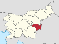
365:The Lower Sava Statistical Region comprises six
486:Energetika v Spodnjeposavski statistični regiji
604:
214:The Lower Sava Statistical Region includes 5
189:
8:
611:
597:
589:
18:
232:
135: • College/university students
453:
154:
104:
83:
70:
60:
50:
41:
141:
133:
125:
117:
109:
96:
88:
75:
7:
431:, most being from Slovenia (53%).
191:spodnjeposavska statistična regija
127: • Registered unemployed
14:
584:Slovenian regions in figures 2014
143: • Regional GDP (2019):
80:885 km (342 sq mi)
707:
632:
342:
320:
298:
276:
254:
43:
762:Statistical regions of Slovenia
1:
178:Lower Sava Statistical Region
23:Lower Sava Statistical Region
222:, the largest of which are
186:posavska statistična regija
27:posavska statistična regija
783:
551:"Naselja s statusom mesta"
525:Acta Geographica Slovenica
514:56(2): 247–256, pp. 252ff.
512:Acta Geographica Slovenica
501:. OECD Publishing, p. 324.
188:; until December 31, 2014
705:
639:
630:
538:Transition Studies Review
42:
33:
204:environmental protection
674:Littoral–Inner Carniola
540:54(1): 145–156, p. 148.
151:(EUR 19,456 per capita)
111: • Households
190:
185:
101:79/km (210/sq mi)
738:45.93333°N 15.43333°E
484:Žibert, Mojca. 2014.
466:hdi.globaldatalab.org
119: • Employed
527:54(1): 67–87, p. 68.
385:Kostanjevica na Krki
348:Kostanjevica na Krki
98: • Density
734: /
620:Statistical regions
234:
743:45.93333; 15.43333
694:Southeast Slovenia
244:Population (2021)
233:
196:statistical region
90: • Total
77: • Total
36:Statistical region
16:Statistical region
767:Lower Sava Valley
716:
715:
375:Bistrica ob Sotli
358:
357:
174:
173:
774:
749:
748:
746:
745:
744:
739:
735:
732:
731:
730:
727:
711:
654:Central Slovenia
636:
613:
606:
599:
590:
576:
575:
564:
558:
557:
555:
547:
541:
534:
528:
521:
515:
508:
502:
495:
489:
482:
476:
475:
473:
472:
458:
346:
324:
302:
280:
258:
235:
210:Cities and towns
193:
166:
47:
19:
782:
781:
777:
776:
775:
773:
772:
771:
752:
751:
742:
740:
736:
733:
728:
725:
723:
721:
720:
719:
717:
712:
703:
637:
626:
617:
580:
579:
566:
565:
561:
553:
549:
548:
544:
535:
531:
522:
518:
509:
505:
496:
492:
483:
479:
470:
468:
460:
459:
455:
450:
437:
425:
417:
409:
404:
363:
354:
339:
332:
317:
310:
295:
288:
273:
266:
251:
212:
164:
163:
150:
38:
29:
24:
17:
12:
11:
5:
780:
778:
770:
769:
764:
754:
753:
714:
713:
706:
704:
702:
701:
699:Upper Carniola
696:
691:
686:
681:
676:
671:
666:
661:
656:
651:
646:
640:
638:
631:
628:
627:
618:
616:
615:
608:
601:
593:
587:
586:
578:
577:
559:
542:
529:
516:
503:
490:
477:
452:
451:
449:
446:
445:
444:
441:
436:
435:Transportation
433:
424:
421:
416:
413:
408:
405:
403:
402:
397:
392:
387:
382:
377:
371:
367:municipalities
362:
361:Municipalities
359:
356:
355:
352:
350:
340:
337:
334:
333:
330:
328:
318:
315:
312:
311:
308:
306:
296:
293:
290:
289:
286:
284:
274:
271:
268:
267:
264:
262:
252:
249:
246:
245:
242:
239:
211:
208:
172:
171:
160:
153:
152:
144:
140:
139:
136:
132:
131:
128:
124:
123:
120:
116:
115:
112:
108:
107:
103:
102:
99:
95:
94:
91:
87:
86:
82:
81:
78:
74:
73:
69:
68:
63:
59:
58:
55:
53:Municipalities
49:
48:
40:
39:
34:
31:
30:
25:
22:
15:
13:
10:
9:
6:
4:
3:
2:
779:
768:
765:
763:
760:
759:
757:
750:
747:
710:
700:
697:
695:
692:
690:
687:
685:
682:
680:
677:
675:
672:
670:
667:
665:
662:
660:
659:Coastal–Karst
657:
655:
652:
650:
647:
645:
642:
641:
635:
629:
625:
621:
614:
609:
607:
602:
600:
595:
594:
591:
585:
582:
581:
573:
569:
563:
560:
552:
546:
543:
539:
533:
530:
526:
520:
517:
513:
507:
504:
500:
494:
491:
487:
481:
478:
467:
463:
457:
454:
447:
442:
439:
438:
434:
432:
430:
422:
420:
414:
412:
406:
401:
398:
396:
393:
391:
388:
386:
383:
381:
378:
376:
373:
372:
370:
368:
360:
351:
349:
345:
341:
336:
335:
329:
327:
323:
319:
314:
313:
307:
305:
301:
297:
292:
291:
285:
283:
279:
275:
270:
269:
263:
261:
257:
253:
248:
247:
243:
240:
237:
236:
231:
229:
225:
221:
217:
209:
207:
205:
201:
197:
192:
187:
183:
179:
170:
161:
158:
148:
145:
137:
129:
121:
113:
100:
92:
79:
67:
64:
56:
54:
46:
37:
32:
28:
20:
718:
678:
649:Central Sava
571:
562:
545:
537:
532:
524:
519:
511:
506:
498:
497:OECD. 2012.
493:
485:
480:
469:. Retrieved
465:
456:
426:
418:
410:
407:Demographics
364:
213:
177:
175:
62:Largest town
26:
741: /
756:Categories
729:15°26′00″E
726:45°56′00″N
679:Lower Sava
471:2021-07-20
106:Statistics
85:Population
644:Carinthia
165:very high
624:Slovenia
429:Slovenia
200:Slovenia
149:1,475 bn
689:Savinja
669:Gorizia
448:Sources
423:Tourism
415:Economy
400:Sevnica
380:Brežice
304:Sevnica
260:Brežice
228:Brežice
194:) is a
182:Slovene
66:Brežice
572:PX-Web
395:Radeče
326:Radeče
216:cities
159:(2019)
93:70,349
664:Drava
554:(PDF)
390:Krško
331:1,949
309:4,521
287:6,778
282:Krško
265:6,888
241:Name
238:Rank
224:Krško
220:towns
162:0.888
122:23414
114:30147
684:Mura
226:and
218:and
176:The
138:3019
130:4695
72:Area
622:of
353:702
198:in
169:8th
157:HDI
147:EUR
758::
570:.
464:.
369::
338:5.
316:4.
294:3.
272:2.
250:1.
230:.
184::
167:·
612:e
605:t
598:v
574:.
556:.
474:.
180:(
57:6
Text is available under the Creative Commons Attribution-ShareAlike License. Additional terms may apply.