58:
403:
414:
445:
422:
road a little further back from the Lowes Loch. It has been abandoned since before the 1950s, shown as active in 1914 from the record of the OS map. A photograph of the early 1900s shows a substantial and unusual design for a farm building; L-shaped and 'Council House' like in appearance. The OS map shows that this later building had an orchard or ornamental garden and was more of a dwelling than a farm, being occupied by a family who owned the
Cunningham bus company in
480:
352:. The Davie's o'the Mill ruins lie nearby, once powered by a burn that runs down from the Saint Inan's well site and at one time the westward flow from the Lowes Lochs prior to the canalising of the Cadgerford Burn. A right of way still runs down to the site from near Cauldhame Cottage and a lane runs up to the old mill from near Mill o'Beith and the Warlock Craigie. Lying quite close to Loanhead Quarry the steading is now a ruin (2011).
341:
315:
42:
274:'s map of circa 1604, names a 'Loch of Hill' and Roy's map of circa 1747 shows two small lochs, with the outflow of the western loch running down to the Muir Burn and then into the Roebank Burn. Thomson's map of 1832 shows a single loch lying below Lows Farm and draining east into the Dusk water. OS maps of the 1850s do not indicate open water and a discreet clump of trees suggests a small island.
507:
291:
65:
452:
514:
This small lochan (0.214 acres) is located on the south-facing slopes of Cuff Hill and may be artificial, as suggested by the number of old whinstone quarries in the vicinity. It is marked on the 1858 OS map and was deepened and modified for use as a reservoir, with a sluice and filter bed, probably
433:
In 1956 it is recorded that a Mr.Newall found a stone slab built into the ruin of
Lochlands, presumably the more modern building, bearing a carved circle, 15ins in diameter, containing a simple cross with one arm extended to represent the shaft. This ancient stone cross may relate to the nearby site
421:
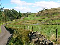
A small building, marked as a ruin in 1856 and now entirely absent, with its own entrance and sheep fauld, sat within woodland in line with the small loch and later substantial drainage ditch feature that runs down to the main loch. The larger
Lochlands Farm (NS378555) buildings lay closer to the
245:
Marked on
Ordnance Survey maps as 'The Lochs', it was locally known as the Lowes Loch and lies on the old 'Lowes Lands'. Four lochs may have once been present, a small one in front of Lows Cottage, a second along to the west of the surviving loch, and a smaller fourth one, now partly drained by a
437:
A small church may have been built here, possibly at the site of the original small
Lochlands building, which stood on the bank of a small loch, to 'counteract' the many pagan sites located at Cuff Hill, such as the lost 'Druid's Stone Circle, the Druids' Graves or Caves (a long barrow), the now
331:
Thomson's map of 1832 and the OS maps show that the loch flowed via the
Cadgerford Burn into the millpond of the old Threepwood Bleach and Dye works below Cuff Hill and thus helped to power the factory's waterwheel. Since at least 1891 the waters of the loch have flowed into the Kirkleegreen and
298:
The name of the inflow and outflow burn indicates, as stated, a ford on this old road once used by cadgers or carriers on horseback of goods, including items such as Dunlop cheeses. The burn is the existing inflow and outflow from Lowes Loch to the Dusk Water; it has been canalised and greatly
281:
lies above the site on the lower slopes of
Brownmuir or Brimmer Hill. This farm was occupied by the elderly couple, Mrs & Mrs Blair, at the time of the construction of Kirklee Green reservoir and was purchased upon their death by Ayrshire County Council and the roof removed.
327:
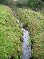
The lochan in front of Low
Cottage was a retting pond and the cottage was built as a retting cottage for the preparation of flax. The loch no longer has any open water. Retting is the process of taking off the outer part of flax by laying flax in water.
434:
of
Kirklee Green with its obvious religious links. It has not been seen since 1956. A small ruin was located to the west of Lochlands on the edge of a now drained lochan which is a candidate for the chapel site and the site of the aforementioned cross.
249:
The name 'Lowe' is said to have derived been from the Celtic for 'Hill' and
Lochlands Hill was once known as Lowes Hill. Before the Cadgerford Burn was deepened the lochs level would have been higher and may have once drained to the west and east.
438:
destroyed Four Stones, a standing stone, etc. The name Cuff itself has been interpreted as meaning Druid or Priest. Saint Inan's Well and Chair are close by and one of the hills in the area, marked as Krelig Hill, was once topped by a cross.
494:
Curling stones were produced at a site near Kirklee Green Reservoir for a number of years in the 19th century and it is said that a considerable number were used in the construction of the reservoir's dam.
299:
deepened to lower the level of Lowes Loch. The burn now flows into the Kirkleegreen Reservoir, built after 1858 and by 1891. The waters of this old reservoir, now an angling loch, run into
366:. Dugald was a hippy before hippies officially existed. He travelled widely to healthy living conferences in Norway, USA and elsewhere and died in Edinburgh aged 79. A regular visitor to
303:
and then into the Dusk Water via Threepwood Spout. The ford may have been where a culvert now carries the outflow of the small loch in front of Lows Cottage down towards Lowes Loch.
306:
Beith's annual fair, called Tennant's or Saint Tinnan's Day, was previously held on the Cuff Hill. It was famous for its show, and its Cadger's parade and sale of horses.
57:
872:
394:) breeds at the site. An extensive woodland of willow and birch extends towards Lowhouse Farmlands. Extensive areas of rushes (Juncus sps) are present.
105:
862:
465:
487:
It has been speculated that the Cuff Hill range was the Moor of Beith, and that this moor is the same as the "Wood of Belt" in which, at
444:
857:
785:
770:
189:
867:
852:
348:
Davie's o'the Mill is a probably an old flax mill associated with the retting cottage and possibly the bleach and dye works at
550:
382:
The relatively small area of open water is dominated by floating pondweeds (Potamogeton sps), and has some water lilies
574:
430:. It was demolished as part of precautions intended to prevent any possible contamination of the reservoir water.
520:
370:, he was known locally as the 'Bird Man' and was an enthusiast for outdoor living, publishing a book entitled
402:
692:
631:
423:
413:
162:
406:
349:
300:
278:
150:
229:, once of greater extent, lying below Brownmuir and Lochland Hills on the Threepwood Road, near
713:
781:
766:
226:
479:
340:
635:
314:
222:
174:
90:
41:
846:
647:
516:
387:
355:
137:
17:
383:
363:
271:
671:
586:
491:, a battle, supposed to have taken place in the latter half of the sixth century.
427:
367:
506:
835:
830:
825:
820:
815:
290:
832:
Commentary & video of Lochlands Farm and Lochan, Lowes Loch and the area.
515:
once serving The Cuff Farm below it. The site is rich in wildlife, including
120:
107:
362:
lived at Davie's o'the Mill from the 1930s until around 1950, when it was a
246:
deep ditch, sitting next to the older of the two Lochlands Farms ruins.
259:
151:
163:
505:
478:
401:
339:
289:
234:
230:
202:
86:
374:. He welcomed walkers and cyclists who often camped on his land.
143:
483:
Ancient ruins overlooking Lowes near the old Threepwood estate
628:
157:
Cadgerford and Lochlands Burns, field drainage, and rainfall
262:
cottage, later becoming a small farm with a byre attached.
498:
An old cheese press stone is located outside Low Cottage.
562:
237:. The loch may once have had a small island within it.
225:
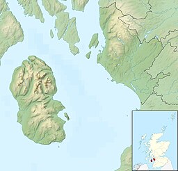
Council Areas (KA15 2JR), Scotland, lying in a glacial
827:
Video of the Threepwood Spout on the Cadgerford Burn.
417:
Seasonal lochan at Lochlands and the drainage ditch
198:
188:
184:
173:
161:
149:
136:
97:
82:
34:
795:Beith : Beith High Church Senior Youth Group.
98:
64:
822:Commentary & video of Cuff Hill Reservoir.
469:The location of The Lowes Loch, North Ayrshire
221:is now a small natural freshwater loch in the
817:Commentary & video of the Druid's Graves.
8:
46:Lowes loch from near the Lochlands Farm site
758:. Edinburgh : Edmonston & Douglas.
837:Video of Lochlands lochan and Lowes Lochs.
749:Cunninghame topographised by Timothy Pont.
31:
519:dragonflies. The rare climbing corydalis
169:Cadgerford Burn running to the Dusk Water
412:
313:
536:
667:
665:
7:
780:. Ochiltree : Stenlake Press.
597:
595:
546:
544:
542:
540:
360:Scottish Apostle of the simple life
873:Kettle lakes in the United Kingdom
451:
25:
450:
443:
344:Davie's o'the Mill ruins in 2011
63:
56:
40:
318:Old retting pond a Lows Cottage
270:Blaeu's map of 1684, pbased on
258:This building was originally a
1:
802:. London : Elliot Stock.
81:
863:Freshwater lochs of Scotland
523:grows amongst gorse nearby.
800:Prehistoric Man in Ayrshire
716:Retrieved : 2011-08-23
695:Retrieved : 2011-09-15
674:Retrieved ; 2011-09-05
650:Retrieved ; 2011-09-17
648:Scottish Vegetarian Society
638:Retrieved : 2011-08-23
589:Retrieved : 2011-08-24
577:Retrieved : 2011-08-24
565:Retrieved : 2011-08-24
553:Retrieved : 2011-08-24
889:
751:Glasgow : John Tweed.
335:
27:Lake in the United Kingdom
858:History of North Ayrshire
51:
39:
754:Glennie, J.S.S. (1869).
521:Ceratocapnos claviculata
868:Lakes of North Ayrshire
853:Lochs of North Ayrshire
372:A Free Man's Philosophy
71:Lowes Loch or The Lochs
35:Lowes Loch or The Lochs
511:
484:
418:
410:
409:in the Cadgerford Burn
345:
319:
295:
121:55.767250°N 4.587694°W
763:The Beith Supplement.
747:Dobie, James (1876).
509:
482:
426:which became part of
416:
405:
358:, vegetarian and the
343:
332:Cuffhill Reservoirs.
317:
293:
266:Cartographic evidence
798:Smith, John (1895).
756:Arthurian Localities
659:Reid (2000), Page 47
551:Antiquites. R. Love.
510:The Cuff Hill Lochan
489:the close of the day
466:class=notpageimage|
217:(NS 37754 55688) or
126:55.767250; -4.587694
18:Lowes Loch, Ayrshire
791:Reid, D.L. (2002).
776:Reid, D.L. (2000).
761:Reid, D.L. (2000).
294:The Cadgerford Burn
233:, in the Parish of
117: /
765:Beith : DoE.
634:2009-03-04 at the
512:
485:
419:
411:
346:
336:Davie's o'the Mill
320:
301:Cuffhill Reservoir
296:
390:or Sedge Darner (
208:
207:
16:(Redirected from
880:
735:
732:
726:
725:Glennie, Page 83
723:
717:
711:
705:
702:
696:
693:Cunningham Buses
690:
684:
681:
675:
669:
660:
657:
651:
645:
639:
626:
620:
617:
611:
608:
602:
599:
590:
584:
578:
572:
566:
560:
554:
548:
502:Cuff Hill Lochan
454:
453:
447:
165:
164:Primary outflows
153:
132:
131:
129:
128:
127:
122:
118:
115:
114:
113:
110:
100:
67:
66:
60:
44:
32:
21:
888:
887:
883:
882:
881:
879:
878:
877:
843:
842:
810:
805:
738:
733:
729:
724:
720:
712:
708:
703:
699:
691:
687:
682:
678:
670:
663:
658:
654:
646:
642:
636:Wayback Machine
627:
623:
619:Dobie, Page 324
618:
614:
610:Smith, Page 40.
609:
605:
600:
593:
585:
581:
573:
569:
561:
557:
549:
538:
529:
477:
472:
471:
470:
468:
462:
461:
460:
459:
455:
407:Marsh Pennywort
400:
398:Lochlands Farms
380:
378:Natural history
338:
312:
286:Cadgerford Burn
279:Rakerfield Farm
243:
177: countries
152:Primary inflows
125:
123:
119:
116:
111:
108:
106:
104:
103:
78:
77:
76:
75:
74:
73:
72:
68:
47:
28:
23:
22:
15:
12:
11:
5:
886:
884:
876:
875:
870:
865:
860:
855:
845:
844:
841:
840:
839:
838:
833:
828:
823:
818:
809:
808:External links
806:
804:
803:
796:
793:Beith Bygones.
789:
774:
759:
752:
744:
737:
736:
727:
718:
706:
704:Smith, Page 79
697:
685:
676:
661:
652:
640:
621:
612:
603:
591:
579:
567:
555:
535:
528:
525:
476:
473:
464:
463:
457:
456:
449:
448:
442:
441:
440:
399:
396:
379:
376:
337:
334:
325:
324:
311:
308:
277:The abandoned
242:
239:
223:North Ayrshire
206:
205:
200:
196:
195:
192:
186:
185:
182:
181:
178:
171:
170:
167:
159:
158:
155:
147:
146:
140:
134:
133:
101:
95:
94:
91:North Ayrshire
84:
80:
79:
70:
69:
62:
61:
55:
54:
53:
52:
49:
48:
45:
37:
36:
26:
24:
14:
13:
10:
9:
6:
4:
3:
2:
885:
874:
871:
869:
866:
864:
861:
859:
856:
854:
851:
850:
848:
836:
834:
831:
829:
826:
824:
821:
819:
816:
814:
813:
812:
811:
807:
801:
797:
794:
790:
787:
786:1-84033-126-7
783:
779:
775:
772:
771:0-9522720-1-6
768:
764:
760:
757:
753:
750:
746:
745:
743:
742:
734:Reid, Page 65
731:
728:
722:
719:
715:
710:
707:
701:
698:
694:
689:
686:
683:Reid, Page 52
680:
677:
673:
668:
666:
662:
656:
653:
649:
644:
641:
637:
633:
630:
625:
622:
616:
613:
607:
604:
601:Reid, Page 69
598:
596:
592:
588:
583:
580:
576:
575:Thomson's Map
571:
568:
564:
559:
556:
552:
547:
545:
543:
541:
537:
534:
533:
526:
524:
522:
518:
517:Common Hawker
508:
504:
503:
499:
496:
492:
490:
481:
475:Micro-history
474:
467:
446:
439:
435:
431:
429:
425:
415:
408:
404:
397:
395:
393:
392:Aeshna juncea
389:
388:Common Hawker
385:
377:
375:
373:
369:
365:
361:
357:
356:Dugald Semple
353:
351:
342:
333:
329:
322:
321:
316:
309:
307:
304:
302:
292:
288:
287:
283:
280:
275:
273:
268:
267:
263:
261:
256:
255:
251:
247:
240:
238:
236:
232:
228:
224:
220:
216:
212:
204:
201:
197:
193:
191:
187:
183:
179:
176:
172:
168:
166:
160:
156:
154:
148:
145:
141:
139:
135:
130:
102:
96:
92:
88:
85:
59:
50:
43:
38:
33:
30:
19:
799:
792:
777:
762:
755:
748:
740:
739:
730:
721:
709:
700:
688:
679:
655:
643:
624:
615:
606:
582:
570:
558:
531:
530:
513:
501:
500:
497:
493:
488:
486:
436:
432:
420:
391:
384:Nuphar lutea
381:
371:
364:smallholding
359:
354:
347:
330:
326:
323:Flax retting
305:
297:
285:
284:
276:
272:Timothy Pont
269:
265:
264:
257:
254:Lows Cottage
253:
252:
248:
244:
219:Loch of Hill
218:
214:
210:
209:
29:
428:Western SMT
368:Ailsa Craig
227:kettle hole
199:Settlements
142:Freshwater
124: /
112:4°35′15.7″W
109:55°46′2.1″N
99:Coordinates
847:Categories
527:References
458:Lowes Loch
350:Threepwood
241:Lochs site
211:Lowes Loch
93:, Scotland
778:Old Beith
563:Roy's Map
215:The Lochs
632:Archived
180:Scotland
83:Location
741:Sources
424:Paisley
260:retting
190:Islands
784:
769:
714:RCAHMS
672:OS Map
629:OS Map
587:OS Map
386:. The
532:Notes
235:Beith
231:Beith
203:Beith
175:Basin
87:Beith
782:ISBN
767:ISBN
310:Uses
144:loch
138:Type
849::
664:^
594:^
539:^
213:,
89:,
788:.
773:.
194:1
20:)
Text is available under the Creative Commons Attribution-ShareAlike License. Additional terms may apply.