58:
42:
511:
356:
65:
502:
via
Carmarthen Bay. The main channel has fluctuated from side to side of the estuary in the past; in the late 19th century, the Llanelli Port Authority obtained legislation permitting the construction of a training wall intended to confine it to the north side of the estuary; unfortunately, this
467:. Anyone can take a bucket of cockles for their personal use, but the commercial fishery is restricted to a relatively small number of licence holders. Cockle density fluctuates from year to year. The estuary is also an internationally important location for
623:, which was already used in a very sporadic way as an air-to-ground rocket range. The intention was to make way for a planned third London airport. The proposal was vigorously resisted locally and was dropped when another airport site was agreed.
302:. The river divides Carmarthenshire from Swansea for much of its course and it separates Hendy from Pontarddulais at the point where the river becomes tidal. The Loughor meets the sea at its estuary near the town of
1491:
432:
which enters on the Gower side near its mouth) is the region of the waterway below the road and rail bridges at
Loughor, where it turns abruptly from a southerly to a westerly direction towards
526:) to claim grazing land at the western end of the Gower side during the 1930s. This vigorous grass has since spread in a wide band all along the south side, forming the basis of a
1476:
607:
shells were tested against sheep in the estuary were finally substantiated in a reply to a parliamentary question from the late Tony Banks in
January 1987. In the 1960s, the
442:
empties into the estuary just below the
Loughor bridges. This region almost completely empties at low tide, exposing extensive sandy areas supporting a thriving
754:
788:
187:
347:
is currently undertaking studies into the possibility of constructing a barrage across the River
Loughor upstream from the Loughor bridges.
608:
1481:
57:
514:
561:
and is an area of sand dunes supporting several rare species. Just off the tip of the point is one of the few remaining cast-iron
1450:
760:
1496:
1324:
344:
781:
588:; quantities of unwanted munitions were also buried on the seaward side of this point. The area is regularly swept by the
1329:
741:
572:
several gun batteries were established to both the east and west of
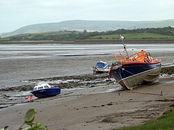
Penclawdd, where gun-barrels were calibrated and
1486:
997:
706:
668:"First Water Resources Survey : Report", South West Wales River Authority, Published 1970, Page 41; Table 1
1405:
774:
558:
1435:
1390:
472:
271:
129:
1415:
1282:
1420:
1400:
1303:
1241:
585:
504:
1236:
1005:
597:
1298:
1267:
604:
573:
451:
341:. The fishing declined in the 19th century due to increasing pollution from industrialisation.
1205:
1200:
1195:
1190:
1185:
1165:
1160:
1155:
1130:
1125:
1120:
1115:
1110:
1095:
1065:
1060:
1055:
1050:
1025:
1020:
1015:
1010:
683:
379:
1319:
1150:
906:
901:
896:
811:
522:
443:
227:
1105:
1100:
1045:
1035:
961:
831:
797:
499:
307:
263:
106:
41:
507:
but also of the
Penclawdd anchorage. The wall has since been breached in several places.
503:
merely dissipated the currents, accelerating the silting-up not only of the entrance to
1455:
1440:
1425:
1277:
1272:
1257:
1226:
577:
554:
510:
433:
338:
277:
251:
161:
143:
1470:
1385:
1334:
1262:
1231:
956:
951:
861:
593:
293:
1395:
1380:
1355:
931:
921:
871:
856:
826:
634:
616:
569:
321:
315:
306:
where it separates the south coast of
Carmarthenshire from the north coast of the
326:. The area of the catchment is some 262 square kilometres (101 sq mi).
1430:
1375:
1365:
1360:
1339:
1175:
1085:
1080:
1070:
977:
946:
881:
876:
866:
816:
581:
460:
311:
156:
17:
1445:
1410:
1370:
1170:
926:
911:
886:
589:
562:
548:
542:
527:
471:
and other wildfowl, which has led to demands from cocklers for the control of
520:
A later influence on the physical environment was the planting of cordgrass (
202:
189:
1221:
1140:
1075:
916:
891:
821:
553:
in
Carmarthenshire. This is now a National Nature Reserve maintained by the
536:
464:
283:
482:
The estuary cuts through the southern part of a once-important coalfield.
1180:
1135:
1090:
1030:
987:
941:
936:
620:
612:
495:
487:
483:
449:
On the south side of the inlet, the gathering and processing of cockles (
364:
533:
The estuary is partly closed off by
Whiteford Point, which extends from
355:
1145:
982:
711:
611:
proposed to move its main artillery and explosives testing facility at
601:
360:
303:
299:
282:
which translates from the Welsh as "eye of the Loughor". It flows past
267:
173:
110:
740:, ed. A. Nelson-Smith & E.M.Bridges, Institute of Marine Studies (
1040:
491:
456:
330:
337:
river. Fish from the river was then carried on ponies to be sold at
766:
678:
509:
468:
354:
334:
287:
259:
770:
455:) contributes significantly to the economy of the villages of
242:
239:
236:
490:
industry, whilst Penclawdd, on the south side, smelted
270:. The river is sourced from an underground lake at the
1492:
Sites of Special Scientific Interest in West Glamorgan
744:) & West Glamorgan County Council, Swansea, 1977.
530:
supporting the grazing of sheep, ponies and cattle.
233:
1348:
1312:
1291:
1250:
1214:
996:
970:
845:
804:
761:
Special Protection Area designation for the estuary
402:
394:
386:
377:
372:
230:
179:
167:
155:
135:
125:
116:
102:
94:
89:
77:
34:
565:, long since disused and in need of preservation.
782:
8:
600:are now recovered. Persistent rumours that
46:River Loughor just above the Loughor bridges
657:BBC Pronouncing Dictionary of British Names
632:
584:) were fired across the salt marsh towards
546:
534:
437:
329:In the 18th century, the river was a noted
319:
318:, with the former joining the Loughor near
291:
275:
141:
81:
1477:Rivers of the Brecon Beacons National Park
789:
775:
767:
486:, on its north shore, was noted for its
648:
369:
31:
401:
393:
385:
376:
64:
7:
707:"Anthrax (Hansard, 29 January 1987)"
498:. Both required ready access to the
619:, to a site between Burry Port and
25:
515:Whiteford National Nature Reserve
942:Rhossili Bay (Llangennith Sands)
226:
63:
56:
40:
1451:Audrey Williams (archaeologist)
712:Parliamentary Debates (Hansard)
310:. Among its tributaries is the
262:which marks the border between
27:River in Carmarthenshire, Wales
1325:Geology of the Gower Peninsula
345:Carmarthenshire County Council
181: • coordinates
1:
274:emerging at the surface from
117:Physical characteristics
1330:Gower Ornithological Society
576:(of various types including
742:University College, Swansea
738:Problems of a Small Estuary
359:Looking out to the Loughor
169: • location
137: • location
1513:
479:), which feed on cockles.
1482:Rivers of Carmarthenshire
755:Bury Inlet Cockle Fishery
686:Sites Information Service
659:(Oxford UP, 1971), p. 92.
633:
547:
535:
494:from ore shipped in from
438:
410:
320:
292:
276:
151:
142:
121:
51:
39:
1406:Will Jones (rugby union)
559:Natural Resources Wales
290:in Carmarthenshire and
1436:Mark Thomas (composer)
1391:Thomas Johnes (priest)
615:, at the mouth of the
517:
367:
255:
82:
1497:Ramsar sites in Wales
1416:John Myles (minister)
513:
477:Haematopus ostralegus
358:
1421:Red Lady of Paviland
1401:Kathleen Lloyd Jones
1304:Whiteford Lighthouse
1237:Parc Cwm long cairn
609:Ministry of Defence
596:team, although few
505:Llanelli North Dock
199: /
1299:Mumbles Lighthouse
1268:Oystermouth Castle
805:Geographical areas
763:, archived in 2008
757:, archived in 2003
605:biological warfare
518:
452:Cerastoderma edule
403:Reference no.
368:
1487:Rivers of Swansea
1464:
1463:
1215:Prehistoric sites
998:Villages in Gower
850:
715:. 29 January 1987
541:in Gower towards
428:, from the small
414:
413:
218:
217:
16:(Redirected from
1504:
1320:Cuisine of Gower
927:Port Eynon Beach
902:Three Cliffs Bay
849:listed clockwise
848:
791:
784:
777:
768:
725:
724:
722:
720:
703:
697:
696:
694:
692:
675:
669:
666:
660:
653:
638:
637:
552:
551:
540:
539:
523:Spartina anglica
441:
440:
370:
325:
324:
297:
296:
281:
280:
258:) is a river in
249:
248:
245:
244:
241:
238:
235:
232:
214:
213:
211:
210:
209:
204:
203:51.667°N 4.083°W
200:
197:
196:
195:
192:
147:
146:
138:
85:
67:
66:
60:
44:
32:
21:
1512:
1511:
1507:
1506:
1505:
1503:
1502:
1501:
1467:
1466:
1465:
1460:
1344:
1308:
1287:
1246:
1210:
992:
966:
962:Whiteford Sands
847:
841:
837:Loughor estuary
832:Fairwood Common
800:
798:Gower Peninsula
795:
751:
734:
729:
728:
718:
716:
705:
704:
700:
690:
688:
677:
676:
672:
667:
663:
654:
650:
645:
629:
586:Whiteford Point
500:Bristol Channel
418:Loughor Estuary
382:
353:
308:Gower Peninsula
264:Carmarthenshire
229:
225:
207:
205:
201:
198:
193:
190:
188:
186:
185:
182:
170:
136:
109:
107:Carmarthenshire
73:
72:
71:
70:
69:
68:
47:
28:
23:
22:
18:Loughor estuary
15:
12:
11:
5:
1510:
1508:
1500:
1499:
1494:
1489:
1484:
1479:
1469:
1468:
1462:
1461:
1459:
1458:
1456:C. Anne Wilson
1453:
1448:
1443:
1441:Vernon Watkins
1438:
1433:
1428:
1426:Colin Pressdee
1423:
1418:
1413:
1408:
1403:
1398:
1393:
1388:
1383:
1378:
1373:
1368:
1363:
1358:
1352:
1350:
1346:
1345:
1343:
1342:
1337:
1332:
1327:
1322:
1316:
1314:
1310:
1309:
1307:
1306:
1301:
1295:
1293:
1289:
1288:
1286:
1285:
1283:Weobley Castle
1280:
1278:Penrice Castle
1275:
1273:Pennard Castle
1270:
1265:
1260:
1258:Loughor Castle
1254:
1252:
1248:
1247:
1245:
1244:
1239:
1234:
1229:
1227:Long Hole Cave
1224:
1222:Arthur's Stone
1218:
1216:
1212:
1211:
1209:
1208:
1203:
1198:
1193:
1188:
1183:
1178:
1173:
1168:
1163:
1158:
1153:
1148:
1143:
1138:
1133:
1128:
1123:
1118:
1113:
1108:
1103:
1098:
1093:
1088:
1083:
1078:
1073:
1068:
1063:
1058:
1053:
1048:
1043:
1038:
1033:
1028:
1023:
1018:
1013:
1008:
1002:
1000:
994:
993:
991:
990:
985:
980:
974:
972:
968:
967:
965:
964:
959:
954:
949:
944:
939:
934:
929:
924:
919:
914:
909:
904:
899:
894:
889:
884:
879:
874:
869:
864:
859:
853:
851:
843:
842:
840:
839:
834:
829:
824:
819:
814:
808:
806:
802:
801:
796:
794:
793:
786:
779:
771:
765:
764:
758:
750:
749:External links
747:
746:
745:
733:
730:
727:
726:
698:
670:
661:
647:
646:
644:
641:
640:
639:
628:
625:
578:high-explosive
555:National Trust
473:oystercatchers
434:Carmarthen Bay
412:
411:
408:
407:
404:
400:
399:
396:
392:
391:
388:
384:
383:
380:Ramsar Wetland
378:
375:
374:
352:
349:
339:Swansea Market
278:Llygad Llwchwr
272:Black Mountain
216:
215:
208:51.667; -4.083
183:
180:
177:
176:
171:
168:
165:
164:
162:Carmarthen Bay
159:
153:
152:
149:
148:
144:Llygad Llwchwr
139:
133:
132:
130:Black Mountain
127:
123:
122:
119:
118:
114:
113:
104:
100:
99:
96:
92:
91:
87:
86:
79:
75:
74:
62:
61:
55:
54:
53:
52:
49:
48:
45:
37:
36:
26:
24:
14:
13:
10:
9:
6:
4:
3:
2:
1509:
1498:
1495:
1493:
1490:
1488:
1485:
1483:
1480:
1478:
1475:
1474:
1472:
1457:
1454:
1452:
1449:
1447:
1444:
1442:
1439:
1437:
1434:
1432:
1429:
1427:
1424:
1422:
1419:
1417:
1414:
1412:
1409:
1407:
1404:
1402:
1399:
1397:
1394:
1392:
1389:
1387:
1386:Nigel Jenkins
1384:
1382:
1379:
1377:
1374:
1372:
1369:
1367:
1364:
1362:
1359:
1357:
1354:
1353:
1351:
1347:
1341:
1338:
1336:
1335:Gower Wassail
1333:
1331:
1328:
1326:
1323:
1321:
1318:
1317:
1315:
1311:
1305:
1302:
1300:
1297:
1296:
1294:
1290:
1284:
1281:
1279:
1276:
1274:
1271:
1269:
1266:
1264:
1263:Oxwich Castle
1261:
1259:
1256:
1255:
1253:
1249:
1243:
1242:Paviland Cave
1240:
1238:
1235:
1233:
1232:Parc le Breos
1230:
1228:
1225:
1223:
1220:
1219:
1217:
1213:
1207:
1204:
1202:
1201:Three Crosses
1199:
1197:
1194:
1192:
1189:
1187:
1184:
1182:
1179:
1177:
1174:
1172:
1169:
1167:
1164:
1162:
1159:
1157:
1154:
1152:
1149:
1147:
1144:
1142:
1139:
1137:
1134:
1132:
1129:
1127:
1124:
1122:
1119:
1117:
1114:
1112:
1109:
1107:
1104:
1102:
1099:
1097:
1094:
1092:
1089:
1087:
1084:
1082:
1079:
1077:
1074:
1072:
1069:
1067:
1064:
1062:
1059:
1057:
1054:
1052:
1049:
1047:
1044:
1042:
1039:
1037:
1034:
1032:
1029:
1027:
1024:
1022:
1019:
1017:
1014:
1012:
1009:
1007:
1004:
1003:
1001:
999:
995:
989:
986:
984:
981:
979:
976:
975:
973:
969:
963:
960:
958:
957:Broughton Bay
955:
953:
952:Blue Pool Bay
950:
948:
945:
943:
940:
938:
935:
933:
930:
928:
925:
923:
920:
918:
915:
913:
910:
908:
905:
903:
900:
898:
895:
893:
890:
888:
885:
883:
880:
878:
875:
873:
870:
868:
865:
863:
862:Limeslade Bay
860:
858:
855:
854:
852:
844:
838:
835:
833:
830:
828:
825:
823:
820:
818:
815:
813:
812:Bishop's Wood
810:
809:
807:
803:
799:
792:
787:
785:
780:
778:
773:
772:
769:
762:
759:
756:
753:
752:
748:
743:
739:
736:
735:
731:
714:
713:
708:
702:
699:
687:
685:
680:
679:"Burry Inlet"
674:
671:
665:
662:
658:
655:G.M. Miller,
652:
649:
642:
636:
631:
630:
626:
624:
622:
618:
614:
610:
606:
603:
599:
595:
594:bomb disposal
591:
587:
583:
579:
575:
571:
566:
564:
560:
556:
550:
544:
538:
531:
529:
525:
524:
516:
512:
508:
506:
501:
497:
493:
489:
485:
480:
478:
474:
470:
466:
462:
458:
454:
453:
447:
445:
435:
431:
427:
426:Burry estuary
423:
419:
409:
405:
397:
389:
387:Official name
381:
371:
366:
362:
357:
350:
348:
346:
342:
340:
336:
332:
327:
323:
317:
316:River Morlais
313:
309:
305:
301:
295:
294:Pontarddulais
289:
285:
279:
273:
269:
265:
261:
257:
253:
247:
223:
222:River Loughor
212:
184:
178:
175:
172:
166:
163:
160:
158:
154:
150:
145:
140:
134:
131:
128:
124:
120:
115:
112:
108:
105:
101:
97:
93:
88:
84:
80:
76:
59:
50:
43:
38:
35:River Loughor
33:
30:
19:
1396:Ernest Jones
1381:Karl Jenkins
1356:Byron Davies
1206:Upper Killay
1166:Pitton Green
1131:Oxwich Green
932:Mewslade Bay
922:Horton Beach
872:Langland Bay
857:Bracelet Bay
836:
827:Clyne Common
737:
717:. Retrieved
710:
701:
689:. Retrieved
682:
673:
664:
656:
651:
635:Aber Llwchwr
617:River Thames
570:World War II
567:
532:
521:
519:
481:
476:
450:
448:
429:
425:
421:
417:
415:
398:14 July 1992
373:Designations
343:
328:
322:Pantyffynnon
256:Afon Llwchwr
221:
219:
83:Afon Llwchwr
29:
1431:Phil Tanner
1376:Cyril Gwynn
1366:Edgar Evans
1361:Ifor Davies
1340:Ilston Book
1292:Lighthouses
1176:Reynoldston
1111:Nicholaston
1086:Llanrhidian
1081:Llanmorlais
1071:Llangennith
1011:Burry Green
978:Burry Holms
947:Burry Holms
897:Pobbles Bay
882:Brandy Cove
877:Caswell Bay
867:Rotherslade
817:Burry Holms
582:mustard gas
563:lighthouses
461:Llanmorlais
430:Burry River
422:Burry inlet
390:Burry Inlet
312:River Amman
206: /
78:Native name
1471:Categories
1446:Harri Webb
1411:Jo Mazelis
1371:Iris Gower
1171:Port Eynon
1006:Bishopston
912:Oxwich Bay
887:Pwlldu Bay
643:References
590:Royal Navy
549:Cefn Sidan
543:Burry Port
528:salt-marsh
446:industry.
395:Designated
1196:Southgate
1141:Penclawdd
1096:Middleton
1076:Llanmadoc
1066:Llanddewi
1056:Landimore
971:Headlands
917:Slade Bay
892:Hunts Bay
822:Cefn Bryn
537:Llanmadoc
465:Penclawdd
439:Afon Lliw
284:Ammanford
1191:Scurlage
1181:Rhossili
1136:Parkmill
1116:Oldwalls
1091:Llethryd
1061:Langland
1051:Knelston
1031:Gowerton
1021:Cheriton
988:Rhossili
937:Fall Bay
691:25 April
627:See also
621:Kidwelly
613:Foulness
496:Anglesey
488:tinplate
484:Llanelli
365:Rhossili
333:and sea
314:and the
103:Counties
90:Location
1251:Castles
1156:Penrice
1151:Penmaen
1146:Pennard
1121:Overton
1016:Caswell
983:Mumbles
907:Tor Bay
846:Beaches
732:Sources
602:anthrax
568:During
361:estuary
351:Estuary
304:Loughor
300:Swansea
268:Swansea
191:51°40′N
174:Loughor
111:Swansea
95:Country
1349:People
1161:Pitton
1126:Oxwich
1106:Newton
1101:Murton
1046:Kittle
1041:Ilston
1036:Horton
1026:Crofty
719:2 June
684:Ramsar
598:shells
574:shells
492:copper
469:waders
457:Crofty
444:cockle
436:. The
331:salmon
194:4°05′W
126:Source
1313:Other
1186:Slade
420:(aka
363:from
335:trout
288:Hendy
260:Wales
252:Welsh
157:Mouth
98:Wales
721:2015
693:2018
580:and
557:and
545:and
463:and
416:The
286:and
266:and
220:The
592:'s
424:or
406:562
298:in
250:) (
1473::
709:.
681:.
459:,
254::
243:ər
790:e
783:t
776:v
723:.
695:.
475:(
246:/
240:x
237:ʌ
234:l
231:ˈ
228:/
224:(
20:)
Text is available under the Creative Commons Attribution-ShareAlike License. Additional terms may apply.