40:
647:
84:
65:
55:
153:
91:
623:
355:
Rychmburk Castle was probably built in the early 13th century. In the first half of the 14th century, it was rebuilt and extended. In 1530–1540, it was rebuilt in the
Renaissance style. Among its owners belonged Lords of Waldstein (1500–1555), Berka of Dubá family (1555–1709), House of
658:
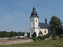
The main sight of the village is the Church of Our Lady of
Sorrows. It was built in 1753. Opposite the church is the manor garden with a gazebo and a bust of Philipp Kinsky (1742–1827), the founder of the garden and the owner of the manor for more than 50 years.
654:
Rychmburk Castle is the main landmark of Předhradí. Today the premises partly serves as retirement house. There is also an exposition of the history of the castle, a chapel, a concert hall, and a castle tower open to the public.
773:
347:. The highest point is at 506 m (1,660 ft) above sea level. The municipality is situated on the left bank of the Krounka River, which forms the eastern municipal border.
879:
39:
83:
1505:
1122:
115:
320:
1199:
1189:
1112:
1261:
1102:
1082:
1432:
344:
177:
1117:
319:. It has about 400 inhabitants. The historic centre with the Rychmburk Castle is well preserved and is protected by law as an
64:
872:
1462:
1452:
1356:
1273:
1194:
1184:
1137:
1107:
1077:
1035:
1030:
165:
918:
269:
54:
1351:
1167:
339:
Předhradí is located about 21 kilometres (13 mi) southeast of
Chrudim and 29 km (18 mi) southeast of
1366:
1283:
1173:
1157:
1132:
1472:
1311:
1300:
1226:
1162:
1142:
1092:
950:
865:
1050:
1011:
781:
759:
693:
1477:
1017:
1278:
1221:
248:
1241:
1179:
857:
689:
996:
258:
799:
646:
1442:
1294:
755:
1410:
1066:
960:
1379:
1060:
902:
312:
308:
182:
170:
1372:
1346:
1147:
819:
361:
1385:
1055:
935:
1416:
1405:
1400:
1209:
1006:
316:
158:
734:
710:
1499:
1152:
973:
668:
1395:
1336:
1325:
1087:
991:
986:
955:
1467:
1447:
1422:
1246:
1204:
923:
913:
893:
1483:
1437:
1427:
1288:
1251:
1236:
1097:
1072:
1040:
1001:
795:
130:
117:
1390:
1361:
1305:
340:
239:
1457:
1331:
1318:
1267:
940:
635:
1215:
1341:
1231:
1045:
1024:
980:
929:
898:
631:
367:
The first written mention of the settlement of Předhradí is from 1654.
622:
1127:
966:
945:
357:
265:
244:
645:
621:
888:
545:
469:
393:
30:
861:
845:
540:
464:
388:
291:
331:
The hamlet of Dolívka is administrative part of Předhradí.
852:
756:"Historický lexikon obcí České republiky 1869–2011"
286:
276:
255:
238:
230:
222:
217:
209:
201:
196:
188:
176:
164:
146:
21:
690:"Population of Municipalities – 1 January 2024"
873:
8:
375:
774:"Population Census 2021: Population by sex"
880:
866:
858:
374:
18:
630:Předhradí is located on the railway line
16:Municipality in Pardubice, Czech Republic
705:
703:
343:. It lies in an elevated plateau in the
681:
285:
275:
237:
216:
208:
195:
187:
145:
110:
76:
48:
36:
729:
727:
254:
229:
221:
200:
175:
163:
7:
205:8.33 km (3.22 sq mi)
14:
307:is a municipality and village in
90:
151:
89:
82:
63:
53:
38:
103:Location in the Czech Republic
1:
650:Church of Our Lady of Sorrows
1506:Villages in Chrudim District
822:(in Czech). Rychmburk Castle
713:(in Czech). Rychmburk Castle
1113:Kostelec u Heřmanova Městce
1522:
796:"Detail stanice Předhradí"
737:(in Czech). Obec Předhradí
379:
360:(1718–1823), and House of
213:420 m (1,380 ft)
909:
610:
406:—
111:
77:
49:
37:
28:
782:Czech Statistical Office
760:Czech Statistical Office
694:Czech Statistical Office
651:
627:
234:48/km (120/sq mi)
649:
625:
376:Historical population
257: • Summer (
131:49.83167°N 16.03833°E
327:Administrative parts
231: • Density
1295:Ronov nad Doubravou
377:
321:urban monument zone
127: /
44:Centre of Předhradí
1478:Žlebské Chvalovice
1242:Podhořany u Ronova
652:
628:
223: • Total
202: • Total
136:49.83167; 16.03833
1493:
1492:
1279:Rabštejnská Lhota
820:"Hradní expozice"
671:(1835–1923), poet
615:
614:
606:
605:
530:
529:
454:
453:
302:
301:
1513:
1443:Vrbatův Kostelec
903:Chrudim District
882:
875:
868:
859:
853:Rychmburk Castle
849:
848:
846:Official website
831:
830:
828:
827:
816:
810:
809:
807:
806:
792:
786:
785:
770:
764:
763:
752:
746:
745:
743:
742:
731:
722:
721:
719:
718:
707:
698:
697:
686:
626:Rychmburk Castle
611:Source: Censuses
547:
542:
534:
533:
471:
466:
458:
457:
395:
390:
382:
381:
378:
313:Pardubice Region
309:Chrudim District
298:
295:
293:
262:
157:
155:
154:
142:
141:
139:
138:
137:
132:
128:
125:
124:
123:
120:
93:
92:
86:
67:
57:
42:
19:
1521:
1520:
1516:
1515:
1514:
1512:
1511:
1510:
1496:
1495:
1494:
1489:
1380:Trhová Kamenice
1018:Heřmanův Městec
905:
886:
844:
843:
840:
835:
834:
825:
823:
818:
817:
813:
804:
802:
794:
793:
789:
778:Public Database
772:
771:
767:
754:
753:
749:
740:
738:
735:"Historie obce"
733:
732:
725:
716:
714:
709:
708:
701:
688:
687:
683:
678:
665:
644:
636:Žďárec u Skutče
620:
373:
362:Thurn und Taxis
353:
337:
329:
290:
282:
256:
189:First mentioned
152:
150:
135:
133:
129:
126:
121:
118:
116:
114:
113:
107:
106:
105:
104:
101:
100:
99:
98:
94:
73:
72:
71:
70:
61:
60:
45:
33:
24:
17:
12:
11:
5:
1519:
1517:
1509:
1508:
1498:
1497:
1491:
1490:
1488:
1487:
1480:
1475:
1470:
1465:
1460:
1455:
1450:
1445:
1440:
1435:
1430:
1425:
1420:
1413:
1408:
1403:
1398:
1393:
1388:
1383:
1376:
1369:
1364:
1359:
1354:
1349:
1344:
1339:
1334:
1329:
1322:
1315:
1308:
1303:
1298:
1291:
1286:
1281:
1276:
1271:
1264:
1259:
1254:
1249:
1244:
1239:
1234:
1229:
1224:
1219:
1212:
1207:
1202:
1197:
1192:
1187:
1182:
1177:
1170:
1165:
1160:
1155:
1150:
1145:
1140:
1135:
1130:
1125:
1120:
1115:
1110:
1105:
1100:
1095:
1090:
1085:
1080:
1075:
1070:
1063:
1058:
1053:
1048:
1043:
1038:
1033:
1028:
1021:
1014:
1009:
1004:
999:
997:Dolní Bezděkov
994:
989:
984:
977:
970:
963:
958:
953:
948:
943:
938:
933:
926:
921:
916:
910:
907:
906:
887:
885:
884:
877:
870:
862:
856:
855:
850:
839:
838:External links
836:
833:
832:
811:
787:
765:
747:
723:
699:
680:
679:
677:
674:
673:
672:
664:
663:Notable people
661:
643:
640:
619:
616:
613:
612:
608:
607:
604:
603:
600:
597:
593:
592:
589:
586:
582:
581:
578:
575:
571:
570:
567:
564:
560:
559:
556:
553:
549:
548:
543:
538:
531:
528:
527:
524:
521:
517:
516:
513:
510:
506:
505:
502:
499:
495:
494:
491:
488:
484:
483:
480:
477:
473:
472:
467:
462:
455:
452:
451:
448:
445:
441:
440:
437:
434:
430:
429:
426:
423:
419:
418:
415:
412:
408:
407:
404:
401:
397:
396:
391:
386:
372:
369:
352:
349:
345:Iron Mountains
336:
333:
328:
325:
317:Czech Republic
300:
299:
288:
284:
283:
281:539 73, 539 74
280:
278:
274:
273:
263:
253:
252:
242:
236:
235:
232:
228:
227:
224:
220:
219:
215:
214:
211:
207:
206:
203:
199:
198:
194:
193:
190:
186:
185:
180:
174:
173:
168:
162:
161:
159:Czech Republic
148:
144:
143:
109:
108:
102:
96:
95:
88:
87:
81:
80:
79:
78:
75:
74:
68:
62:
58:
52:
51:
50:
47:
46:
43:
35:
34:
29:
26:
25:
22:
15:
13:
10:
9:
6:
4:
3:
2:
1518:
1507:
1504:
1503:
1501:
1486:
1485:
1481:
1479:
1476:
1474:
1471:
1469:
1466:
1464:
1461:
1459:
1456:
1454:
1451:
1449:
1446:
1444:
1441:
1439:
1436:
1434:
1431:
1429:
1426:
1424:
1421:
1419:
1418:
1414:
1412:
1411:Vápenný Podol
1409:
1407:
1404:
1402:
1399:
1397:
1394:
1392:
1389:
1387:
1384:
1382:
1381:
1377:
1375:
1374:
1370:
1368:
1365:
1363:
1360:
1358:
1355:
1353:
1350:
1348:
1345:
1343:
1340:
1338:
1335:
1333:
1330:
1328:
1327:
1323:
1321:
1320:
1316:
1314:
1313:
1309:
1307:
1304:
1302:
1299:
1297:
1296:
1292:
1290:
1287:
1285:
1282:
1280:
1277:
1275:
1272:
1270:
1269:
1265:
1263:
1260:
1258:
1255:
1253:
1250:
1248:
1245:
1243:
1240:
1238:
1235:
1233:
1230:
1228:
1225:
1223:
1220:
1218:
1217:
1213:
1211:
1208:
1206:
1203:
1201:
1198:
1196:
1193:
1191:
1188:
1186:
1183:
1181:
1178:
1176:
1175:
1171:
1169:
1166:
1164:
1161:
1159:
1156:
1154:
1151:
1149:
1146:
1144:
1141:
1139:
1136:
1134:
1131:
1129:
1126:
1124:
1121:
1119:
1116:
1114:
1111:
1109:
1106:
1104:
1101:
1099:
1096:
1094:
1091:
1089:
1086:
1084:
1081:
1079:
1076:
1074:
1071:
1069:
1068:
1067:Hrochův Týnec
1064:
1062:
1059:
1057:
1054:
1052:
1049:
1047:
1044:
1042:
1039:
1037:
1034:
1032:
1029:
1027:
1026:
1022:
1020:
1019:
1015:
1013:
1010:
1008:
1005:
1003:
1000:
998:
995:
993:
990:
988:
985:
983:
982:
978:
976:
975:
971:
969:
968:
964:
962:
961:České Lhotice
959:
957:
954:
952:
949:
947:
944:
942:
939:
937:
934:
932:
931:
927:
925:
922:
920:
917:
915:
912:
911:
908:
904:
900:
896:
895:
890:
883:
878:
876:
871:
869:
864:
863:
860:
854:
851:
847:
842:
841:
837:
821:
815:
812:
801:
797:
791:
788:
784:. 2021-03-27.
783:
779:
775:
769:
766:
762:. 2015-12-21.
761:
757:
751:
748:
736:
730:
728:
724:
712:
706:
704:
700:
696:. 2024-05-17.
695:
691:
685:
682:
675:
670:
667:
666:
662:
660:
656:
648:
641:
639:
637:
633:
624:
617:
609:
601:
598:
595:
594:
590:
587:
584:
583:
579:
576:
573:
572:
568:
565:
562:
561:
557:
554:
551:
550:
544:
539:
536:
535:
532:
525:
522:
519:
518:
514:
511:
508:
507:
503:
500:
497:
496:
492:
489:
486:
485:
481:
478:
475:
474:
468:
463:
460:
459:
456:
449:
446:
443:
442:
438:
435:
432:
431:
427:
424:
421:
420:
416:
413:
410:
409:
405:
402:
399:
398:
392:
387:
384:
383:
380:
370:
368:
365:
364:(1823–1918).
363:
359:
350:
348:
346:
342:
334:
332:
326:
324:
322:
318:
314:
310:
306:
297:
289:
279:
271:
267:
264:
260:
250:
246:
243:
241:
233:
225:
212:
204:
191:
184:
181:
179:
172:
169:
167:
160:
149:
140:
112:Coordinates:
85:
66:
56:
41:
32:
27:
20:
1482:
1415:
1378:
1371:
1324:
1317:
1310:
1293:
1266:
1256:
1214:
1180:Míčov-Sušice
1172:
1065:
1056:Horní Bradlo
1023:
1016:
979:
974:Chroustovice
972:
965:
936:Bor u Skutče
928:
894:market towns
892:
824:. Retrieved
814:
803:. Retrieved
798:(in Czech).
790:
777:
768:
758:(in Czech).
750:
739:. Retrieved
715:. Retrieved
684:
669:Adolf Heyduk
657:
653:
629:
371:Demographics
366:
354:
338:
330:
304:
303:
277:Postal codes
69:Coat of arms
31:Municipality
1423:Vejvanovice
1190:Mladoňovice
1123:Křižanovice
1061:Hošťalovice
1007:Dvakačovice
800:České dráhy
134: /
1373:Třemošnice
1347:Střemošice
1262:Přestavlky
1252:Prachovice
1153:Licibořice
1148:Liboměřice
1083:Jenišovice
1073:Hroubovice
826:2021-10-19
805:2023-11-13
741:2021-10-19
717:2021-10-19
711:"Historie"
676:References
294:.predhradi
218:Population
119:49°49′54″N
1433:Vojtěchov
1396:Tuněchody
1391:Trojovice
1386:Třibřichy
1362:Svratouch
1337:Sobětuchy
1326:Slatiňany
1306:Rozhovice
1257:Předhradí
1088:Kameničky
956:Čankovice
919:Biskupice
618:Transport
341:Pardubice
335:Geography
305:Předhradí
240:Time zone
210:Elevation
171:Pardubice
122:16°2′18″E
97:Předhradí
23:Předhradí
1500:Category
1468:Zájezdec
1463:Zaječice
1453:Vysočina
1448:Všeradov
1417:Včelákov
1406:Úhřetice
1401:Úherčice
1357:Svídnice
1352:Studnice
1274:Prosetín
1247:Pokřikov
1216:Nasavrky
1210:Načešice
1205:Nabočany
1200:Mrákotín
1195:Morašice
1185:Miřetice
1168:Lukavice
1138:Leštinka
924:Bítovany
914:Běstvina
899:villages
178:District
1484:Žumberk
1438:Vortová
1428:Vítanov
1367:Tisovec
1342:Stolany
1289:Řestoky
1237:Perálec
1232:Otradov
1158:Lipovec
1103:Kněžice
1098:Klešice
1078:Jeníkov
1046:Honbice
1041:Holetín
1036:Hodonín
1031:Hluboká
1025:Hlinsko
1002:Dřenice
981:Chrudim
930:Bojanov
632:Svitavy
351:History
315:of the
311:in the
287:Website
183:Chrudim
147:Country
1473:Zderaz
1458:Vyžice
1332:Smrček
1319:Skuteč
1301:Rosice
1268:Proseč
1227:Ostrov
1163:Lozice
1143:Libkov
1128:Krouna
1118:Krásné
1093:Kladno
992:Dědová
987:Ctětín
967:Chrast
951:Bylany
946:Bousov
941:Bořice
642:Sights
602:−15.5%
526:−10.3%
515:+25.3%
504:−19.2%
482:−12.7%
439:+14.3%
358:Kinsky
166:Region
156:
1051:Horka
1012:Hamry
889:Towns
591:−4.9%
580:−9.3%
569:−6.1%
558:+4.2%
493:−7.2%
450:−5.5%
428:+0.0%
417:+3.8%
266:UTC+2
245:UTC+1
1284:Raná
1222:Orel
1174:Luže
1133:Lány
1108:Kočí
897:and
596:2021
585:2011
574:2001
563:1991
552:1980
541:Pop.
537:Year
520:1970
509:1961
498:1950
487:1930
476:1921
465:Pop.
461:Year
444:1910
433:1900
422:1890
411:1880
400:1869
389:Pop.
385:Year
270:CEST
197:Area
192:1325
59:Flag
1312:Seč
901:of
599:361
588:427
577:449
566:495
555:527
523:506
512:564
501:450
490:557
479:600
447:687
436:727
425:636
414:636
403:613
323:.
296:.cz
292:www
259:DST
249:CET
226:397
1502::
891:,
780:.
776:.
726:^
702:^
692:.
638:.
546:±%
470:±%
394:±%
881:e
874:t
867:v
829:.
808:.
744:.
720:.
634:–
272:)
268:(
261:)
251:)
247:(
Text is available under the Creative Commons Attribution-ShareAlike License. Additional terms may apply.