168:
187:
156:
26:
140:
has a military-run antenna complex on the summit. It is a very popular mountain to climb. There is a walking route to the summit from the south, various scrambling routes from a high col to the north, marked with small cairns and red dots painted on rocks, and an easy scrambling route which starts
141:
slightly lower down on the south west side of the col. The summit is unusual in having a deep pit which appears to have been formed by limestone dissolution (see
224:
55:
248:
253:
145:) which was said to have been used for storing snow in the past. There are several ruins on a col near the summit which used to be snow houses (see
217:
167:
243:
48:
210:
155:
146:
136:
mountains. It is the highest peak on the island whose summit is accessible, as its higher neighbour
133:
113:
186:
194:
106:
237:
137:
70:
57:
129:
95:
25:
38:
142:
125:
99:
193:
This article about a location in the
Balearic Islands is a
198:
105:
91:
86:
47:
37:
32:
18:
218:
8:
225:
211:
15:
151:
7:
183:
181:
197:. You can help Knowledge (XXG) by
124:is the second highest peak on the
14:
249:Mountains of the Balearic Islands
254:Balearic Islands geography stubs
185:
166:
154:
24:
1:
43:1,364 m (4,475 ft)
270:
180:
23:
132:. It is situated in the
244:Mountains of Mallorca
173:View from the summit
147:Ice_house_(building)
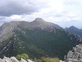
161:Peak from southeast
134:Serra de Tramuntana
114:Serra de Tramuntana
67: /
122:Puig de Massanella
33:Highest point
19:Puig de Massanella
206:
205:
119:
118:
261:
227:
220:
213:
189:
182:
170:
158:
109:
82:
81:
79:
78:
77:
72:
71:39.800°N 2.850°E
68:
65:
64:
63:
60:
28:
16:
269:
268:
264:
263:
262:
260:
259:
258:
234:
233:
232:
231:
178:
174:
171:
162:
159:
107:
75:
73:
69:
66:
61:
58:
56:
54:
53:
12:
11:
5:
267:
265:
257:
256:
251:
246:
236:
235:
230:
229:
222:
215:
207:
204:
203:
190:
176:
175:
172:
165:
163:
160:
153:
117:
116:
111:
103:
102:
93:
89:
88:
84:
83:
51:
45:
44:
41:
35:
34:
30:
29:
21:
20:
13:
10:
9:
6:
4:
3:
2:
266:
255:
252:
250:
247:
245:
242:
241:
239:
228:
223:
221:
216:
214:
209:
208:
202:
200:
196:
191:
188:
184:
179:
169:
164:
157:
152:
150:
148:
144:
139:
135:
131:
127:
123:
115:
112:
110:
104:
101:
97:
94:
90:
85:
80:
76:39.800; 2.850
52:
50:
46:
42:
40:
36:
31:
27:
22:
17:
199:expanding it
192:
177:
121:
120:
108:Parent range
74: /
49:Coordinates
238:Categories
138:Puig Major
128:island of
87:Geography
39:Elevation
130:Mallorca
96:Mallorca
92:Location
126:Spanish
59:39°48′N
62:2°51′E
143:Karst
100:Spain
195:stub
149:).
240::
98:,
226:e
219:t
212:v
201:.
Text is available under the Creative Commons Attribution-ShareAlike License. Additional terms may apply.