31:
44:
51:
187:
368:
The local mine working beneath the village, known locally as 'Dan's Muck Hole' (sunk in 1875 and closed in 1948) was one of the most shallow in the area, sunk at a depth of only 45 yards, it was a deep mine in all but name. The legacy of its working were a lot of subsidence in the area and as a
372:
The main place of worship in the area is the prominent
Bethany Baptist Church sited along the banks of the river. Also further south towards the town centre is Mill Street School (today Ysgol Gynradd Gymraeg Evan James).
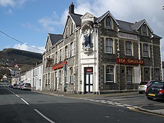
365:, in as far as he was said to have been helped across a ford in the river here and blessed the area with good fortune. The impressive structure of the local pub (The Merlin) bears his name.
369:
result many homes were affected. The entrance to the old pit can still be seen behind the home stand at Sardis Road rugby football ground, and is also commemorated by a nearby coal dram.
227:
253:
211:
82:
245:
30:
43:
235:
173:
451:
281:
204:
199:
289:
271:
161:
127:
75:
415:
109:
91:
141:
276:
216:
192:
99:
64:
166:
361:(or as it is colloquially named the "House of Pain"). Also the area has a connection with
390:
445:
342:
117:
358:
354:
330:
423:
326:
304:
291:
338:
151:
353:
Pwllgwaun for such a small area is quite famous, in that it is the home of
334:
362:
133:
345:. It consists largely of mining terrace type housing.
341:above, and is located along the banks of the river
244:
226:
210:
198:
186:
172:
160:
150:
140:
126:
108:
90:
74:
23:
329:within the 'Rhondda' electoral ward, bordered by
325:(or Pwll-Gwaun) is a village and small suburb of
337:hill to the north and east, the hillsides of
8:
20:
382:
225:
181:
149:
125:
73:
27:
243:
209:
197:
185:
171:
159:
139:
107:
89:
7:
357:in Pontypridd with the home ground,
14:
50:
349:Buildings and structures of note
49:
42:
29:
246:Senedd Cymru – Welsh Parliament
1:
452:Villages in Rhondda Cynon Taf
416:"Pwllgwaun Colliery Memorial"
76:OS grid reference
468:
262:
222:
182:
37:
28:
18:Human settlement in Wales
162:Postcode district
110:Preserved county
395:welshcoalmines.co.uk
391:"Pwllgwaun Colliery"
305:51.60335°N 3.34932°W
142:Sovereign state
301: /
92:Principal area
310:51.60335; -3.34932
228:UK Parliament
174:Dialling code
320:
319:
282:Rhondda Cynon Taf
100:Rhondda Cynon Taf
65:Rhondda Cynon Taf
459:
436:
435:
433:
431:
422:. Archived from
412:
406:
405:
403:
401:
387:
316:
315:
313:
312:
311:
306:
302:
299:
298:
297:
294:
268:
136:
86:
85:
63:Location within
53:
52:
46:
33:
21:
467:
466:
462:
461:
460:
458:
457:
456:
442:
441:
440:
439:
429:
427:
426:on 3 April 2016
414:
413:
409:
399:
397:
389:
388:
384:
379:
351:
309:
307:
303:
300:
295:
292:
290:
288:
287:
286:
266:
258:
240:
132:
122:
104:
81:
80:
70:
69:
68:
67:
61:
60:
59:
58:
54:
19:
12:
11:
5:
465:
463:
455:
454:
444:
443:
438:
437:
407:
381:
380:
378:
375:
350:
347:
318:
317:
285:
284:
279:
274:
269:
267:List of places
263:
260:
259:
257:
256:
250:
248:
242:
241:
239:
238:
232:
230:
224:
223:
220:
219:
214:
208:
207:
202:
196:
195:
190:
184:
183:
180:
179:
176:
170:
169:
164:
158:
157:
154:
148:
147:
146:United Kingdom
144:
138:
137:
130:
124:
123:
121:
120:
114:
112:
106:
105:
103:
102:
96:
94:
88:
87:
78:
72:
71:
62:
56:
55:
48:
47:
41:
40:
39:
38:
35:
34:
26:
25:
17:
13:
10:
9:
6:
4:
3:
2:
464:
453:
450:
449:
447:
425:
421:
417:
411:
408:
396:
392:
386:
383:
376:
374:
370:
366:
364:
360:
356:
348:
346:
344:
343:River Rhondda
340:
336:
332:
328:
324:
314:
283:
280:
278:
275:
273:
270:
265:
264:
261:
255:
252:
251:
249:
247:
237:
234:
233:
231:
229:
221:
218:
215:
213:
206:
203:
201:
194:
191:
189:
177:
175:
168:
165:
163:
155:
153:
145:
143:
135:
131:
129:
119:
118:Mid Glamorgan
116:
115:
113:
111:
101:
98:
97:
95:
93:
84:
79:
77:
66:
45:
36:
32:
22:
16:
428:. Retrieved
424:the original
419:
410:
398:. Retrieved
394:
385:
371:
367:
352:
322:
321:
15:
420:pmsa.org.uk
359:Sardis Road
331:Hopkinstown
308: /
205:South Wales
193:South Wales
327:Pontypridd
293:51°36′12″N
254:Pontypridd
236:Pontypridd
156:PONTYPRIDD
339:Maesycoed
323:Pwllgwaun
296:3°20′58″W
212:Ambulance
152:Post town
57:Pwllgwaun
24:Pwllgwaun
446:Category
430:22 March
400:22 March
335:Graigwen
128:Country
363:Merlin
188:Police
83:ST0690
377:Notes
355:rugby
277:Wales
217:Welsh
178:01443
134:Wales
432:2016
402:2016
333:and
200:Fire
167:CF37
448::
418:.
393:.
272:UK
434:.
404:.
Text is available under the Creative Commons Attribution-ShareAlike License. Additional terms may apply.