156:
123:
116:
149:
268:
29:
421:
281:
490:
466:
505:
71:
485:
343:
148:
264:
zone with long, cold, snowy winters, and cool to warm summers. Temperatures can drop below −10 °F with wind chill factors below −30 °F.
459:
115:
364:
334:
452:
257:
339:
212:
500:
64:
388:
Peel, M. C.; Finlayson, B. L.; McMahon, T. A. (2007). "Updated world map of the Köppen−Geiger climate classification".
229:
329:
428:
185:
54:
495:
397:
261:
436:
267:
207:
28:
241:
193:
479:
304:
245:
225:
200:
420:
233:
401:
86:
73:
432:
237:
44:
266:
282:
Mountains and mountain ranges of
Glacier National Park (U.S.)
440:
369:(Map). TopoQwest (United States Geological Survey Maps)
206:
192:
181:
102:
63:
53:
43:
38:
21:
224:(8,200–8,280 feet (2,499–2,524 m)) is in the
460:
8:
467:
453:
18:
491:Mountains of Glacier National Park (U.S.)
344:United States Department of the Interior
49:8,200–8,280 ft (2,500–2,520 m)
506:Glacier County, Montana geography stubs
293:
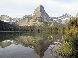
33:Pyramid Peak, as seen from Glenns Lake.
244:lies just northeast of the peak, and
7:
486:Mountains of Glacier County, Montana
417:
415:
299:
297:
155:
122:
335:Geographic Names Information System
439:. You can help Knowledge (XXG) by
14:
419:
154:
147:
121:
114:
27:
16:Mountain in the state of Montana
340:United States Geological Survey
1:
260:, it is located in an alpine
258:Köppen climate classification
171:Show map of the United States
168:Location in the United States
435:state location article is a
522:
414:
271:Glenns Lake, Pyramid Peak
107:
26:
59:760 ft (230 m)
390:Hydrol. Earth Syst. Sci
305:"Pyramid Peak, Montana"
186:Glacier County, Montana
272:
87:48.87333°N 113.83139°W
270:
230:Glacier National Park
501:Mountains of Montana
92:48.87333; -113.83139
138:Show map of Montana
135:Location in Montana
83: /
273:
39:Highest point
448:
447:
262:subarctic climate
219:
218:
513:
469:
462:
455:
423:
416:
406:
405:
385:
379:
378:
376:
374:
361:
355:
354:
352:
350:
326:
320:
319:
317:
315:
301:
248:is to the west.
196:
172:
158:
157:
151:
139:
125:
124:
118:
98:
97:
95:
94:
93:
88:
84:
81:
80:
79:
76:
31:
19:
521:
520:
516:
515:
514:
512:
511:
510:
476:
475:
474:
473:
412:
410:
409:
387:
386:
382:
372:
370:
363:
362:
358:
348:
346:
328:
327:
323:
313:
311:
303:
302:
295:
290:
278:
254:
194:
188:, United States
177:
176:
175:
174:
173:
170:
169:
166:
165:
164:
163:
159:
142:
141:
140:
137:
136:
133:
132:
131:
130:
126:
91:
89:
85:
82:
77:
74:
72:
70:
69:
34:
17:
12:
11:
5:
519:
517:
509:
508:
503:
498:
493:
488:
478:
477:
472:
471:
464:
457:
449:
446:
445:
429:Glacier County
424:
408:
407:
380:
366:Ahern Pass, MT
356:
330:"Pyramid Peak"
321:
309:Peakbagger.com
292:
291:
289:
286:
285:
284:
277:
274:
253:
250:
242:Mokowanis Lake
217:
216:
215:Ahern Pass, MT
210:
204:
203:
198:
190:
189:
183:
179:
178:
167:
161:
160:
153:
152:
146:
145:
144:
143:
134:
128:
127:
120:
119:
113:
112:
111:
110:
109:
108:
105:
104:
100:
99:
67:
61:
60:
57:
51:
50:
47:
41:
40:
36:
35:
32:
24:
23:
15:
13:
10:
9:
6:
4:
3:
2:
518:
507:
504:
502:
499:
497:
494:
492:
489:
487:
484:
483:
481:
470:
465:
463:
458:
456:
451:
450:
444:
442:
438:
434:
430:
425:
422:
418:
413:
403:
399:
396:: 1633–1644.
395:
391:
384:
381:
368:
367:
360:
357:
345:
341:
337:
336:
331:
325:
322:
310:
306:
300:
298:
294:
287:
283:
280:
279:
275:
269:
265:
263:
259:
256:Based on the
251:
249:
247:
243:
239:
235:
231:
227:
223:
214:
211:
209:
205:
202:
199:
197:
191:
187:
184:
180:
150:
117:
106:
101:
96:
68:
66:
62:
58:
56:
52:
48:
46:
42:
37:
30:
25:
20:
441:expanding it
426:
411:
393:
389:
383:
373:December 27,
371:. Retrieved
365:
359:
349:December 27,
347:. Retrieved
333:
324:
314:December 27,
312:. Retrieved
308:
255:
222:Pyramid Peak
221:
220:
195:Parent range
162:Pyramid Peak
129:Pyramid Peak
22:Pyramid Peak
496:Lewis Range
246:Atsina Lake
226:Lewis Range
201:Lewis Range
90: /
78:113°49′53″W
65:Coordinates
480:Categories
288:References
234:U.S. state
75:48°52′24″N
55:Prominence
402:1027-5606
103:Geography
45:Elevation
276:See also
208:Topo map
182:Location
433:Montana
252:Climate
238:Montana
232:in the
400:
427:This
437:stub
398:ISSN
375:2018
351:2018
316:2018
213:USGS
236:of
482::
431:,
394:11
392:.
342:,
338:.
332:.
307:.
296:^
240:.
228:,
468:e
461:t
454:v
443:.
404:.
377:.
353:.
318:.
Text is available under the Creative Commons Attribution-ShareAlike License. Additional terms may apply.


