143:
30:
37:
422:
175:
on the island from 1906 until 1927, used extensively to create concrete structures in the growing city of
Auckland. As a wharf, they sank the first iron ship built in Auckland, the 1876 Rotomahana.
146:
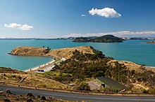
Looking towards Pakihi Island (in the centre of the photo) from
Waitawa Regional Park. (Ponui Island is in the background, and part of Karamuramu Island is visible to the far right.)
417:
131:, New Zealand. With an area of 114 hectares (280 acres), it is one of the smallest of the Hauraki Gulf Islands. It is located 1 km southwest of
412:
407:
142:
29:
402:
276:
71:
331:"Auckland Council District Plan - Hauraki Gulf Islands Section - Operative 2013: The history of human settlement of the islands"
330:
247:
220:"Updated Vascular Flora of Pakihi Island, with notes on fauna, geology and some history, Hauraki Gulf, Auckland"
337:
136:
155:
The island's land use is primarily pastoral and plantations, but with some areas of native vegetation.
164:
387:
359:
219:
168:
171:). William Fraser McCallum and his brothers created a partnership in 1904 and quarried red
396:
132:
124:
110:
50:
277:"Clevedon Sustainable Development Plan Project European Historical Assessment"
305:
86:
73:
192:
167:
by the McCallum family in 1894 (along with the neighbouring, much smaller
128:
172:
141:
248:"Hauraki Gulf Islands District Plan Review Landscape Report"
423:
Populated places around the
Hauraki Gulf / Tīkapa Moana
388:
1930 photo of SS Rotomahana (1876) sunk on shingle spit
102:
65:
60:
227:New Zealand Regional Botanical Societies Journals
8:
18:
360:"PIONEER, VESSEL'S END. NEW ZEALAND HERALD"
286:. Clevedon and Districts Historical Society
123:is a privately-owned island located in the
17:
418:Populated places in the Auckland Region
184:
36:
7:
14:
135:, and 1.5 km offshore from
35:
28:
306:"McCallum Bros Limited History"
413:Private islands of New Zealand
408:Islands of the Auckland Region
199:. Land Information New Zealand
163:The island was purchased from
1:
403:Islands of the Hauraki Gulf
127:to the east of the city of
439:
364:paperspast.natlib.govt.nz
107:
23:
165:Sir John Logan Campbell
147:
338:Auckland City Council
197:New Zealand Gazetteer
145:
137:Waitawa Regional Park
83: /
20:
310:McCallum Bros. Ltd
148:
87:36.908°S 175.164°E
169:Karamuramu Island
118:
117:
430:
375:
374:
372:
371:
356:
350:
349:
347:
345:
335:
327:
321:
320:
318:
316:
302:
296:
295:
293:
291:
284:Auckland Council
281:
272:
266:
265:
263:
261:
255:Auckland Council
252:
244:
238:
237:
235:
233:
224:
215:
209:
208:
206:
204:
189:
98:
97:
95:
94:
93:
92:-36.908; 175.164
88:
84:
81:
80:
79:
76:
39:
38:
32:
21:
438:
437:
433:
432:
431:
429:
428:
427:
393:
392:
384:
379:
378:
369:
367:
358:
357:
353:
343:
341:
333:
329:
328:
324:
314:
312:
304:
303:
299:
289:
287:
279:
275:Munro, Jessie.
274:
273:
269:
259:
257:
250:
246:
245:
241:
231:
229:
222:
218:Cameron, Ewen.
217:
216:
212:
202:
200:
193:"Pakihi Island"
191:
190:
186:
181:
161:
153:
114:
91:
89:
85:
82:
77:
74:
72:
70:
69:
56:
55:
54:
53:
47:
46:
45:
44:
40:
12:
11:
5:
436:
434:
426:
425:
420:
415:
410:
405:
395:
394:
391:
390:
383:
382:External links
380:
377:
376:
351:
322:
297:
267:
239:
210:
183:
182:
180:
177:
160:
157:
152:
149:
116:
115:
108:
105:
104:
103:Administration
100:
99:
67:
63:
62:
58:
57:
48:
42:
41:
34:
33:
27:
26:
25:
24:
13:
10:
9:
6:
4:
3:
2:
435:
424:
421:
419:
416:
414:
411:
409:
406:
404:
401:
400:
398:
389:
386:
385:
381:
366:. 17 Jun 1924
365:
361:
355:
352:
339:
332:
326:
323:
311:
307:
301:
298:
285:
278:
271:
268:
256:
249:
243:
240:
228:
221:
214:
211:
198:
194:
188:
185:
178:
176:
174:
170:
166:
158:
156:
150:
144:
140:
138:
134:
130:
126:
122:
121:Pakihi Island
113:
112:
106:
101:
96:
68:
64:
59:
52:
43:Pakihi Island
31:
22:
19:Pakihi Island
16:
368:. Retrieved
363:
354:
342:. Retrieved
325:
313:. Retrieved
309:
300:
288:. Retrieved
283:
270:
258:. Retrieved
254:
242:
230:. Retrieved
226:
213:
201:. Retrieved
196:
187:
162:
154:
133:Ponui Island
125:Hauraki Gulf
120:
119:
109:
49:Location in
15:
151:Description
111:New Zealand
90: /
78:175°09′50″E
66:Coordinates
51:New Zealand
397:Categories
370:2020-08-23
315:8 December
260:8 December
232:8 December
203:8 December
179:References
75:36°54′29″S
290:29 August
61:Geography
344:15 April
129:Auckland
159:History
340:. 2013
334:(PDF)
280:(PDF)
251:(PDF)
223:(PDF)
173:chert
346:2022
317:2018
292:2018
262:2018
234:2018
205:2018
399::
362:.
336:.
308:.
282:.
253:.
225:.
195:.
139:.
373:.
348:.
319:.
294:.
264:.
236:.
207:.
Text is available under the Creative Commons Attribution-ShareAlike License. Additional terms may apply.