43:
370:
598:
432:
278:
The W.A. State
Primary School the corner of what was then McKimmie Street (now McKimmie Road) between Zenobia and Aurelian Streets, was established in 1913. Its first Centenary was celebrated enthusiastically by students, residents and past pupils on Saturday 9 November 2013. There is also a School
282:
Palmyra includes the
Fremantle Cemetery at its south-eastern suburb boundary, south of High Street/Leach Highway. Starting from its northern boundary, clockwise, Palmyra is bounded by the Canning Highway; by Stock Road on its East; by Sainsbury Road on its South; and in a dog-leg, by Carrington
279:
associated with the
Catholic Our Lady of Fatima Church at 8 Foss Street. The St Peter and St Mark Anglican Church is a 2 Hammad Road. The Uniting Church is at the corner of Carrington Street and the Canning Highway. The Seventh Day Adventist Church meets on Saturdays at 10 Cleopatra Street.
275:
The suburb east of
Fremantle appears to have been first established as the Palmyra Estate in 1903. The north-eastern corner of Palmyra is some 14 kilometres (8.7 mi) from the Perth G.P.O.
64:
177:
161:
463:
668:
658:
149:
639:
663:
382:
456:
436:
235:
552:
449:
220:
203:
410:
369:
347:
170:
42:
632:
492:
240:
532:
497:
527:
522:
166:
57:
577:
572:
547:
537:
507:
245:
228:
213:
329:
Lou
Stonham Park bordering Stock Road, between McGregor Road and Forrest Street and the turn off from Leach Highway.
557:
542:
512:
502:
625:
562:
517:
208:
265:
142:
441:
293:
King Victor's Green, between Hammad, Baal and Elvira
Streets, where the Miller Bakehouse Museum is situated
351:
120:
112:
286:
The
Melville History Society meets at the Miller Bakehouse, corner of Elvira and Baal Streets, Palmyra.
194:
182:
481:
317:
Reddings
Reserve, interrupting the course of Baal Street between Cleopatra and Solomon Streets
33:
609:
473:
269:
154:
414:
597:
652:
283:
Street on its West, and
Marmion Street on its South, and Petra Street on its West.
299:
Geo
Thompson Park on McKimmie Road diagonally opposite Palmyra Primary School
80:
66:
326:
Bill Sheehy Park between Justinian Street, McGregor Road and Leach Highway,
431:
397:"pally is 100 | Celebrating Palmyra Primary School's Centenary in 2013"
302:
Woolshed Park, bounded by McGregor Road, from Goy Close to Baal Street
605:
477:
396:
29:
314:
Public open space on the corner of Justinian and Solomon Streets
445:
323:
John O'Sullivan Park on the corner of Marmion and Baal Streets
308:
Dinosaur Park on the corner of Carrington and Aurelian Streets
305:
Dark Park on the corner of Carrington Street and McGregor Road
311:
Three Bears Park on the corner of Adrian and Tamar Streets
613:
320:
Oz Park on the corner of Aurelian and Justinian Streets
176:
160:
148:
137:
129:
119:
104:
56:
23:
189:
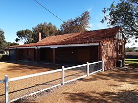
47:The historic Millers' Bakehouse Museum, Palmyra
633:
457:
8:
109:
640:
626:
464:
450:
442:
368:
41:
20:
669:Perth, Western Australia geography stubs
289:There are a number of parks in Palmyra;
339:
296:Emily Main Park, south of Palin Street,
233:
218:
201:
191:
7:
594:
592:
352:"Palmyra (WA) (suburb and locality)"
659:Suburbs of Perth, Western Australia
612:. You can help Knowledge (XXG) by
18:Suburb of Perth, Western Australia
14:
356:Australian Census 2021 QuickStats
133:3.1 km (1.2 sq mi)
596:
430:
383:"21 Aug 1903 - PALMYRA. - Trove"
664:Suburbs in the City of Melville
348:Australian Bureau of Statistics
1:
141:16 km (10 mi) from
685:
591:
437:Palmyra, Western Australia
411:"Melville History Society"
488:
251:
192:
188:
81:32.044968°S 115.7858881°E
52:
40:
266:Perth, Western Australia
86:-32.044968; 115.7858881
608:location article is a
439:at Wikimedia Commons
268:, located within the
178:Federal division(s)
162:State electorate(s)
76: /
621:
620:
586:
585:
482:Western Australia
435:Media related to
417:on 10 April 2013.
259:
258:
255:
254:
34:Western Australia
676:
642:
635:
628:
600:
593:
474:City of Melville
466:
459:
452:
443:
434:
419:
418:
413:. Archived from
407:
401:
400:
393:
387:
386:
379:
373:
372:
366:
364:
362:
350:(28 June 2022).
344:
270:City of Melville
236:White Gum Valley
190:
155:City of Melville
111:
100:
99:
97:
96:
95:
93:
88:
87:
82:
77:
74:
73:
72:
69:
45:
36:
26:
21:
684:
683:
679:
678:
677:
675:
674:
673:
649:
648:
647:
646:
589:
587:
582:
484:
472:Suburbs of the
470:
428:
423:
422:
409:
408:
404:
395:
394:
390:
381:
380:
376:
360:
358:
346:
345:
341:
336:
264:is a suburb of
197:around Palmyra:
91:
89:
85:
83:
79:
78:
75:
70:
67:
65:
63:
62:
48:
28:
27:
24:
19:
12:
11:
5:
682:
680:
672:
671:
666:
661:
651:
650:
645:
644:
637:
630:
622:
619:
618:
601:
584:
583:
581:
580:
575:
570:
565:
560:
555:
553:Mount Pleasant
550:
545:
540:
535:
530:
525:
520:
515:
510:
505:
500:
495:
489:
486:
485:
471:
469:
468:
461:
454:
446:
427:
426:External links
424:
421:
420:
402:
388:
374:
338:
337:
335:
332:
331:
330:
327:
324:
321:
318:
315:
312:
309:
306:
303:
300:
297:
294:
257:
256:
253:
252:
249:
248:
243:
238:
232:
231:
226:
223:
221:East Fremantle
217:
216:
211:
206:
204:East Fremantle
200:
199:
186:
185:
180:
174:
173:
164:
158:
157:
152:
146:
145:
139:
135:
134:
131:
127:
126:
123:
117:
116:
106:
102:
101:
60:
54:
53:
50:
49:
46:
38:
37:
17:
13:
10:
9:
6:
4:
3:
2:
681:
670:
667:
665:
662:
660:
657:
656:
654:
643:
638:
636:
631:
629:
624:
623:
617:
615:
611:
607:
602:
599:
595:
590:
579:
576:
574:
571:
569:
566:
564:
561:
559:
556:
554:
551:
549:
546:
544:
541:
539:
536:
534:
531:
529:
526:
524:
521:
519:
516:
514:
511:
509:
506:
504:
501:
499:
496:
494:
491:
490:
487:
483:
479:
475:
467:
462:
460:
455:
453:
448:
447:
444:
440:
438:
433:
425:
416:
412:
406:
403:
398:
392:
389:
384:
378:
375:
371:
357:
353:
349:
343:
340:
333:
328:
325:
322:
319:
316:
313:
310:
307:
304:
301:
298:
295:
292:
291:
290:
287:
284:
280:
276:
273:
271:
267:
263:
250:
247:
244:
242:
239:
237:
234:
230:
227:
224:
222:
219:
215:
212:
210:
207:
205:
202:
198:
196:
187:
184:
181:
179:
175:
172:
168:
165:
163:
159:
156:
153:
151:
147:
144:
140:
136:
132:
128:
124:
122:
118:
114:
107:
103:
98:
61:
59:
55:
51:
44:
39:
35:
31:
22:
16:
614:expanding it
603:
588:
567:
429:
415:the original
405:
391:
377:
359:. Retrieved
355:
342:
288:
285:
281:
277:
274:
261:
260:
193:
15:
493:Alfred Cove
121:Postcode(s)
84: /
71:115°47′09″E
58:Coordinates
653:Categories
533:Bull Creek
498:Applecross
334:References
105:Population
90: (
68:32°02′42″S
528:Brentwood
523:Booragoon
183:Fremantle
171:Fremantle
578:Winthrop
573:Willagee
548:Melville
538:Kardinya
508:Attadale
246:Willagee
241:O'Connor
229:Melville
214:Attadale
138:Location
568:Palmyra
558:Murdoch
543:Leeming
513:Bateman
503:Ardross
361:28 June
262:Palmyra
225:Palmyra
195:Suburbs
108:7,585 (
92:Palmyra
32:,
25:Palmyra
563:Myaree
518:Bicton
367:
209:Bicton
167:Bicton
150:LGA(s)
606:Perth
604:This
478:Perth
143:Perth
30:Perth
610:stub
363:2022
130:Area
125:6157
113:2021
110:SAL
655::
480:,
476:,
354:.
272:.
169:/
641:e
634:t
627:v
616:.
465:e
458:t
451:v
399:.
385:.
365:.
115:)
94:)
Text is available under the Creative Commons Attribution-ShareAlike License. Additional terms may apply.