705:
56:
212:
646:. A sound, 12 nautical miles (22 km; 14 mi) long and 6 nautical miles (11 km; 6.9 mi) wide, extending in a northwest–southeast direction between the northeast side of Dundee Island and the east portion of Joinville Island. It merges to the northwest with Active Sound with which it completes the separation of Dundee and Joinville Islands. Discovered in 1892–93 by Captain Thomas Robertson of the Dundee whaling expedition and named by him after the
204:
688:. A sound, averaging 2 nautical miles (3.7 km; 2.3 mi) wide, extending in an east-northeast direction from Antarctic Sound and joining the Firth of Tay with which it separates Joinville and Dundee Islands. Discovered in 1892-93 by Captain Thomas Robertson of the Dundee whaling expedition. Robertson named the feature after his ship, the Active, first vessel to navigate the sound.
63:
355:. Northernmost island of the Joinville Island group, 17 nautical miles (31 km; 20 mi) long, lying immediately north of Joinville Island, from which it is separated by Larsen Channel. Charted in 1902 by the SwedAE under Otto Nordenskjöld, who named it for Captain Jules Dumont d'Urville, French explorer who discovered land in the Joinville Island group.
399:. Largest island of the Joinville Island group, about 40 nautical miles (74 km; 46 mi) long in an east–west direction and 12 nautical miles (22 km; 14 mi) wide, lying off the northeast tip of Antarctic Peninsula, from which it is separated by Antarctic Sound. Discovered and roughly charted in 1838 by a French expedition under Captain
1598:
1540:
1204:. A circular island 1 nautical mile (1.9 km; 1.2 mi) in diameter with precipitous cliffs of volcanic rock rising to a snow-covered peak 435 metres (1,427 ft) high high, lying west of Dundee Island in the south entrance to Antarctic Sound. Discovered by the French expedition, 1837-40, under Captain
1062:. A rock lying east of Eden Rocks, off the east end of Dundee Island. The name Cape Puget was given by Sir James Clark Ross on December 30, 1842, for Captain William D. Puget, Royal Navy, but it is not clear from Ross' text what feature he was naming. The name Puget Rock was given by the
40:
742:. An island nearly 5 nautical miles (9.3 km; 5.8 mi) |long, lying 3 nautical miles (5.6 km; 3.5 mi) southwest of D'Urville Island. The name Point Bransfield, after Edward Bransfield, Master, Royal Navy, was given in 1842 by a British expedition under
976:. An isolated island lying 5 nautical miles (9.3 km; 5.8 mi) northwest of Darwin Island, off the southeast end of Joinville Island. Surveyed by the FIDS in 1953. So named by the UK-APC because the island lies in an area where brash ice is frequently found.
1162:. A circular island about 1 nautical mile (1.9 km; 1.2 mi) in diameter, lying 3 nautical miles (5.6 km; 3.5 mi) southeast of Dundee Island. Discovered by a British expedition under Ross, 1839-43, and named by him for Captain the Right Honorable
512:. Body of water about 30 nautical miles (56 km; 35 mi) long and from 7 to 12 nautical miles (13 to 22 km; 8.1 to 13.8 mi) wide, separating the Joinville Island group from the northeast end of the Antarctic Peninsula. The sound was named by the
604:. A strait 1 to 3 nautical miles (1.9 to 5.6 km; 1.2 to 3.5 mi) wide between D'Urville Island and Joinville Island. Discovered in 1902 by the Swedish Antarctic Expedition under Nordenskjold, and named for Captain C.A. Larsen of the expedition ship
1110:. Two rocks lying just off the east end of Dundee Island. A small island was reported here by Captain James Clark Ross, Royal Navy, on December 30,1842. He named it "Eden Island" for Captain Charles Eden, Royal Navy. Following survey by the
1602:
1544:
836:. A group of islands and rocks lying 7 nautical miles (13 km; 8.1 mi) north of Boreal Point, Joinville Island. Roughly surveyed from a distance by the FIDS in 1953-54. So named by the
455:. Ice-covered island lying east of the northeast tip of Antarctic Peninsula and south of Joinville Island. Discovered on January 8, 1893 by Captain Thomas Robertson of the
924:. An island with a high summit, lying 6 nautical miles (11 km; 6.9 mi) north of the eastern end of Joinville Island. Discovered by a British expedition under
404:
1020:. Group of islands lying 13 nautical miles (24 km; 15 mi) east-southeast of Joinville Island. Discovered December 28, 1842 by a British expedition under
746:
to the low western termination of what is now the
Joinville Island group. A 1947 survey by the FIDS determined that this western termination is a separate island.
101:
562:. A marine passage between D'Urville Island and Bransfield Island. Charted in 1947 by the FIDS and named after Eugene Burden (1892-1979), who, as master of the
1548:
1024:, who so named them because, appearing among heavy fragments of ice, they were almost completely concealed until the ship was nearly upon them.
55:
1111:
883:
788:, off the north coast of Joinville Island. The name was applied by the Argentine Antarctic Expedition (1953-54) because large numbers of
878:. A small but prominent island, more than 75 metres (246 ft) high, lying 2 nautical miles (3.7 km; 2.3 mi) northwest of
1063:
837:
1626:
1621:
1606:
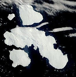
320:
216:
1114:(FIDS) in 1953, it was reported that the feature consists of two rocks lying close together. The Eden Rocks are a designated
1176:
1134:
1082:
1034:
992:
948:
896:
850:
808:
756:
714:
660:
618:
576:
534:
484:
427:
371:
327:
513:
276:
1205:
400:
303:
879:
247:
is at the center of the group. Other islands and rocks include, clockwise from the west, Bransfield Island,
156:
298:
886:(FIDS) in 1953. The name is descriptive of the island's shape; Patella is the Latin name for a limpet.
293:
1555:
840:(UK-APC) in 1958 because of their exposed, isolated position on the south side of Bransfield Strait.
517:
1578:
1115:
704:
248:
240:
211:
188:
1163:
463:, Scotland, from whence the ship sailed in company with three other vessels in search of whales.
1209:
524:
which in 1902, under the command of
Captain C.A. Larsen, was the first vessel to navigate it.
236:
39:
1021:
925:
801:
743:
408:
364:
244:
220:
477:
192:
1231:
Sailing
Directions for Antarctica: Including the Off-lyng Islands South of Latitude 60̊
985:
789:
288:
1615:
1127:
784:. A small circular island lying 4 nautical miles (7.4 km; 4.6 mi) west of
420:
260:
256:
224:
1521:
941:
785:
647:
1245:
1229:
232:
203:
1075:
929:
252:
89:
1191:
1178:
1149:
1136:
1097:
1084:
1049:
1036:
1007:
994:
963:
950:
911:
898:
865:
852:
823:
810:
771:
758:
729:
716:
675:
662:
633:
620:
591:
578:
549:
536:
499:
486:
442:
429:
386:
373:
342:
329:
207:
Trinity
Peninsula on Antarctic Peninsula. Joinville Island group to the north
117:
103:
181:
17:
184:
1212:, French Minister of Marine under whose orders the expedition sailed.
460:
1066:(UK-APC) in 1956 in order to preserve Ross' name in this vicinity.
928:, 1839-43, who so named it because of its resemblance to volcanic
703:
210:
202:
1272:
1247:
Sailing
Directions (planning Guide & Enroute).: Antarctica
243:. It is separated from the mainland by the Antarctic Sound.
1563:
882:
off the north coast of
Joinville Island. Surveyed by the
1379:
1377:
191:, from which Joinville Island group is separated by the
1529:(2 ed.), United States Board on Geographic Names
696:Smaller islands, clockwise from the west, include:
167:
162:
149:
141:
95:
85:
80:
251:, Wideopen Islands, Brash Island, Danger Islands,
792:(Pygoscelis papua) were sighted on this island.
566:, first navigated the passage in January 1947.
1562:, BirdLife International, 2012, archived from
1479:
62:
8:
32:
1228:Office, United States Hydrographic (1943).
38:
31:
1560:BirdLife data zone: Important Bird Areas
187:, lying off the northeastern tip of the
1549:United States Board on Geographic Names
1503:
1491:
1467:
1455:
1443:
1431:
1419:
1407:
1395:
1383:
1368:
1356:
1344:
1332:
1320:
1308:
1296:
1284:
1260:
1220:
405:François d'Orléans, Prince of Joinville
1580:Graham Land and South Shetland Islands
1583:, BAS: British Antarctic Survey, 2005
7:
1112:Falkland Islands Dependencies Survey
884:Falkland Islands Dependencies Survey
708:Bransfield Island, October 27, 2016
231:The Joinville Island group lies in
1605:from websites or documents of the
1547:from websites or documents of the
1273:Graham Land and South Shetland BAS
1208:, and named by him for V. Admiral
1064:UK Antarctic Place-Names Committee
838:UK Antarctic Place-Names Committee
407:(1818-1900), the third son of the
25:
1523:Geographic Names of the Antarctic
1234:. Hydrographic Office, U.S. Navy.
239:, which is itself the tip of the
1601: This article incorporates
1596:
1543: This article incorporates
1538:
61:
54:
1607:United States Geological Survey
1520:Alberts, Fred G., ed. (1995),
44:Satellite picture of the group
1:
459:and named for the home port,
514:Swedish Antarctic Expedition
321:D'Urville Island, Antarctica
314:
227:(5) – Bransfield Island (14)
304:GPX (secondary coordinates)
1643:
1125:
1073:
983:
939:
799:
475:
418:
362:
318:
235:to the east of the tip of
27:Group of Antarctic islands
299:GPX (primary coordinates)
274:Map all coordinates using
154:
49:
37:
520:for the expedition ship
282:Download coordinates as:
215:Joinville Island group:
157:Antarctic Treaty System
155:Administered under the
1627:Islands of Graham Land
1622:Joinville Island group
1603:public domain material
1545:public domain material
1206:Jules Dumont d'Urville
709:
401:Jules Dumont d'Urville
228:
208:
178:Joinville Island group
145:Joinville Island group
129:Joinville Island group
69:Joinville Island group
33:Joinville Island group
707:
294:GPX (all coordinates)
214:
206:
1470:, pp. 210–211.
1250:. The Agency. 2002.
1188: /
1146: /
1116:Important Bird Area
1094: /
1046: /
1004: /
960: /
908: /
862: /
820: /
768: /
726: /
672: /
630: /
588: /
546: /
496: /
439: /
403:, who named it for
383: /
339: /
241:Antarctic Peninsula
189:Antarctic Peninsula
113: /
34:
1480:Eden Rocks Birdlfe
1164:Lord George Paulet
710:
229:
209:
1210:Claude de Rosamel
1192:63.567°S 56.283°W
1150:63.583°S 55.783°W
1098:63.483°S 55.667°W
1050:63.483°S 55.650°W
1008:63.417°S 54.667°W
964:63.400°S 54.917°W
912:63.083°S 55.150°W
866:63.133°S 55.483°W
824:63.000°S 55.817°W
772:63.117°S 55.950°W
730:63.183°S 56.600°W
700:Bransfield Island
676:63.417°S 56.167°W
634:63.367°S 55.750°W
592:63.167°S 56.200°W
550:63.133°S 56.533°W
518:Otto Nordenskjöld
500:63.333°S 56.750°W
443:63.500°S 55.917°W
387:63.250°S 55.750°W
343:63.083°S 56.333°W
237:Trinity Peninsula
175:
174:
118:63.250°S 55.750°W
16:(Redirected from
1634:
1600:
1599:
1591:
1590:
1588:
1574:
1573:
1571:
1542:
1541:
1537:
1536:
1534:
1528:
1507:
1501:
1495:
1489:
1483:
1477:
1471:
1465:
1459:
1453:
1447:
1441:
1435:
1429:
1423:
1417:
1411:
1405:
1399:
1393:
1387:
1381:
1372:
1366:
1360:
1354:
1348:
1342:
1336:
1330:
1324:
1318:
1312:
1306:
1300:
1294:
1288:
1282:
1276:
1270:
1264:
1258:
1252:
1251:
1242:
1236:
1235:
1225:
1203:
1202:
1200:
1199:
1198:
1197:-63.567; -56.283
1193:
1189:
1186:
1185:
1184:
1181:
1161:
1160:
1158:
1157:
1156:
1155:-63.583; -55.783
1151:
1147:
1144:
1143:
1142:
1139:
1109:
1108:
1106:
1105:
1104:
1103:-63.483; -55.667
1099:
1095:
1092:
1091:
1090:
1087:
1061:
1060:
1058:
1057:
1056:
1055:-63.483; -55.650
1051:
1047:
1044:
1043:
1042:
1039:
1022:James Clark Ross
1019:
1018:
1016:
1015:
1014:
1013:-63.417; -54.667
1009:
1005:
1002:
1001:
1000:
997:
975:
974:
972:
971:
970:
969:-63.400; -54.917
965:
961:
958:
957:
956:
953:
926:James Clark Ross
923:
922:
920:
919:
918:
917:-63.083; -55.150
913:
909:
906:
905:
904:
901:
877:
876:
874:
873:
872:
871:-63.133; -55.483
867:
863:
860:
859:
858:
855:
835:
834:
832:
831:
830:
829:-63.000; -55.817
825:
821:
818:
817:
816:
813:
802:Wideopen Islands
796:Wideopen Islands
783:
782:
780:
779:
778:
777:-63.117; -55.950
773:
769:
766:
765:
764:
761:
744:James Clark Ross
741:
740:
738:
737:
736:
735:-63.183; -56.600
731:
727:
724:
723:
722:
719:
687:
686:
684:
683:
682:
681:-63.417; -56.167
677:
673:
670:
669:
668:
665:
645:
644:
642:
641:
640:
639:-63.367; -55.750
635:
631:
628:
627:
626:
623:
603:
602:
600:
599:
598:
597:-63.167; -56.200
593:
589:
586:
585:
584:
581:
561:
560:
558:
557:
556:
555:-63.133; -56.533
551:
547:
544:
543:
542:
539:
511:
510:
508:
507:
506:
505:-63.333; -56.750
501:
497:
494:
493:
492:
489:
454:
453:
451:
450:
449:
448:-63.500; -55.917
444:
440:
437:
436:
435:
432:
398:
397:
395:
394:
393:
392:-63.250; -55.750
388:
384:
381:
380:
379:
376:
365:Joinville Island
359:Joinville Island
354:
353:
351:
350:
349:
348:-63.083; -56.333
344:
340:
337:
336:
335:
332:
315:D'Urville Island
249:D'Urville Island
245:Joinville Island
221:Joinville Island
217:D'Urville Island
137:
136:
134:
133:
132:
130:
125:
124:
123:-63.250; -55.750
119:
114:
111:
110:
109:
106:
65:
64:
58:
42:
35:
21:
1642:
1641:
1637:
1636:
1635:
1633:
1632:
1631:
1612:
1611:
1597:
1594:
1586:
1584:
1577:
1569:
1567:
1566:on 10 July 2007
1554:
1539:
1532:
1530:
1526:
1519:
1515:
1510:
1502:
1498:
1490:
1486:
1478:
1474:
1466:
1462:
1454:
1450:
1442:
1438:
1430:
1426:
1418:
1414:
1406:
1402:
1394:
1390:
1382:
1375:
1367:
1363:
1355:
1351:
1343:
1339:
1331:
1327:
1319:
1315:
1307:
1303:
1295:
1291:
1283:
1279:
1271:
1267:
1259:
1255:
1244:
1243:
1239:
1227:
1226:
1222:
1218:
1196:
1194:
1190:
1187:
1182:
1179:
1177:
1175:
1174:
1172:
1154:
1152:
1148:
1145:
1140:
1137:
1135:
1133:
1132:
1130:
1124:
1102:
1100:
1096:
1093:
1088:
1085:
1083:
1081:
1080:
1078:
1072:
1054:
1052:
1048:
1045:
1040:
1037:
1035:
1033:
1032:
1030:
1012:
1010:
1006:
1003:
998:
995:
993:
991:
990:
988:
982:
968:
966:
962:
959:
954:
951:
949:
947:
946:
944:
938:
916:
914:
910:
907:
902:
899:
897:
895:
894:
892:
870:
868:
864:
861:
856:
853:
851:
849:
848:
846:
828:
826:
822:
819:
814:
811:
809:
807:
806:
804:
798:
790:gentoo penguins
776:
774:
770:
767:
762:
759:
757:
755:
754:
752:
734:
732:
728:
725:
720:
717:
715:
713:
712:
702:
694:
692:Smaller islands
680:
678:
674:
671:
666:
663:
661:
659:
658:
656:
638:
636:
632:
629:
624:
621:
619:
617:
616:
614:
596:
594:
590:
587:
582:
579:
577:
575:
574:
572:
554:
552:
548:
545:
540:
537:
535:
533:
532:
530:
516:(SwedAE) under
504:
502:
498:
495:
490:
487:
485:
483:
482:
480:
478:Antarctic Sound
474:
472:Antarctic Sound
469:
447:
445:
441:
438:
433:
430:
428:
426:
425:
423:
417:
391:
389:
385:
382:
377:
374:
372:
370:
369:
367:
361:
347:
345:
341:
338:
333:
330:
328:
326:
325:
323:
317:
312:
311:
310:
309:
308:
269:
201:
193:Antarctic Sound
128:
126:
122:
120:
116:
115:
112:
107:
104:
102:
100:
99:
76:
75:
74:
73:
72:
71:
70:
66:
45:
28:
23:
22:
15:
12:
11:
5:
1640:
1638:
1630:
1629:
1624:
1614:
1613:
1593:
1592:
1575:
1552:
1516:
1514:
1511:
1509:
1508:
1506:, p. 630.
1496:
1494:, p. 561.
1484:
1472:
1460:
1458:, p. 594.
1448:
1446:, p. 171.
1436:
1434:, p. 227.
1424:
1422:, p. 559.
1412:
1410:, p. 811.
1400:
1398:, p. 555.
1388:
1373:
1361:
1359:, p. 734.
1349:
1347:, p. 419.
1337:
1335:, p. 104.
1325:
1313:
1311:, p. 204.
1301:
1299:, p. 375.
1289:
1287:, p. 205.
1277:
1265:
1253:
1237:
1219:
1217:
1214:
1171:
1170:Rosamel Island
1168:
1126:Main article:
1123:
1120:
1074:Main article:
1071:
1068:
1029:
1026:
986:Danger Islands
984:Main article:
981:
980:Danger Islands
978:
940:Main article:
937:
934:
891:
888:
845:
844:Patella Island
842:
800:Main article:
797:
794:
751:
748:
701:
698:
693:
690:
655:
652:
613:
610:
571:
570:Larsen Channel
568:
529:
528:Burden Passage
526:
476:Main article:
473:
470:
468:
465:
419:Main article:
416:
413:
363:Main article:
360:
357:
319:Main article:
316:
313:
307:
306:
301:
296:
291:
285:
279:
272:
271:
270:
268:
265:
200:
197:
180:is a group of
173:
172:
169:
165:
164:
160:
159:
152:
151:
150:Administration
147:
146:
143:
139:
138:
97:
93:
92:
87:
83:
82:
78:
77:
68:
67:
60:
59:
53:
52:
51:
50:
47:
46:
43:
26:
24:
14:
13:
10:
9:
6:
4:
3:
2:
1639:
1628:
1625:
1623:
1620:
1619:
1617:
1610:
1608:
1604:
1582:
1581:
1576:
1565:
1561:
1557:
1553:
1550:
1546:
1525:
1524:
1518:
1517:
1512:
1505:
1500:
1497:
1493:
1488:
1485:
1481:
1476:
1473:
1469:
1464:
1461:
1457:
1452:
1449:
1445:
1440:
1437:
1433:
1428:
1425:
1421:
1416:
1413:
1409:
1404:
1401:
1397:
1392:
1389:
1386:, p. 89.
1385:
1380:
1378:
1374:
1370:
1365:
1362:
1358:
1353:
1350:
1346:
1341:
1338:
1334:
1329:
1326:
1323:, p. 23.
1322:
1317:
1314:
1310:
1305:
1302:
1298:
1293:
1290:
1286:
1281:
1278:
1274:
1269:
1266:
1262:
1257:
1254:
1249:
1248:
1241:
1238:
1233:
1232:
1224:
1221:
1215:
1213:
1211:
1207:
1201:
1169:
1167:
1165:
1159:
1129:
1128:Paulet Island
1122:Paulet Island
1121:
1119:
1117:
1113:
1107:
1077:
1069:
1067:
1065:
1059:
1027:
1025:
1023:
1017:
987:
979:
977:
973:
943:
935:
933:
931:
927:
921:
889:
887:
885:
881:
875:
843:
841:
839:
833:
803:
795:
793:
791:
787:
781:
749:
747:
745:
739:
706:
699:
697:
691:
689:
685:
653:
651:
650:of Scotland.
649:
643:
611:
609:
607:
601:
569:
567:
565:
559:
527:
525:
523:
519:
515:
509:
479:
471:
466:
464:
462:
458:
452:
422:
421:Dundee Island
415:Dundee Island
414:
412:
410:
409:Due d'Orleans
406:
402:
396:
366:
358:
356:
352:
322:
305:
302:
300:
297:
295:
292:
290:
287:
286:
284:
283:
278:
277:OpenStreetMap
275:
266:
264:
262:
261:Dundee Island
258:
257:Paulet Island
254:
250:
246:
242:
238:
234:
226:
225:Dundee Island
222:
218:
213:
205:
198:
196:
194:
190:
186:
183:
179:
170:
166:
161:
158:
153:
148:
144:
140:
135:
98:
94:
91:
88:
84:
79:
57:
48:
41:
36:
30:
19:
1595:
1585:, retrieved
1579:
1568:, retrieved
1564:the original
1559:
1556:"Eden Rocks"
1531:, retrieved
1522:
1504:Alberts 1995
1499:
1492:Alberts 1995
1487:
1475:
1468:Alberts 1995
1463:
1456:Alberts 1995
1451:
1444:Alberts 1995
1439:
1432:Alberts 1995
1427:
1420:Alberts 1995
1415:
1408:Alberts 1995
1403:
1396:Alberts 1995
1391:
1384:Alberts 1995
1371:, p. 3.
1369:Alberts 1995
1364:
1357:Alberts 1995
1352:
1345:Alberts 1995
1340:
1333:Alberts 1995
1328:
1321:Alberts 1995
1316:
1309:Alberts 1995
1304:
1297:Alberts 1995
1292:
1285:Alberts 1995
1280:
1268:
1261:Alberts 1995
1256:
1246:
1240:
1230:
1223:
1173:
1131:
1079:
1031:
989:
945:
942:Brash Island
936:Brash Island
893:
847:
805:
786:Boreal Point
753:
750:Papua Island
711:
695:
657:
654:Active Sound
648:Firth of Tay
615:
612:Firth of Tay
605:
573:
563:
531:
521:
481:
456:
424:
368:
324:
281:
280:
273:
267:Main islands
230:
177:
176:
163:Demographics
29:
18:Papua Island
1570:19 December
1195: /
1153: /
1101: /
1053: /
1011: /
967: /
915: /
890:Etna Island
869: /
827: /
775: /
733: /
679: /
637: /
595: /
553: /
503: /
446: /
390: /
346: /
233:Graham Land
171:Uninhabited
142:Archipelago
121: /
96:Coordinates
1616:Categories
1533:3 December
1216:References
1076:Eden Rocks
1070:Eden Rocks
1028:Puget Rock
930:Mount Etna
880:Ambush Bay
253:Eden Rocks
168:Population
127: (
90:Antarctica
606:Antarctic
564:Trepassey
522:Antarctic
182:antarctic
81:Geography
199:Location
86:Location
1513:Sources
1183:56°17′W
1180:63°34′S
1141:55°47′W
1138:63°35′S
1089:55°40′W
1086:63°29′S
1041:55°39′W
1038:63°29′S
999:54°40′W
996:63°25′S
955:54°55′W
952:63°24′S
903:55°09′W
900:63°05′S
857:55°29′W
854:63°08′S
815:55°49′W
812:63°00′S
763:55°57′W
760:63°07′S
721:56°36′W
718:63°11′S
667:56°10′W
664:63°25′S
625:55°45′W
622:63°22′S
583:56°12′W
580:63°10′S
541:56°32′W
538:63°08′S
491:56°45′W
488:63°20′S
467:Straits
434:55°55′W
431:63°30′S
378:55°45′W
375:63°15′S
334:56°20′W
331:63°05′S
185:islands
108:55°45′W
105:63°15′S
461:Dundee
457:Active
223:(4) –
219:(3) –
1587:3 May
1527:(PDF)
1589:2024
1572:2012
1535:2023
289:KML
1618::
1609:.
1558:,
1376:^
1166:.
1118:.
932:.
608:.
411:.
263:.
259:,
255:,
195:.
1551:.
1482:.
1275:.
1263:.
131:)
20:)
Text is available under the Creative Commons Attribution-ShareAlike License. Additional terms may apply.