144:
30:
64:
22:
446:
507:
568:
491:
133:
563:
396:
544:
111:
410:
484:
126:
84:
537:
254:
477:
183:
119:
76:
95:
29:
63:
573:
259:
208:
106:
53:
530:
383:
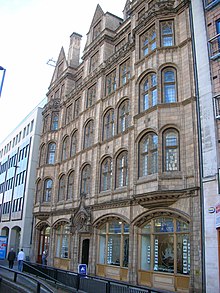
173:
57:
455:
249:
198:
45:
21:
244:
98:
was built opposite the western end of
Paradise Street. For a few years in the 1960s Birmingham Borough
445:
72:
239:
99:
87:
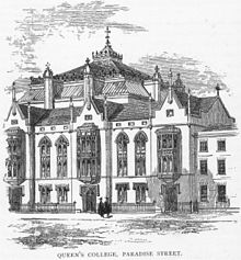
had its first building on
Paradise Street (opened 1860) but moved to Margaret Street when the
514:
461:
234:
41:
357:
60:. The street existed in 1796 when a congregation gathered at a meeting hall for a sermon.
275:
203:
557:
229:
188:
168:
193:
367:
362:
178:
506:
341:
321:
311:
301:
149:
143:
88:
80:
425:
412:
336:
331:
326:
316:
306:
296:
291:
49:
25:
The grade II listed 1904 façade of Queen's
College on Paradise Street
62:
28:
20:
115:
513:
This
England road or road transport-related article is a
518:
465:
79:(started 1843) which was the first establishment in
376:
350:
284:
268:
222:
161:
67:The original Queen's College in Paradise Street
538:
485:
127:
8:
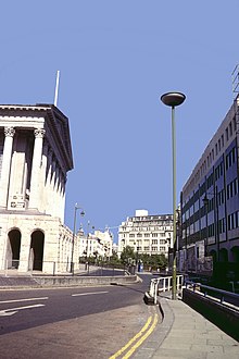
71:Paradise Street is noted as the location of
545:
531:
492:
478:
134:
120:
112:
75:(started in 1832) and the former site of
102:had its office at 25A Paradise Street.
569:West Midlands (county) geography stubs
7:
564:Streets in Birmingham, West Midlands
503:
501:
442:
440:
52:. Paradise Street runs roughly from
517:. You can help Knowledge (XXG) by
464:. You can help Knowledge (XXG) by
14:
505:
444:
142:
94:The head office building of the
85:Birmingham and Midland Institute
33:A front view of Paradise Street
1:
16:Street in Birmingham, England
105:The street gave its name to
96:Birmingham Canal Navigations
91:was developed in the 1960s.
77:Queen's College, Birmingham
590:
500:
439:
392:
40:is a short street in the
322:A4540 (middle ring road)
312:A4400 (inner ring road)
302:A4040 (outer ring road)
109:, which lies adjacent.
89:Inner Ring Road (A4400)
460:location article is a
83:to grant degrees. The
68:
56:to Suffolk Street and
46:Birmingham City Centre
34:
26:
147:Streets and roads in
66:
32:
24:
73:Birmingham Town Hall
422: /
223:City centre squares
162:City centre streets
574:England road stubs
426:52.4791°N 1.9040°W
240:Chamberlain Square
184:Corporation Street
69:
35:
27:
526:
525:
473:
472:
405:
404:
581:
547:
540:
533:
509:
502:
494:
487:
480:
459:
458:
448:
441:
437:
436:
434:
433:
432:
431:52.4791; -1.9040
427:
423:
420:
419:
418:
415:
269:Suburban streets
235:Centenary Square
156:
152:
146:
136:
129:
122:
113:
589:
588:
584:
583:
582:
580:
579:
578:
554:
553:
552:
551:
499:
498:
454:
453:
430:
428:
424:
421:
416:
413:
411:
409:
408:
406:
401:
388:
372:
346:
280:
264:
260:Victoria Square
255:St Pauls Square
218:
214:Paradise Street
209:Paradise Circus
157:
154:
148:
140:
107:Paradise Circus
54:Victoria Square
38:Paradise Street
17:
12:
11:
5:
587:
585:
577:
576:
571:
566:
556:
555:
550:
549:
542:
535:
527:
524:
523:
510:
497:
496:
489:
482:
474:
471:
470:
449:
403:
402:
400:
399:
393:
390:
389:
387:
386:
380:
378:
374:
373:
371:
370:
365:
360:
354:
352:
348:
347:
345:
344:
339:
334:
329:
324:
319:
314:
309:
304:
299:
294:
288:
286:
282:
281:
279:
278:
276:Orphanage Road
272:
270:
266:
265:
263:
262:
257:
252:
247:
242:
237:
232:
226:
224:
220:
219:
217:
216:
211:
206:
204:Newhall Street
201:
196:
191:
186:
181:
176:
171:
165:
163:
159:
158:
141:
139:
138:
131:
124:
116:
15:
13:
10:
9:
6:
4:
3:
2:
586:
575:
572:
570:
567:
565:
562:
561:
559:
548:
543:
541:
536:
534:
529:
528:
522:
520:
516:
511:
508:
504:
495:
490:
488:
483:
481:
476:
475:
469:
467:
463:
457:
456:West Midlands
450:
447:
443:
438:
435:
398:
395:
394:
391:
385:
382:
381:
379:
375:
369:
366:
364:
361:
359:
356:
355:
353:
349:
343:
340:
338:
335:
333:
330:
328:
325:
323:
320:
318:
315:
313:
310:
308:
305:
303:
300:
298:
295:
293:
290:
289:
287:
283:
277:
274:
273:
271:
267:
261:
258:
256:
253:
251:
248:
246:
243:
241:
238:
236:
233:
231:
230:Brindleyplace
228:
227:
225:
221:
215:
212:
210:
207:
205:
202:
200:
197:
195:
192:
190:
189:Edmund Street
187:
185:
182:
180:
177:
175:
172:
170:
169:Bennetts Hill
167:
166:
164:
160:
151:
145:
137:
132:
130:
125:
123:
118:
117:
114:
110:
108:
103:
101:
97:
92:
90:
86:
82:
78:
74:
65:
61:
59:
55:
51:
47:
43:
39:
31:
23:
19:
519:expanding it
512:
466:expanding it
451:
407:
384:The Crescent
213:
194:Hurst Street
174:Broad Street
104:
100:Labour Party
93:
70:
58:Broad Street
37:
36:
18:
429: /
368:M6 motorway
363:M5 motorway
179:Colmore Row
558:Categories
414:52°28′45″N
250:Old Square
199:New Street
150:Birmingham
81:Birmingham
417:1°54′14″W
351:Motorways
245:Five Ways
42:core area
397:Category
377:Defunct
285:A roads
155:England
50:England
358:A38(M)
452:This
342:A5127
48:, in
515:stub
462:stub
337:A456
332:A435
327:A47
317:A45
307:A41
297:A38
292:A34
44:of
560::
153:,
546:e
539:t
532:v
521:.
493:e
486:t
479:v
468:.
135:e
128:t
121:v
Text is available under the Creative Commons Attribution-ShareAlike License. Additional terms may apply.