26:
427:
286:
437:
388:
422:
432:
407:
62:
417:
412:
381:
254:
55:
140:
244:
187:
191:
326:
290:
374:
331:
195:
128:
217:) originates south of Patilla Pata. It flows to the south-east as a right affluent of the Sajama River.
175:
358:
354:
159:
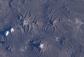
34:(this latter is in the lower center of this NASA image, with north to the top right corner).
167:
109:
401:
249:
183:
155:
133:
31:
224:
as the mountain is heavily glaciated. The composition of the volcano is largely
321:
220:
The date of its last eruption is unclear, but it is unlikely to be during the
25:
77:
64:
225:
170:, in the west of the Curahuara de Carangas Municipality, at the border with
229:
221:
163:
102:
45:
171:
116:
186:, west of the little lake Sura Pata, south-east of the mountains
232:
362:
139:
127:
122:
108:
98:
93:
54:
44:
39:
18:
276:BIGM map 1:50,000 Nevados Payachata Hoja 5739-I
194:and Milluni and south of the little lake named
174:. Patilla Pata lies south-west of the mountain
382:
8:
389:
375:
15:
428:Volcanoes of La Paz Department (Bolivia)
266:
178:, north-east of the lake Q'asiri Quta
272:
270:
7:
350:
348:
361:. You can help Knowledge (XXG) by
201:The river Junt'uma K'uchu (Aymara
14:
228:, but there are also a number of
438:Oruro Department geography stubs
24:
30:Patilla Pata is located NW of
1:
423:Volcanoes of Oruro Department
213:corner, "warm water corner",
50:5,324 m (17,467 ft)
255:List of volcanoes in Bolivia
433:Pleistocene stratovolcanoes
454:
408:Stratovolcanoes of Bolivia
347:
23:
327:Global Volcanism Program
166:. It is situated in the
332:Smithsonian Institution
287:"Curahuara de Carangas"
357:location article is a
418:Polygenetic volcanoes
78:18.06111°S 69.05667°W
413:Subduction volcanoes
293:on November 11, 2014
83:-18.06111; -69.05667
303:(unnamed, south of
74: /
40:Highest point
370:
369:
182:and the mountain
149:
148:
445:
391:
384:
377:
355:Oruro Department
349:
341:
339:
338:
308:
302:
300:
298:
289:. Archived from
283:
277:
274:
245:Jach'a Kunturiri
176:Jisk'a Kunturiri
160:Oruro Department
112:
89:
88:
86:
85:
84:
79:
75:
72:
71:
70:
67:
28:
16:
453:
452:
448:
447:
446:
444:
443:
442:
398:
397:
396:
395:
345:
336:
334:
320:
317:
312:
311:
296:
294:
285:
284:
280:
275:
268:
263:
241:
215:Junthuma Khuchu
180:(Khasiri Kkota)
168:Sajama Province
110:
82:
80:
76:
73:
68:
65:
63:
61:
60:
35:
12:
11:
5:
451:
449:
441:
440:
435:
430:
425:
420:
415:
410:
400:
399:
394:
393:
386:
379:
371:
368:
367:
343:
342:
322:"Patilla Pata"
316:
313:
310:
309:
278:
265:
264:
262:
259:
258:
257:
252:
247:
240:
237:
147:
146:
143:
137:
136:
131:
125:
124:
120:
119:
114:
106:
105:
100:
96:
95:
91:
90:
58:
52:
51:
48:
42:
41:
37:
36:
29:
21:
20:
13:
10:
9:
6:
4:
3:
2:
450:
439:
436:
434:
431:
429:
426:
424:
421:
419:
416:
414:
411:
409:
406:
405:
403:
392:
387:
385:
380:
378:
373:
372:
366:
364:
360:
356:
351:
346:
333:
329:
328:
323:
319:
318:
314:
306:
297:September 14,
292:
288:
282:
279:
273:
271:
267:
260:
256:
253:
251:
248:
246:
243:
242:
238:
236:
234:
231:
227:
223:
218:
216:
212:
208:
204:
199:
197:
193:
189:
185:
184:Qullqi Warani
181:
177:
173:
169:
165:
161:
157:
156:stratovolcano
153:
144:
142:
141:Last eruption
138:
135:
134:Stratovolcano
132:
130:
129:Mountain type
126:
121:
118:
115:
113:
107:
104:
101:
97:
92:
87:
59:
57:
53:
49:
47:
43:
38:
33:
32:Nevado Sajama
27:
22:
17:
363:expanding it
352:
344:
335:. Retrieved
325:
304:
295:. Retrieved
291:the original
281:
219:
214:
210:
206:
202:
200:
196:Ch'iyar Quta
179:
152:Patilla Pata
151:
150:
111:Parent range
19:Patilla Pata
305:Chiar Kkota
205:warm, hot,
188:Laram Q'awa
81: /
56:Coordinates
402:Categories
337:2021-06-29
261:References
69:69°03′24″W
66:18°03′40″S
226:andesitic
192:Kunturiri
94:Geography
46:Elevation
239:See also
230:basaltic
222:Holocene
99:Location
315:Sources
235:flows.
209:water,
164:Bolivia
158:in the
145:Unknown
123:Geology
103:Bolivia
250:Sajama
211:k'uchu
203:junt'u
353:This
172:Chile
154:is a
117:Andes
359:stub
299:2014
233:lava
207:uma
162:in
404::
330:.
324:.
269:^
198:.
190:,
390:e
383:t
376:v
365:.
340:.
307:)
301:.
Text is available under the Creative Commons Attribution-ShareAlike License. Additional terms may apply.