62:
48:
831:
87:
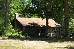
276:, was acquired by the state in 1929 from the Borden family, who had operated a milk condensing factory, the first of its type, on the pond's shore. The facilities of the park were largely established by the CCC crews established in the camp between 1933 and 1937. This building served as the administrative headquarters for the camp, and has seen a variety of mainly administrative uses by the state parks department since then. It is one of the best-preserved CCC-built buildings in the state.
842:
94:
69:
269:
structure, built of stone and wood, and covered by a cross-gabled roof. It has a T shape, with a deeply set porch under the east-facing gable. Its walls are mainly rubblestone, as are the porch supports. Roughly dressed granite steps lead to the porch at the center. The gable above the porch has exposed wooden rafters, and bracing beams at its front.
268:
The
Paugnut Forest Administration Building is located on the east side of Burr Pond State Park, in a cluster of administrative buildings located on the site of the former CCC camp. This area is located northeast of the main parking and beach area of the park. The building is a 1-1/2 story
866:
720:
815:
751:
735:
881:
285:
725:
810:
756:
397:
777:
679:
710:
644:
609:
684:
589:
549:
374:
649:
639:
634:
614:
730:
564:
479:
599:
594:
469:
689:
654:
559:
534:
674:
624:
604:
579:
569:
554:
544:
529:
509:
484:
474:
464:
694:
669:
574:
514:
494:
489:
459:
449:
629:
584:
524:
499:
454:
761:
659:
539:
504:
715:
664:
619:
519:
886:
427:
412:
367:
443:
131:
61:
86:
871:
845:
360:
835:
407:
383:
313:
257:
34:
798:
876:
256:(CCC), it is one of the finest examples of Bungalow/Craftsman architecture built by the CCC in the state. It was listed on the
202:
253:
803:
782:
47:
249:
119:
417:
422:
402:
318:
273:
245:
115:
337:"National Register of Historic Places Inventory-Nomination: Paugnut Forest Administration Building"
342:
336:
207:
352:
208:
Connecticut State Park and Forest
Depression-Era Federal Work Relief Programs Structures TR
867:
Park buildings and structures on the
National Register of Historic Places in Connecticut
220:
860:
816:
University and college buildings listed on the
National Register of Historic Places
286:
National
Register of Historic Places listings in Litchfield County, Connecticut
146:
133:
882:
National
Register of Historic Places in Litchfield County, Connecticut
811:
List of jails and prisons on the
National Register of Historic Places
308:
356:
93:
68:
244:) is a historic building at 385 Burr Mountain Road in
791:
770:
744:
703:
436:
413:
History of the
National Register of Historic Places
390:
226:
213:
201:
193:
185:
170:
162:
125:
110:
444:List of U.S. National Historic Landmarks by state
836:National Register of Historic Places portal
368:
272:Burr Pond State Park, which is surrounded by
8:
887:Civilian Conservation Corps in Connecticut
375:
361:
353:
46:
384:U.S. National Register of Historic Places
35:U.S. National Register of Historic Places
297:
872:Government buildings completed in 1937
330:
328:
309:"National Register Information System"
303:
301:
238:Paugnut Forest Administration Building
27:Paugnut Forest Administration Building
18:
7:
314:National Register of Historic Places
258:National Register of Historic Places
799:National Historic Preservation Act
252:. Built in 1937 by a crew of the
14:
841:
840:
829:
92:
85:
67:
60:
752:Federated States of Micronesia
398:Architectural style categories
215:
1:
101:Show map of the United States
16:United States historic place
254:Civilian Conservation Corps
189:Civilian Conservation Corps
903:
804:Historic Preservation Fund
783:American Legation, Morocco
824:
745:Lists by associated state
214:NRHP reference
54:
45:
41:
32:
25:
21:
726:Northern Mariana Islands
339:. National Park Service.
194:Architectural style
166:0.7 acres (0.28 ha)
877:Torrington, Connecticut
264:Description and history
250:Torrington, Connecticut
242:Burr Pond Park Bungalow
120:Torrington, Connecticut
114:385 Burr Mountain Rd.,
76:Show map of Connecticut
721:Minor Outlying Islands
704:Lists by insular areas
418:Keeper of the Register
423:National Park Service
403:Contributing property
335:Mary McCahon (1985).
319:National Park Service
147:41.87028°N 73.09278°W
778:District of Columbia
274:Paugnut State Forest
246:Burr Pond State Park
116:Burr Pond State Park
344:Accompanying photos
152:41.87028; -73.09278
143: /
197:Bungalow/craftsman
854:
853:
408:Historic district
234:
233:
230:September 5, 1986
894:
844:
843:
834:
833:
832:
757:Marshall Islands
377:
370:
363:
354:
347:
340:
332:
323:
322:
305:
217:
181:
179:
158:
157:
155:
154:
153:
148:
144:
141:
140:
139:
136:
102:
96:
95:
89:
77:
71:
70:
64:
50:
19:
902:
901:
897:
896:
895:
893:
892:
891:
857:
856:
855:
850:
830:
828:
820:
787:
766:
740:
699:
432:
386:
381:
351:
350:
334:
333:
326:
321:. July 9, 2010.
307:
306:
299:
294:
282:
266:
240:(also known as
177:
175:
151:
149:
145:
142:
137:
134:
132:
130:
129:
106:
105:
104:
103:
100:
99:
98:
97:
80:
79:
78:
75:
74:
73:
72:
37:
28:
17:
12:
11:
5:
900:
898:
890:
889:
884:
879:
874:
869:
859:
858:
852:
851:
849:
848:
838:
825:
822:
821:
819:
818:
813:
808:
807:
806:
795:
793:
789:
788:
786:
785:
780:
774:
772:
768:
767:
765:
764:
759:
754:
748:
746:
742:
741:
739:
738:
736:Virgin Islands
733:
728:
723:
718:
713:
711:American Samoa
707:
705:
701:
700:
698:
697:
692:
687:
682:
677:
672:
667:
662:
657:
652:
647:
645:South Carolina
642:
637:
632:
627:
622:
617:
612:
610:North Carolina
607:
602:
597:
592:
587:
582:
577:
572:
567:
562:
557:
552:
547:
542:
537:
532:
527:
522:
517:
512:
507:
502:
497:
492:
487:
482:
477:
472:
467:
462:
457:
452:
447:
440:
438:
437:Lists by state
434:
433:
431:
430:
428:Property types
425:
420:
415:
410:
405:
400:
394:
392:
388:
387:
382:
380:
379:
372:
365:
357:
349:
348:
324:
296:
295:
293:
290:
289:
288:
281:
278:
265:
262:
232:
231:
228:
224:
223:
218:
211:
210:
205:
199:
198:
195:
191:
190:
187:
183:
182:
172:
168:
167:
164:
160:
159:
127:
123:
122:
112:
108:
107:
91:
90:
84:
83:
82:
81:
66:
65:
59:
58:
57:
56:
55:
52:
51:
43:
42:
39:
38:
33:
30:
29:
26:
23:
22:
15:
13:
10:
9:
6:
4:
3:
2:
899:
888:
885:
883:
880:
878:
875:
873:
870:
868:
865:
864:
862:
847:
839:
837:
827:
826:
823:
817:
814:
812:
809:
805:
802:
801:
800:
797:
796:
794:
790:
784:
781:
779:
776:
775:
773:
769:
763:
760:
758:
755:
753:
750:
749:
747:
743:
737:
734:
732:
729:
727:
724:
722:
719:
717:
714:
712:
709:
708:
706:
702:
696:
693:
691:
688:
686:
685:West Virginia
683:
681:
678:
676:
673:
671:
668:
666:
663:
661:
658:
656:
653:
651:
648:
646:
643:
641:
638:
636:
633:
631:
628:
626:
623:
621:
618:
616:
613:
611:
608:
606:
603:
601:
598:
596:
593:
591:
590:New Hampshire
588:
586:
583:
581:
578:
576:
573:
571:
568:
566:
563:
561:
558:
556:
553:
551:
550:Massachusetts
548:
546:
543:
541:
538:
536:
533:
531:
528:
526:
523:
521:
518:
516:
513:
511:
508:
506:
503:
501:
498:
496:
493:
491:
488:
486:
483:
481:
478:
476:
473:
471:
468:
466:
463:
461:
458:
456:
453:
451:
448:
445:
442:
441:
439:
435:
429:
426:
424:
421:
419:
416:
414:
411:
409:
406:
404:
401:
399:
396:
395:
393:
389:
385:
378:
373:
371:
366:
364:
359:
358:
355:
346:
345:
338:
331:
329:
325:
320:
316:
315:
310:
304:
302:
298:
291:
287:
284:
283:
279:
277:
275:
270:
263:
261:
259:
255:
251:
247:
243:
239:
229:
227:Added to NRHP
225:
222:
219:
212:
209:
206:
204:
200:
196:
192:
188:
184:
173:
169:
165:
161:
156:
128:
124:
121:
117:
113:
109:
88:
63:
53:
49:
44:
40:
36:
31:
24:
20:
650:South Dakota
640:Rhode Island
635:Pennsylvania
615:North Dakota
343:
312:
271:
267:
241:
237:
235:
771:Other areas
731:Puerto Rico
565:Mississippi
480:Connecticut
150: /
126:Coordinates
861:Categories
680:Washington
600:New Mexico
595:New Jersey
470:California
292:References
135:41°52′13″N
690:Wisconsin
655:Tennessee
560:Minnesota
535:Louisiana
260:in 1986.
138:73°5′34″W
846:Category
675:Virginia
625:Oklahoma
605:New York
580:Nebraska
570:Missouri
555:Michigan
545:Maryland
530:Kentucky
510:Illinois
485:Delaware
475:Colorado
465:Arkansas
280:See also
221:86001736
186:Built by
111:Location
792:Related
695:Wyoming
670:Vermont
575:Montana
515:Indiana
495:Georgia
490:Florida
460:Arizona
450:Alabama
176: (
630:Oregon
585:Nevada
525:Kansas
500:Hawaii
455:Alaska
391:Topics
762:Palau
660:Texas
540:Maine
505:Idaho
171:Built
716:Guam
665:Utah
620:Ohio
520:Iowa
341:and
236:The
178:1937
174:1937
163:Area
216:No.
203:MPS
863::
327:^
317:.
311:.
300:^
248:,
118:,
446::
376:e
369:t
362:v
180:)
Text is available under the Creative Commons Attribution-ShareAlike License. Additional terms may apply.