62:
55:
258:(PAD&W). Originally chartered in 1883 as the Thunder Bay Colonization Railway, the line changed its name and route in 1887 to tap the iron deposits of the Gunflint Range. Construction began in 1889, and by 1892 the rails had been laid to the Canadian terminus at Gunflint Lake and work had begun across the boundary. A US charter was obtained, known as the PAD&W of Minnesota, to allow construction to the mine and eventually to Ely to link with the
275:
and continued into the spring; this
American metropolis would be christened "Gunflint City." The promoter of this new town was the American Realty Company, the same company that owned many sections of land in the area. They would publish an elaborate plat map in early 1893 entitled "Gun Flint Iron Range" which spoke of the great promise of the area. Located at Gunflint City was a unique business established by
34:
279:"entrepreneur" Margaret "Mag" Matthews. Mag was a very well-known madame in Fort William and she was obviously hoping to cash in on the business generated by the railway and the iron mine. Her "Hotel de Marguerite" was completed in November 1892 and in January 1893 she received the first liquor license granted in
242:
In late 1886 an enterprise known as the
American Realty Company was incorporated in Minnesota. Several of its promoters had ties to the recently established State Bank of Minneapolis, namely John Paulson and Kristian Kortgaard. With financial backing from the bank, the American Realty Company would
274:
Located 350 metres southwest of the
Paulson shaft was a mining encampment established at same time that explorations in the area began. Eventually it was decided that this site would become a permanent settlement for the soon-to-be expansive mining operations. Work began in the late winter of 1892
265:
Explorations in T65, R4W began sometime in 1888, but really did not gather much steam until the railway began to approach the area in 1891. Work was concentrated in sections 28 and 29, three and a half miles southwest of the
Gunflint Narrows. Numerous test pits were dug to ascertain the quality of
239:. Conclusive evidence of the quality of iron in the area would not come until 1886 when Grand Marais pioneer Hazael "Henry" Mayhew made discoveries at the western end of the lake. This then attracted the attention of investors in the state capital.
266:
the ore, and eventually three timber-lined mine shafts were completed. The principal shaft, the "Paulson Mine," was located in the northeast quadrant of section 28 and was approximately one hundred and five feet deep.
676:
321:. The Forest Service used the fire as the impetus to create a new hiking trail. Opened in 2009 to commemorate the 100th anniversary of the Forest Service, the 3.3 mile
227:
The existence of iron bearing rocks in the
Gunflint Lake area was first mentioned as early as 1850. Eventually these deposits would be linked to the famous
457:
W. Emmons & F. Grout. Mineral
Resources of Minnesota #30 University of Minnesota Geological Survey Minneapolis: University of Minn Press, 1943 p.22-23
671:
686:
421:
Gunflint Lake Iron
Company Articles of Incorporation. Index of Corporations, 1:274, A-J, State of Minnesota Archives, Minnesota Historical Society
334:
255:
216:
314:
118:
54:
598:
322:
325:
allows hikers to walk along portions of the old railway grade and visit some of the shafts and test pits (but not the
Paulson shaft).
681:
661:
582:
259:
666:
292:
299:
466:
U.S. Grant. Geology of the Akeley Lake Plate
Geology of Minnesota Vol IV St. Paul: Pioneer Press, 1899 p.461-480
295:
367:
Ontario
Department of Mines Annual Report 1892-1894 Vol. 2-4 Toronto: Warwick Bros & Ruffer, 1893 p. 67-69
358:
Frank Holmes Minnesota in Three Centuries Vol 4 Mankato, MN: Publishing Society of Minnesota, 1908 p.381-382
208:
280:
244:
196:
86:
276:
376:
Willis Raff. Pioneers in the Wilderness Grand Marais, MN: Cook Cty Historical Society, 1981 p.147-156
291:
The Paulson Mine, as well as the other nearby shafts and test pits lie within the confines of the
313:
area was hit by an intense weather system that caused massive blowdowns, and became known as the
17:
254:
The mine required an outlet for its ore, and that would be provided by a Canadian line, the
498:
Willis Raff. Pioneers in the Wilderness Grand Marais, MN: Cook Cty Historical Society, 1981
586:
310:
303:
317:. In 2007 the area was burned by the Ham Lake Fire that originated at Ham Lake south the
339:
318:
262:. Work was completed in late 1892 and the line was opened for traffic in January 1893.
248:
236:
219:
was built to the mine in 1892 to access the ore, but both the mine and railway failed.
212:
655:
204:
106:
579:
228:
639:
627:
133:
120:
251:
would incorporate the Gunflint Lake Iron Company to mine the iron deposits.
200:
96:
33:
243:
purchase large tracts of land in Township 65, Range 4 West (T65, R4W) of
192:
158:
644:
632:
232:
439:
Ontario Department of Mines, Annual Report 1892-1894 Vol. 2-4 p. 67-69
247:. Later in 1892, Paulson and Kortgaard, along with Orrin D. Kinney of
516:
Aly Boltman. Finding Old Mag Grey County Historian. No.23 March 2010
507:
Diamond Litho-Pubg. Co. : Gun Flint Iron Range. Minneapolis,
525:
Elinor Barr Thunder Bay to Gunflint Thunder Bay: TBHMS, 1999
622:
494:
492:
490:
177:
169:
164:
154:
149:
112:
102:
92:
82:
43:
677:Buildings and structures in Cook County, Minnesota
430:Holmes, Minnesota in Three Centuries p.381-382
599:"Superior National Forest - Centennial Trail"
231:and this eastern portion which extended into
8:
26:
570:Thunder Bay Chronicle-Journal May 13, 2007
561:Thunder Bay Chronicle-Journal July 5, 1999
448:Raff, Pioneers in the Wilderness p.147-173
412:Raff, Pioneers in the Wilderness p.147-156
25:
623:"Port Arthur, Duluth and Western Railway"
640:"Gunflint Mines-Gunflint City, MN 1998"
580:Star Tribune Story on the Gunflint Fire
351:
335:Port Arthur, Duluth and Western Railway
217:Port Arthur, Duluth and Western Railway
7:
61:
23:Mine in Cook County, Minnesota, U.S.
315:Boundary Waters – Canadian derecho
14:
672:Former mines in the United States
298:. It is adjacent to the renowned
687:1888 establishments in Minnesota
60:
53:
32:
256:Port Arthur, Duluth and Western
628:"Paulson Mine, Minnesota 2012"
385:St. Paul Globe January 6, 1887
293:United States Forest Service's
260:Duluth and Iron Range Railroad
207:, 53 kilometres north-west of
1:
475:New York Times March 27, 1893
211:near the end of the historic
394:St. Paul Globe July 30, 1885
484:Duluth Tribune June 4, 1893
403:St. Paul Globe May 16, 1886
703:
300:Boundary Waters Canoe Area
38:Paulson Mine, October 2012
15:
48:
31:
682:Superior National Forest
296:Superior National Forest
16:Not to be confused with
662:Iron mines in Minnesota
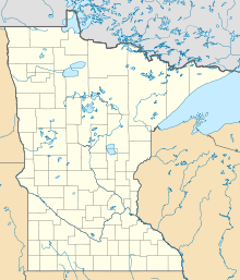
209:Grand Marais, Minnesota
134:48.086827°N 90.840975°W
277:Fort William, Ontario
139:48.086827; -90.840975
74:Location in Minnesota
667:Geology of Minnesota
552:FWJ 30 November 1892
543:FWJ 26 November 1892
235:became known as the
642:, by D. Battistel.
630:, by D. Battistel.
534:FWJ 5 November 1892
309:In 1999 the entire
130: /
28:
585:2008-07-20 at the
18:Paulsens Gold Mine
302:, as well as the
229:Mesabi Iron Range
185:
184:
694:
610:
609:
607:
606:
595:
589:
577:
571:
568:
562:
559:
553:
550:
544:
541:
535:
532:
526:
523:
517:
514:
508:
505:
499:
496:
485:
482:
476:
473:
467:
464:
458:
455:
449:
446:
440:
437:
431:
428:
422:
419:
413:
410:
404:
401:
395:
392:
386:
383:
377:
374:
368:
365:
359:
356:
323:Centennial Trail
195:mine located in
145:
144:
142:
141:
140:
135:
131:
128:
127:
126:
123:
64:
63:
57:
36:
29:
702:
701:
697:
696:
695:
693:
692:
691:
652:
651:
619:
614:
613:
604:
602:
597:
596:
592:
587:Wayback Machine
578:
574:
569:
565:
560:
556:
551:
547:
542:
538:
533:
529:
524:
520:
515:
511:
506:
502:
497:
488:
483:
479:
474:
470:
465:
461:
456:
452:
447:
443:
438:
434:
429:
425:
420:
416:
411:
407:
402:
398:
393:
389:
384:
380:
375:
371:
366:
362:
357:
353:
348:
331:
311:Boundary Waters
304:Kekekabic Trail
289:
272:
225:
138:
136:
132:
129:
124:
121:
119:
117:
116:
78:
77:
76:
75:
72:
71:
70:
69:
65:
39:
24:
21:
12:
11:
5:
700:
698:
690:
689:
684:
679:
674:
669:
664:
654:
653:
650:
649:
637:
625:
618:
617:External links
615:
612:
611:
590:
572:
563:
554:
545:
536:
527:
518:
509:
500:
486:
477:
468:
459:
450:
441:
432:
423:
414:
405:
396:
387:
378:
369:
360:
350:
349:
347:
344:
343:
342:
340:Gunflint Range
337:
330:
327:
319:Gunflint Trail
288:
285:
271:
268:
237:Gunflint Range
224:
221:
213:Gunflint Trail
183:
182:
179:
175:
174:
171:
167:
166:
162:
161:
156:
152:
151:
147:
146:
114:
110:
109:
104:
100:
99:
94:
90:
89:
84:
80:
79:
73:
67:
66:
59:
58:
52:
51:
50:
49:
46:
45:
41:
40:
37:
22:
13:
10:
9:
6:
4:
3:
2:
699:
688:
685:
683:
680:
678:
675:
673:
670:
668:
665:
663:
660:
659:
657:
647:
646:
641:
638:
635:
634:
629:
626:
624:
621:
620:
616:
601:. Fs.usda.gov
600:
594:
591:
588:
584:
581:
576:
573:
567:
564:
558:
555:
549:
546:
540:
537:
531:
528:
522:
519:
513:
510:
504:
501:
495:
493:
491:
487:
481:
478:
472:
469:
463:
460:
454:
451:
445:
442:
436:
433:
427:
424:
418:
415:
409:
406:
400:
397:
391:
388:
382:
379:
373:
370:
364:
361:
355:
352:
345:
341:
338:
336:
333:
332:
328:
326:
324:
320:
316:
312:
307:
305:
301:
297:
294:
286:
284:
282:
278:
270:Gunflint City
269:
267:
263:
261:
257:
252:
250:
246:
240:
238:
234:
230:
223:Early history
222:
220:
218:
214:
210:
206:
205:United States
202:
198:
194:
190:
180:
176:
172:
168:
163:
160:
157:
153:
148:
143:
115:
111:
108:
107:United States
105:
101:
98:
95:
91:
88:
85:
81:
56:
47:
42:
35:
30:
19:
643:
631:
603:. Retrieved
593:
575:
566:
557:
548:
539:
530:
521:
512:
503:
480:
471:
462:
453:
444:
435:
426:
417:
408:
399:
390:
381:
372:
363:
354:
308:
290:
273:
264:
253:
241:
226:
191:is a former
189:Paulson Mine
188:
186:
68:Paulson Mine
27:Paulson Mine
281:Cook County
245:Cook County
197:Cook County
137: /
113:Coordinates
87:Cook County
656:Categories
605:2022-09-17
346:References
150:Production
125:90°50′28″W
122:48°05′13″N
201:Minnesota
97:Minnesota
583:Archived
329:See also
193:iron ore
159:Iron ore
155:Products
83:Location
44:Location
645:YouTube
633:YouTube
233:Ontario
165:History
103:Country
215:. The
178:Closed
170:Opened
287:Today
93:State
187:The
181:1893
173:1888
249:Ely
658::
489:^
306:.
283:.
203:,
199:,
648:.
636:.
608:.
20:.
Text is available under the Creative Commons Attribution-ShareAlike License. Additional terms may apply.