63:
219:
Wildlife
Conservation Department. It does not maintain any lodge, bungalow or such type of facility for tourists inside Peak Wilderness sanctuary in order to safeguard the purity of this forest. Yet, there is no restriction for eco-tourists to enter the sanctuary after obtaining permission from Sri Lanka Wildlife Conservation Department. Entering the sanctuary during the rain season is at the tourist’s own risk because of the unforeseen downpours and instant floods lead to life-risk situations.
43:
70:
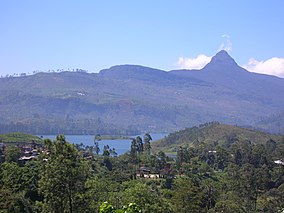
211:) mountain. A huge forest area that belonged to the Peak Wilderness was cut down and cleared during the British colonial rule in Sri Lanka (1815–1948) to gain land for the massive tea estates which are still functioning in Nuwara Eliya district. The remaining portion of the Peak Wilderness was declared a wildlife sanctuary on October 25, 1940.
214:
The contours of "Sri Pada" Peak
Wilderness vary from 1000 to 7360 feet above sea level. Therefore, it possesses unusual geographical formations compared to the other natural reserves of the island. Bena Samanala (6579 ft), Dotalugala, Detanagala, are some of the taller mountains in the Peak
218:
Out of the three access routes; Hatton route, Kuruwita route and
Palabaddala route, which Buddhist devotees and other tourists use to reach the Adam’s Peak, Kuruwita and Palabaddala routes go right across the Peak Wilderness sanctuary. This forest area is entirely under the control of Sri Lanka
215:
Wilderness. It is also the birthplace of Kelani, Kalu, Walave rivers and many tributaries of the river
Mahaweli which make waterfalls such as Dotalu falls, Geradi falls, Galagama falls (655 ft), and Mapanana falls (330 ft) inside the sanctuary.
235:
There are no specific boundaries for the Peak
Wilderness sanctuary. Most boundaries are marked by plantations owned by the Government and the private sector. The eastern boundary is clear and connected to
348:
62:
353:
170:
368:
358:
119:
363:
317:
184:
28:
267:
241:
89:
207:"Sri Pada" Peak Wilderness Sanctuary is a tropical rainforest spread over 224 square kilometers around the Sri Pada (
93:
32:
254:
197:
237:
208:
48:
342:
258:
was rediscovered in this sanctuary after it was thought to be extinct for 133 years.
321:
134:
121:
201:
107:
97:
227:
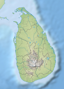
It is located within the
Sabaragamuwa mountain range in the central hills.
204:. It is the third largest (by area) of the 50 sanctuaries in the country.
180:
288:"World Heritage Committee inscribes two new sites on World Heritage List"
42:
295:
287:
176:
166:
158:
150:
113:
103:
85:
21:
181:1203-001: "Peak Wilderness Protected Area (PWPA)"
69:
349:Protected areas in Central Province, Sri Lanka
8:
47:"Sri Pada" Peak Wilderness encompasses the
18:
252:In October 2009, the world's rarest toad
154:22,379.1 ha (86.406 sq mi)
354:Protected areas in Sabaragamuwa Province
279:
7:
84:
77:"Sri Pada" Peak Wilderness Sanctuary
22:"Sri Pada" Peak Wilderness Sanctuary
369:Protected areas established in 1940
171:Department of Wildlife Conservation
14:
359:Wildlife sanctuaries of Sri Lanka
68:
61:
41:
157:
102:
185:Central Highlands of Sri Lanka
1:
364:1940 establishments in Ceylon
268:Protected areas of Sri Lanka
183:since 2010 (within the site
242:Horton Plains National Park
16:Nature reserve in Sri Lanka
385:
194:Peak Wilderness Sanctuary
56:
40:
26:
177:World Heritage site
238:Pidurutalagala mountain
318:"Article from Divaina"
33:strict nature reserve
135:6.81306°N 80.48444°E
167:Governing body
131: /
255:Adenomus kandianus
191:
190:
140:6.81306; 80.48444
104:Nearest city
376:
333:
332:
330:
329:
320:. Archived from
314:
308:
307:
305:
303:
284:
162:October 25, 1940
146:
145:
143:
142:
141:
136:
132:
129:
128:
127:
124:
72:
71:
65:
45:
19:
384:
383:
379:
378:
377:
375:
374:
373:
339:
338:
337:
336:
327:
325:
316:
315:
311:
301:
299:
298:. July 30, 2010
286:
285:
281:
276:
264:
250:
233:
225:
198:natural reserve
139:
137:
133:
130:
125:
122:
120:
118:
117:
81:
80:
79:
78:
75:
74:
73:
52:
36:
17:
12:
11:
5:
382:
380:
372:
371:
366:
361:
356:
351:
341:
340:
335:
334:
309:
278:
277:
275:
272:
271:
270:
263:
260:
249:
246:
232:
229:
224:
221:
189:
188:
178:
174:
173:
168:
164:
163:
160:
156:
155:
152:
148:
147:
115:
111:
110:
105:
101:
100:
87:
83:
82:
76:
67:
66:
60:
59:
58:
57:
54:
53:
46:
38:
37:
27:
24:
23:
15:
13:
10:
9:
6:
4:
3:
2:
381:
370:
367:
365:
362:
360:
357:
355:
352:
350:
347:
346:
344:
324:on 2009-11-06
323:
319:
313:
310:
297:
293:
289:
283:
280:
273:
269:
266:
265:
261:
259:
257:
256:
247:
245:
243:
239:
230:
228:
222:
220:
216:
212:
210:
205:
203:
199:
195:
186:
182:
179:
175:
172:
169:
165:
161:
153:
149:
144:
116:
112:
109:
106:
99:
95:
91:
88:
64:
55:
50:
44:
39:
34:
30:
29:IUCN category
25:
20:
326:. Retrieved
322:the original
312:
300:. Retrieved
291:
282:
253:
251:
234:
226:
217:
213:
206:
193:
192:
94:Sabaragamuwa
240:region and
209:Adam's Peak
159:Established
138: /
114:Coordinates
96:provinces,
49:Adam's Peak
343:Categories
328:2009-11-02
292:unesco.org
274:References
231:Boundaries
126:80°29′04″E
51:(Sri Pada)
202:Sri Lanka
123:6°48′47″N
108:Ratnapura
98:Sri Lanka
302:1 August
262:See also
223:Location
86:Location
90:Central
296:UNESCO
248:Fauna
196:is a
304:2010
151:Area
92:and
31:Ia (
200:in
345::
294:.
290:.
244:.
331:.
306:.
187:)
35:)
Text is available under the Creative Commons Attribution-ShareAlike License. Additional terms may apply.