29:
76:
46:
83:
53:
567:
710:
314:
in 2000. In 2006, an environmental evaluation of the lake concluded "the nitrate concentration of 17 μeq/L to be too high to come from atmospheric deposition alone."
700:
221:
122:
705:
362:
300:
75:
720:
296:
45:
353:
311:
651:
513:
197:
358:
488:
449:
279:) to the east, and the lake level of 9,488 ft (2,892 m) is over 1,000 ft (300 m) below the summits of
715:
540:
414:
408:
323:
284:
272:
590:
287:(south). The namesake Peeler Lake Trail of 1.5 mi (2.4 km) from the east reaches the lake from the
348:
276:
108:
28:
671:
307:
292:
619:
288:
382:
268:
253:
668:
682:
501:
209:
647:
509:
443:
245:
237:
229:
201:
641:
535:
256:
280:
225:
154:
694:
264:
217:
205:
505:
495:
260:
249:
213:
568:"Bridgeport Ranger Station Announces Fall Office Hours & Campground Closures"
403:: Unlike Peeler Lake's drainage to both the Pacific and a Great Basin sink, the
241:
233:
193:
464:
451:
429:
416:
137:
124:
310:(as was Barney Lake downstream to the east), and the lake was added to the
598:
306:
Peeler Lake was named in 1925 for Barney Peeler (1833–1920) of nearby
490:
Wild
Northern California: A Guide to 41 Roadless Recreation Areas
216:
sills of similar elevation to respectively drain westward to the
683:
http://165.83.37.17/air/Pubs/pdf/EvalAcidificationNineParks.pdf
303:
issues overnight permits for the backcountry area of the lake.
212:, Peeler Lake's inflow is sufficient for outlet streams over 2
667:: For Barney Peeler, this source cites "SCB 12:126" (
711:
Mountain passes of the Sierra Nevada (United States)
180:
176:
168:
164:
153:
114:
104:
21:
477:) are by definition not in the Pacific Watershed.
115:
640:Gudde, Erwin G. Gudde; Bright, William (2004).
16:Lake in the state of California, United States
8:
18:
407:lakes on the Great Basin Divide such as
363:United States Department of the Interior
570:. USDA Forest Service. 9 September 2011
335:
390:(Map). US Forest Service. August 2007.
343:
341:
339:
7:
354:Geographic Names Information System
312:Geographic Names Information System
82:
52:
14:
706:Lakes of Mono County, California
701:Humboldt–Toiyabe National Forest
547:Humboldt-Toiyabe National Forest
81:
74:
51:
44:
27:
672:identified the eponym in 1926).
359:United States Geological Survey
167:
1:
620:"Barney Peeler (1833 - 1920)"
275:) and the Sierra Escarpment (
103:
95:Show map of the United States
721:Lakes of Northern California
597:. Tripod.com. Archived from
291:parking at the west side of
200:and on the west edge of the
324:List of lakes in California
737:
465:38.8276056°N 120.0943861°W
301:Bridgeport Ranger Station
172:9,488 feet (2,892 m)
38:
26:
470:38.8276056; -120.0943861
430:38.131863°N 119.458776°W
289:Robinson Creek Trailhead
240:) and eastward into the
33:Peeler Lake in July 2009
349:"Peeler Lake (1652854)"
198:Toiyabe National Forest
109:Mono County, California
643:California Place Names
595:Fly Fishing the Sierra
435:38.131863; -119.458776
138:38.12056°N 119.46778°W
65:Show map of California
487:Adkison, Ron (2001).
196:landform within the
143:38.12056; -119.46778
716:Lakes of California
669:Francis P. Farquhar
536:"Peeler Lake Trail"
461: /
426: /
134: /
259:). Peeler Lake's
238:San Francisco Bays
230:San Joaquin Rivers
210:Great Basin Divide
204:. One of the few
384:Hoover Wilderness
267:between the west
244:(Robinson Creek,
202:Hoover Wilderness
187:
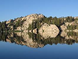
186:
169:Surface elevation
728:
685:
680:
674:
663:
661:
660:
637:
631:
630:
628:
627:
616:
610:
609:
607:
606:
589:Schalla, Steve.
586:
580:
579:
577:
575:
564:
558:
557:
555:
554:
544:
532:
526:
525:
523:
522:
499:
484:
478:
476:
475:
473:
472:
471:
466:
462:
459:
458:
457:
454:
441:
440:
438:
437:
436:
431:
427:
424:
423:
422:
419:
398:
392:
391:
389:
379:
373:
372:
370:
369:
345:
149:
148:
146:
145:
144:
139:
135:
132:
131:
130:
127:
117:
96:
85:
84:
78:
66:
55:
54:
48:
31:
19:
736:
735:
731:
730:
729:
727:
726:
725:
691:
690:
689:
688:
681:
677:
658:
656:
654:
639:
638:
634:
625:
623:
618:
617:
613:
604:
602:
588:
587:
583:
573:
571:
566:
565:
561:
552:
550:
538:
534:
533:
529:
520:
518:
516:
493:
486:
485:
481:
469:
467:
463:
460:
455:
452:
450:
448:
447:
434:
432:
428:
425:
420:
417:
415:
413:
412:
409:Cirque Mountain
399:
395:
387:
381:
380:
376:
367:
365:
347:
346:
337:
332:
320:
281:Cirque Mountain
273:Tuolumne County
222:Rancheria Creek
206:bodies of water
157: countries
142:
140:
136:
133:
128:
125:
123:
121:
120:
100:
99:
98:
97:
94:
93:
92:
91:
90:
86:
69:
68:
67:
64:
63:
62:
61:
60:
56:
34:
17:
12:
11:
5:
734:
732:
724:
723:
718:
713:
708:
703:
693:
692:
687:
686:
675:
652:
632:
622:. ancestry.com
611:
581:
559:
541:Forest Service
527:
514:
479:
393:
374:
334:
333:
331:
328:
327:
326:
319:
316:
185:
184:
182:
178:
177:
174:
173:
170:
166:
165:
162:
161:
158:
151:
150:
118:
112:
111:
106:
102:
101:
88:
87:
80:
79:
73:
72:
71:
70:
58:
57:
50:
49:
43:
42:
41:
40:
39:
36:
35:
32:
24:
23:
15:
13:
10:
9:
6:
4:
3:
2:
733:
722:
719:
717:
714:
712:
709:
707:
704:
702:
699:
698:
696:
684:
679:
676:
673:
670:
666:
655:
653:9780520242173
649:
645:
644:
636:
633:
621:
615:
612:
601:on 2012-10-04
600:
596:
592:
585:
582:
569:
563:
560:
549:. fs.usda.gov
548:
542:
537:
531:
528:
517:
515:9781560447818
511:
507:
503:
497:
492:
491:
483:
480:
474:
456:120°5′39.79″W
453:38°49′39.38″N
445:
439:
410:
406:
402:
397:
394:
386:
385:
378:
375:
364:
360:
356:
355:
350:
344:
342:
340:
336:
329:
325:
322:
321:
317:
315:
313:
309:
304:
302:
298:
294:
290:
286:
282:
278:
274:
270:
266:
265:mountain pass
262:
258:
255:
251:
250:Walker Rivers
247:
243:
239:
235:
231:
227:
223:
219:
218:Pacific Ocean
215:
211:
207:
203:
199:
195:
191:
183:
179:
175:
171:
163:
160:United States
159:
156:
152:
147:
119:
113:
110:
107:
77:
47:
37:
30:
25:
20:
678:
664:
657:. Retrieved
642:
635:
624:. Retrieved
614:
603:. Retrieved
599:the original
594:
591:"Twin Lakes"
584:
572:. Retrieved
562:
551:. Retrieved
546:
530:
519:. Retrieved
506:Globe Pequot
502:Falcon Guide
496:Google books
489:
482:
404:
400:
396:
383:
377:
366:. Retrieved
352:
305:
297:Mono Village
283:(north) and
214:Sierra Crest
189:
188:
468: /
433: /
421:119°27′32″W
299:), and the
285:Crown Point
277:Mono County
261:saddle area
254:Walker Lake
246:East Walker
242:Great Basin
190:Peeler Lake
141: /
129:119°28′04″W
116:Coordinates
89:Peeler Lake
59:Peeler Lake
22:Peeler Lake
695:Categories
659:2011-11-14
626:2011-11-14
605:2011-11-14
553:2011-11-14
521:2011-11-14
418:38°07′55″N
368:2011-11-14
330:References
308:Bridgeport
295:(formerly
293:Twin Lakes
194:California
181:References
126:38°07′14″N
405:endorheic
574:17 April
543:webpage)
444:Cup Lake
318:See also
226:Tuolumne
105:Location
271:slope (
208:on the
650:
512:
442:) and
269:Sierra
248:&
236:&
234:Suisun
232:, and
228:&
388:(PDF)
263:is a
192:is a
155:Basin
665:NOTE
648:ISBN
576:2016
510:ISBN
401:NOTE
257:sink
697::
646:.
593:.
545:.
508:.
504:.
500:.
361:,
357:.
351:.
338:^
252:,
224:,
662:.
629:.
608:.
578:.
556:.
539:(
524:.
498:)
494:(
446:(
411:(
371:.
220:(
Text is available under the Creative Commons Attribution-ShareAlike License. Additional terms may apply.