560:"After a short run through rapid water in the river, the way lies through Quakish Lake, two miles ; thence one mile through furious rapids, that require all the strength and skill of practised boatmen to ascend them by poling, to North Twin Dam ; thence a mile more of river, or — as a reach of running stream connecting two lakes is here termed — of "thoroughfare," leads into North Twin Lake, four miles long, from which another of a few rods only opens into Pemadumcook Lake, largest of the chain and ten miles in length. About three miles of boating in this lake reaches a part of it called Deep Cove, two miles long and terminating in a passage into Ambejijis Lake, which is two miles long. It may be approached also by running on Pemadumcook about four miles, nearly to Gull Rock, opposite the outlet of Lower Joe Merry Lake ; and thence by a channel, sometimes troublesomely shallow, two miles to the entrance into Ambejijis. Here on a point stands a log camp, dignified with the name of the Ambejijis House or Boom House, from the boom that stretches across the passage. This and a similar one at North Twin Dam, are the only roofs between the Head of Chesuncook and 'Old Fowler's,' a distance of more than sixty miles."
544:"At noon we floated out upon Lake Pemadumcook, the largest bulge of the Penobscot, and irregular as the verb To Be. Lumbermen name it Bammydumcook : Iglesias insisted upon this as the proper reading ; and as he was the responsible man of the party, I accepted it. Woods, woody hills, and woody mountains surround Bammydumcook. I have no doubt parts of it are pretty, and will be famous in good time ; but we saw little. By the time we were fairly out in the lake and away from the sheltering shore, a black squall to windward, hiding all the West, warned us to fly, for birches swamp in squalls. We deemed that Birch, having brought us through handsomely, deserved a better fate : swamped it must not be. We plied paddle valiantly, and were almost safe behind an arm of the shore when the storm overtook us, and in a moment more, safe, with a canoe only half- full of Bammydumcook water. It is easy to speak in scoffing tone ; but when that great roaring blackness sprang upon us, and the waves, showing their white teeth, snarled around, we were far from being in the mood to scoff. It is impossible to say too much of the charm of this gentle scenery, mingled with the charm of this adventurous sailing."
327:. The West Branch enters the northwest corner of Ambajejus, and the current flows south through that lake. The channel passes Deep Cove on the east and Porus Islands to the west. The river channel then passes east through the east end of Pemadumcook into the head of North Twin Lake at Indian Point. The channel then follows a southeasterly course across North Twin Lake, staying between Perrow Point and Spring Island, and then veering eastward past Snake Point in sight of the settlement of Norcross. The channel then passes due east through the Elbow to North Twin dam. The length of the channel is about 11.5 miles (20 km). The combined length of the lake from the North Twin Dam, following the channel in reverse to the Porus Islands and thence to the northwest corner of Pemadumcook at Nahmakanta Stream, is nearly 14 miles (23 km). There is a large boulder in Nahmakanta Stream where the
348:
water is quite high one need not concern oneself about boulders in the middle of the lake. Exceptions include but are not restricted to a large reef at the west end of South Twin Lake that runs north and south and a large rock pile 1 mile (1.6 km) north-northwest of
Partridge Cove which is usually marked. There are a couple of reefs in North Twin and a long reef about 600 feet (180 m) north of Indian Point Island. The Porus Islands and Deep Cove have plenty of boulders. There is a surprising rock pile about 0.5 miles (0.80 km) east of Jo Mary island.
46:
76:
352:
529:"After poling up half a mile of river, or thoroughfare we rowed a mile across the foot of Pamadumcook Lake, which is the name given on the map to this whole chain of lakes, as if there was but one, though they are, in each instance distinctly separated by a reach of the river, with its narrow and rocky channel and its rapids. This lake which is one of the largest, stretched northwest ten miles, to hills and mountains in the distance."
83:
53:
29:
343:
are all south of Spring Island. The channel between North and South Twin Lake between the western shore and these islands runs north and south and is called the
Narrows. The islands in South Twin include the Rock Pile which marks the southwest corner of the archipelago of islands separating North
347:
The deepest parts of the lake are 101 feet (31 m), about 0.5 miles (800 m) southwest of Moose Island in
Pemadumcook, and 92 feet (28 m), just north of the ridge in Ambajejus Lake. There are numerous rocks in the lake, and the spring runoff brings many logs floating about. If the
338:
is "lake with gravelly or sandy bottom or sand bars". The principal islands in the lake include the Porus
Islands in Pemadumcook, Jo Mary Island on the south side of that lake and Moose Island and Gull Rock on the north side of the lake. The Porus islands, while principally in Pemadumcook, do
344:
and South Twin Lakes, Peanut Island, and the reef that runs between it and the Rock Pile to the north. There are a couple of islands in
Partridge Cove at the southeast corner of the lake, and Oak Island and several other islands are on the south side of the lake at the mouth of Ragged Brook.
695:"A Description of Natardin or Catardin Moun- -tain – being an extract from a letter written by Charles Turner Jun. Esq. in the summer of 1804 which was one of the several seasons in which he has been employed in the interior, and North of the District of Maine, as a Surveyor"
292:. If one takes a landscape picture from that summit, these lakes span the distance from the Piscataquis Mountains in the west to North Twin dam on Elbow Lake in the east. It is the fifth-largest lake system in Maine, exceeded only by
637:
402:
209,000 acres (850 km), and to the west are the 43,000-acre (170 km) Nahmakanta Public lands. There is a state-sponsored boat access ramp in
Partridge Cove off Route 11 at
644:
368:
at
Ambajejus, Jo Mary Stream on the south side of Pemadumcook, and Nahmakanta Stream at the northwest corner of Pemadumcook. Twitchell Brook enters the lake near a point where the
505:
An early document about this lake is the Large Crown Map from the 1764 Chadwick Survey by Joseph
Chadwick, a surveyor for the British. Chadwick undertook a survey of the
620:
995:
848:
576:
433:. Water clarity as indicated by the Secchi Disk: Range of 2007 Average Secchi Disk Transparency is 4.8 meters. The above indicates how far down one can see.
45:
387:
road gives access to
Spencer Cove at the northeast end of Ambajejus Lake about 8 miles (13 km) from Millinocket. A dike at Spencer Cove created by the
75:
1771:
515:., on the view from Katahdin in 1804 describes it by writing, "and south of it (Chesuncook); a large lake N. of. The E. end of the Piscataquis Mountains."
1776:
795:
125:
1714:
1707:
1104:
932:
392:
379:
on the east side. This runs past
Partridge Cove at the southeast corner of South Twin Lake and then serves the area up to Norcross.
405:
974:
827:
820:
701:
669:
613:
1609:
988:
841:
788:
1637:
960:
904:
876:
388:
1090:
981:
834:
509:. The chain of lakes appears under the name "Bennedumcook" as a large lake in the Penobscot River above Quakish Lake.
320:
1781:
339:
divide Pemadumcook to the west and south from Ambajejus to the north. The islands separating North Twin Lake from
553:
111:
1749:
1786:
967:
953:
897:
781:
1791:
1651:
1318:
1195:
383:
is about 5 miles (8 km) east of Norcross on Maine Route 11. The paved portion of the Millinocket–
340:
316:
308:
at 20,300 acres (82 km). The Pemadumcook Chain of Lakes occupy 18,300 acres (74 km). Individually
108:
1728:
1700:
571:
The Penobscot Boom and the Development of the West Branch of the Penobscot River for Log Driving 1825–1931
309:
305:
391:
prevents water from flowing from Ambajejus Lake, spillway elevation 492 feet (150 m), into adjacent
1311:
1139:
594:
1160:
1076:
862:
454:
376:
331:
appears on the south bank of the stream. It is not prudent to take a motorboat west of the boulder.
1735:
1658:
1514:
1437:
1388:
1153:
718:
518:
364:
The inlets to the lake are at Ragged Brook and Lincoln Brook on South Twin, the West Branch of the
351:
1591:
1556:
1535:
1458:
1360:
1209:
1062:
918:
869:
512:
380:
288:
The Pemadumcook chain of lakes forms the largest body of water in view as one gazes south from
280:
is rendered by the United States Geographical Board in an 1897 decision as "Pemadumcook Lake".
1686:
1623:
1616:
1584:
1395:
1297:
1283:
1269:
1216:
1097:
1083:
1020:
925:
890:
855:
738:
533:
399:
384:
369:
328:
243:
1665:
1507:
1339:
1325:
1276:
1055:
1048:
1034:
1027:
335:
1721:
1672:
1644:
1528:
1486:
1479:
1430:
1346:
1304:
1111:
1041:
883:
804:
506:
494:
490:
474:
450:
365:
324:
301:
1679:
1542:
1451:
1423:
1402:
1374:
1353:
1332:
1248:
1188:
486:
458:
293:
289:
169:
1765:
1570:
1563:
1549:
1521:
1493:
1472:
1444:
1416:
1381:
1367:
1290:
1262:
1255:
1241:
1167:
1118:
1069:
1013:
946:
482:
261:
175:
157:
1500:
1234:
1181:
911:
470:
462:
162:
694:
759:
742:
722:
673:
1630:
1577:
1465:
1146:
939:
466:
442:
297:
1742:
1409:
1202:
1174:
1125:
446:
420:
407:
140:
127:
1693:
773:
315:
The series of lakes are named Ambajejus, Elbow, North Twin, Pemadumcook and
28:
478:
398:
To the north of the chain of lakes, but not contiguous with it, is
350:
257:
312:
is larger than Pemadumcook, but it is not larger than the chain.
777:
372:
provides a view of the lake, but there is no inlet.
1601:
1226:
1005:
812:
233:
225:
217:
209:
201:
193:
185:
181:
168:
156:
117:
104:
21:
82:
52:
118:
521:crossed the lake in September 1846, writing in
16:Natural lake in Maine Piscataquis County, Maine
789:
8:
796:
782:
774:
256:are a set of large lakes in north-central
18:
1715:Penobscot Narrows Bridge and Observatory
608:
606:
585:
375:Road access to the lake is provided by
744:Life in the Open Air: And Other Papers
7:
578:Mapping the Interior: Moosehead Lake
1708:Penobscot Indian Island Reservation
761:Paddling Northwest from Millinocket
548:Charles E. Hamlin wrote in 1881 in
395:, elevation 478 feet (146 m).
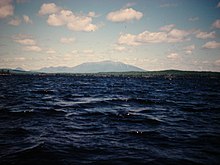
355:View up the Narrows into North Twin
1772:Lakes of Piscataquis County, Maine
596:Sprague's journal of Maine history
304:at 23,070 acres (93 km), and
14:
1777:Lakes of Penobscot County, Maine
707:from the original on 2021-12-28.
626:from the original on 2018-05-14.
81:
74:
51:
44:
27:
300:at 28,771 acres (116 km),
296:at 74,890 acres (303 km),
232:
224:
216:
208:
200:
192:
184:
975:West Branch Mattawamkeag River
828:East Branch Mattawamkeag River
593:Sprague, John Francis (1913).
334:The meaning of Pemadumcook in
33:Evening light, South Twin Lake
1:
1610:Bangor and Aroostook Railroad
989:West Branch Piscataquis River
842:East Branch Piscataquis River
573:, Alfred Geer Hempstead, 1975
319:. The lakes are part of the
103:
95:Show map of the United States
1638:Great Northern Paper Company
961:South Branch Penobscot River
905:North Branch Penobscot River
877:Middle Branch Pleasant River
614:"Pemadumcook Chain of Lakes"
389:Great Northern Paper Company
205:18,300 acres (7,400 ha)
982:West Branch Penobscot River
835:East Branch Penobscot River
1808:
1133:Pemadumcook Chain of Lakes
996:West Branch Pleasant River
849:East Branch Pleasant River
254:Pemadumcook Chain of Lakes
244:not a well-defined measure
89:Pemadumcook Chain of Lakes
59:Pemadumcook Chain of Lakes
22:Pemadumcook Chain of Lakes
638:"Maine Lakes Report 2012"
554:Appalachian Mountain Club
241:
112:Piscataquis County, Maine
38:
26:
954:South Branch Marsh River
898:North Branch Marsh River
758:Hamlin, Charles (1881).
619:. State of Maine. 1954.
493:) and small mouth bass (
1652:Hundred-Mile Wilderness
109:Penobscot County, Maine
1701:Peaks-Kenny State Park
1666:Maine Central Railroad
721:(1864). "Warping Up".
700:. Maine Memory. 2005.
581:, University of Maine.
562:
546:
531:
356:
310:Mooselookmeguntic Lake
229:65 miles (100 km)
558:
552:, the journal of the
542:
527:
491:Micropterus salmoides
489:), large mouth bass (
421:45.59920°N 68.82070°W
354:
276:or Joseph Chadwick's
237:492 feet (150 m)
197:2.5 miles (4 km)
189:14 miles (23 km)
1750:Waldo–Hancock Bridge
863:Little Seboeis River
719:Thoreau, Henry David
538:Life in the Open Air
495:Micropterus dolomieu
377:Maine State Route 11
221:103 feet (31 m)
1736:University of Maine
1659:Katahdin Iron Works
519:Henry David Thoreau
453:(landlocked type),
426:45.59920; -68.82070
417: /
213:35 feet (11 m)
137: /
1063:Grand Lake Seboeis
919:Passadumkeag River
870:Mattawamkeag River
739:Winthrop, Theodore
513:Charles Turner, Jr
357:
1782:North Maine Woods
1759:
1758:
1687:North Maine Woods
1617:Baxter State Park
1217:Upper Wilson Pond
1098:Mattawamkeag Lake
1084:Lower Wilson Pond
1021:Canada Falls Lake
926:Piscataquis River
891:Narramissic River
856:Kenduskeag Stream
670:"Large Crown Map"
668:Joseph Chadwick.
534:Theodore Winthrop
400:Baxter State Park
385:Baxter State Park
370:Appalachian Trail
329:Appalachian Trail
250:
249:
234:Surface elevation
141:45.700°N 68.950°W
65:Show map of Maine
1799:
1752:
1745:
1738:
1731:
1724:
1717:
1710:
1703:
1696:
1689:
1682:
1675:
1668:
1661:
1654:
1647:
1640:
1633:
1626:
1619:
1612:
1594:
1587:
1580:
1573:
1566:
1559:
1552:
1545:
1538:
1531:
1524:
1517:
1510:
1503:
1496:
1489:
1482:
1475:
1468:
1461:
1454:
1447:
1440:
1433:
1426:
1419:
1412:
1405:
1398:
1391:
1384:
1377:
1370:
1363:
1356:
1349:
1342:
1335:
1328:
1321:
1319:East Millinocket
1314:
1307:
1300:
1293:
1286:
1279:
1272:
1265:
1258:
1251:
1244:
1237:
1219:
1212:
1205:
1198:
1191:
1184:
1177:
1170:
1163:
1156:
1149:
1142:
1135:
1128:
1121:
1114:
1107:
1105:Millinocket Lake
1100:
1093:
1086:
1079:
1072:
1065:
1058:
1056:Debsconeag Lakes
1051:
1049:Cold Stream Pond
1044:
1037:
1035:Chamberlain Lake
1030:
1028:Caucomgomoc Lake
1023:
1016:
998:
991:
984:
977:
970:
968:Stillwater River
963:
956:
949:
942:
935:
928:
921:
914:
907:
900:
893:
886:
879:
872:
865:
858:
851:
844:
837:
830:
823:
798:
791:
784:
775:
766:
765:
755:
749:
748:
735:
729:
728:
715:
709:
708:
706:
699:
691:
685:
684:
682:
681:
676:on July 13, 2007
672:. Archived from
665:
659:
658:
656:
655:
649:
643:. Archived from
642:
634:
628:
627:
625:
618:
610:
601:
600:
590:
432:
431:
429:
428:
427:
422:
418:
415:
414:
413:
410:
393:Millinocket Lake
242:Shore length is
152:
151:
149:
148:
147:
142:
138:
135:
134:
133:
130:
120:
96:
85:
84:
78:
66:
55:
54:
48:
31:
19:
1807:
1806:
1802:
1801:
1800:
1798:
1797:
1796:
1787:Penobscot River
1762:
1761:
1760:
1755:
1748:
1741:
1734:
1727:
1722:Ripogenus Gorge
1720:
1713:
1706:
1699:
1692:
1685:
1678:
1673:Monson Railroad
1671:
1664:
1657:
1650:
1645:Great Works Dam
1643:
1636:
1629:
1622:
1615:
1608:
1597:
1590:
1583:
1576:
1569:
1562:
1555:
1548:
1541:
1534:
1527:
1520:
1513:
1506:
1499:
1492:
1485:
1478:
1471:
1464:
1457:
1450:
1443:
1436:
1429:
1422:
1415:
1408:
1401:
1394:
1387:
1380:
1373:
1366:
1359:
1352:
1345:
1338:
1331:
1324:
1317:
1310:
1303:
1296:
1289:
1282:
1275:
1268:
1261:
1254:
1247:
1240:
1233:
1222:
1215:
1208:
1201:
1196:South Twin Lake
1194:
1187:
1180:
1173:
1166:
1159:
1152:
1145:
1138:
1131:
1124:
1117:
1112:Nahmakanta Lake
1110:
1103:
1096:
1089:
1082:
1075:
1068:
1061:
1054:
1047:
1042:Chesuncook Lake
1040:
1033:
1026:
1019:
1012:
1001:
994:
987:
980:
973:
966:
959:
952:
945:
938:
931:
924:
917:
910:
903:
896:
889:
884:Molunkus Stream
882:
875:
868:
861:
854:
847:
840:
833:
826:
819:
808:
805:Penobscot River
802:
771:
769:
757:
756:
752:
737:
736:
732:
717:
716:
712:
704:
697:
693:
692:
688:
679:
677:
667:
666:
662:
653:
651:
647:
640:
636:
635:
631:
623:
616:
612:
611:
604:
592:
591:
587:
567:
540:(1856?) wrote:
523:The Maine Woods
507:Penobscot River
503:
451:Atlantic Salmon
439:
425:
423:
419:
416:
411:
408:
406:
404:
403:
362:
341:South Twin Lake
325:Penobscot River
317:South Twin Lake
302:Chesuncook Lake
286:
270:
172: countries
146:45.700; -68.950
145:
143:
139:
136:
131:
128:
126:
124:
123:
100:
99:
98:
97:
94:
93:
92:
91:
90:
86:
69:
68:
67:
64:
63:
62:
61:
60:
56:
34:
17:
12:
11:
5:
1805:
1803:
1795:
1794:
1792:Lakes of Maine
1789:
1784:
1779:
1774:
1764:
1763:
1757:
1756:
1754:
1753:
1746:
1739:
1732:
1729:Stillwater Dam
1725:
1718:
1711:
1704:
1697:
1690:
1683:
1680:Mount Katahdin
1676:
1669:
1662:
1655:
1648:
1641:
1634:
1627:
1620:
1613:
1605:
1603:
1599:
1598:
1596:
1595:
1588:
1581:
1574:
1567:
1560:
1553:
1546:
1539:
1532:
1525:
1518:
1511:
1504:
1497:
1490:
1483:
1476:
1469:
1462:
1455:
1448:
1441:
1434:
1427:
1420:
1413:
1406:
1399:
1392:
1385:
1378:
1371:
1364:
1357:
1350:
1343:
1336:
1329:
1322:
1315:
1312:Dover-Foxcroft
1308:
1301:
1294:
1287:
1280:
1273:
1266:
1259:
1252:
1245:
1238:
1230:
1228:
1224:
1223:
1221:
1220:
1213:
1206:
1199:
1192:
1189:Seboomook Lake
1185:
1178:
1171:
1164:
1157:
1150:
1143:
1136:
1129:
1122:
1115:
1108:
1101:
1094:
1091:Matagamon Lake
1087:
1080:
1073:
1066:
1059:
1052:
1045:
1038:
1031:
1024:
1017:
1009:
1007:
1003:
1002:
1000:
999:
992:
985:
978:
971:
964:
957:
950:
943:
936:
933:Pleasant River
929:
922:
915:
908:
901:
894:
887:
880:
873:
866:
859:
852:
845:
838:
831:
824:
816:
814:
810:
809:
803:
801:
800:
793:
786:
778:
768:
767:
750:
730:
724:The Main Woods
710:
686:
660:
629:
602:
584:
583:
582:
574:
566:
563:
502:
499:
487:Brown bullhead
459:Chain Pickerel
438:
435:
361:
358:
306:Flagstaff Lake
294:Moosehead Lake
290:Mount Katahdin
285:
282:
269:
266:
248:
247:
239:
238:
235:
231:
230:
227:
223:
222:
219:
215:
214:
211:
207:
206:
203:
199:
198:
195:
191:
190:
187:
183:
182:
179:
178:
173:
166:
165:
160:
154:
153:
121:
115:
114:
106:
102:
101:
88:
87:
80:
79:
73:
72:
71:
70:
58:
57:
50:
49:
43:
42:
41:
40:
39:
36:
35:
32:
24:
23:
15:
13:
10:
9:
6:
4:
3:
2:
1804:
1793:
1790:
1788:
1785:
1783:
1780:
1778:
1775:
1773:
1770:
1769:
1767:
1751:
1747:
1744:
1740:
1737:
1733:
1730:
1726:
1723:
1719:
1716:
1712:
1709:
1705:
1702:
1698:
1695:
1691:
1688:
1684:
1681:
1677:
1674:
1670:
1667:
1663:
1660:
1656:
1653:
1649:
1646:
1642:
1639:
1635:
1632:
1628:
1625:
1621:
1618:
1614:
1611:
1607:
1606:
1604:
1600:
1593:
1589:
1586:
1582:
1579:
1575:
1572:
1568:
1565:
1561:
1558:
1554:
1551:
1547:
1544:
1540:
1537:
1533:
1530:
1526:
1523:
1519:
1516:
1512:
1509:
1505:
1502:
1498:
1495:
1491:
1488:
1484:
1481:
1477:
1474:
1470:
1467:
1463:
1460:
1456:
1453:
1449:
1446:
1442:
1439:
1435:
1432:
1428:
1425:
1421:
1418:
1414:
1411:
1407:
1404:
1400:
1397:
1393:
1390:
1386:
1383:
1379:
1376:
1372:
1369:
1365:
1362:
1358:
1355:
1351:
1348:
1344:
1341:
1337:
1334:
1330:
1327:
1323:
1320:
1316:
1313:
1309:
1306:
1302:
1299:
1295:
1292:
1288:
1285:
1281:
1278:
1274:
1271:
1267:
1264:
1260:
1257:
1253:
1250:
1246:
1243:
1239:
1236:
1232:
1231:
1229:
1225:
1218:
1214:
1211:
1207:
1204:
1200:
1197:
1193:
1190:
1186:
1183:
1179:
1176:
1172:
1169:
1168:Schoodic Lake
1165:
1162:
1158:
1155:
1151:
1148:
1144:
1141:
1140:Pleasant Lake
1137:
1134:
1130:
1127:
1123:
1120:
1119:Nicatous Lake
1116:
1113:
1109:
1106:
1102:
1099:
1095:
1092:
1088:
1085:
1081:
1078:
1074:
1071:
1070:Jo-Mary Lakes
1067:
1064:
1060:
1057:
1053:
1050:
1046:
1043:
1039:
1036:
1032:
1029:
1025:
1022:
1018:
1015:
1014:Allagash Lake
1011:
1010:
1008:
1004:
997:
993:
990:
986:
983:
979:
976:
972:
969:
965:
962:
958:
955:
951:
948:
947:Seboeis River
944:
941:
937:
934:
930:
927:
923:
920:
916:
913:
909:
906:
902:
899:
895:
892:
888:
885:
881:
878:
874:
871:
867:
864:
860:
857:
853:
850:
846:
843:
839:
836:
832:
829:
825:
822:
818:
817:
815:
811:
806:
799:
794:
792:
787:
785:
780:
779:
776:
772:
763:
762:
754:
751:
746:
745:
740:
734:
731:
726:
725:
720:
714:
711:
703:
696:
690:
687:
675:
671:
664:
661:
650:on 2022-08-12
646:
639:
633:
630:
622:
615:
609:
607:
603:
598:
597:
589:
586:
580:
579:
575:
572:
569:
568:
564:
561:
557:
555:
551:
545:
541:
539:
535:
530:
526:
524:
520:
516:
514:
510:
508:
500:
498:
496:
492:
488:
484:
480:
476:
472:
468:
464:
460:
456:
452:
448:
444:
441:Fish include
436:
434:
430:
401:
396:
394:
390:
386:
382:
378:
373:
371:
367:
359:
353:
349:
345:
342:
337:
332:
330:
326:
322:
318:
313:
311:
307:
303:
299:
295:
291:
283:
281:
279:
275:
267:
265:
263:
262:United States
259:
255:
245:
240:
236:
228:
220:
212:
210:Average depth
204:
196:
188:
180:
177:
176:United States
174:
171:
167:
164:
161:
159:
155:
150:
122:
116:
113:
110:
107:
77:
47:
37:
30:
25:
20:
1515:Passadumkeag
1438:Mattawamkeag
1389:Island Falls
1182:Seboeis Lake
1161:Rainbow Lake
1132:
1077:Lobster Lake
912:Orland River
770:
760:
753:
743:
733:
723:
713:
689:
678:. Retrieved
674:the original
663:
652:. Retrieved
645:the original
632:
595:
588:
577:
570:
559:
549:
547:
543:
537:
532:
528:
522:
517:
511:
504:
485:, hornpout (
471:yellow perch
463:American Eel
440:
397:
374:
363:
346:
333:
314:
287:
278:Bennedumcook
277:
273:
271:
253:
251:
226:Shore length
202:Surface area
163:Natural lake
1631:Gero Island
1592:Wytopitlock
1557:Springfield
1536:Sangerville
1459:Millinocket
1361:Haynesville
1154:Ragged Lake
1147:Pushaw Lake
940:Sebec River
813:Tributaries
467:white perch
443:Brook Trout
424: /
381:Millinocket
321:West Branch
298:Sebago Lake
274:Pamadumcook
186:Max. length
144: /
119:Coordinates
1766:Categories
1743:Veazie Dam
1585:Winterport
1396:Kenduskeag
1298:Charleston
1284:Burlington
1270:Brownville
1210:Toddy Pond
1203:Telos Lake
1175:Sebec Lake
1126:Lake Onawa
821:Dead River
680:2008-12-26
654:2022-08-12
565:References
550:Appalachia
447:Lake Trout
412:68°49′15″W
409:45°35′57″N
272:Thoreau's
218:Max. depth
194:Max. width
1694:Orono Dam
1624:Fort Knox
1602:Landmarks
1508:Orrington
1340:Frankfort
1326:Eddington
1277:Bucksport
807:Watershed
483:sunfishes
455:Whitefish
366:Penobscot
360:Watershed
336:Penobscot
284:Geography
1529:Prospect
1487:Old Town
1480:Oakfield
1431:Macwahoc
1347:Guilford
1305:Danforth
741:(1863).
702:Archived
621:Archived
445:, Togue
105:Location
1543:Sherman
1452:Milford
1424:Lincoln
1403:Kingman
1375:Howland
1354:Hampden
1333:Enfield
1249:Bradley
501:History
479:minnows
323:of the
260:in the
132:68°57′W
129:45°42′N
1571:Verona
1564:Veazie
1550:Smyrna
1522:Patten
1494:Orland
1473:Monson
1445:Medway
1417:Levant
1382:Hudson
1368:Hermon
1291:Carmel
1263:Brooks
1256:Brewer
1242:Bangor
1501:Orono
1235:Abbot
1227:Towns
1006:Lakes
705:(PDF)
698:(PDF)
648:(PDF)
641:(PDF)
624:(PDF)
617:(PDF)
536:, in
475:chubs
258:Maine
170:Basin
1578:Winn
1466:Milo
437:Fish
268:Name
252:The
158:Type
1410:Lee
497:).
1768::
605:^
556::
525::
481:,
477:,
473:,
469:,
465:,
461:,
457:,
449:,
264:.
797:e
790:t
783:v
764:.
747:.
727:.
683:.
657:.
599:.
246:.
Text is available under the Creative Commons Attribution-ShareAlike License. Additional terms may apply.