331:
40:
729:
668:
252:
575:
656:
26:
569:
502:
463:
267:
122:
99:
78:
615:
141:
581:
535:
112:
370:
and heads north on Bull Run Road, leaving the state forest and heading through more wooded areas with some fields. PA 477 turns east onto West Winter Road and heads through agricultural areas in the Sugar Valley. The route turns north onto South Mill Street and passes through more rural areas before
330:
692:
893:
888:
810:
769:
394:
and runs a short distance to the north of I-80. The road turns northwest and heads away from the interstate as it passes through wooded residential areas and runs through
797:
756:
379:, becoming North Mill Street. PA 477 heads back into Greene Township and passes through a gap in forested Sugar Valley Mountain. The road reaches an interchange with
522:
390:
The route runs west-northwest through farmland with occasional residences before heading into another section of the Bald Eagle State Forest. PA 477 heads into
363:
859:
556:
450:
215:
235:
806:
765:
700:
53:
883:
398:. Following this, the route winds west through farmland and woodland with some homes. The road passes through the residential community of
225:
220:
230:
403:
207:
585:
407:
125:
380:
589:
538:
484:
391:
367:
347:
311:
299:
188:
115:
85:
630:
597:
445:
351:
295:
184:
542:
509:
474:
622:
593:
546:
513:
470:
384:
359:
319:
129:
505:
489:
466:
376:
372:
339:
307:
270:
255:
106:
102:
81:
618:
411:
343:
315:
144:
399:
672:
626:
395:
850:
660:
355:
39:
868:
877:
291:
164:
303:
174:
383:
and passes a few businesses, turning west onto Long Run Road and heading through
734:
354:, heading north on two-lane undivided Apple Ridge Road. The road heads across
410:
freeway. A short distance later, PA 477 ends at an intersection with
362:, turning to the west before heading northwest. The route heads into
858:
329:
25:
640:
1.000 mi = 1.609 km; 1.000 km = 0.621 mi
846:
841:
198:
180:
170:
160:
155:
135:
91:
72:
67:
59:
46:
21:
792:
790:
894:Transportation in Clinton County, Pennsylvania
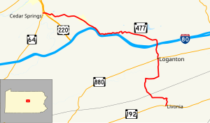
334:PA 477 northbound past I-80 in Greene Township
889:Transportation in Centre County, Pennsylvania
8:
860:Template:Attached KML/Pennsylvania Route 477
421:
375:. Here, the road passes homes and crosses
244:
863:
701:Pennsylvania Department of Transportation
799:Clinton County, Pennsylvania Highway Map
758:Centre County, Pennsylvania Highway Map
684:
338:PA 477 begins at an intersection with
18:
612:
606:
566:
560:
532:
526:
499:
493:
460:
454:
406:and reaching an interchange with the
290:) is a 17.7-mile-long (28.5 km)
7:
730:"overview of Pennsylvania Route 477"
724:
722:
720:
718:
63:17.681 mi (28.455 km)
14:
16:State highway in Pennsylvania, US
697:Pennsylvania Spatial Data Access
666:
654:
613:
579:
573:
567:
533:
500:
461:
265:
250:
139:
120:
110:
97:
76:
38:
24:
314:. The northern terminus is at
306:. The southern terminus is at
208:Pennsylvania State Route System
884:State highways in Pennsylvania
1:
869:Pennsylvania Highways: PA 477
469:(Brush Valley Road) –
910:
693:"Pennsylvania state roads"
639:
634:
609:
601:
563:
555:
550:
529:
521:
517:
496:
488:
483:
478:
457:
449:
444:
439:
436:
433:
430:
427:
424:
243:
203:
194:
151:
51:
37:
371:entering the borough of
673:Pennsylvania portal
621:(Fernberg Road) –
360:Bald Eagle State Forest
809:. 2011. Archived from
768:. 2011. Archived from
335:
284:Pennsylvania Route 477
31:Pennsylvania Route 477
661:U.S. Roads portal
508:(Main Street) –
333:
864:KML is from Wikidata
342:in the community of
816:on November 6, 2011
418:Major intersections
93:Major intersections
775:on August 29, 2011
336:
645:
644:
635:Northern terminus
602:Exit 107 (US 220)
479:Southern terminus
326:Route description
281:
280:
277:
276:
47:Route information
901:
854:
826:
825:
823:
821:
815:
804:
794:
785:
784:
782:
780:
774:
763:
753:
747:
746:
744:
742:
726:
713:
712:
710:
708:
689:
671:
670:
669:
659:
658:
657:
617:
616:
584:
583:
582:
577:
576:
571:
570:
537:
536:
504:
503:
465:
464:
422:
402:before crossing
356:Nittany Mountain
273:
269:
268:
258:
254:
253:
245:
143:
142:
124:
123:
114:
113:
101:
100:
94:
80:
79:
42:
28:
19:
909:
908:
904:
903:
902:
900:
899:
898:
874:
873:
865:
862:
857:
856:
855:
839:
835:
830:
829:
819:
817:
813:
802:
796:
795:
788:
778:
776:
772:
761:
755:
754:
750:
740:
738:
728:
727:
716:
706:
704:
691:
690:
686:
681:
667:
665:
655:
653:
650:
641:
614:
580:
578:
574:
572:
568:
551:Exit 185 (I-80)
534:
523:Greene Township
501:
462:
420:
364:Greene Township
328:
266:
264:
251:
249:
140:
121:
119:
111:
109:
98:
92:
77:
68:Major junctions
33:
32:
29:
17:
12:
11:
5:
907:
905:
897:
896:
891:
886:
876:
875:
872:
871:
838:
837:
836:
834:
833:External links
831:
828:
827:
786:
748:
714:
683:
682:
680:
677:
676:
675:
663:
649:
646:
643:
642:
637:
636:
633:
611:
608:
604:
603:
600:
565:
562:
559:
557:Lamar Township
553:
552:
549:
531:
528:
525:
519:
518:
516:
498:
495:
492:
487:
481:
480:
477:
459:
456:
453:
451:Miles Township
448:
442:
441:
438:
435:
432:
429:
426:
419:
416:
392:Lamar Township
368:Clinton County
348:Miles Township
327:
324:
312:Miles Township
279:
278:
275:
274:
261:
259:
241:
240:
239:
238:
233:
228:
223:
218:
212:
211:
201:
200:
199:Highway system
196:
195:
192:
191:
182:
178:
177:
172:
168:
167:
162:
158:
157:
153:
152:
149:
148:
147:near Mill Hall
137:
136:North end
133:
132:
95:
89:
88:
86:Miles Township
74:
73:South end
70:
69:
65:
64:
61:
57:
56:
52:Maintained by
49:
48:
44:
43:
35:
34:
30:
23:
22:
15:
13:
10:
9:
6:
4:
3:
2:
906:
895:
892:
890:
887:
885:
882:
881:
879:
870:
867:
866:
861:
852:
848:
844:
843:
832:
812:
808:
801:
800:
793:
791:
787:
771:
767:
760:
759:
752:
749:
737:
736:
731:
725:
723:
721:
719:
715:
702:
698:
694:
688:
685:
678:
674:
664:
662:
652:
651:
647:
638:
632:
631:State College
628:
624:
620:
605:
599:
598:State College
595:
591:
587:
558:
554:
548:
544:
540:
524:
520:
515:
511:
507:
491:
486:
482:
476:
472:
468:
452:
447:
443:
423:
417:
415:
413:
409:
405:
404:Fishing Creek
401:
397:
393:
388:
386:
382:
378:
374:
369:
365:
361:
357:
353:
352:Centre County
349:
345:
341:
332:
325:
323:
321:
317:
313:
309:
305:
301:
297:
293:
292:state highway
289:
285:
272:
262:
260:
257:
247:
246:
242:
237:
234:
232:
229:
227:
224:
222:
219:
217:
214:
213:
210:
209:
205:
204:
202:
197:
193:
190:
186:
183:
179:
176:
173:
169:
166:
165:United States
163:
159:
154:
150:
146:
138:
134:
131:
127:
118:near Loganton
117:
108:
104:
96:
90:
87:
83:
75:
71:
66:
62:
58:
55:
50:
45:
41:
36:
27:
20:
840:
818:. Retrieved
811:the original
798:
777:. Retrieved
770:the original
757:
751:
739:. Retrieved
733:
705:. Retrieved
696:
687:
543:Williamsport
510:Jersey Shore
437:Destinations
389:
337:
304:Pennsylvania
302:counties in
287:
283:
282:
206:
175:Pennsylvania
735:Google Maps
586:US 220
506:PA 880
475:Centre Hall
467:PA 192
294:located in
271:PA 478
256:PA 476
236:Legislative
126:US 220
103:PA 880
82:PA 192
878:Categories
679:References
623:Lock Haven
619:PA 64
594:Lock Haven
547:Bellefonte
514:Rebersburg
216:Interstate
145:PA 64
707:March 14,
471:Lewisburg
385:Rosecrans
320:Mill Hall
130:Mill Hall
842:KML file
648:See also
592: –
541: –
490:Loganton
428:Location
373:Loganton
181:Counties
156:Location
107:Loganton
820:July 9,
807:PennDOT
805:(Map).
779:May 27,
766:PennDOT
764:(Map).
741:July 9,
732:(Map).
485:Clinton
358:in the
344:Livonia
300:Clinton
189:Clinton
161:Country
54:PennDOT
703:. 2013
446:Centre
425:County
408:US 220
400:Salona
377:PA 880
340:PA 192
308:PA 192
296:Centre
288:PA 477
231:Scenic
185:Centre
60:Length
814:(PDF)
803:(PDF)
773:(PDF)
762:(PDF)
627:Lamar
440:Notes
412:PA 64
318:near
316:PA 64
226:State
171:State
128:near
851:help
847:edit
822:2011
781:2011
743:2011
709:2013
610:28.3
607:17.6
590:I-80
564:28.2
561:17.5
539:I-80
530:11.6
396:Rote
381:I-80
298:and
116:I-80
588:to
527:7.2
497:9.7
494:6.0
458:0.0
455:0.0
366:in
346:in
310:in
105:in
84:in
880::
849:•
789:^
717:^
699:.
695:.
629:,
625:,
596:,
545:,
512:,
473:,
434:km
431:mi
414:.
387:.
350:,
322:.
263:→
248:←
221:US
187:,
853:)
845:(
824:.
783:.
745:.
711:.
286:(
Text is available under the Creative Commons Attribution-ShareAlike License. Additional terms may apply.