312:
273:
533:
473:
213:
461:
26:
288:, where the road connects to Black Valley Road and Gap Road NE south of the state line. From this point, the route heads north on two-lane undivided South Black Valley Road, passing through an agricultural valley with some woods and homes. The road curves more to the northeast, turning east onto Chaneysville Road and passing through a gap in
198:
420:
88:
331:. After the latter, the route turns north onto Egolf Road, heading through more agricultural areas with some woods and homes. The surroundings become more forested before the road passes through more farmland with a few woods and residences, bending to the north-northeast. PA 326 crosses into
292:. PA 326 reaches the community of Hewitt, at which point the road winds north through farmland and woodland in another narrow valley. The route continues through the valley for several miles, curving east before turning north onto Chaneysville Cove Road near the community of
311:
500:
647:
563:
382:
285:
300:. PA 326 turns north onto Black Valley Road and runs through forested areas with some farms. The route bears west onto Main Road, turning west into forests and crossing
320:
305:
618:
161:
181:
335:, where it makes a turn northwest to continue along Egolf Road. The road passes through wooded areas with a few homes, running to the southwest of the
572:
508:
48:
327:. Here, the route passes several homes. PA 326 heads back into Colerain Township and enters open agricultural areas, passing through Beegletown and
642:
323:
and leaves the state forest, curving to the northwest. The road heads into an agricultural valley and turns north, crossing into the borough of
171:
407:
332:
166:
176:
296:. The road curves northwest and passes through another gap in warrior ridge, at which point it passes through a portion of the
153:
423:
340:
336:
257:
91:
356:
241:
134:
328:
293:
324:
216:
201:
435:
431:
344:
297:
261:
95:
272:
394:
253:
76:
477:
609:
465:
427:
301:
627:
636:
289:
237:
114:
245:
124:
538:
399:
281:
249:
72:
617:
310:
271:
25:
339:. PA 326 reaches its northern terminus at an intersection with
445:
1.000 mi = 1.609 km; 1.000 km = 0.621 mi
605:
600:
308:
and passes through more of the
Buchanan State Forest.
144:
130:
120:
110:
105:
82:
67:
62:
54:
41:
21:
304:. After a bend to the north, the road heads into
16:State highway in Bedford County, Pennsylvania, US
558:
556:
648:Transportation in Bedford County, Pennsylvania
8:
619:Template:Attached KML/Pennsylvania Route 326
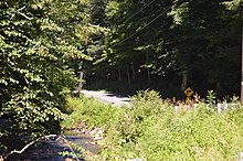
276:PA 326 at Black Valley Gap in Warrior Ridge
361:
190:
622:
509:Pennsylvania Department of Transportation
565:Bedford County, Pennsylvania Highway Map
495:
493:
489:
315:PA 326 northbound in Colerain Township
18:
417:
411:
392:
386:
7:
534:"overview of Pennsylvania Route 326"
528:
526:
58:23.883 mi (38.436 km)
248:. The southern terminus is at the
71:Black Valley Road / Gap Road NE at
393:Black Valley Road / Gap Road NE –
14:
236:) is a 24-mile-long (39 km)
505:Pennsylvania Spatial Data Access
471:
459:
418:
211:
196:
86:
24:
154:Pennsylvania State Route System
643:State highways in Pennsylvania
256:. The northern terminus is at
1:
628:Pennsylvania Highways: PA 326
337:Raystown Branch Juniata River
664:
501:"Pennsylvania state roads"
444:
439:
414:
406:
402:border; southern terminus
398:
389:
381:
376:
373:
370:
367:
364:
189:
149:
140:
101:
46:
37:
478:Pennsylvania portal
355:The entire route is in
343:east of the borough of
316:
277:
230:Pennsylvania Route 326
31:Pennsylvania Route 326
466:U.S. Roads portal
408:Snake Spring Township
333:Snake Spring Township
314:
298:Buchanan State Forest
280:PA 326 begins at the
275:
623:KML is from Wikidata
383:Southampton Township
286:Southampton Township
254:Flintstone, Maryland
351:Major intersections
317:
278:
450:
449:
440:Northern terminus
321:Colerain Township
268:Route description
227:
226:
223:
222:
42:Route information
655:
613:
585:
584:
582:
580:
570:
560:
551:
550:
548:
546:
530:
521:
520:
518:
516:
497:
476:
475:
474:
464:
463:
462:
422:
421:
362:
260:(US 30) east of
252:state line near
219:
215:
214:
204:
200:
199:
191:
90:
89:
75:state line near
28:
19:
663:
662:
658:
657:
656:
654:
653:
652:
633:
632:
624:
621:
616:
615:
614:
598:
594:
589:
588:
578:
576:
568:
562:
561:
554:
544:
542:
532:
531:
524:
514:
512:
499:
498:
491:
486:
472:
470:
460:
458:
455:
446:
428:Lincoln Highway
419:
353:
306:Monroe Township
302:Tussey Mountain
270:
212:
210:
197:
195:
87:
63:Major junctions
33:
32:
29:
17:
12:
11:
5:
661:
659:
651:
650:
645:
635:
634:
631:
630:
597:
596:
595:
593:
592:External links
590:
587:
586:
552:
522:
488:
487:
485:
482:
481:
480:
468:
454:
451:
448:
447:
442:
441:
438:
416:
413:
410:
404:
403:
397:
391:
388:
385:
379:
378:
375:
372:
369:
366:
357:Bedford County
352:
349:
319:PA 326 enters
269:
266:
242:Bedford County
225:
224:
221:
220:
207:
205:
187:
186:
185:
184:
179:
174:
169:
164:
158:
157:
147:
146:
145:Highway system
142:
141:
138:
137:
132:
128:
127:
122:
118:
117:
112:
108:
107:
103:
102:
99:
98:
84:
83:North end
80:
79:
77:Flintstone, MD
69:
68:South end
65:
64:
60:
59:
56:
52:
51:
47:Maintained by
44:
43:
39:
38:
35:
34:
30:
23:
22:
15:
13:
10:
9:
6:
4:
3:
2:
660:
649:
646:
644:
641:
640:
638:
629:
626:
625:
620:
611:
607:
603:
602:
591:
574:
567:
566:
559:
557:
553:
541:
540:
535:
529:
527:
523:
510:
506:
502:
496:
494:
490:
483:
479:
469:
467:
457:
456:
452:
443:
437:
433:
429:
425:
409:
405:
401:
396:
384:
380:
363:
360:
358:
350:
348:
346:
342:
338:
334:
330:
326:
322:
313:
309:
307:
303:
299:
295:
291:
290:Warrior Ridge
287:
283:
274:
267:
265:
263:
259:
258:U.S. Route 30
255:
251:
247:
243:
239:
238:state highway
235:
231:
218:
208:
206:
203:
193:
192:
188:
183:
180:
178:
175:
173:
170:
168:
165:
163:
160:
159:
156:
155:
151:
150:
148:
143:
139:
136:
133:
129:
126:
123:
119:
116:
115:United States
113:
109:
104:
100:
97:
93:
85:
81:
78:
74:
70:
66:
61:
57:
53:
50:
45:
40:
36:
27:
20:
599:
577:. Retrieved
564:
543:. Retrieved
537:
513:. Retrieved
504:
374:Destinations
354:
329:Charlesville
318:
294:Chaneysville
279:
246:Pennsylvania
233:
229:
228:
152:
125:Pennsylvania
539:Google Maps
240:located in
217:PA 327
202:PA 325
182:Legislative
637:Categories
484:References
424:US 30
395:Flintstone
284:border in
162:Interstate
92:US 30
515:March 14,
430:) –
325:Rainsburg
601:KML file
453:See also
400:Maryland
365:Location
282:Maryland
250:Maryland
131:Counties
106:Location
73:Maryland
579:May 20,
573:PennDOT
571:(Map).
545:May 20,
536:(Map).
436:Everett
432:Bedford
345:Bedford
262:Bedford
135:Bedford
111:Country
96:Bedford
49:PennDOT
575:. 2011
511:. 2013
415:38.436
412:23.883
234:PA 326
177:Scenic
55:Length
569:(PDF)
390:0.000
387:0.000
377:Notes
341:US 30
172:State
121:State
94:near
610:help
606:edit
581:2011
547:2011
517:2013
639::
608:•
555:^
525:^
507:.
503:.
492:^
434:,
371:km
368:mi
359:.
347:.
264:.
244:,
209:→
194:←
167:US
612:)
604:(
583:.
549:.
519:.
426:(
232:(
Text is available under the Creative Commons Attribution-ShareAlike License. Additional terms may apply.