56:
55:
40:
66:
273:
225:
170:
1251:
414:
1308:
400:
667:
660:
340:. It is the westernmost of the skerries. At one kilometre (five furlongs) long and rising to an elevation of 20 metres (65 feet) above sea level, it is sizable enough to be considered an
653:
1393:
1155:
1072:
999:
885:
432:
1349:
1212:
556:
461:
344:. However, the notoriously bad weather of the firth has historically rendered Muckle Skerry uninhabitable and as such it is more often thought of as a
1292:
1373:
1368:
336:
1388:
385:
163:
523:
1342:
39:
1383:
549:
427:
65:
1378:
1285:
332:
104:
31:
111:
1335:
1022:
785:
745:
840:
1047:
542:
680:
377:
1278:
1193:
1188:
1145:
1130:
924:
909:
800:
750:
1178:
1173:
1125:
1027:
989:
944:
735:
705:
381:
159:
1110:
1140:
979:
949:
919:
875:
780:
765:
700:
361:
904:
725:
720:
481:
1095:
1052:
880:
835:
820:
740:
715:
710:
289:
272:
224:
169:
1183:
1062:
994:
357:
1198:
1090:
934:
419:
645:
1067:
974:
825:
617:
602:
308:
85:
1250:
865:
805:
17:
969:
810:
629:
405:
1319:
1307:
1262:
964:
959:
939:
760:
730:
328:
97:
413:
1362:
755:
494:
1135:
850:
845:
830:
1165:
1150:
914:
870:
795:
597:
529:
1315:
984:
855:
815:
676:
577:
395:
1227:
1214:
453:
126:
113:
1120:
1105:
1100:
790:
775:
612:
592:
534:
1082:
1042:
1037:
1032:
1017:
896:
688:
587:
312:
93:
929:
860:
365:
1258:
1009:
954:
582:
566:
345:
341:
89:
1115:
770:
634:
607:
38:
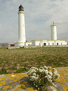
388:(this was the first light that Stevenson officially worked on).
649:
538:
376:
Pentland
Skerries Lighthouse was constructed in 1794 by the
364:
because it supports significant breeding populations of
1323:
1266:
1164:
1081:
1008:
894:
687:
288:
280:
265:
257:
249:
244:
232:
217:
209:
201:
193:
185:
177:
155:
147:
142:
103:
79:
356:The skerry is part of the Pentland Firth Islands
484:Northern Lighthouse Board. Retrieved 26 May 2016
1343:
1286:
661:
550:
433:List of Northern Lighthouse Board lighthouses
8:
50:
1394:United Kingdom building and structure stubs
462:University of North Carolina at Chapel Hill
1350:
1336:
1293:
1279:
668:
654:
646:
557:
543:
535:
271:
223:
205:cylindrical tower with balcony and lantern
168:
70:Pentland Skerries High and Low Lighthouses
64:
49:
444:
213:white tower, black lantern, ochre trim
7:
1304:
1302:
1247:
1245:
378:Commissioners of the Northern Lights
43:Aerial photograph of Muckle Skerry
25:
454:"Lighthouses of Scotland: Orkney"
1306:
1249:
412:
398:
311:that lie off the north coast of
54:
428:List of lighthouses in Scotland
1374:Important Bird Areas of Orkney
501:. BirdLife International. 2024
1:
1369:Uninhabited islands of Orkney
27:Island off the Scottish coast
1322:. You can help Knowledge by
1265:. You can help Knowledge by
372:Pentland Skerries Lighthouse
317:Pentland Skerries Lighthouse
51:Pentland Skerries High Light
32:Muckle Holm (disambiguation)
18:Pentland Skerries Lighthouse
1410:
1301:
1244:
1199:Thousla Rock (minor light)
327:Muckle Skerry lies in the
29:
1389:European lighthouse stubs
681:Northern Lighthouse Board
573:
530:Northern Lighthouse Board
526:Northern Lighthouse Board
298:
240:
236:Northern Lighthouse Board
75:
63:
495:"Pentland Firth Islands"
458:The Lighthouse Directory
360:(IBA), so designated by
284:23 nmi (43 km)
30:Not to be confused with
261:52 m (171 ft)
197:36 m (118 ft)
1384:Orkney geography stubs
1318:-related article is a
1261:location article is a
1184:Langness (minor light)
362:BirdLife International
307:is the largest of the
127:58.690221°N 2.924735°W
44:
380:. The engineers were
269:710,000 candela
42:
1379:Skerries of Scotland
1228:58.68824°N 2.92631°W
315:. It is home to the
132:58.690221; -2.924735
1224: /
786:Holy Island (Outer)
358:Important Bird Area
352:Important Bird Area
123: /
60:
1233:58.68824; -2.92631
1141:Point of Fethaland
692:(except principal
499:BirdLife Data Zone
420:Engineering portal
294:Fl (3) W 30 s
45:
1331:
1330:
1274:
1273:
1207:
1206:
1058:Pentland Skerries
643:
642:
618:Pentland Skerries
603:Horse of Copinsay
524:Pentland Skerries
482:Pentland Skerries
309:Pentland Skerries
302:
301:
221:solar power
86:Pentland Skerries
16:(Redirected from
1401:
1352:
1345:
1338:
1310:
1303:
1295:
1288:
1281:
1253:
1246:
1239:
1238:
1236:
1235:
1234:
1229:
1225:
1222:
1221:
1220:
1217:
1038:Hoy Sound (High)
1023:Brough of Birsay
806:Mull of Galloway
746:Covesea Skerries
670:
663:
656:
647:
559:
552:
545:
536:
511:
510:
508:
506:
491:
485:
479:
473:
472:
470:
468:
449:
422:
417:
416:
408:
403:
402:
401:
386:Robert Stevenson
384:and his stepson
339:
276:
275:
228:
227:
173:
172:
164:Robert Stevenson
138:
137:
135:
134:
133:
128:
124:
121:
120:
119:
116:
68:
61:
59:
58:
21:
1409:
1408:
1404:
1403:
1402:
1400:
1399:
1398:
1359:
1358:
1357:
1356:
1300:
1299:
1242:
1232:
1230:
1226:
1223:
1218:
1215:
1213:
1211:
1210:
1208:
1203:
1160:
1106:Fair Isle South
1101:Fair Isle North
1077:
1048:North Ronaldsay
1043:Hoy Sound (Low)
1004:
970:Rona Lighthouse
925:Flannan Islands
890:
811:Mull of Kintyre
693:
691:
683:
674:
644:
639:
630:South Ronaldsay
569:
563:
520:
515:
514:
504:
502:
493:
492:
488:
480:
476:
466:
464:
452:Rowlett, Russ.
451:
450:
446:
441:
418:
411:
406:Scotland portal
404:
399:
397:
394:
374:
354:
335:
325:
270:
222:
167:
131:
129:
125:
122:
117:
114:
112:
110:
109:
96:
92:
88:
84:
71:
52:
48:
35:
28:
23:
22:
15:
12:
11:
5:
1407:
1405:
1397:
1396:
1391:
1386:
1381:
1376:
1371:
1361:
1360:
1355:
1354:
1347:
1340:
1332:
1329:
1328:
1311:
1298:
1297:
1290:
1283:
1275:
1272:
1271:
1254:
1205:
1204:
1202:
1201:
1196:
1191:
1186:
1181:
1176:
1170:
1168:
1162:
1161:
1159:
1158:
1153:
1148:
1143:
1138:
1133:
1128:
1123:
1118:
1113:
1108:
1103:
1098:
1093:
1087:
1085:
1079:
1078:
1076:
1075:
1070:
1065:
1060:
1055:
1050:
1045:
1040:
1035:
1030:
1025:
1020:
1014:
1012:
1006:
1005:
1003:
1002:
997:
992:
987:
982:
977:
972:
967:
965:Rubha nan Gall
962:
960:Rinns of Islay
957:
952:
947:
942:
937:
932:
927:
922:
917:
912:
907:
901:
899:
892:
891:
889:
888:
883:
878:
873:
868:
863:
858:
853:
848:
843:
838:
833:
828:
823:
818:
813:
808:
803:
798:
793:
788:
783:
778:
773:
768:
763:
761:Duncansby Head
758:
753:
748:
743:
738:
733:
728:
723:
718:
713:
708:
703:
697:
695:
694:island groups)
685:
684:
675:
673:
672:
665:
658:
650:
641:
640:
638:
637:
632:
627:
626:
625:
615:
610:
605:
600:
595:
590:
585:
580:
574:
571:
570:
567:Orkney Islands
564:
562:
561:
554:
547:
539:
533:
532:
527:
519:
518:External links
516:
513:
512:
486:
474:
443:
442:
440:
437:
436:
435:
430:
424:
423:
409:
393:
390:
373:
370:
353:
350:
333:grid reference
329:Pentland Firth
324:
321:
300:
299:
296:
295:
292:
290:Characteristic
286:
285:
282:
278:
277:
267:
263:
262:
259:
255:
254:
251:
247:
246:
242:
241:
238:
237:
234:
230:
229:
219:
215:
214:
211:
207:
206:
203:
199:
198:
195:
191:
190:
187:
183:
182:
179:
175:
174:
157:
153:
152:
149:
145:
144:
140:
139:
107:
101:
100:
98:United Kingdom
81:
77:
76:
73:
72:
69:
46:
26:
24:
14:
13:
10:
9:
6:
4:
3:
2:
1406:
1395:
1392:
1390:
1387:
1385:
1382:
1380:
1377:
1375:
1372:
1370:
1367:
1366:
1364:
1353:
1348:
1346:
1341:
1339:
1334:
1333:
1327:
1325:
1321:
1317:
1314:This British
1312:
1309:
1305:
1296:
1291:
1289:
1284:
1282:
1277:
1276:
1270:
1268:
1264:
1260:
1255:
1252:
1248:
1243:
1240:
1237:
1200:
1197:
1195:
1194:Point of Ayre
1192:
1190:
1189:Maughold Head
1187:
1185:
1182:
1180:
1177:
1175:
1172:
1171:
1169:
1167:
1163:
1157:
1154:
1152:
1149:
1147:
1146:Sumburgh Head
1144:
1142:
1139:
1137:
1134:
1132:
1131:Muckle Flugga
1129:
1127:
1124:
1122:
1119:
1117:
1114:
1112:
1109:
1107:
1104:
1102:
1099:
1097:
1094:
1092:
1089:
1088:
1086:
1084:
1080:
1074:
1071:
1069:
1066:
1064:
1061:
1059:
1056:
1054:
1051:
1049:
1046:
1044:
1041:
1039:
1036:
1034:
1031:
1029:
1026:
1024:
1021:
1019:
1016:
1015:
1013:
1011:
1007:
1001:
998:
996:
993:
991:
988:
986:
983:
981:
978:
976:
973:
971:
968:
966:
963:
961:
958:
956:
953:
951:
948:
946:
943:
941:
938:
936:
933:
931:
928:
926:
923:
921:
918:
916:
913:
911:
910:Butt of Lewis
908:
906:
903:
902:
900:
898:
893:
887:
884:
882:
879:
877:
874:
872:
869:
867:
864:
862:
861:Strathy Point
859:
857:
854:
852:
849:
847:
844:
842:
839:
837:
834:
832:
829:
827:
824:
822:
819:
817:
814:
812:
809:
807:
804:
802:
801:Kinnaird Head
799:
797:
794:
792:
789:
787:
784:
782:
779:
777:
774:
772:
769:
767:
764:
762:
759:
757:
754:
752:
749:
747:
744:
742:
739:
737:
734:
732:
729:
727:
724:
722:
719:
717:
714:
712:
709:
707:
704:
702:
699:
698:
696:
690:
686:
682:
678:
671:
666:
664:
659:
657:
652:
651:
648:
636:
633:
631:
628:
624:
623:Muckle Skerry
621:
620:
619:
616:
614:
611:
609:
606:
604:
601:
599:
596:
594:
591:
589:
586:
584:
581:
579:
576:
575:
572:
568:
560:
555:
553:
548:
546:
541:
540:
537:
531:
528:
525:
522:
521:
517:
500:
496:
490:
487:
483:
478:
475:
463:
459:
455:
448:
445:
438:
434:
431:
429:
426:
425:
421:
415:
410:
407:
396:
391:
389:
387:
383:
379:
371:
369:
367:
363:
359:
351:
349:
347:
343:
338:
334:
330:
322:
320:
318:
314:
310:
306:
305:Muckle Skerry
297:
293:
291:
287:
283:
279:
274:
268:
264:
260:
256:
253:1820s rebuilt
252:
248:
243:
239:
235:
231:
226:
220:
216:
212:
208:
204:
200:
196:
192:
188:
184:
180:
176:
171:
165:
161:
158:
154:
150:
146:
141:
136:
108:
106:
102:
99:
95:
91:
87:
83:Muckle Skerry
82:
78:
74:
67:
62:
57:
41:
37:
33:
19:
1324:expanding it
1313:
1267:expanding it
1256:
1241:
1209:
1179:Douglas Head
1174:Chicken Rock
1156:Minor lights
1136:Out Skerries
1073:Minor lights
1057:
1028:Cantick Head
1000:Minor lights
990:Tiumpan Head
886:Minor lights
851:Scurdie Ness
841:St Abbs Head
831:Rattray Head
751:Crammag Head
736:Corran Point
706:Ardnamurchan
622:
503:. Retrieved
498:
489:
477:
465:. Retrieved
457:
447:
382:Thomas Smith
375:
355:
326:
316:
304:
303:
258:Focal height
218:Power source
178:Construction
160:Thomas Smith
36:
1231: /
1166:Isle of Man
1151:Ve Skerries
1126:Little Holm
1063:Start Point
950:Neist Point
920:Eilean Glas
915:Dubh Artach
876:Tarbat Ness
871:Sule Skerry
796:Isle of May
781:Girdle Ness
766:Dunnet Head
721:Buchan Ness
701:Ailsa Craig
677:Lighthouses
598:Glimps Holm
565:South East
181:stone tower
148:Constructed
130: /
105:Coordinates
1363:Categories
1316:lighthouse
1216:58°41′18″N
1111:Firths Voe
985:Skerryvore
905:Barra Head
856:Stoer Head
816:North Rona
726:Cape Wrath
578:Black Holm
439:References
115:58°41′25″N
47:Lighthouse
1219:2°55′35″W
1121:Hoo Stack
1053:Noup Head
980:Scarinish
881:Turnberry
821:Noss Head
791:Inchkeith
776:Fife Ness
741:Corsewall
716:Bell Rock
711:Bass Rock
613:Lamb Holm
593:Corn Holm
505:30 August
323:Geography
266:Intensity
250:First lit
186:Automated
118:2°55′29″W
1096:Eshaness
1083:Shetland
1068:Tor Ness
1033:Copinsay
1018:Auskerry
995:Ushenish
897:Hebrides
731:Chanonry
689:Scotland
588:Copinsay
392:See also
366:seabirds
337:ND464782
313:Scotland
233:Operator
210:Markings
156:Built by
94:Scotland
80:Location
1091:Bressay
940:Lismore
935:Hyskeir
930:Haskeir
836:Rubh Re
679:of the
1259:Orkney
1010:Orkney
975:Ruvaal
955:Ornsay
945:Monach
866:Stroma
826:Pladda
756:Davaar
583:Burray
467:26 May
346:skerry
342:island
194:Height
166:
90:Orkney
1257:This
1116:Foula
846:Sanda
771:Fidra
635:Swona
608:Hunda
281:Range
245:Light
202:Shape
143:Tower
53:
1320:stub
1263:stub
895:The
507:2024
469:2016
189:1994
151:1794
331:at
1365::
497:.
460:.
456:.
368:.
348:.
319:.
162:,
1351:e
1344:t
1337:v
1326:.
1294:e
1287:t
1280:v
1269:.
669:e
662:t
655:v
558:e
551:t
544:v
509:.
471:.
34:.
20:)
Text is available under the Creative Commons Attribution-ShareAlike License. Additional terms may apply.